Follow the Footsteps of the BBC Winter Walks Presenters
Immerse yourself in the tranquil beauty of Northern England as I follow in the footsteps of the nine presenters of the BBC Winter Walks series 1 and series 2. Where did they roam and explore? Which maps guided their journeys along the paths, tracks, and roads of the British countryside? In this comprehensive guide, I’ll provide all these answers and more.
The BBC Winter Walks series offers a unique glimpse into some of the most scenic winter landscapes across the North of England. From Selina Scott’s journey through the idyllic hamlets of Wharfedale to Richard Coles’ contemplative ramble in the historic North York Moors, each episode of the series paints a vivid portrait of England’s beautiful countryside.
In this article, I’ll take you along the very routes the presenters took, aided by maps and the same walking paths they would have followed. From the Yorkshire Dales to the North York Moors and the heart-stopping views from Morecambe Bay, you will experience these trails virtually, with all their raw beauty and serenity.
So, as I embark on this journey, you will not only follow in the presenters’ footsteps but also see through their eyes the picturesque charm and allure of these winter walks. Whether you’re planning your own countryside trek, researching British landscapes, or simply wanting to indulge in the captivating narratives and stunning visuals, this guide to the BBC Winter Walks series will prove invaluable.
If you’re inspired by these enchanting winter walks and keen to embark on your own exploration, be sure to check out my other blog posts. For an extensive guide on more mesmerising Yorkshire Dales trails, head over to Best Walks in the Yorkshire Dales: Discover 23 Breathtaking Trails. Meanwhile, for those fascinated by the captivating North York Moors, you’ll find lots more routes in Best Walks in the North York Moors: 17 Scenic Routes to Explore.
BBC Winter Walks: List of the Walks in This Article
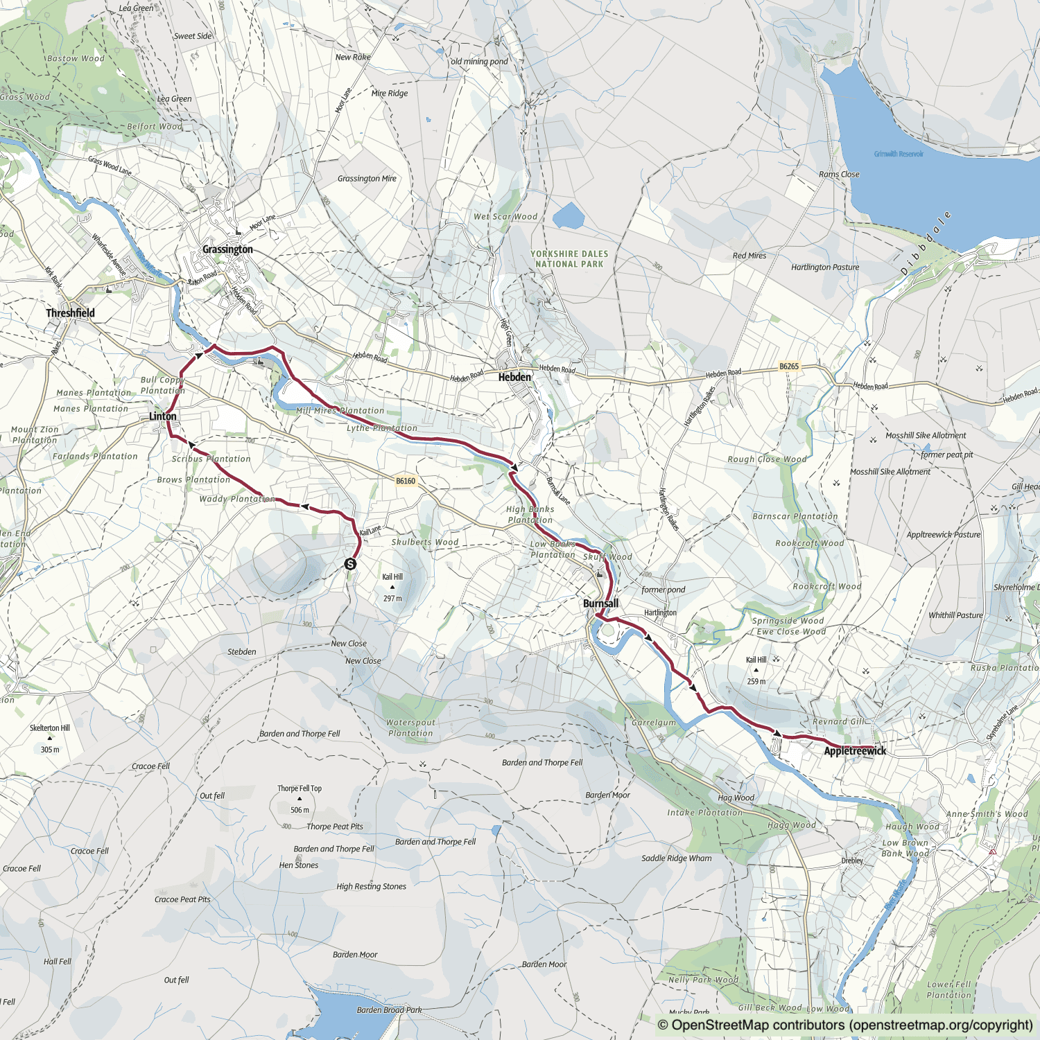
BBC Winter Walks Series 1 Episode 1: Selina Scott’s Thorpe and Appletreewick Walk
Distance: 6½ Miles | Duration: 2¾ Hours | Total Ascent: 472 Feet
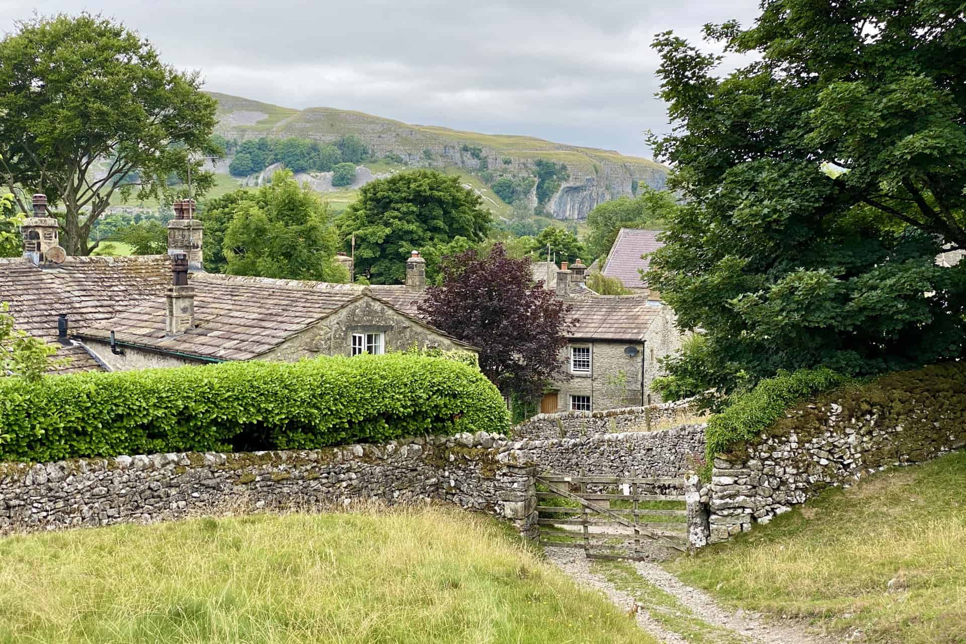
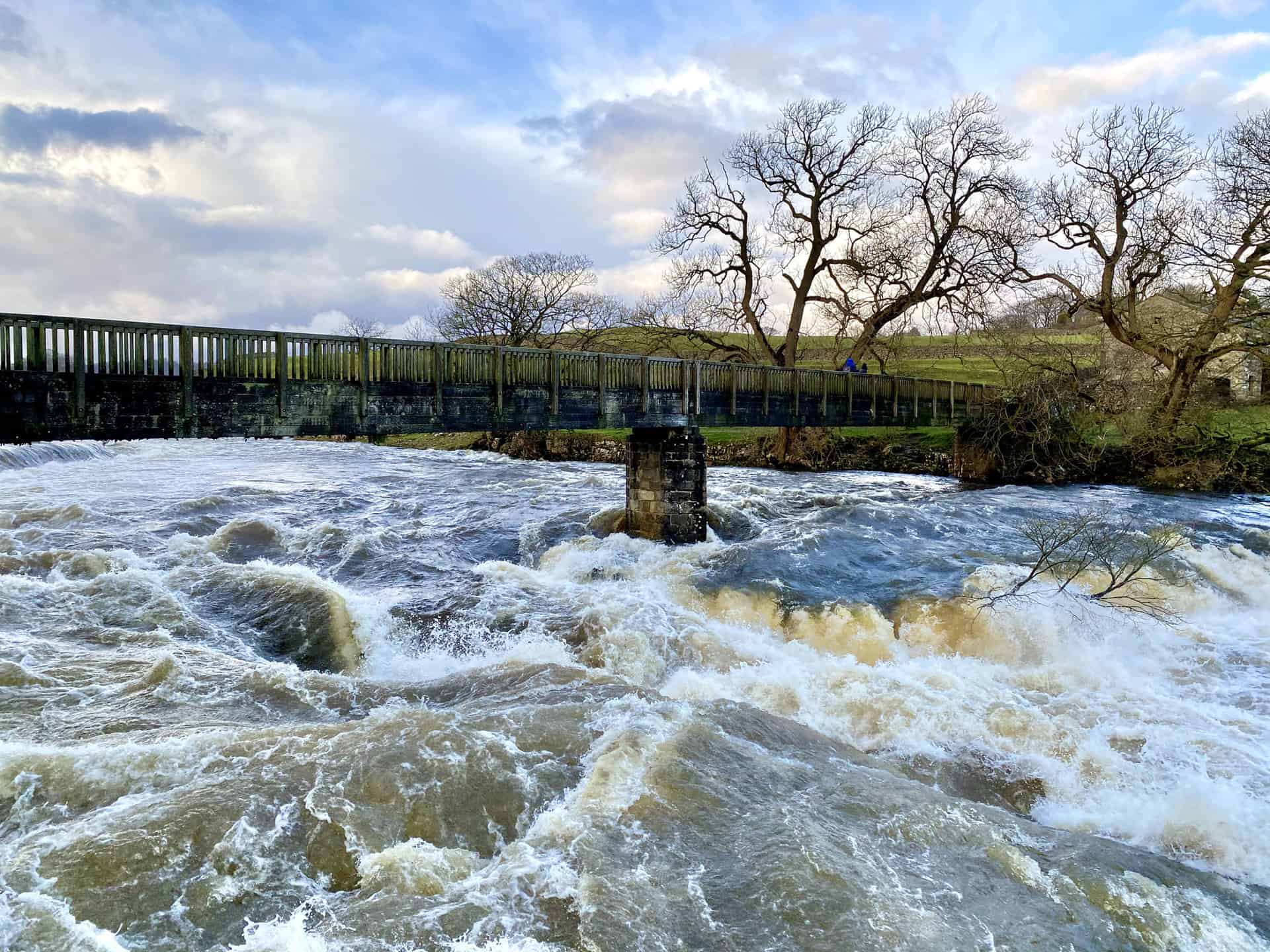
BBC Winter Walks series 1 episode 1 was presented by Selina Scott. Selina’s Thorpe and Appletreewick walk was in Wharfedale in the Yorkshire Dales. Thorpe is 6 miles north of Skipton and 1½ miles south-east of Grassington.
Selina Scott Enjoys a Gentle Walk Around Wharfedale in the Yorkshire Dales
The tranquil sounds of the countryside permeate the air as broadcaster and author Selina Scott savours a leisurely stroll around Wharfedale in the Yorkshire Dales. Venturing through charming villages, enchanting waterways, and awe-inspiring landscapes, Selina provides her unique perspective on this remarkable corner of the Dales. Equipped with a 360-degree camera to document both herself and the surrounding beauty, Selina meanders through the countryside, often immersed in contemplation, pausing only to converse, recite poetry, and reflect. Throughout her journey, she uncovers tales of exceptional philanthropy, encounters fellow walkers and a fisherman, and concludes her adventure by enjoying local ale in a pub celebrated for its ferret racing.
Selina’s Thorpe and Appletreewick Walk Route
Visit either the OS Maps website or the Outdooractive website to view this walking route in greater detail. Both platforms offer a range of features, including the ability to print the route, download it to your device, and export the route as a GPX file. You can also watch a 3D fly-over and share the route on social media.
Recommended Ordnance Survey Map
The best map to use on this walk is the Ordnance Survey map of the Yorkshire Dales Southern & Western Area, reference OS Explorer OL2, scale 1:25,000. It clearly displays footpaths, rights of way, open access land and vegetation on the ground, making it ideal for walking, running and hiking. The map can be purchased from Amazon in either a standard, paper version or a weatherproof, laminated version, as shown below.
Standard Version
View on the BBC website: https://www.bbc.co.uk/programmes/m000qfrw
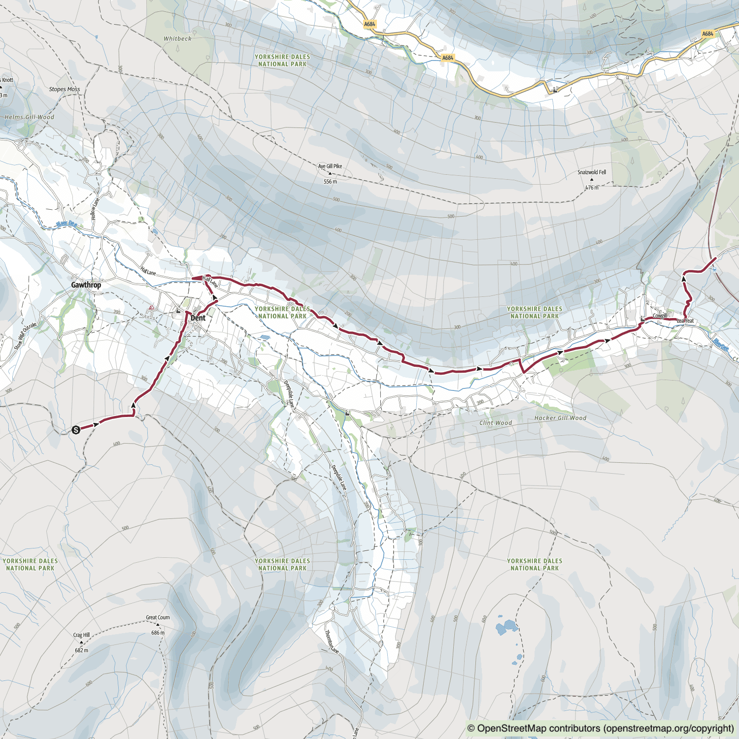
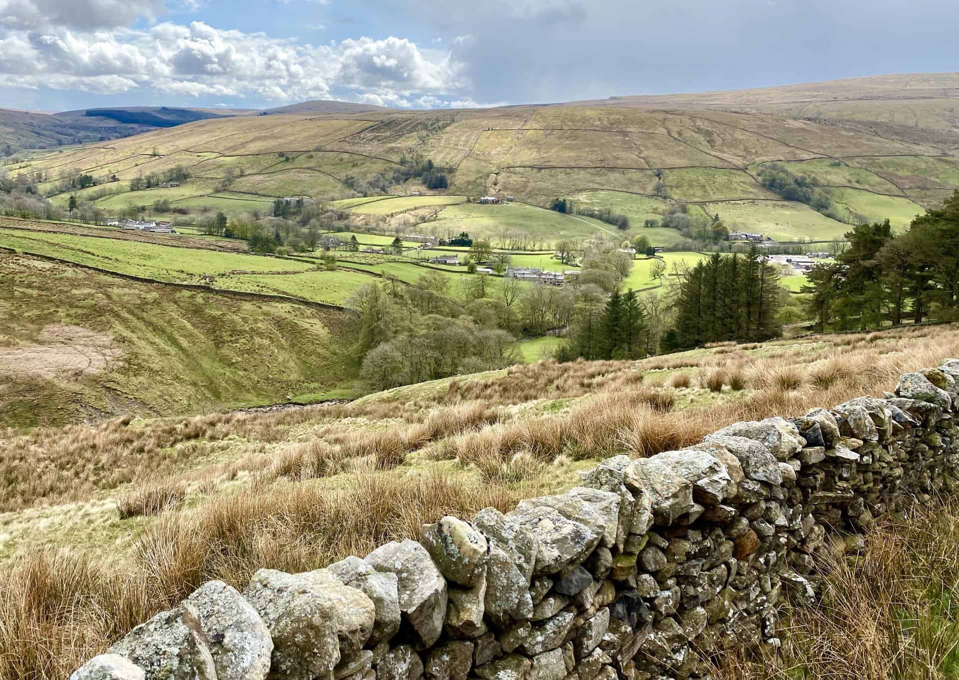
BBC Winter Walks Series 1 Episode 2: Lemn Sissay’s Flinter Gill and Dent Station Walk
Distance: 6½ Miles | Duration: 3 Hours | Total Ascent: 1017 Feet
BBC Winter Walks series 1 episode 2 was presented by Lemn Sissay. Lemn’s Flinter Gill and Dent Station walk was in Dentdale in the Yorkshire Dales. Flinter Gill is 1 mile south-west of Dent and 5 miles south-east of Sedbergh.
Lemn Sissay Journeys Into a World of Snow-Capped Hills, Blue Skies and Birdsong
The idyllic landscape of Cumbria’s Dentdale provides the backdrop for Lemn Sissay’s captivating exploration, filled with snow-topped hills, cerulean skies, and melodious birdsong. Commencing high on the moorlands above Dent village and equipped with a 360-degree camera, Lemn treads along ancient drovers’ routes and the old postman’s path, encountering breathtaking winter vistas at every turn. Engaging with locals, such as a farmer with a penchant for collecting vintage tractors and a solitary bagpiper, Lemn is invigorated by the landscape and contemplates the profound impact of being immersed in nature. Following a demanding ascent to England’s loftiest mainline railway station, Dent, Lemn recognises the importance of dedicating time to traverse and discover the countryside further.
Lemn’s Flinter Gill and Dent Station Walk Route
Visit either the OS Maps website or the Outdooractive website to view this walking route in greater detail. Both platforms offer a range of features, including the ability to print the route, download it to your device, and export the route as a GPX file. You can also watch a 3D fly-over and share the route on social media.
Recommended Ordnance Survey Map
The best map to use on this walk is the Ordnance Survey map of the Yorkshire Dales Southern & Western Area, reference OS Explorer OL2, scale 1:25,000. It clearly displays footpaths, rights of way, open access land and vegetation on the ground, making it ideal for walking, running and hiking. The map can be purchased from Amazon in either a standard, paper version or a weatherproof, laminated version, as shown below.
Standard Version
View on the BBC website: https://www.bbc.co.uk/programmes/m000qftx
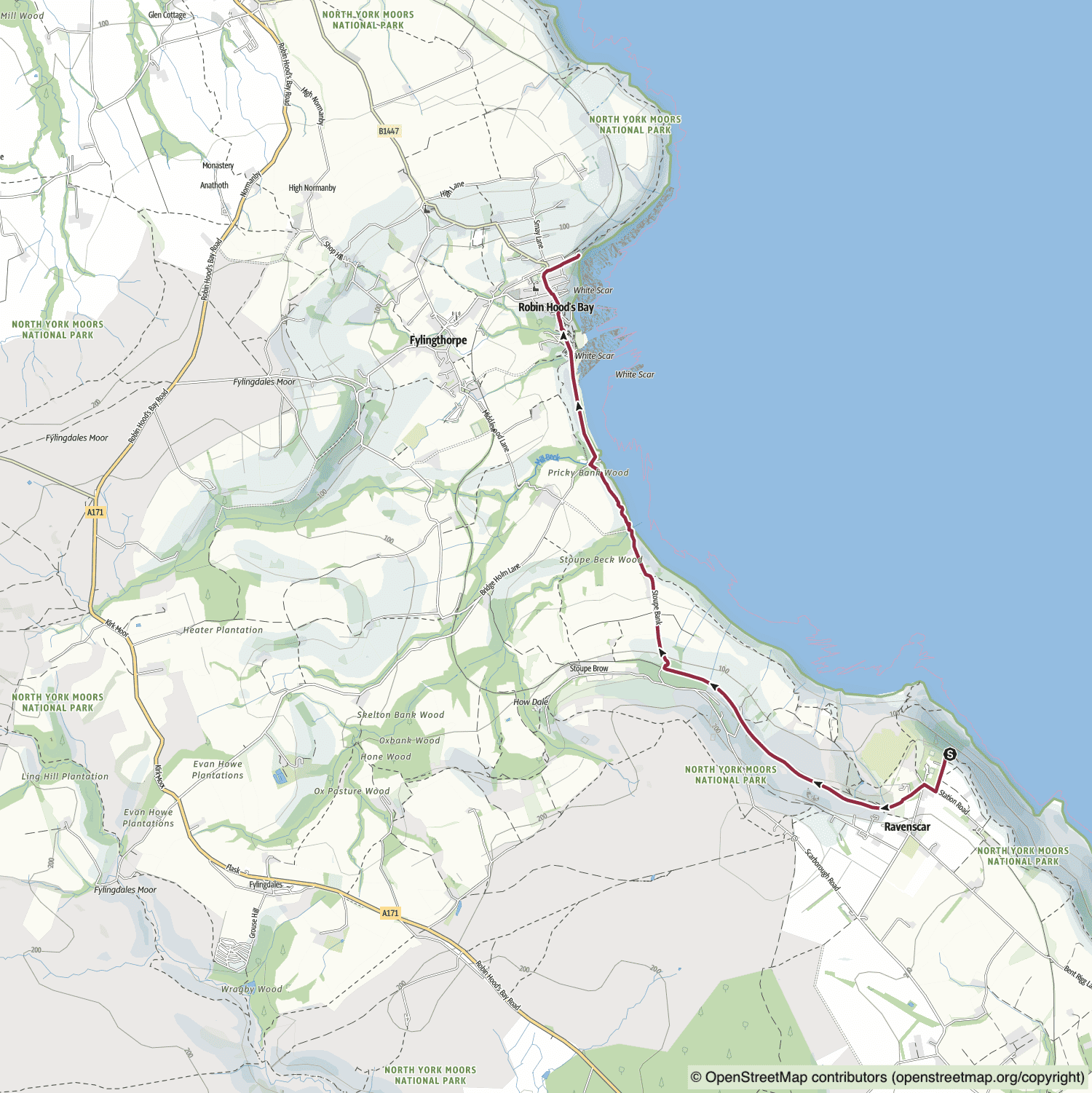
BBC Winter Walks Series 1 Episode 3: Simon Armitage’s Ravenscar and Robin Hood’s Bay Walk
Distance: 4 Miles | Duration: 2 Hours | Total Ascent: 451 Feet
BBC Winter Walks series 1 episode 3 was presented by Simon Armitage. Simon’s Ravenscar and Robin Hood’s Bay walk was along the Yorkshire Coast in the North York Moors. Ravenscar is 8½ miles south-east of Whitby and 9 miles north-west of Scarborough.
Poet Laureate Simon Armitage Rambles Along Yorkshire’s Frontier With the North Sea
A coastal promenade forms the backdrop for Poet Laureate Simon Armitage’s meandering journey along Yorkshire’s captivating and historic boundary with the North Sea. Starting in Ravenscar, Simon Armitage embarks along the old Cinder Track, a now-defunct railway line. Equipped with a 360-degree camera, he strolls past former quarries and brickworks before undertaking a beach walk from Boggle Hole to the picturesque Robin Hood’s Bay. Simon witnesses firsthand the repercussions of coastal erosion and engages with farmers and locals who live and work by the sea. He concludes his expedition with a seaside pint of locally brewed ale.
Simon’s Ravenscar and Robin Hood’s Bay Walk Route
Visit either the OS Maps website or the Outdooractive website to view this walking route in greater detail. Both platforms offer a range of features, including the ability to print the route, download it to your device, and export the route as a GPX file. You can also watch a 3D fly-over and share the route on social media.
Recommended Ordnance Survey Map
The best map to use on this walk is the Ordnance Survey map of the North York Moors Eastern Area, reference OS Explorer OL27, scale 1:25,000. It clearly displays footpaths, rights of way, open access land and vegetation on the ground, making it ideal for walking, running and hiking. The map can be purchased from Amazon in either a standard, paper version or a weatherproof, laminated version, as shown below.

View on the BBC website: https://www.bbc.co.uk/programmes/m000qd6r
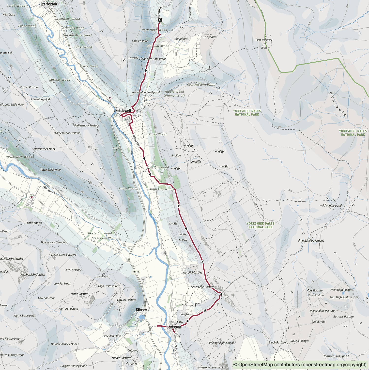
BBC Winter Walks Series 1 Episode 4: Sayeeda Warsi’s Kettlewell and Conistone Walk
Distance: 6 Miles | Duration: 2¾ Hours | Total Ascent: 550 Feet
BBC Winter Walks series 1 episode 4 was presented by Sayeeda Warsi. Sayeeda’s Kettlewell and Conistone walk was in Wharfedale in the Yorkshire Dales. Kettlewell is 6 miles north of Grassington and 12½ miles south-east of Hawes.
Yorkshire Peer Sayeeda Warsi Takes Time Out to Seek Peace and Calm in the Dales
Complemented by the serene soundscape of the vast outdoors, Yorkshire peer Sayeeda Warsi steps away from her political life to find tranquillity in the Dales. During her stroll through Wharfedale, the former government minister mingles with villagers in Kettlewell, a farmer in the throes of lambing preparation, and a long-distance fell runner. Sayeeda uncovers a mesmerising, hidden landscape that feels almost other-worldly. Documenting herself and her surroundings with a 360-degree camera, she ambles through the stunning countryside, finding inspiration at every turn.
Sayeeda’s Kettlewell and Conistone Walk Route
Visit either the OS Maps website or the Outdooractive website to view this walking route in greater detail. Both platforms offer a range of features, including the ability to print the route, download it to your device, and export the route as a GPX file. You can also watch a 3D fly-over and share the route on social media.
Recommended Ordnance Survey Map
The best map to use on this walk is the Ordnance Survey map of the Yorkshire Dales Southern & Western Area, reference OS Explorer OL2, scale 1:25,000. It clearly displays footpaths, rights of way, open access land and vegetation on the ground, making it ideal for walking, running and hiking. The map can be purchased from Amazon in either a standard, paper version or a weatherproof, laminated version, as shown below.
Standard Version
View on the BBC website: https://www.bbc.co.uk/programmes/m000qzmy
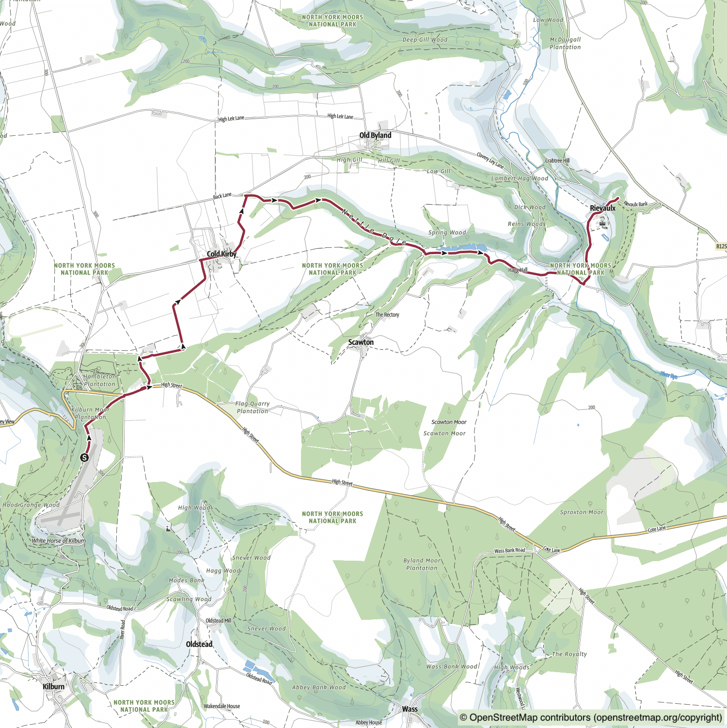
BBC Winter Walks Series 1 Episode 5: Richard Coles’ Sutton Bank and Rievaulx Abbey Walk
Distance: 6½ Miles | Duration: 2¾ Hours | Total Ascent: 249 Feet
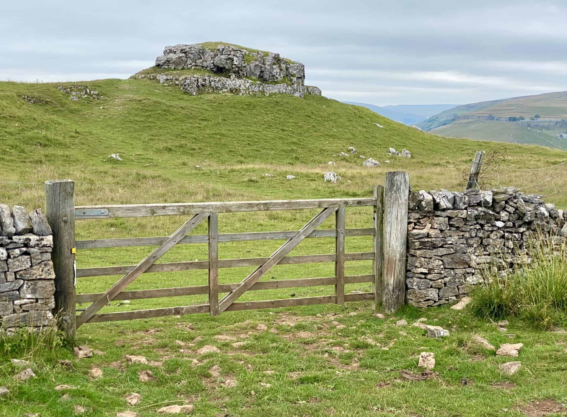
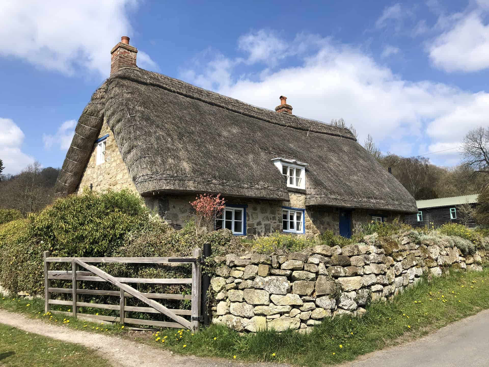
BBC Winter Walks series 1 episode 5 was presented by Richard Coles. Richard’s Sutton Bank and Rievaulx Abbey walk was in the Cold Kirby and Old Byland area in the North York Moors. Sutton Bank is 5½ miles east of Thirsk and 6 miles west of Helmsley.
The North York Moors Provide a Picturesque Setting for Richard Coles on a Winter Walk
The North York Moors presents a picturesque backdrop for Reverend Richard Coles’ winter stroll through this historic landscape. Embarking from the iconic Sutton Bank, famed for its panoramic views, Richard guides viewers through a countryside sculpted by centuries of change, coloured by conflict, mining, and religious influences. Armed with a handheld 360-degree camera, Richard draws inspiration from the vistas and soundscape of his journey, sharing personal reflections en route. Concluding at Rievaulx Abbey, Richard leads viewers through the ruins, providing insightful commentary. Once the site of one of England’s most influential Cistercian monasteries, the location prompts Richard to end his journey with a discourse on the need for quiet contemplation.
Richard’s Sutton Bank and Rievaulx Abbey Walk Route
Visit either the OS Maps website or the Outdooractive website to view this walking route in greater detail. Both platforms offer a range of features, including the ability to print the route, download it to your device, and export the route as a GPX file. You can also watch a 3D fly-over and share the route on social media.
Recommended Ordnance Survey Map
The best map to use on this walk is the Ordnance Survey map of the North York Moors Western Area, reference OS Explorer OL26, scale 1:25,000. It clearly displays footpaths, rights of way, open access land and vegetation on the ground, making it ideal for walking, running and hiking. The map can be purchased from Amazon in either a standard, paper version or a weatherproof, laminated version, as shown below.
View on the BBC website: https://www.bbc.co.uk/programmes/m000qfw1
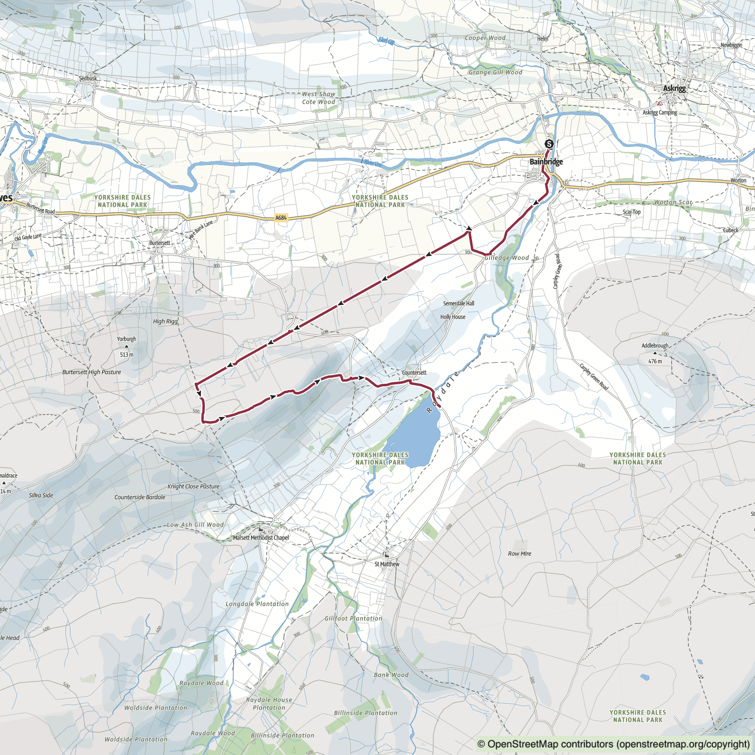
BBC Winter Walks Series 2 Episode 1: Amanda Owen’s Bainbridge and Semer Water Walk
Distance: 5½ Miles | Duration: 2¾ Hours | Total Ascent: 1121 Feet
BBC Winter Walks series 2 episode 1 was presented by Amanda Owen. Amanda’s Bainbridge and Semer Water walk was in Wensleydale and Raydale in the Yorkshire Dales. Bainbridge is 4 miles east of Hawes and 11½ miles west of Leyburn.
Farmer Amanda Owen Walks Across the Dales and Describes Her Love for Life in Yorkshire
The ‘Yorkshire Shepherdess’, Amanda Owen, ventures into familiar landscapes as she traverses hills and fields through Wensleydale and Raydale during her winter ramble. Following ancient pathways first established by the Romans, Amanda encounters fellow sheep farmers, exchanging insights on their common vocation. As she roams across the Dales, armed with her 360-degree camera, she narrates the realities of life working and residing within this landscape. She takes her time to resonate with the gentle sounds and views of the undulating hills, discovering fossils within the stones underfoot. Journeying over the Dales, she descends to Semer Water, culminating her walk on the pebbled banks as the water gently laps at her feet.
Amanda’s Bainbridge and Semer Water Walk Route
Visit either the OS Maps website or the Outdooractive website to view this walking route in greater detail. Both platforms offer a range of features, including the ability to print the route, download it to your device, and export the route as a GPX file. You can also watch a 3D fly-over and share the route on social media.
Recommended Ordnance Survey Map
The best map to use on this walk is the Ordnance Survey map of the Yorkshire Dales Northern & Central Area, reference OS Explorer OL30, scale 1:25,000. It clearly displays footpaths, rights of way, open access land and vegetation on the ground, making it ideal for walking, running and hiking. The map can be purchased from Amazon in either a standard, paper version or a weatherproof, laminated version, as shown below.
Standard Version

View on the BBC website: https://www.bbc.co.uk/programmes/m001226k
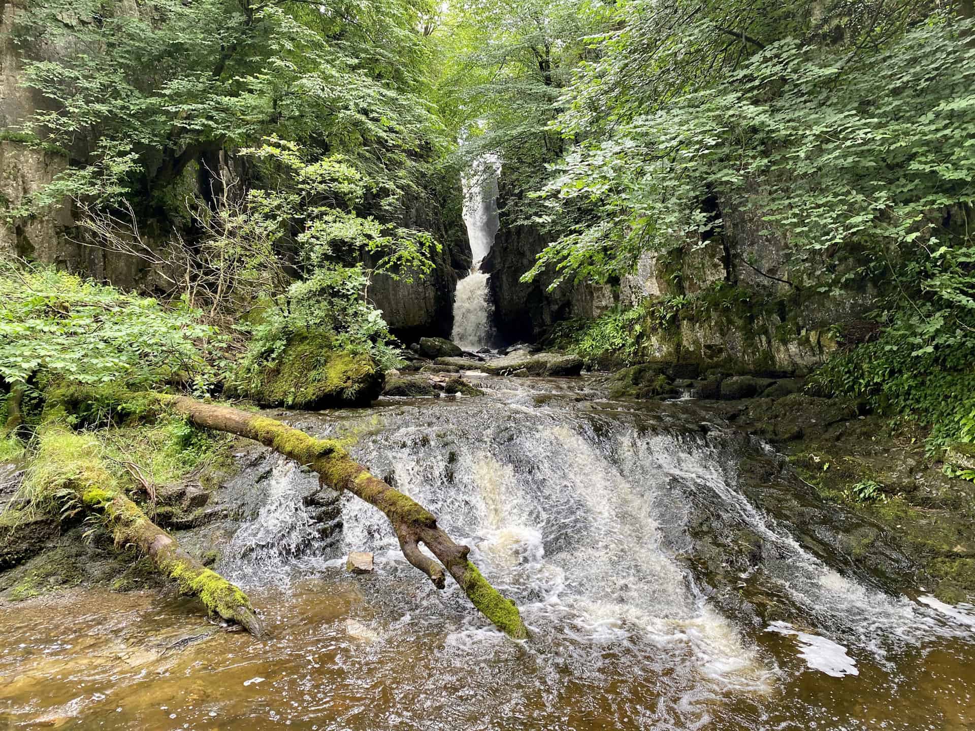
BBC Winter Walks Series 2 Episode 2: Alastair Campbell’s Scaleber Force and Catrigg Force Walk
Distance: 5½ Miles | Duration: 2¾ Hours | Total Ascent: 955 Feet
BBC Winter Walks series 2 episode 2 was presented by Alastair Campbell. Alastair’s Scaleber Force and Catrigg Force walk was in Ribblesdale in the Yorkshire Dales. Scaleber Force is 1½ miles south-east of Settle and 11½ miles north-west of Skipton.
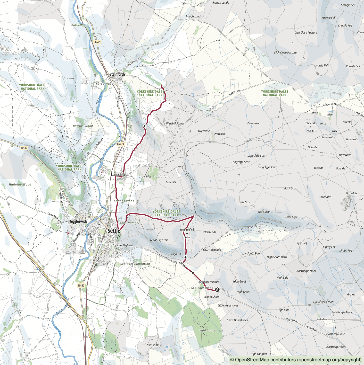
Alastair Campbell Explores the Snow-Covered Hillsides of the Yorkshire Dales
The snow-draped hillsides of Ribblesdale provide the backdrop for Alastair Campbell’s winter trek through the Yorkshire Dales. Neither fog nor snow deter the seasoned political figure as he traverses the county of his birth and upbringing. Beginning at a waterfall situated above the market town of Settle, Alastair ventures into the town, meeting local residents who are also braving the inclement weather. Twisted trees and dry stone walls punctuate his route. The steep slopes and dramatic vistas serve as a reminder to Alastair of nature’s humbling might. Discussing his mental health, Alastair describes the solace he finds in such landscapes, and how spending time within them can aid him in concentrating on life’s true priorities.
Alastair’s Scaleber Force and Catrigg Force Walk Route
Visit either the OS Maps website or the Outdooractive website to view this walking route in greater detail. Both platforms offer a range of features, including the ability to print the route, download it to your device, and export the route as a GPX file. You can also watch a 3D fly-over and share the route on social media.
Recommended Ordnance Survey Map
The best map to use on this walk is the Ordnance Survey map of the Yorkshire Dales Southern & Western Area, reference OS Explorer OL2, scale 1:25,000. It clearly displays footpaths, rights of way, open access land and vegetation on the ground, making it ideal for walking, running and hiking. The map can be purchased from Amazon in either a standard, paper version or a weatherproof, laminated version, as shown below.
Standard Version
View on the BBC website: https://www.bbc.co.uk/programmes/m0012290
BBC Winter Walks Series 2 Episode 3: Kate Bottley’s Jervaulx Abbey and Middleham Castle Walk
Distance: 5½ Miles | Duration: 2½ Hours | Total Ascent: 453 Feet
BBC Winter Walks series 2 episode 3 was presented by Kate Bottley. Kate’s Jervaulx Abbey and Middleham Castle walk was in Coverdale in North Yorkshire. Jervaulx Abbey is 4½ miles south-east of Leyburn and 4½ miles north-west of Masham.
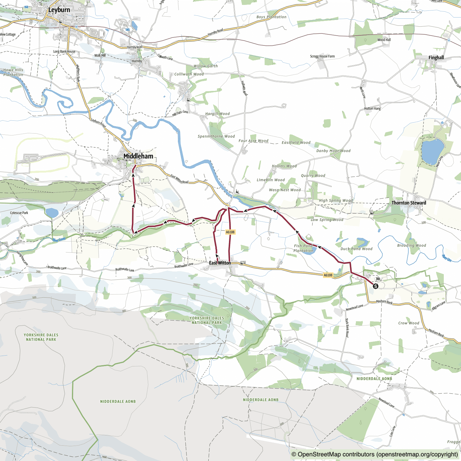
Reverend Kate Bottley Explores the Historic Ruins of Wensleydale on Her Winter Walk
Reverend Kate Bottley immerses herself in the historical ruins and snow-sprinkled landscape of Wensleydale and Coverdale during her winter ramble. Kate embarks on her walk as the sun ascends over the remnants of Jervaulx Abbey in the Nidderdale AONB. Equipped with a 360-degree camera, she meanders along the banks of the River Cover and into the dale sharing its name. While traversing through woodlands, she encounters local residents daring to brave the frosty conditions. Throughout her journey, Kate contemplates her faith and relationships. Her expedition concludes at Middleham Castle, the dilapidated fortress that once served as a childhood residence of Richard III.
Kate’s Jervaulx Abbey and Middleham Castle Walk Route
Visit either the OS Maps website or the Outdooractive website to view this walking route in greater detail. Both platforms offer a range of features, including the ability to print the route, download it to your device, and export the route as a GPX file. You can also watch a 3D fly-over and share the route on social media.
Recommended Ordnance Survey Map
The best map to use on this walk is the Ordnance Survey map of the Yorkshire Dales Northern & Central Area, reference OS Explorer OL30, scale 1:25,000. It clearly displays footpaths, rights of way, open access land and vegetation on the ground, making it ideal for walking, running and hiking. The map can be purchased from Amazon in either a standard, paper version or a weatherproof, laminated version, as shown below.
Standard Version
Recommended Ordnance Survey Map
The best map to use on this walk is the Ordnance Survey map of Northallerton & Thirsk, reference OS Explorer 302, scale 1:25,000. It clearly displays footpaths, rights of way, open access land and vegetation on the ground, making it ideal for walking, running and hiking. The map can be purchased from Amazon in either a standard, paper version or a weatherproof, laminated version, as shown below.
View on the BBC website: https://www.bbc.co.uk/programmes/m00122hp
BBC Winter Walks Series 2 Episode 4: Nihal Arthanayake’s Arnside Pier and Jenny Brown’s Point Walk
Distance: 5 Miles | Duration: 2½ Hours | Total Ascent: 691 Feet
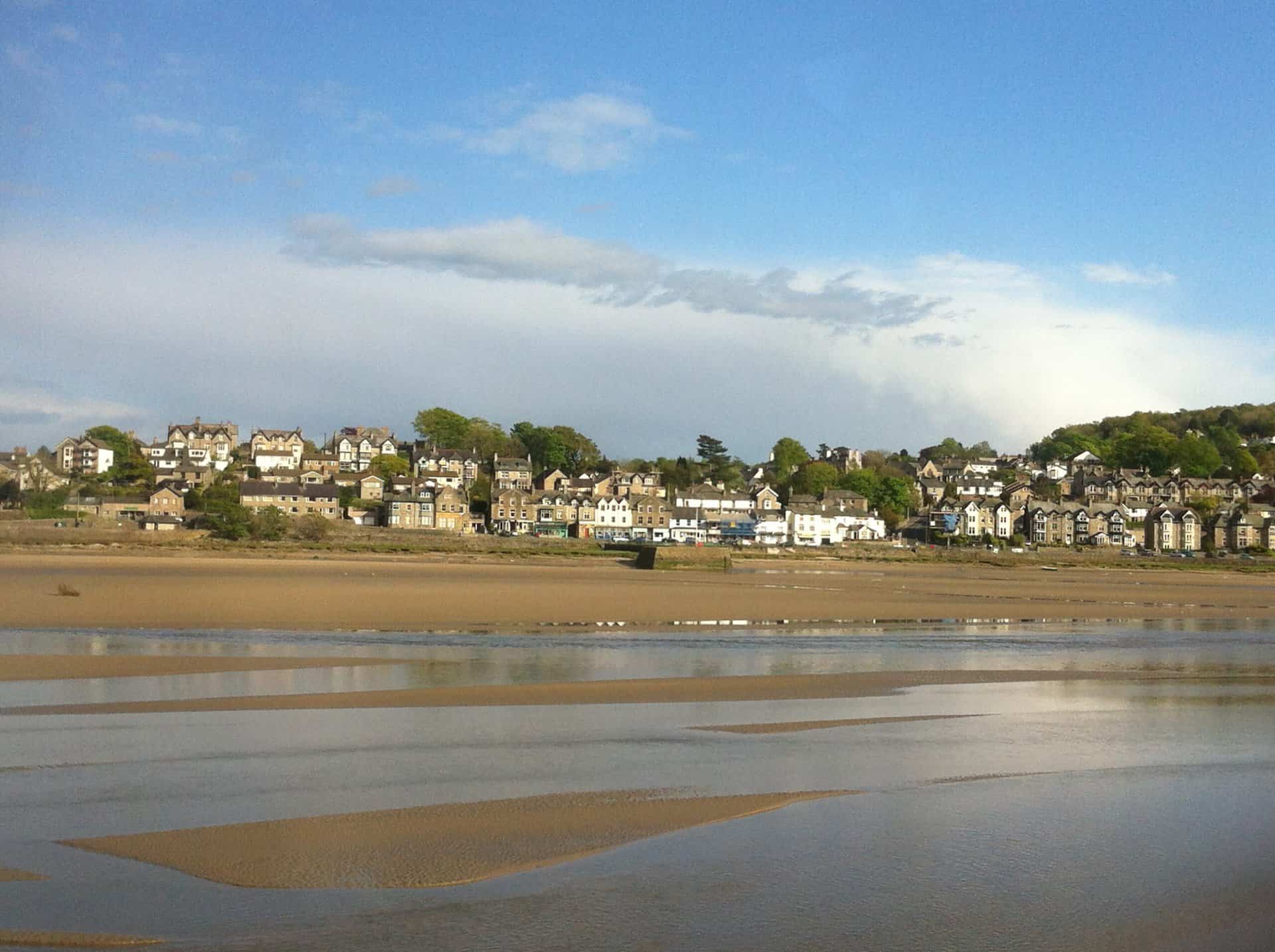
BBC Winter Walks series 2 episode 4 was presented by Nihal Arthanayake. Nihal’s Arnside Pier and Jenny Brown’s Point walk was in the Arnside and Silverdale area of Morecambe Bay. Arnside Pier is 3 miles east of Grange-over-Sands and 10 miles south-west of Kendal.
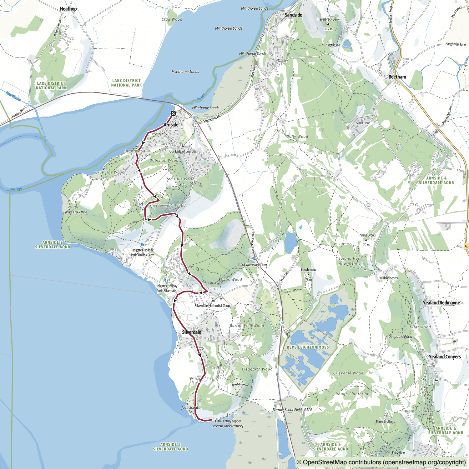
DJ Nihal Arthanayake Enjoys Solitude and Calm by the Coast in Cumbria and Lancashire
Broadcaster and radio DJ, Nihal Arthanayake, explores the coast and countryside surrounding the Cumbria and Lancashire border, encountering local personalities, spectacular vistas, and moments of tranquillity throughout his journey. As a recent settler in the north west, Nihal is eager to uncover the treasures in his vicinity. Embarking from the coastal town of Arnside, and surveying the mudflats of Morecambe Bay, Nihal ventures southward with only his 360-degree camera for company. The quietude and stillness of his walk provides a welcome opportunity to ‘declutter’ his mind and reflect on the value of solitude. Along the way, Nihal passes Arnside Tower and crosses the border into Lancashire. The views from the summit of Arnside Knott and from concealed coves on the Silverdale coast exhibit the beauty of this part of the country, offering Nihal fresh perspectives on his work and relationships.
Nihal’s Arnside Pier and Jenny Brown’s Point Walk Route
Visit either the OS Maps website or the Outdooractive website to view this walking route in greater detail. Both platforms offer a range of features, including the ability to print the route, download it to your device, and export the route as a GPX file. You can also watch a 3D fly-over and share the route on social media.
Recommended Ordnance Survey Map
The best map to use on this walk is the Ordnance Survey map of the Lake District South-Western Area, reference OS Explorer OL6, scale 1:25,000. It clearly displays footpaths, rights of way, open access land and vegetation on the ground, making it ideal for walking, running and hiking. The map can be purchased from Amazon in either a standard, paper version or a weatherproof, laminated version, as shown below.
Standard Version
View on the BBC website: https://www.bbc.co.uk/programmes/m00122hx
Amazon’s Top Walking Boots: Four Standout Choices for Men and Women
For walking and hiking, the right boots are essential for both comfort and safety. While Amazon boasts a wide range, certain boots emerge as top-sellers. From those, here are four I personally favour. As an Amazon affiliate, I may earn a small commission from any purchases made through the links provided. This helps support the upkeep of this website. Rest assured, you won’t pay a penny extra, but your purchase will contribute to keeping my site running smoothly. Happy walking!

Berghaus Men’s Hillmaster II Gore-Tex Walking Boots
These fully waterproof leather walking boots feature a Gore-Tex lining, ensuring no water enters whilst allowing feet to breathe and stay cool. Made from full-grain leather, they promise unmatched durability and comfort. The boots come with memory foam tongues and cuffs that mould to your feet for a tailored fit, and the Vibram Hillmaster outsoles offer confidence on challenging terrains.

Salewa Men’s Mountain Trainer Mid Gore-Tex Walking Boots
Made from durable suede and abrasion-resistant textile, these men’s hiking boots are both lightweight and sturdy. The upper material is enhanced by a 360° full rubber sheath. Their dual-layer midsole with Bilight technology ensures ergonomic cushioning and grip, especially on extended hikes. The Vibram Wrapping Thread Combi outsoles allow a natural walking feel, and the Gore-Tex lining provides waterproofing, breathability, and optimal weather protection. Furthermore, the patented Salewa 3F system ensures flexibility, a secure heel grip, and a blister-free fit.

Berghaus Women’s Supalite II Gore-Tex Walking Boots
Specially designed for women, these hiking boots offer waterproofing and breathability, thanks to their Gore-Tex lining. Crafted from full-grain abrasion-resistant leather, they’re durable enough for the toughest hikes. The Supalite soles ensure stability and traction, and the EVA midsoles add comfort for extended walks.

Merrell Women’s Moab 3 Mid Gore-Tex Walking Boots
These hiking boots incorporate a Gore-Tex waterproof membrane, blending breathability with superior waterproof performance. The combination of pigskin leather and mesh on the uppers, along with the suede outer material, ensure durability and style. Enhancements include 100% recycled laces, webbing, and mesh lining. Additionally, bellows tongues, protective toe caps, and Vibram TC5+ rubber soles ensure protection and ease on any terrain.