ADVERTISEMENT
The Views and Riverside Scenery That Make This Richmond Walk Special
Start your Richmond walk in the town centre, parking in Nuns Close Car Park, a pay and display car park with toilet facilities. Leave by the car park’s main exit for vehicles, which brings you out onto Hurgill Road with Richmondshire Cricket Club opposite. Turn right and walk down Hurgill Road to reach Victoria Road, the A6108. Turn right onto Victoria Road and follow it to the roundabout, then turn right again, signposted to Leyburn and Reeth. As the main road bends to the left and becomes Reeth Road, turn right onto Westfields and begin walking uphill.
Westfields also forms part of the Coast to Coast Path, and you’ll see several signposts confirming the route as you climb. After the last of the houses the road narrows, so keep heading straight ahead along the tarmac lane. You’ll soon reach a signpost, where you continue straight on, signposted Coast to Coast Path and public bridleway to Applegarth. Keep following the track ahead past Whitcliffe Farm, ignoring any side paths to the left and right. At High Leases the tarmac lane gives way to a stony track, and you simply carry straight on, continuing through Whitecliffe Wood for half a mile.
You’ll emerge from the trees into open countryside, with Whitcliffe Scar rising above you on the right. Continue through the meadowland beneath the scar. As you approach the farm at East Applegarth, a signpost confirms you’re still on the Coast to Coast Path and public bridleway to Applegarth. After the farm you’ll reach a narrow tarmac lane, which you cross before continuing on the same route. At Low Applegarth you’ll meet another narrow tarmac lane, which you again cross straight over, still following Wainwright’s Coast to Coast Path. Shortly afterwards you’ll reach a further signpost. This is where you leave the Coast to Coast Path, turning left onto the public footpath that drops down towards the River Swale.
ADVERTISEMENT
Follow the grassy path downhill, then bear left, effectively making a U-turn around the farm at Low Applegarth. Continue across the fields down towards the river, where yellow public footpath waymarker arrows guide you. When you reach the banks of the Swale, follow the grassy path across a broad open field, veering slightly away from the water. Return to the river and follow the riverside path for a short while, then cross another broad open meadow as the path again moves away from the bank. Reach the river one final time, pass through a gate and enter the woodland. Follow the stony track uphill through the trees. At Lownethwaite Farm, just before the entrance to the private property, look out for the footpath on the left through a metal kissing gate. This path bypasses the farm to join a concrete lane, where you turn left. Follow the concrete lane all the way down to the main road, which is Reeth Road, the A6108. Reeth Road marks the halfway point of your Richmond walk.
Cross the road to pick up the public footpath directly opposite and follow it through the woods. Keep left here to reach a picnic area and Round Howe Car Park. At the far end of the car park, turn right and use the footbridge to cross the River Swale. On the other side, turn left and follow the path through Hudswell Woods. When the path splits, take the right-hand fork, which is a public footpath. Follow it along the right-hand side of a large grassy meadow, with the edge of the woodland on your right. As you leave the meadow and start to enter a smaller field, the path veers right through some gates and back into the woods. Follow this woodland path uphill through the trees. The River Swale is now on your left, down in the valley below. Continue for half a mile, crossing a footbridge and then descending some steps, to reach the main road at Green Bridge. Turn left here to cross Green Bridge over the River Swale.
Immediately after the bridge, take the road on the right, Riverside Road, and follow it beside the River Swale, beneath the walls of Richmond Castle, all the way to the car park at Richmond Falls. At the far end of the car park, in the right-hand corner, follow the path signposted to The Station. Walk through the Richmond Falls picnic area and keep to the tarmac path, which leads across a large grassy parkland known as The Batts to reach the main road at the northern end of Mercury Bridge. Turn right and cross the bridge, signposted to The Station, then turn left and walk into The Station.
ADVERTISEMENT
Walk past the front of the restored Victorian station buildings and continue straight ahead. Follow a paved path down to a small cobbled road, cross it and pick up the path directly opposite, signposted Easby and Catterick Garrison. This is a wide, well-defined gravel path through the woodland, following the route of a disused railway line, and it’s the start of the Easby Loop, which forms the final part of the Richmond walk. Continue along the old railway with the trees arching overhead for just under a mile, then use the footbridge to cross the River Swale. On the other side, turn left, signposted to Easby, and follow the wide gravel path with the dry stone wall on your right and the River Swale on your left. Continue for about a quarter of a mile to reach St Agatha’s Church ahead of you.
Turn left and follow the tarmac path to Easby Abbey. Carry on past the abbey on your right, then continue through the grounds of a property called Abbey Mill. Cross a small pebbled car park and, on the far side, pick up the footpath beside the dry stone wall. Follow it along the edge of a large meadow, then take the footpath as it bends left back into the woodland. Continue beside the dry stone wall, avoiding the steps that drop down into the River Swale valley on the left. Follow this path for about half a mile, passing the Drummer Boy’s Stone, then carry straight on along the widening track. Keep following it all the way to the high wall of the church graveyard, then turn left to reach the main road, back at the northern end of Mercury Bridge where you crossed earlier.
At the main road, turn right and head uphill, signposted to Market Place. Keep to the main road, Station Road, and continue uphill, passing the church of St Mary the Virgin on your right and North Yorkshire Council’s Mercury House on your left. A little further up, turn left onto Frenchgate, signposted to Market Place. When you reach the cobbled area of Market Place, keep right and follow the path in front of the shops. Continue along the right-hand side of Market Place almost to the top, then turn right onto Finkle Street. Walk along Finkle Street and, at the end, turn right onto Rosemary Lane. At the bottom you’ll reach the main road, the A6108, where a left turn takes you back to Nuns Close Car Park, ending your Richmond walk.
Richmond Walk: Maps and Tools
Visit either the OS Maps website or the Outdooractive website to view this walking route in greater detail. Both platforms offer a range of features, including the ability to print the route, download it to your device, and export the route as a GPX file. You can also watch a 3D fly-over and share the route on social media.
Richmond Walk: Distance, Duration, Statistics
Distance: 9¼ miles
Distance: 14¾ kilometres
Duration: 4¼ hours
Ascent: 835 feet
Ascent: 255 metres
Type: Circular walk
ADVERTISEMENT
Recommended Ordnance Survey Map
The best map to use on this walk is the Ordnance Survey map of Darlington & Richmond, reference OS Explorer 304, scale 1:25,000. It clearly displays footpaths, rights of way, open access land and vegetation on the ground, making it ideal for walking, running and hiking. The map can be purchased from Amazon in either a standard, paper version or a weatherproof, laminated version, as shown below.
About Richmond
Richmond is a handsome market town in North Yorkshire, set at the point where Swaledale, the upper valley of the River Swale, opens out into the broad lowlands of the Vale of Mowbray. It sits close to the eastern edge of the Yorkshire Dales National Park and has long been a popular gateway for visitors exploring the dales, which is exactly the sort of countryside you will discover on this Richmond walk.
A Little History
The town was founded in 1071 by Alan Rufus, a Breton nobleman, on land granted to him by William the Conqueror. It was known at first as Hindrelag, but took the name Richmond from the Old French for “strong hill”, probably after Richemont in Normandy. The name has travelled far in the centuries since, and there are now more than fifty other Richmonds around the world. Richmond Castle was completed in 1086, its keep and walls enclosing the area we now know as the Market Place, and for many years the earldom of Richmond was held, on and off, by the Dukes of Brittany.
One well-known local tale dates from 1606, when a draper named Robert Willance was out hunting on Whitcliffe Scar. A thick mist came down, his horse bolted over the edge of the cliff and fell more than two hundred feet to the valley below. Remarkably, Willance survived with a broken leg, and he later put up a monument on the clifftop in thanks for his escape. He went on to become the first alderman of Richmond in 1608. The town grew prosperous first through the Swaledale wool trade and later on the back of lead mining in nearby Arkengarthdale, and it is from this period that much of Richmond’s fine Georgian architecture dates, seen at its best on Newbiggin and in Frenchgate.
Related Walk: Similar to the Richmond Walk
Ripon Cathedral to Fountains Abbey on a scenic Ripon circular walking route
Geography and Setting
Richmond straddles the eastern border of the Yorkshire Dales National Park, on the edge of Swaledale, which takes its name from the River Swale that flows through the town and is said to be one of the fastest flowing rivers in England. The river is a constant companion on this Richmond walk, and its steep, wooded banks and open riverside meadows give the route much of its character.
Landmarks
At the heart of the town lies the Market Place, one of the largest cobbled market squares in England, where markets have been held since 1093 and a traditional market still takes place each Saturday. At its centre stands the obelisk, built in 1771 to replace an earlier medieval market cross. Rising above it all is Richmond Castle, which overlooks the Swale and draws close to forty thousand visitors a year. Within easy walking distance of the centre are the romantic ruins of Easby Abbey, cared for by English Heritage, while the Little Drummer Boy legend, the folly of Culloden Tower and the tumbling waters of Richmond Falls all add to the town’s appeal. Some of these landmarks feature along this Richmond walk, making the town as rewarding to explore on foot as it is to look at.
Richmond Walk: My Photos
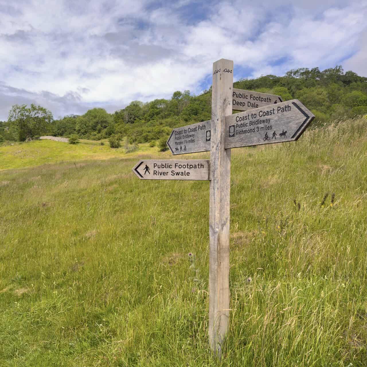
After setting off from Nuns Close Car Park and making my way up Westfields, I began to notice these smart wooden signposts pointing the way along the Coast to Coast Path. This part of my Richmond walk follows the route that Alfred Wainwright devised back in 1973, running for around 190 miles from St Bees on the Cumbrian coast to Robin Hood’s Bay in North Yorkshire, taking in the Lake District, the Yorkshire Dales and the North York Moors along the way. For most of its life the Coast to Coast was an unofficial and largely unsignposted trail, but in March 2026 it was formally opened as one of England’s National Trails, and signs like this one, showing Richmond half a mile away and Applegarth a mile and a half in the other direction, were installed as part of the upgrade.
ADVERTISEMENT
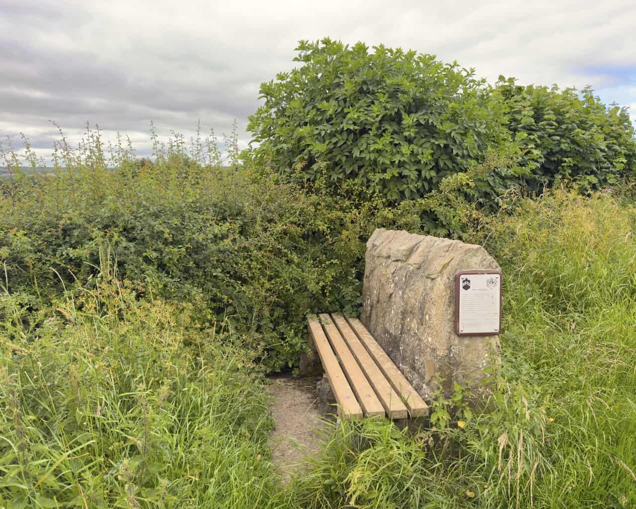
A little further along Westfields I come to a stone bench, set up for Richmond and District Civic Society by the Ragged Robin Conservation and Wildlife Group to mark the Millennium. The plaque carries Alfred Wainwright’s words about the thrilling view of Richmond that lies ahead, describing the town as unlike any other, rich in relics of the past and steeped in a long history that still lingers in its narrow alleys, its quaint buildings and the massive Norman keep of its castle, poised dramatically on a cliff high above the Swale. He calls it a town too good to be by-passed. The plaque also records the Coast to Coast distances from this point, 76½ miles on to Robin Hood’s Bay and 113½ miles back to St Bees Head. I will let you into a small secret, though. Wainwright promised a thrilling view from here, but the hedgerow has grown so tall over the years that today you can settle onto the bench and see very little beyond the leaves in front of you.
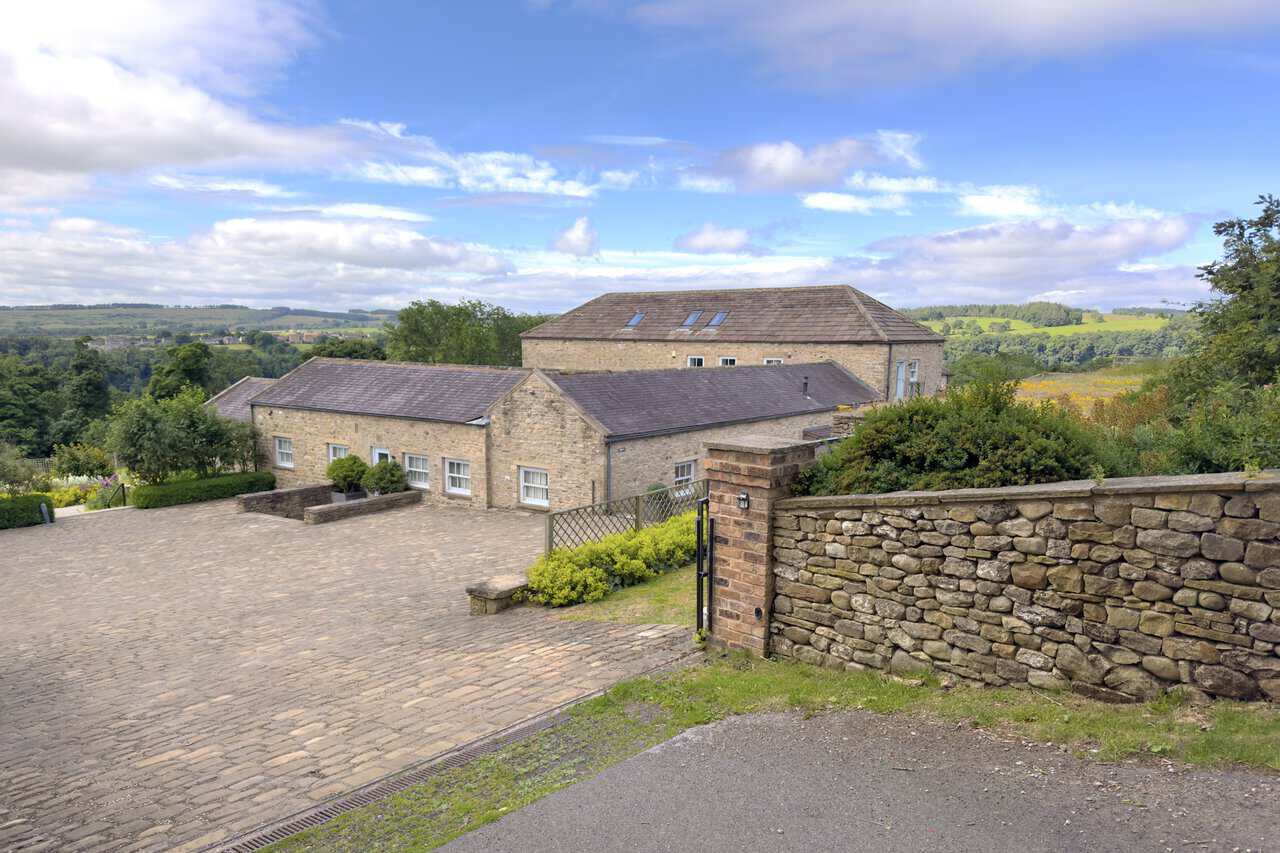
Continuing on, I pass a handsome group of stone buildings at High Leases. Once a working farmstead, they have been beautifully restored, with traditional stone walls, slate roofs and a neat cobbled yard behind a low drystone wall, framed against open countryside with green fields rolling away into the distance beyond.
ADVERTISEMENT
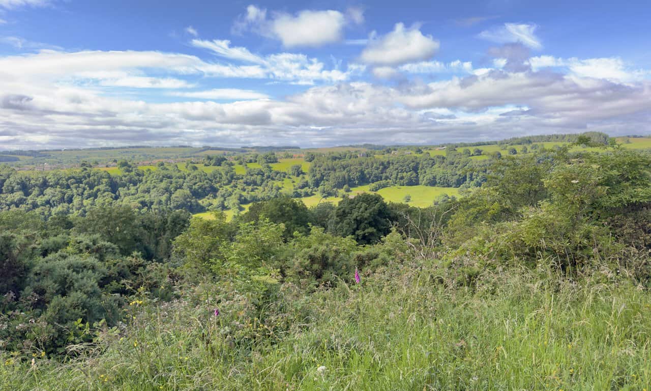
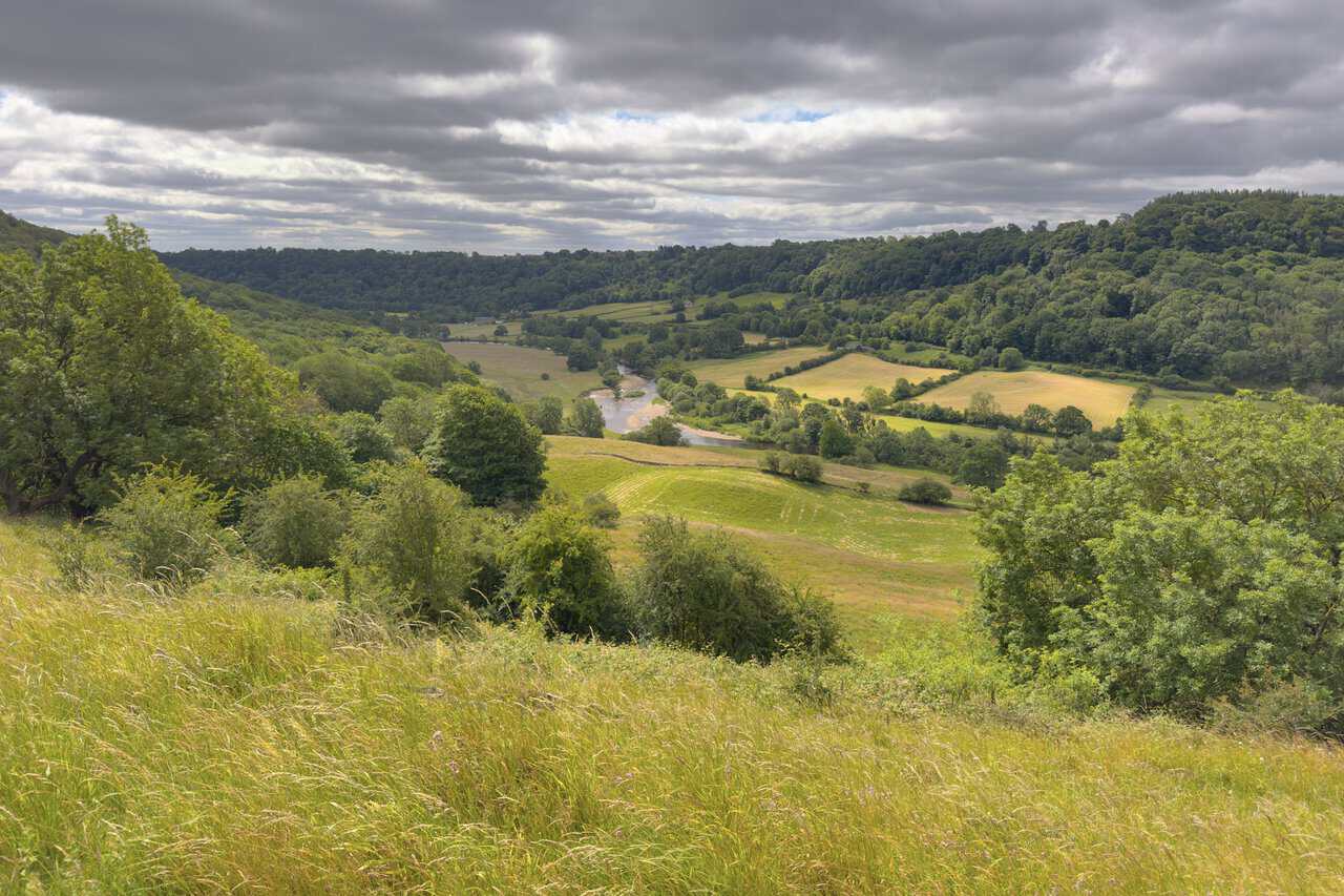
From just past High Leases, it is not long before the views begin to open up to the south, out over the Swale valley and across to the village of Hudswell on the far side. From this high vantage point, wooded slopes tumble away below me towards the hidden river, giving way to a patchwork of green pastures and clumps of woodland that climb the opposite hillside. In the tangle of grasses and bramble in the foreground, I even spot the tall pink spire of a foxglove.
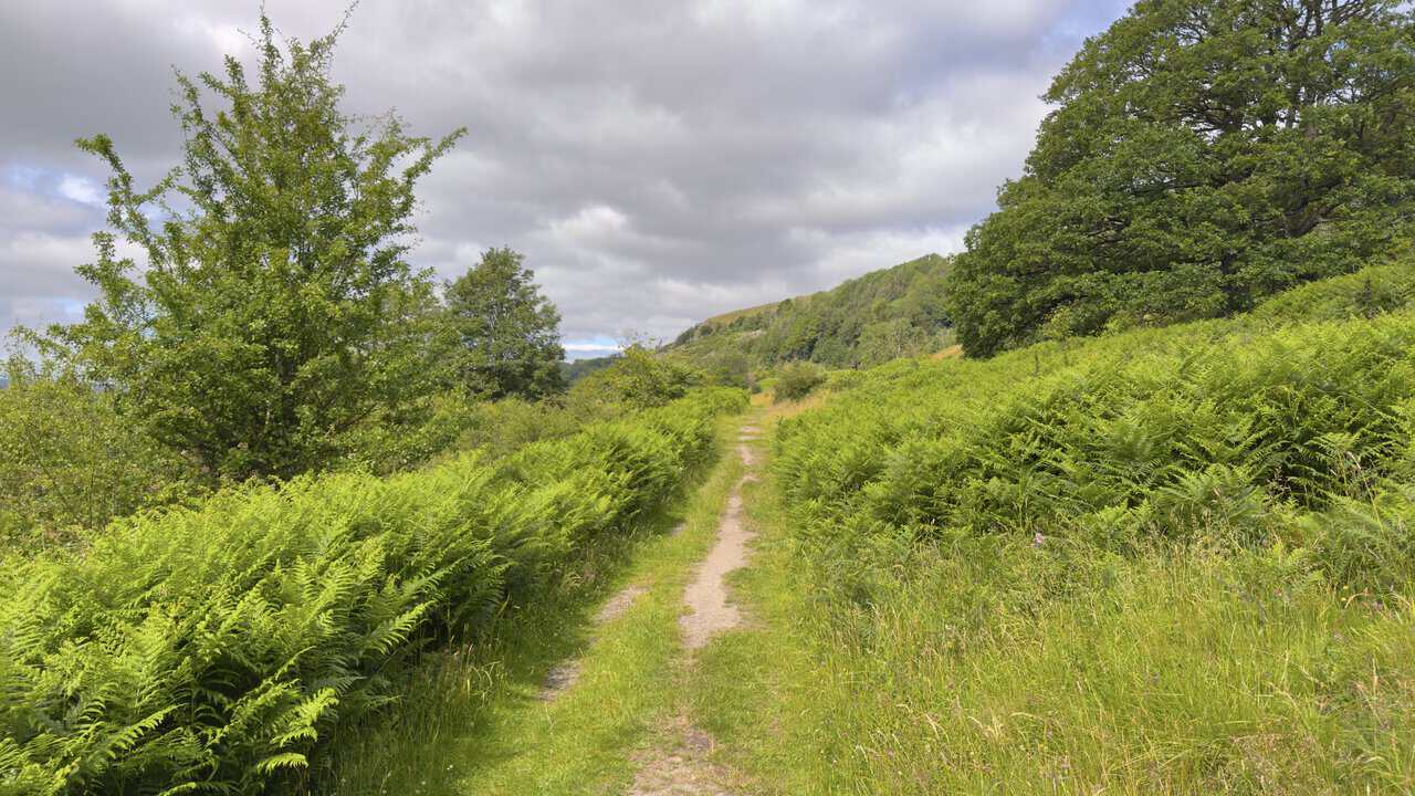
Carrying on through Whitecliffe Wood for half a mile, I emerge from the trees into open countryside, where a footpath leads on through the bracken. Tall green ferns crowd in on both sides, with scattered trees and rough grassland around them. Ahead and to the right, the wooded escarpment of Whitcliffe Scar rises above the path, which I now follow through the meadowland beneath it.
ADVERTISEMENT
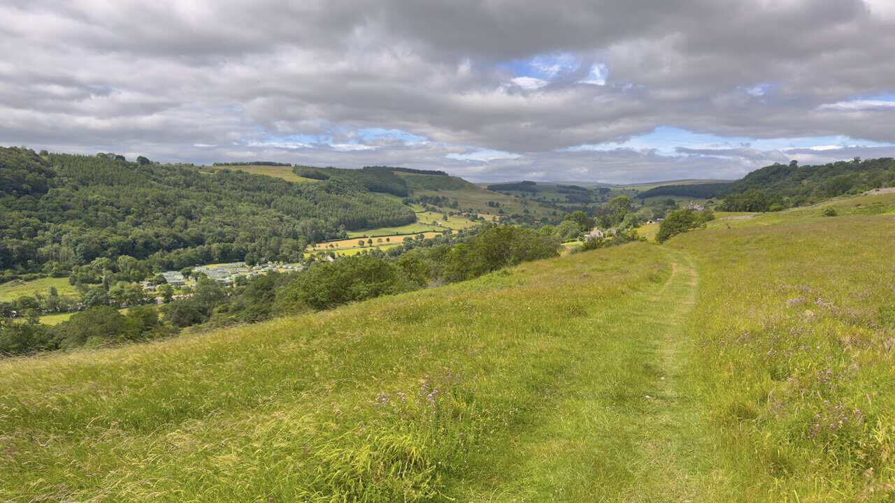
The grassy track carries me on across the meadowland, with fine views opening up ahead and down to my left into the Swale valley. Tucked into the valley bottom sits Swale View Caravan Park, a family-run holiday park on the banks of the river, its caravans and lodges gathered in a loose cluster among the trees. Beyond it, the dale rolls away in a patchwork of woodland, pasture and drystone walls, with the higher moors on the far horizon.
Looking down into the valley over my left shoulder, I catch sight of the River Swale winding its way along the valley floor. From this height the water loops in a broad, lazy curve through a mix of green fields and hedgerows, with wooded slopes rising steeply on either side. It is one of the finest views so far on this stretch of the walk, the river drawing the eye deep into the dale.
ADVERTISEMENT
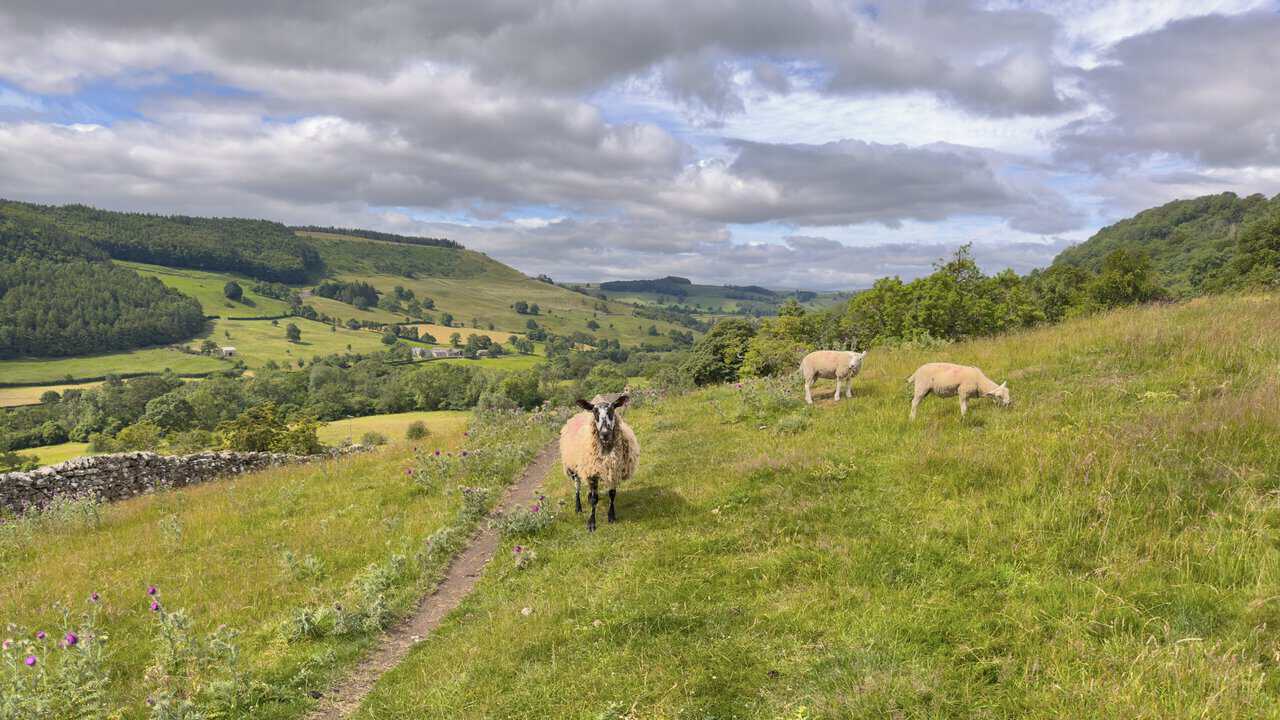
The path leads me on through a lovely stretch of countryside between East Applegarth and Low Applegarth. It threads across open pasture, where sheep marked with red raddle graze among the thistles, one of them stopping to eye me as I pass. A low drystone wall runs along to my left, while ahead the dale opens out in a sweep of green fields, scattered trees and wooded hillsides.
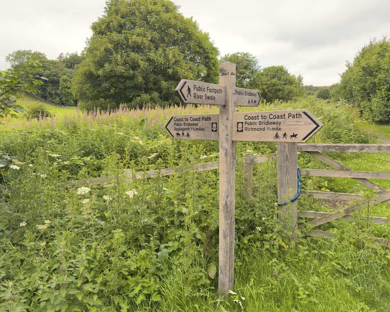
At Low Applegarth I reach the point where I leave the Coast to Coast Path, which carries straight on towards Marske, and back the way I have come towards Richmond, three miles away. Here I turn left and follow the fingerpost pointing downhill to the River Swale. The signpost stands in a meadow of long grass and thistles, with wooded slopes rising behind, and from this spot my Richmond walk begins its gentle descent towards the river.
ADVERTISEMENT
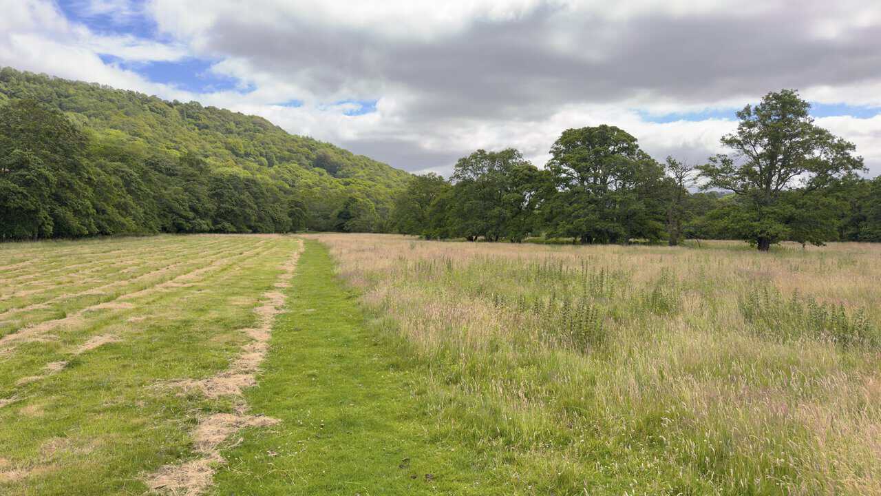
From the signpost I follow the grassy path down across the fields towards the river, with yellow waymarker arrows confirming the way. The path cuts a clear green line through a broad meadow of rougher grass, with mature oaks dotted along the field edge and the wooded slopes of the dale rising beyond. It is easy, gentle walking, and a welcome change after the higher ground earlier on.
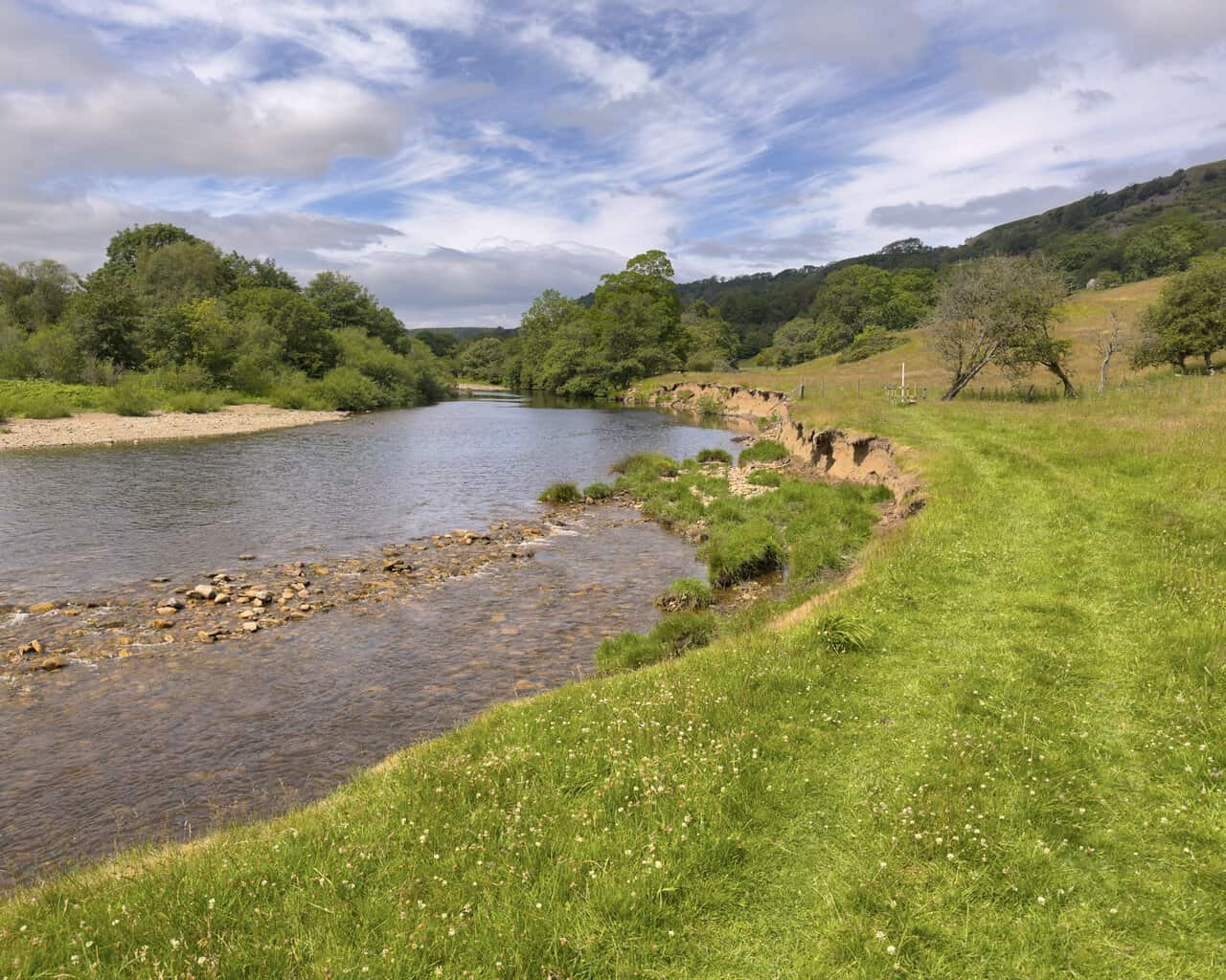
Before long I reach the banks of the River Swale. Here the path runs across a wide open field, keeping a little back from the water for a while. The river has clearly been busy over the years, carving away at the near bank to leave a low earth cliff, with shingle banks and stony shallows exposed along the far side.
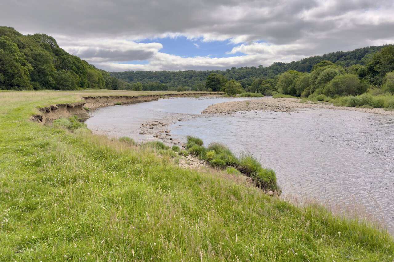
Returning to the river, I follow it for a short stretch, with the water running wide and shallow over its stony bed. Pausing to look back upriver the way I have come, I can see where the current has undercut the bank, leaving a rough line of grass and reeds clinging to the edge where the ground drops away to the shingle below. Wooded hills frame the valley, with a glimpse of higher, craggier ground away to the right.
ADVERTISEMENT
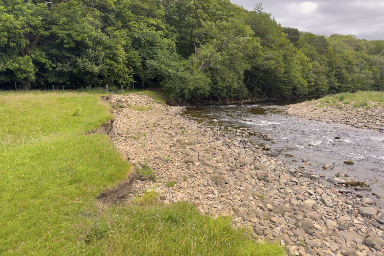
Reaching the river one final time, I come to a broad sweep of shingle where the Swale runs quicker over the stones. A worn path leads along the grass towards a gate at the edge of the trees, where a fence runs down to meet the water. Through the gate, I leave the open riverside behind and enter the shade of the woodland.
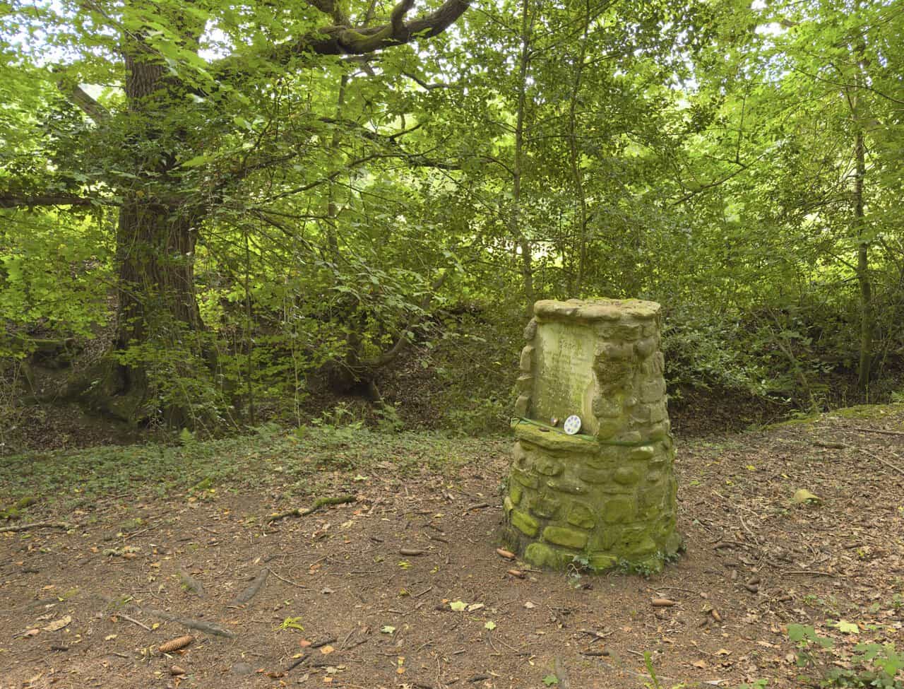
In the woodland, not far from Lownethwaite Farm, I come across a charming little stone memorial set among the trees. Built like a small round cairn of moss-covered stone, it is dedicated to “our kind mistress Jane”, thanking her for “our adventures in Whitcliffe Woods”. The message is signed by her loving dogs and friends, who are each named in turn: Bramble, Poppy, Purdy, Hemp, Tamworth, Tiggy, Meg, Muffy, Rev, Sally, Dandy and Pippy, before ending with a fond “woof, woof”. Someone has left a couple of painted pebbles on its ledge, a nice touch that suggests the spot is still quietly cared for.
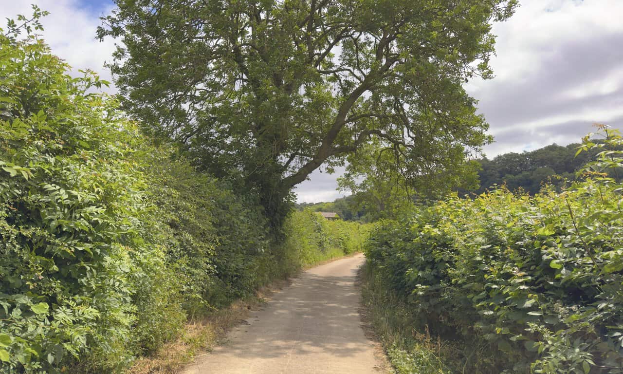
Beyond the memorial, I take the footpath through the metal kissing gate that skirts around Lownethwaite Farm, and join a concrete lane. I follow it downhill, with tall hedgerows and a spreading tree arching over the way. Ahead, the lane runs on towards the main road at the bottom, the halfway point of my Richmond walk.
ADVERTISEMENT
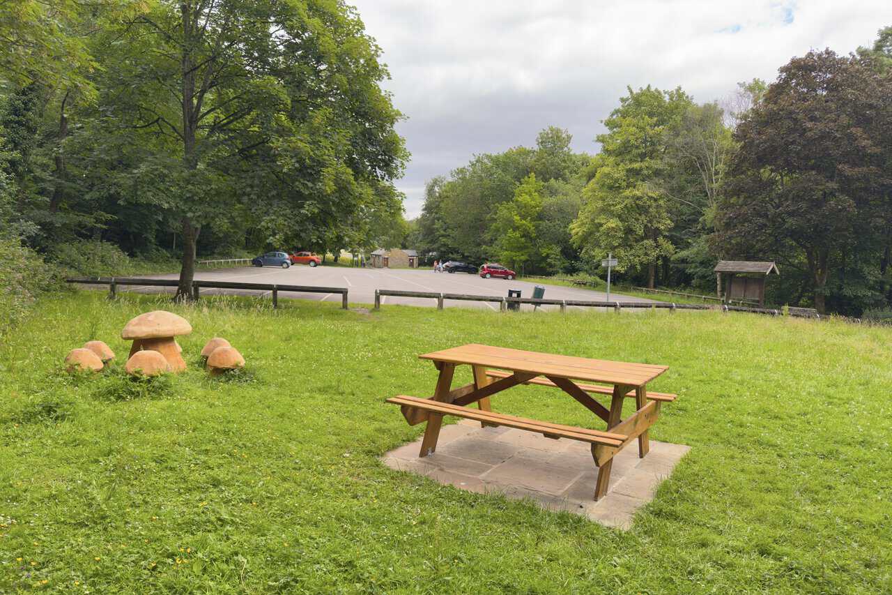
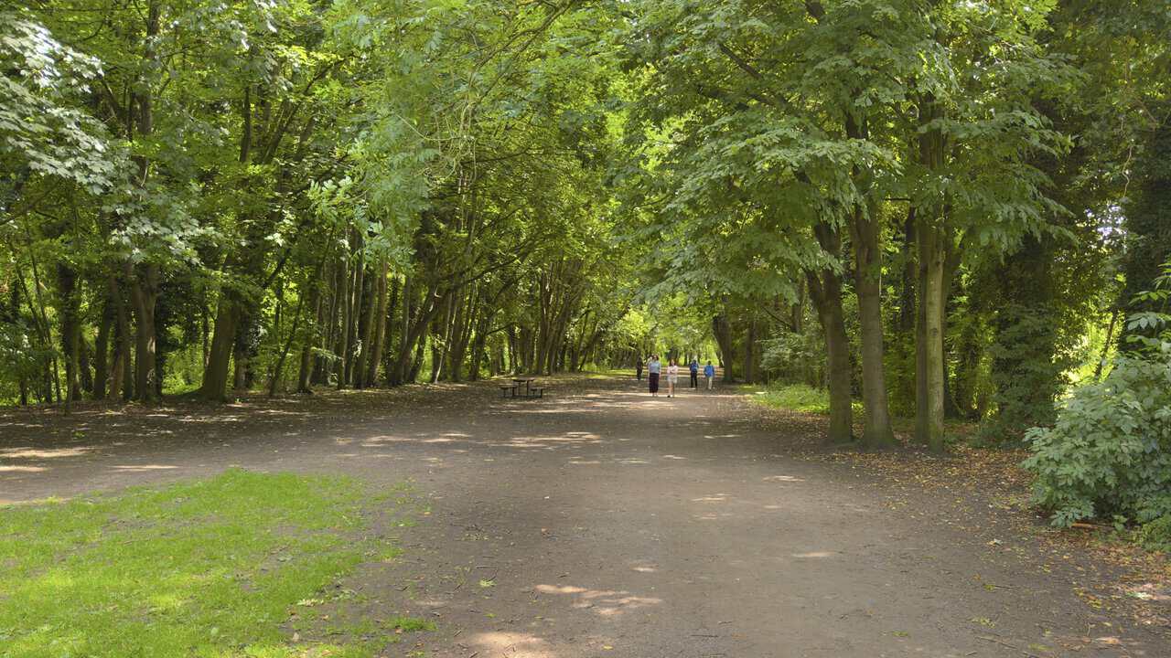
After crossing the main road and taking the footpath opposite, I keep left through the trees and arrive at the picnic area beside Round Howe Car Park. It is a welcoming spot, with wooden picnic tables set out on the grass and a cheerful group of carved wooden toadstools that children always seem to enjoy. Round Howe sits at the heart of a network of woodland and riverside trails, threading through some nationally important broadleaved woodland on the steep, north-facing valley side. Much of this ancient woodland is over four hundred years old and dominated by ash, with sycamore, beech, oak and lime among the mix, while the limestone grasslands along the riverside come alive with colour in the early part of the year. It makes a natural place to pause before I cross the river and continue on my way.
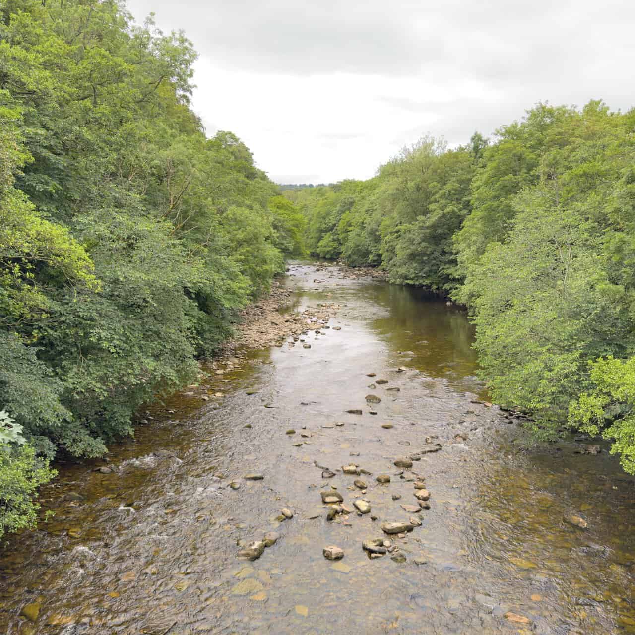
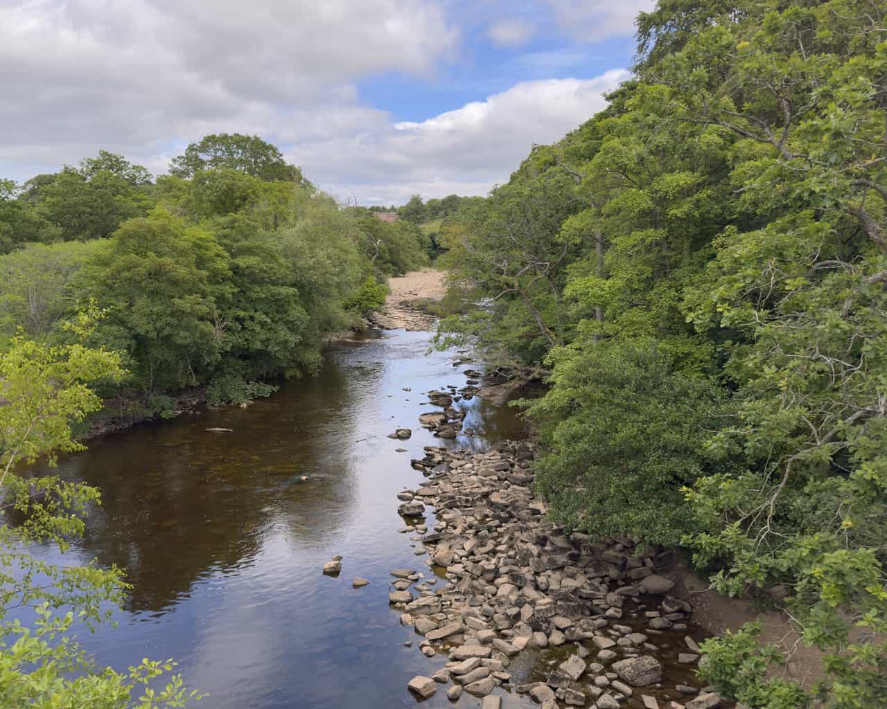
To reach Hudswell Woods, I cross the River Swale on a footbridge, and stop for a moment to look upstream. The Swale runs clear and shallow here over a wide, stony bed, curving away between steep, thickly wooded banks. It is a peaceful view, and a fitting place to pause. The Swale is often described as the fastest flowing river in England, its name coming from an old word meaning rapid, or liable to flood. It rises high in the Pennines and gives its name to Swaledale, running for around seventy miles down through the dale, past Richmond and on towards the River Ure, which it eventually joins to become the River Ouse.
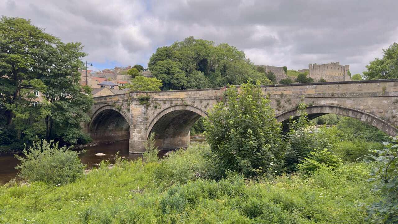
After a delightful stretch of walking through woodland and meadow, roughly following the Swale eastwards, I reach Green Bridge. It is a handsome, honey-coloured stone bridge of three arches, designed by the celebrated architect John Carr and built in 1789 to replace an older crossing that had been damaged by flooding. For centuries this was the only bridge over the Swale at Richmond, and it carried the old turnpike road towards Lancaster. It takes its name from Richmond Green, which it once connected to the far bank, and it is now a Grade II listed structure. Beyond the bridge, the ruins of Richmond Castle rise dramatically on their cliff above the river, giving one of the finest views of the whole walk.
ADVERTISEMENT
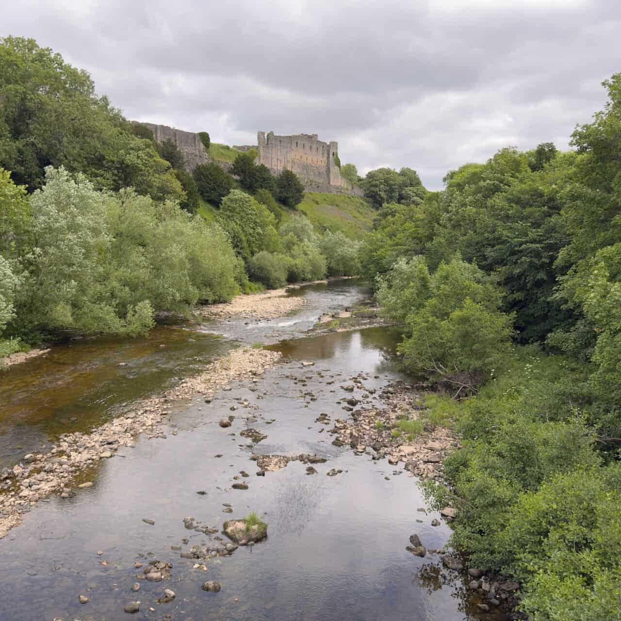
From Green Bridge I look downstream, with the River Swale running shallow over its stony bed and Richmond Castle standing high on the cliff to the left. It is a magnificent sight. The castle was begun by Alan Rufus, a Breton kinsman of William the Conqueror, from around 1071, in the years after the Norman Conquest, and it was built to secure Norman control over the north of England. Its great keep, with walls some eleven feet thick, was added a century later. Richmond Castle is one of the best-preserved early Norman castles in England, and it is now cared for by English Heritage. Seen from the riverside like this, with the walls rising above the trees, it is easy to understand why the Normans named the place Riche Mount, meaning the strong hill.
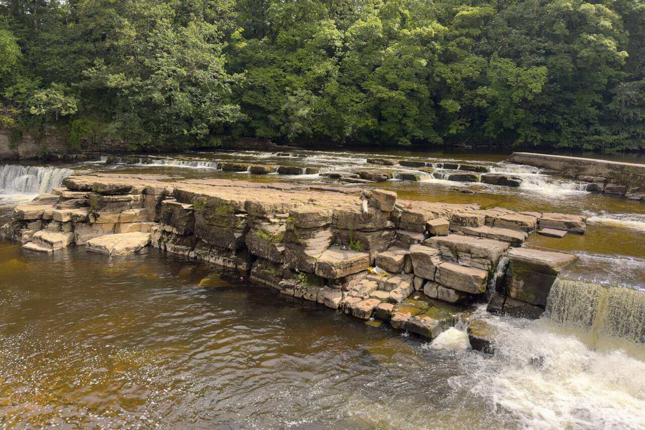
Following Riverside Road beneath the castle walls, I reach Richmond Falls, where the Swale tumbles down a series of broad limestone ledges close to the heart of the town. These are among the last waterfalls on the river before it leaves the dale for the lower country of the Vale of Mowbray, and their size can change dramatically with the weather, from a gentle flow to a powerful rush after heavy rain. The falls sit at a spot long known as the Foss or Force, from an old Norse word for a waterfall, and this stretch of the river was once home to a corn mill and, later, a paper mill. With the great flat rocks in the middle of the water and the wooded banks all around, it is a fine place to pause.
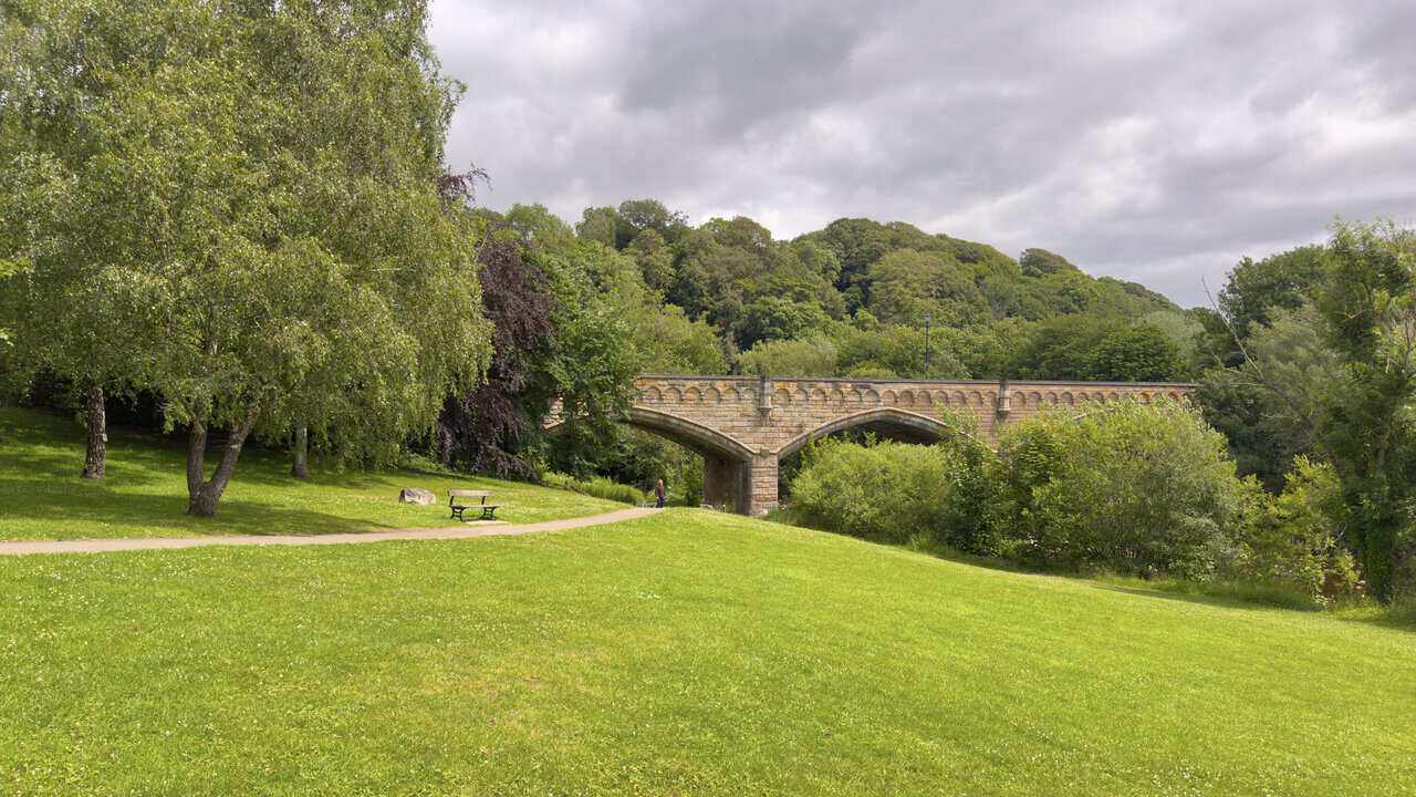
From the falls I follow the tarmac path across the open parkland known as The Batts. This broad stretch of grass beside the river takes its name from a word of Scandinavian origin meaning an area that floods, and although it is now a peaceful place for a stroll, it was once a hub of industrial activity. The power of the Swale was harnessed here from medieval times by a succession of watermills, used over the years to grind corn, saw wood, make paper and prepare cloth. The millstones and pit-wheel that can still be seen on The Batts are remnants of the Georgian Church Mill, which stood here until it was demolished in 1969. Ahead of me, spanning the river, is Mercury Bridge. This fine stone bridge was built in 1846 to connect the town to its new railway station, and in its early days the pinnacles on top of the parapets carried gaslights. It was given the name Mercury Bridge in 1975, though many local people still know it by its older name of Station Bridge.
ADVERTISEMENT
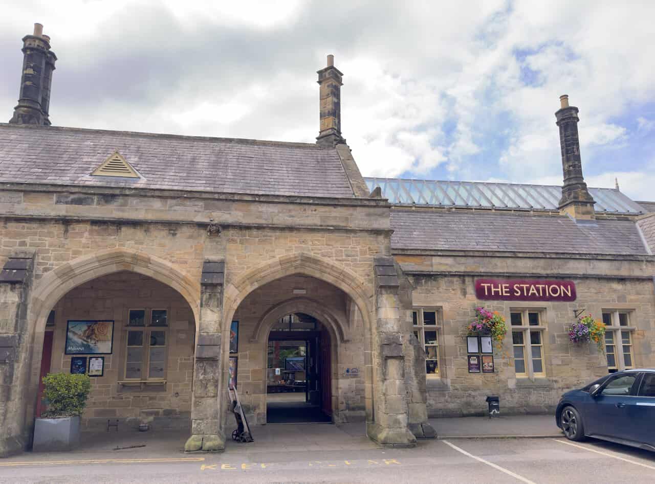
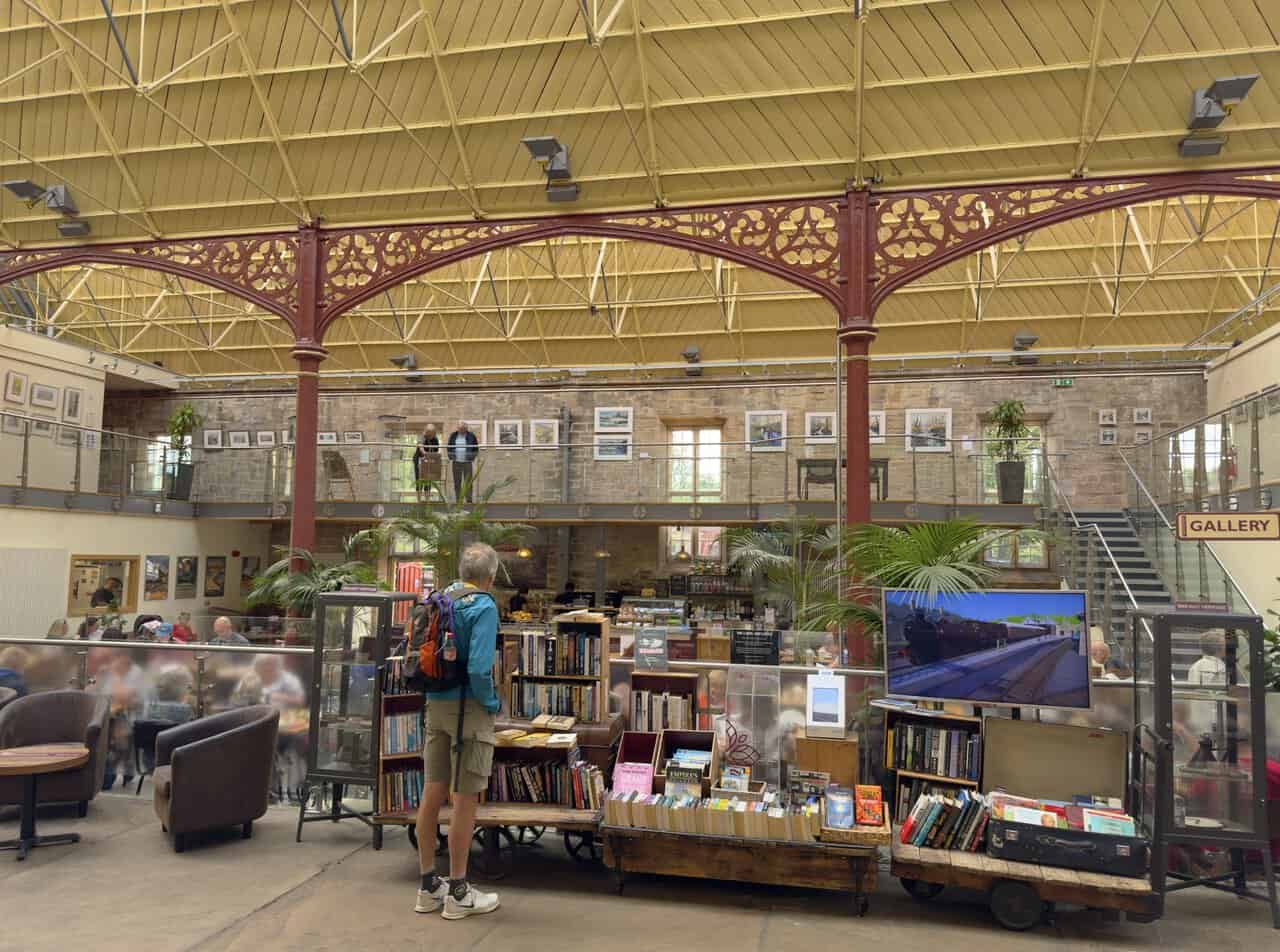
Crossing Mercury Bridge, I turn and make my way into The Station, walking in front of the old station buildings. This handsome stone building was designed by the York architect George Townsend Andrews and opened in 1846, built deliberately to blend in with the character of the market town it served. For over a century it welcomed trains into Richmond, at the end of a branch line from the main route near Darlington, until the line closed in 1969. The building later fell into disuse, but it was rescued and given a new lease of life through a major community restoration.
Stepping inside The Station, I find that it has been beautifully transformed. It reopened simply as The Station in 2007, and it is now a lively hub with a three-screen cinema, a café bar, an art gallery, a bookstall and a range of independent shops and food producers. It has kept many of its original railway features, and looking up I can admire the magnificent glazed roof and the ornate ironwork of the old train shed. It is owned and run by the Richmondshire Building Preservation Trust, a local heritage charity, with the profits going back into the upkeep of the building. Today it makes a welcoming place to pause and perhaps enjoy a coffee before pressing on.
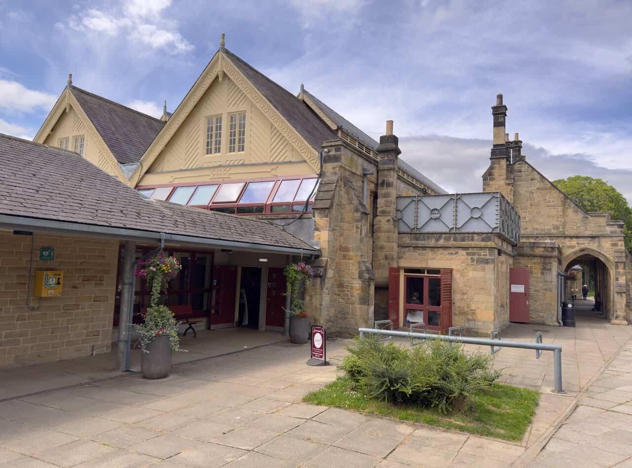
Leaving The Station behind me, I take a moment to look back at the building from the far side. From here you can see how cleverly the old station has been adapted for its new life, with its steep gables, patterned bargeboards and tall chimneys still very much as the Victorians built them, alongside more recent additions that let in the light. With its history and its setting beside the Swale, The Station is a fitting landmark to pass before I head on towards Easby.
On the far side of a cobbled road, I pick up a wide, well-made gravel path and follow it into the trees. This is the start of the Easby Loop, a popular short walk that runs from The Station out to Easby Abbey and back along the river. The path here follows the course of the old railway line that once carried trains between Darlington and Richmond, and it makes for easy, level going beneath an archway of trees. Quite a few people are out enjoying the route, and picnic tables sit just off the path, inviting walkers to stop for a while.
ADVERTISEMENT
After about a mile beneath the trees, the old railway line brings me to a footbridge across the River Swale. This is the point where the Easby Loop begins to swing round towards the abbey. I pause on the bridge to look upstream, where the river runs slow and shallow between wooded banks, with broad shingle beds and scattered rocks along its edge. It is a quiet, restful spot, and the river here feels a world away from the rush of the falls back in town.
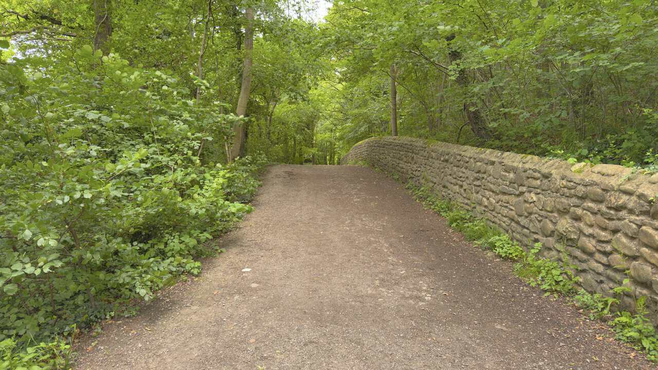
Across the footbridge, I turn and follow the wide gravel path onward towards the Easby Loop café. The way runs gently through the woodland, with a low drystone wall on my right and the trees closing in overhead. The Swale is now hidden away below on my left, and the walking is easy as the path leads me on towards Easby Abbey.
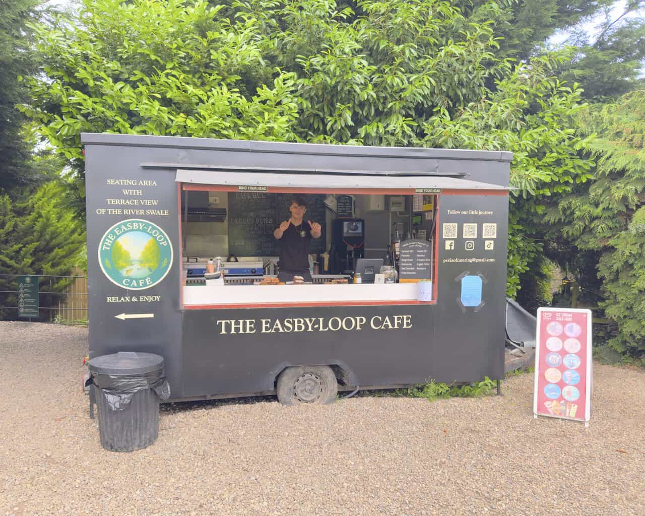
A little further along, I pass the Easby Loop café. Housed in a smart painted catering trailer, it serves hot food, hot and cold drinks and homemade cakes, with a menu that runs from breakfasts and baps to burgers and loaded fries. There is a good choice of teas and coffees, and you can add a luxury flavour to your drink, while Wall’s ice cream is sold here too. As the café’s own signage puts it, there is a seating area with a terrace view of the River Swale, with the simple invitation to relax and enjoy. You can follow the café on Facebook, Instagram and TikTok, where they invite you to follow their little journey, or get in touch by email at perksofcatering@gmail.com. Their Facebook page is at https://www.facebook.com/p/The-Easby-Loop-Café-61577508816885.
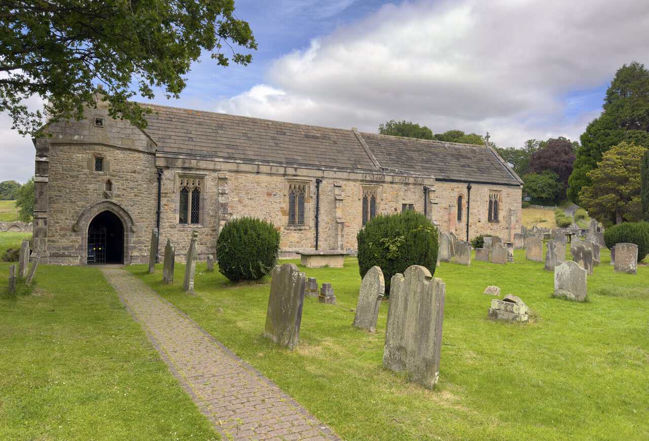
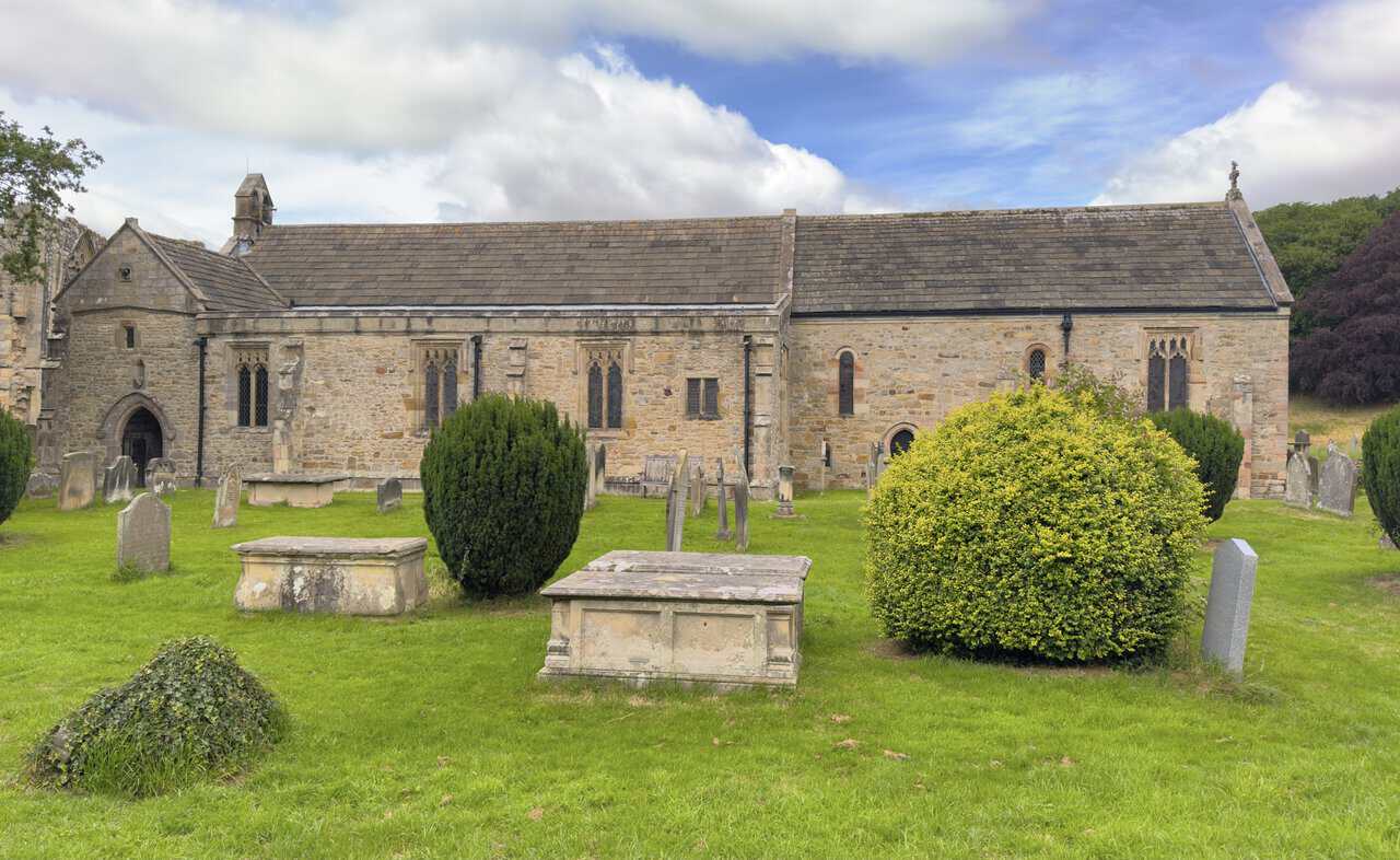
Following the path round, I come to St Agatha’s Church, the parish church of Easby, which stands right beside the abbey. It is a low stone building with a long nave and chancel under a stone-slate roof, and a cobbled path leads up through the churchyard to the arched south doorway. Though it sits quietly in the shadow of the abbey ruins, the church is in fact older than the abbey itself, with parts of it dating back to around the 1150s, and it remains an active place of worship to this day.
ADVERTISEMENT
From this side I can take in the full length of the church, with its weathered gravestones and stone table tombs scattered across the green churchyard. The building is Grade I listed, and it holds some real treasures inside, most famously a set of beautifully preserved wall paintings dating from around 1250. These were covered over during the Reformation and only rediscovered and restored during the Victorian era. The church is also known for the Easby Cross, an eighth-century carved stone cross, a replica of which stands inside, with the original now held in the Victoria and Albert Museum in London.
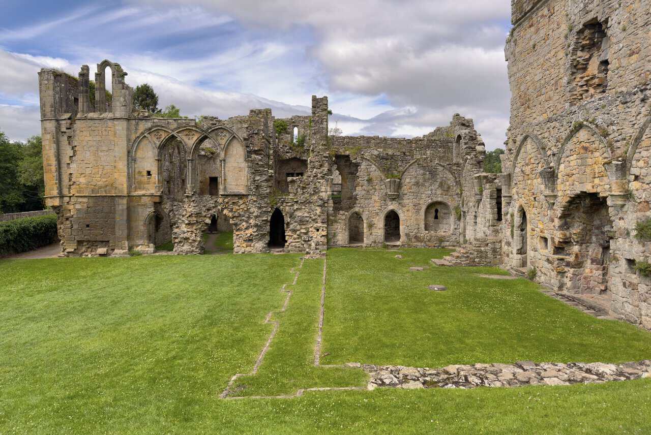
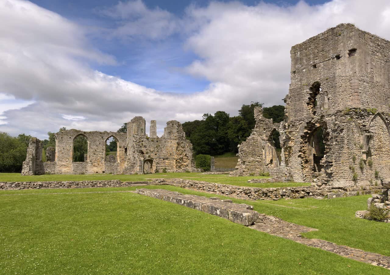
I follow the path down to Easby Abbey and stop to take in the scale of the ruins. Known in the Middle Ages as the Abbey of St Agatha, it was founded in 1151-2 by Roald, Constable of Richmond Castle. It was a house of Premonstratensian canons, the third of this order to be established in England. Unlike monks, these were ordained priests who lived together as a community, following a rule of austerity while carrying out preaching and pastoral work in the surrounding parishes. They were known as the White Canons, from the simple, undyed robes they wore.
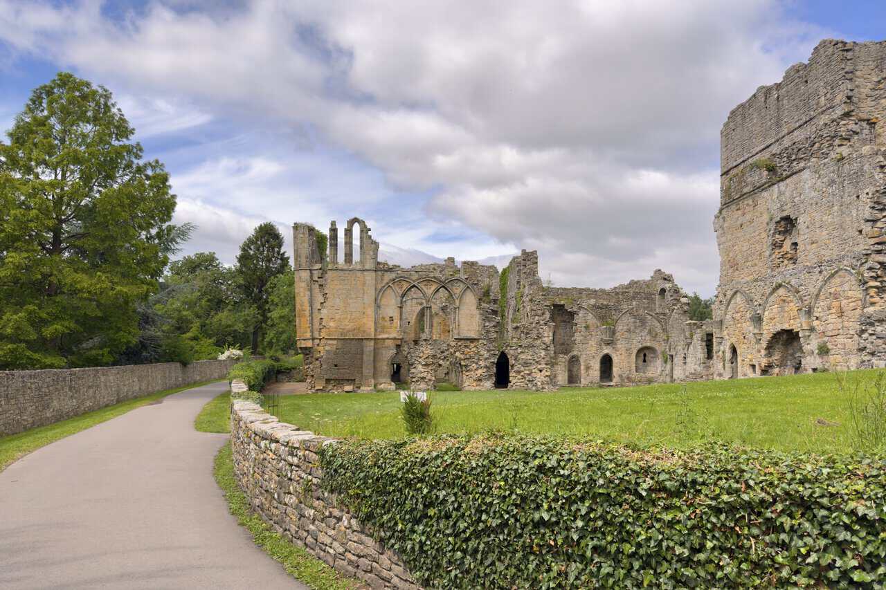
Walking in among the walls, I get a real sense of how large and well-appointed the abbey once was. The canons here extended generous hospitality to travellers and to the local poor, and over time the community grew wealthy, largely through sheep farming and gifts of land. That prosperity paid for grand rebuilding, and the abbey even founded a daughter house at Egglestone, further up the dale. The Scrope family, a powerful local dynasty, later became important patrons, and several of them were buried within the abbey’s walls.
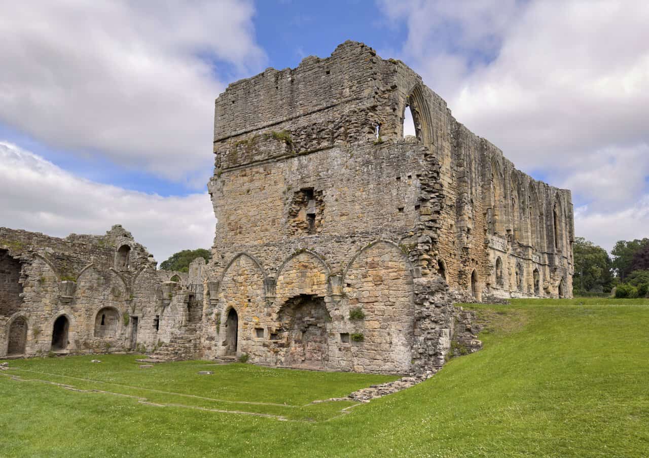
Like most monasteries in the north, Easby had its share of hard times. Standing so close to the Scottish border, it suffered from raids during the Middle Ages, and in 1346 it was badly damaged by an English army billeted here on its way to the Battle of Neville’s Cross. The greatest blow came in the late 1530s, when Henry VIII dissolved the monasteries. Easby was abandoned and left to fall into ruin, though some of its finest features survived. The abbey’s beautifully carved choir stalls were rescued and can still be seen today in Richmond’s parish church.
ADVERTISEMENT
Looking across the site, with its roofless walls and grassy foundations, it is easy to see why these ruins have drawn visitors and artists for so long. The great painter J. M. W. Turner sketched Easby, capturing its romantic setting beside the River Swale. Today the abbey is a Grade I listed site, cared for by English Heritage, and it is free to walk among the ruins and imagine the life the White Canons once led here. It is a peaceful and atmospheric place, and one of the real highlights of my Richmond walk.
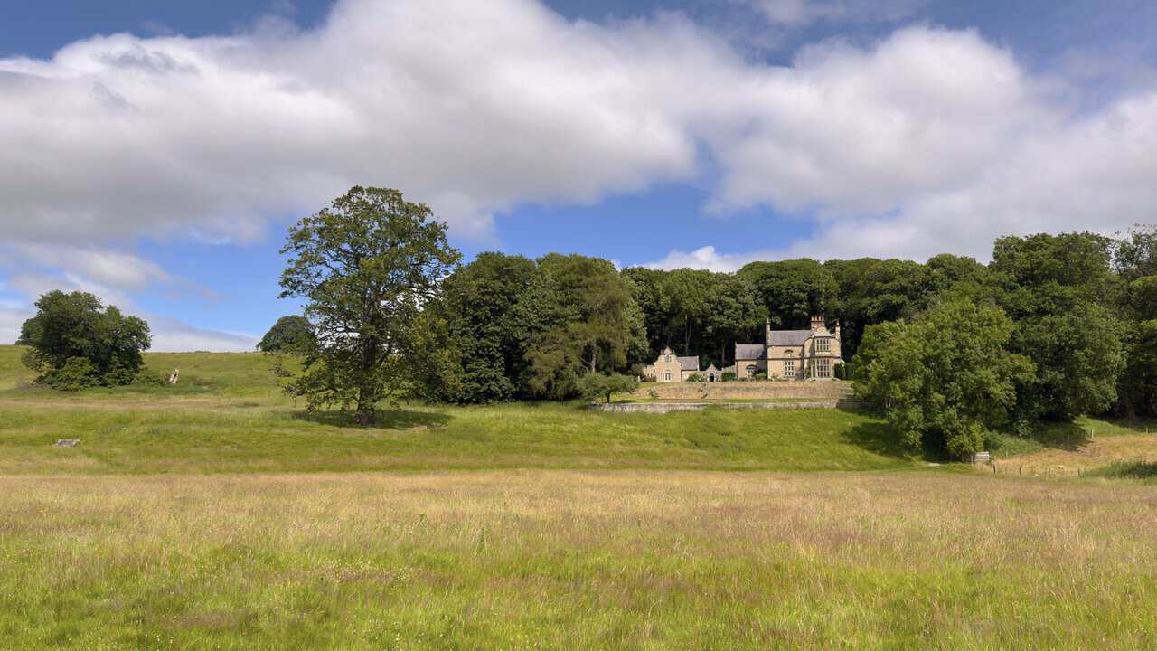
After leaving the grounds of Abbey Mill, I pick up the footpath along the edge of a large meadow. Looking across the fields to my right, I catch sight of a handsome stone property, tucked into the trees and framed by woodland behind it. I believe this is St Agatha’s House, though I may be wrong about the name. Whatever it is called, it makes a lovely sight from the path, its pale stone and gabled roofline standing out against the greenery, with the rough grassland of the meadow stretching away in front of it.
Following the woodland path, I pass the Drummer Boy’s Stone, a simple stone set on a low plinth beside the path and marked with a small plaque. It ties in with one of Richmond’s best-known legends. The story tells of a secret tunnel said to run from Richmond Castle towards Easby Abbey. A young drummer boy was sent to explore it, drumming as he went so that soldiers could follow the sound above ground. They tracked his progress as far as this spot, where the drumming suddenly stopped. He was never seen again, and the stone is said to mark the place where the sound was last heard.
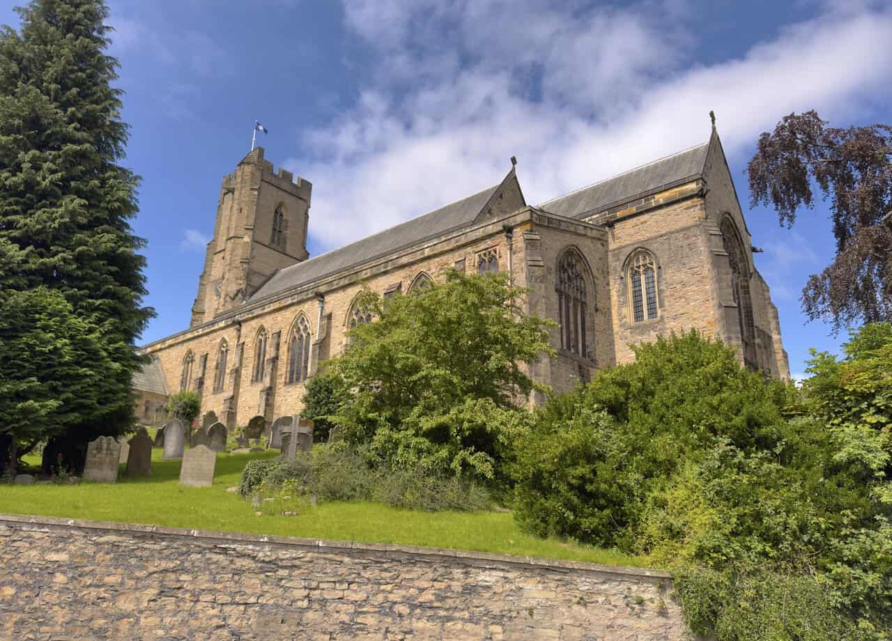
Back in Richmond, I walk up Station Road and continue uphill, passing the church of St Mary the Virgin on my right. This is the town’s parish church, and it has a long history, with parts of it dating back to the twelfth century, though it was much enlarged over the years and heavily restored in the 1850s by the celebrated Victorian architect Sir George Gilbert Scott. Its tall tower was begun in 1399. Inside, the church holds a lovely link to the earlier part of my walk, in the form of carved choir stalls that were brought here from Easby Abbey after the monasteries were dissolved. It is also home to the regimental chapel of the Green Howards, the local Yorkshire regiment, and its churchyard holds a plague stone marking the burial place of those who died in the town during an outbreak in the late 1590s.
ADVERTISEMENT
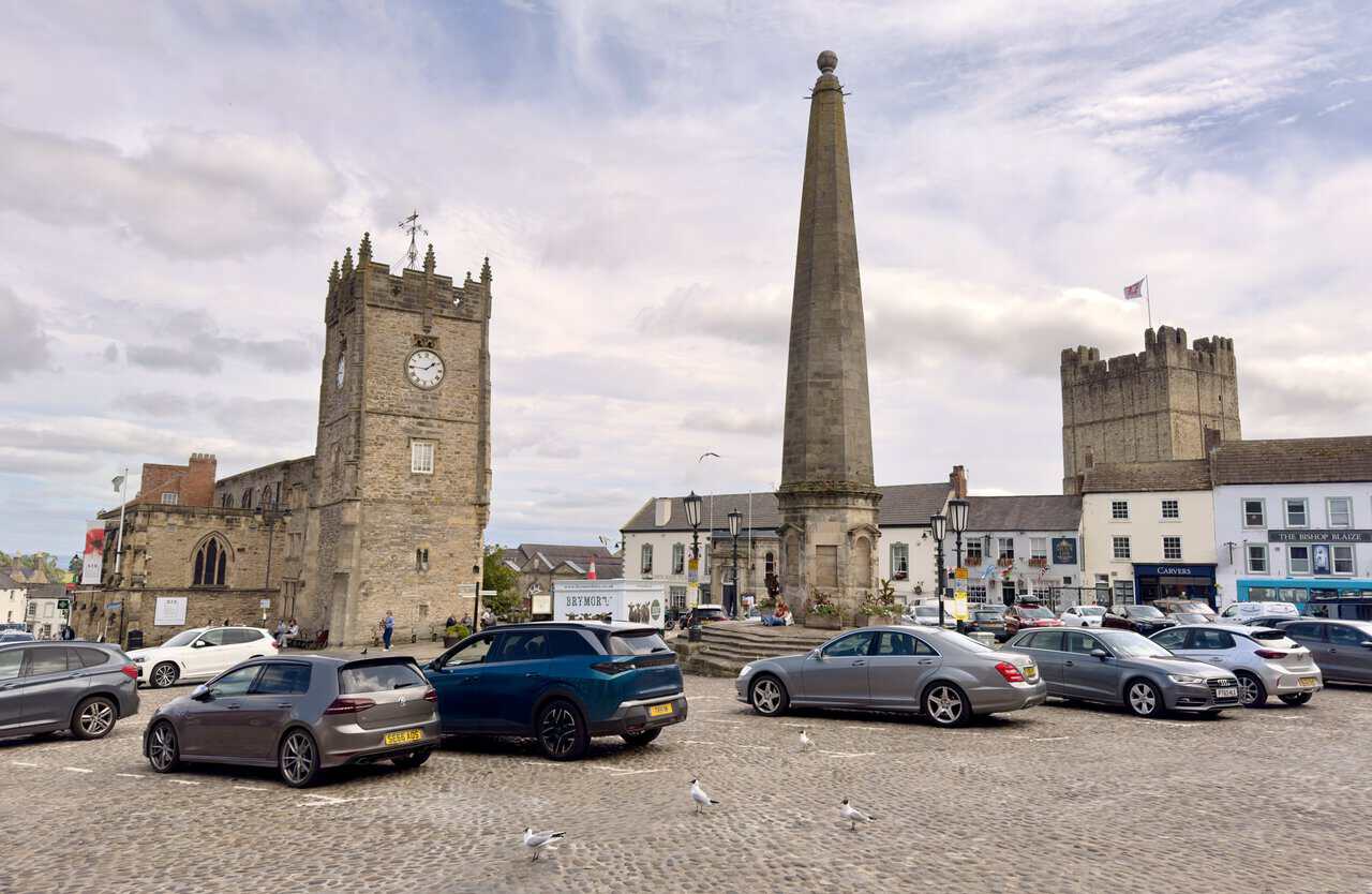
A little further up, I reach the Market Place, the cobbled heart of Richmond and one of the largest market squares in England. At its centre stands the obelisk, built in 1771, which marks the site of the town’s old water supply. Around the square rise some of the town’s most familiar landmarks. The clock tower belongs to Holy Trinity Church, an unusual building that once served as a chapel to St Mary’s and now houses the Green Howards Regimental Museum, while away to the right the great keep of the castle looks down over the rooftops. Lined with shops, pubs and cafés, the Market Place is a lively and handsome place to arrive as the walk nears its end.
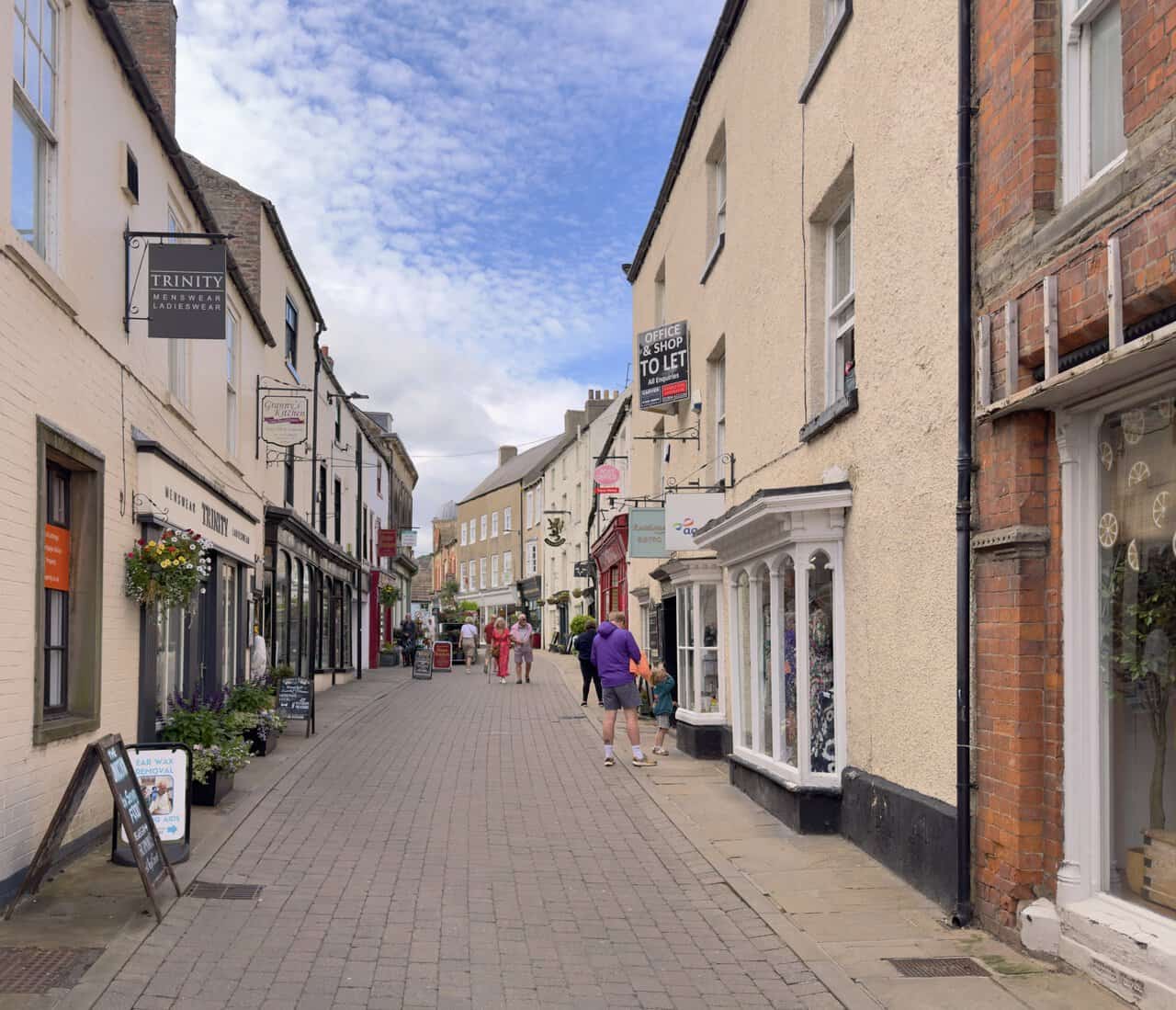
Turning off the Market Place, I make my way along Finkle Street, one of Richmond’s narrow old thoroughfares. It is a charming, pedestrian-friendly lane lined with independent shops, cafés and eateries, their hanging signs and flower baskets giving it a friendly feel. This is one of the oldest streets in the town, and it makes a pleasant place for a gentle stroll near the end of my Richmond walk. From here, I turn onto Rosemary Lane and head down towards the main road, where a left turn leads me back to Nuns Close Car Park and the end of a thoroughly enjoyable day out.
ADVERTISEMENT