ADVERTISEMENT
Explore Yorkshire Dales Lead-Mining History with the Bolton Castle Walk
You begin your Bolton Castle walk by parking in the pay-and-display Bolton Castle car park. From here, turn left and head east along the road between Bolton Castle and Saint Oswald‘s Church, which takes you back into the village of Castle Bolton.
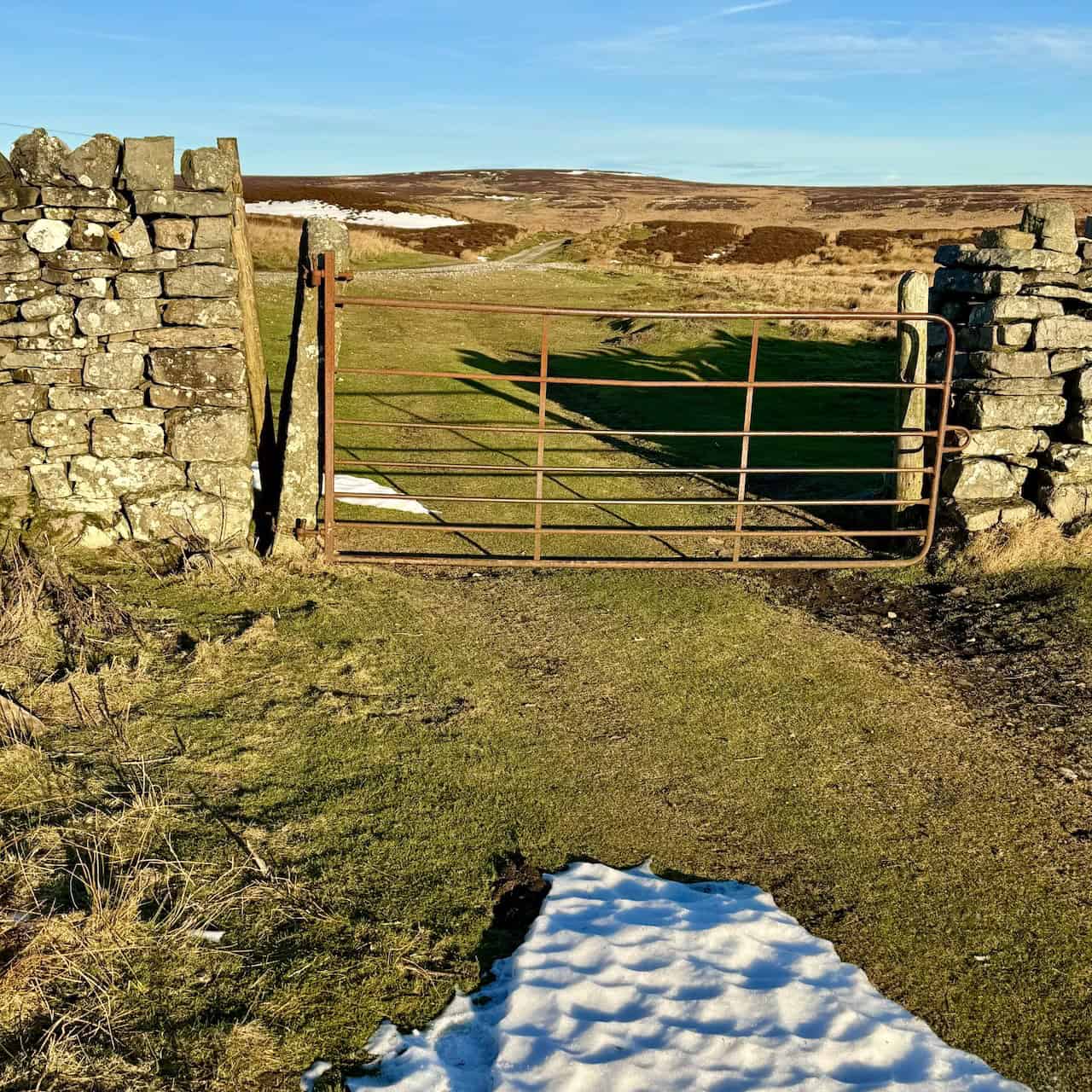
Look for the public bridleway sign pointing towards Grinton, 5 miles away, on your left between two houses. Follow the track north as it leads between two dry-stone walls and gradually rises. Pass through a gate to enter the open countryside, and cross a small stream via the concrete footbridge. Continue north along the grassy path, keeping the dry-stone wall on your left, and head towards the small wooded area known as Bull Park Plantation.
As you continue your Bolton Castle walk, go by the right-hand side of this wood, then carry on uphill across Blackhill Park with the wall still on your left. When the wall ends, keep going straight ahead. The path becomes wider and curves to the right, then left, reaching Black Hill. Pass through the gate in the dry-stone wall to join a stone track, and continue straightforward in a northerly direction onto open moorland. You stay on this wide stone track for over half a mile (0.8 kilometres) until you descend into a shallow valley and arrive at Dent’s Houses. Go by two stone buildings on your right, then cross the bridge over Apedale Beck to reach a crossroads.

ADVERTISEMENT
Turn right to follow the track east for about three-quarters of a mile (1.2 kilometres) until you meet a tarmac road. Keep straight across the cattle grid, and continue along the road in a south-easterly direction for roughly half a mile (0.8 kilometres). As the road curves to the right, go straight ahead onto the stone track across Thorny Bank Hill. The track then sweeps around to the left, taking you east towards a chimney visible on a distant hill.
After about half a mile (0.8 kilometres), you will find the remains of Cobscar Mill, a derelict lead-mining site. Turn left here and follow a track uphill in a north-easterly direction, passing a large pond on your right. This part of your Bolton Castle walk soon brings you to a pair of stone benches, shortly followed by a neatly built cone-shaped cairn. At the cairn, turn right and head downhill along the stone track. Continue in a south-easterly direction for about 1¼ miles (2 kilometres), ignoring any footpath signs, until you reach a main road.
Cross the road and go straight onto a smaller minor road opposite, which leads you after roughly three-quarters of a mile (1.2 kilometres) into the village of Preston-under-Scar. You walk all the way through Preston-under-Scar, ignoring the left turn signposted for Redmire, Wensley, and Leyburn. At the village’s western end, turn left just after Jubilee Cottage and take the public footpath downhill to the main road. Turn right briefly, then take another left onto a public footpath.

ADVERTISEMENT
Cross the Wensleydale Railway, move through several fields heading diagonally south-west, and pass a large stone barn on your right. The path may be faint, so aim for the right-hand side of the farm at Wood End. As you near the farm, veer right to reach Wood End Lane. Turn right onto the concrete lane, walk past St Mary’s Church on your left, and continue along the tarmac road to the southern edge of Redmire. Take another right turn to follow the main road into the village centre. When you reach the village green, pick up the road to the left and pass the Redmire Village Pub, formerly the Bolton Arms.
Your Bolton Castle walk then takes you north along the main road, where you turn left at the sign for a public footpath running between houses. Go directly across the fields, and use the footbridge to cross Apedale Beck. Continue on the public footpath for a little over half a mile (0.8 kilometres) across fields and farmland, generally in a north-westerly direction, aiming towards Castle Bolton. If the weather is clear, you will see Bolton Castle, which makes navigation easier. The footpath leads to the eastern side of the village, where you simply turn left to return to the car park.
Your Bolton Castle walk covers just under 10 miles (16 kilometres) in the Wensleydale area of the Yorkshire Dales, taking in historic buildings, open and exposed moorland, intriguing lead-mining sites, picturesque villages, and a beautiful landscape.
Bolton Castle Walk: Maps and Tools
Visit either the OS Maps website or the Outdooractive website to view this walking route in greater detail. Both platforms offer a range of features, including the ability to print the route, download it to your device, and export the route as a GPX file. You can also watch a 3D fly-over and share the route on social media. Additionally, this page includes a printable version of the walk in PDF format.Plus there is a supporting video, available for you to watch on YouTube.
Bolton Castle Walk: Distance, Duration, Statistics
Distance: 9½ miles
Distance: 15 kilometres
Duration: 4½ hours
Ascent: 1151 feet
Ascent: 351 metres
Type: Circular walk

ADVERTISEMENT
Recommended Ordnance Survey Map
The best map to use on this walk is the Ordnance Survey map of the Yorkshire Dales Northern & Central Area, reference OS Explorer OL30, scale 1:25,000. It clearly displays footpaths, rights of way, open access land and vegetation on the ground, making it ideal for walking, running and hiking. The map can be purchased from Amazon in either a standard, paper version or a weatherproof, laminated version, as shown below.
Standard Version
Yorkshire Dales Walking Guidebooks
Walking in the Yorkshire Dales: North and East, by Dennis Kelsall, describes 43 circular day walks of 3 to 12 miles across the Howgills, Mallerstang, Swaledale, Wensleydale, Coverdale and Nidderdale, with Ordnance Survey mapping and notes on parking and refreshments.
15 Short Walks in the Yorkshire Dales, by Jonathan and Lesley Williams, covers the area around Sedbergh, Kirkby Lonsdale and Ingleton. Its 15 routes of 1 to 7 miles each take under three hours, ideal for families or a relaxed half day out. Both books can be purchased from Amazon, as shown below.
Walking the Yorkshire Dales
Bolton Castle Walk: About Castle Bolton Village
Castle Bolton is a small village in Wensleydale, North Yorkshire, located within the Yorkshire Dales National Park. It is important to note that Castle Bolton refers specifically to the village, while Bolton Castle, a significant historical landmark, is situated on the western edge of the village. The two share a close historical connection but remain distinct.
The Village of Castle Bolton
The village is a linear settlement, with cottages and houses arranged along a central village green. As of the 2011 census, the population of the civil parish was recorded as less than 100; in 2015, North Yorkshire County Council estimated the population to be 60. The name ‘Bolton’ originates from Anglo-Saxon words meaning ‘an enclosure or settlement’. The village likely evolved during the Anglo-Saxon period, although its development is closely tied to the construction of Bolton Castle in the late 14th century. The majority of the cottages in the village date from the 18th and 19th centuries.
Surrounding Villages
Castle Bolton is situated near several other villages that contribute to the character of Wensleydale:
Redmire: Approximately 1 mile (1.6 kilometres) south-east of Castle Bolton, Redmire is a village and civil parish with a population of 384 as of the 2011 census.
Carperby: Located about 2 miles (3.2 kilometres) south-west of Castle Bolton, Carperby is a village known for its traditional stone-built houses and proximity to Aysgarth Falls.
Aysgarth: Approximately 3 miles (4.8 kilometres) south-west of Castle Bolton, Aysgarth is famed for its picturesque waterfalls and scenic walks.
Related Walk: Similar to the Bolton Castle Walk
Discover waterfalls and charming villages on the Aysgarth walk in Wensleydale
Key Features of Castle Bolton
Castle Bolton has several notable features that reflect its historical and cultural significance. The village is home to four listed buildings:
St. Oswald’s Church: Built around 1325, this church predates the castle and stands as a reminder of the village’s medieval roots.
Bolton Castle: A 14th-century fortress that dominates the village.
Rose Cottage: A 17th-century stone cottage.
K6 Telephone Box: Designed by Sir Giles Gilbert Scott, this iconic red telephone box is a listed structure.
The village is also surrounded by a well-preserved medieval field system dating back to the 12th century, when the land was part of a grange owned by Rievaulx Abbey. This historical feature is a rare example of early agricultural practices.
Bolton Castle
Bolton Castle was built between 1378 and 1399 by Sir Richard le Scrope. It served as a fortress and a family residence and remains one of the best-preserved medieval castles in England. The castle gained national significance in 1568 when Mary, Queen of Scots, was imprisoned there for six months following her flight from Scotland.
Today, Bolton Castle is a popular visitor attraction. It features a great hall, chapel, and restored gardens, which include a maze, herb garden, and vineyard. Seasonal events such as falconry displays and archery demonstrations take place at the castle, providing visitors with insights into medieval life.
Bolton Castle Walk
The area around Castle Bolton offers excellent walking opportunities. The Bolton Castle walk on this website page is one of many routes that takes visitors through the scenic countryside of Wensleydale. This walk offers views of Penhill, the surrounding dales and moorlands, and the historical village itself.
Bolton Castle Walk: My Photos
After parking in the Bolton Castle car park, we begin our Bolton Castle walk. We head back into the village of Castle Bolton and follow a bridleway on our left, which leads north between attractive stone-built houses. These houses face south and are bathed in winter sunlight.

ADVERTISEMENT
The bridleway carries us north onto open moorland. We cross a small stone-built footbridge and continue along a gently rising grassy track that points towards a small wood on our left, shown in this photograph. The wood is called Bull Park Plantation.

We follow the bridleway north beside a dry-stone wall in an area called Anderson Park. The snow from earlier in the month has almost melted, though we imagine how deep it must have been where it drifted against the walls. The path remains straightforward, but the thawing snow makes the ground slightly wet and squelchy underfoot—nothing that prevents us from enjoying our Bolton Castle walk.

ADVERTISEMENT
The bridleway continues uphill across Blackhill Park. Eventually, we reach Black Hill, where we pass through a gate in a dry-stone wall and join a stone track extending further north over the moorland. The weather is superb, and we are already thoroughly enjoying our Bolton Castle walk.
Continuing north on the stone track over the open, exposed moorland feels exhilarating. The track levels out and is easy to follow. It is a clear, bright day, which enhances our experience.

ADVERTISEMENT
Before long, the track begins to descend gently, and we soon expect to see Dent’s Houses in a shallow valley ahead. This valley was formed by Apedale Beck.

We descend into the valley at Dent’s Houses, spotting a crossroads just after the bridge over Apedale Beck. To the left, or west, lies Apedale Road, leading towards Crackpot and Gunnerside. Straight ahead, another track crosses the moorland towards Grinton and Reeth in Swaledale. We turn right, heading east towards Redmire Moor and, eventually, Preston-under-Scar.

ADVERTISEMENT
Dent’s Houses
Dent’s Houses consists of two stone-built shooting lodges on the south side of Apedale Beck, plus a smaller stone building and a barn on the north side. There is also a sheepfold here.

We look inside one of Dent’s Houses’ buildings, which proves ideal for a break. We have sheltered here in various weather conditions before. Dent’s Houses and the surrounding land belong to the Bolton Estate, and a sign inside welcomes walkers to use the building when it is not required by the estate.

ADVERTISEMENT
We notice a guest book in this building at Dent’s Houses. Walkers often jot down their appreciation for this refuge, which sits in a rather exposed corner of the countryside.

After a short rest in one of the larger stone buildings at Dent’s Houses, we cross a single-arched stone bridge over Apedale Beck.
Standing on the bridge, we look west, upstream of Apedale Beck, across East Bolton Moor. It offers a serene view, and we pause to savour this moment on our Bolton Castle walk.

ADVERTISEMENT
To the north of Apedale Beck stands the smallest of the three Dent’s Houses buildings, adjacent to a corrugated iron barn. Benches lean against its exterior, and although there is some old furniture inside, it is not as comfortable as the other two buildings.

Cobscar Rake and Cobscar Mill
Departing Dent’s Houses, we continue our Bolton Castle walk generally south-east for a couple of miles (3 kilometres) to Redmire Moor. We cross Thorny Bank Hill and arrive at an area with disused quarries, tips, and shafts. Passing Cobscar Rake, we reach Cobscar Mill. Both Cobscar Rake and Cobscar Mill were prominent in the Yorkshire Dales’ 18th- and 19th-century lead mining industry.

Cobscar Rake was an east-west running mineral vein that joined the Chaytor Rake just east of Cobscar Smelt Mill. It supplied lead ore processed at the adjacent Cobscar Mill.
Cobscar Smelt Mill was a lead smelting facility built in the mid-18th century to support several mines along Cobscar Rake. James Plews leased Cobscar Rake and constructed the mill shortly before 1762. It continued operating until 1878, refining lead ore from surrounding mines.

ADVERTISEMENT
The mill complex contained:
- A smelting house where the lead ore was treated.
- A peat house with four arches for storing fuel.
- Two chimneys on the roof, recorded in historical maps.
- An ore hearth for smelting lead.
- A flue system to manage fumes.
By 1823, hauling ore to Cobscar Mill was becoming difficult, sparking discussions about building a new mill. Nonetheless, Cobscar Mill remained active for several more decades.
Today, its remains are deemed historically significant. The ore-hearth lead smelt mill, flue, and chimney are listed on the National Heritage List for England, emphasising their value to the region’s industrial heritage.

Beyond Cobscar Mill, we follow a track north-east towards Cranehow Bottom on Preston Moor, where we discover two stone benches and a neatly built cairn. We seize this opportunity to take our lunch break.

Beside the benches rests a cube-shaped piece of rock bearing a plaque that reads:
IN LOVING MEMORY
DAVID ALWYNE JAMES HARTLEY
1962–2020
A GREAT MAN AND A TRUE GENTLEMAN
HE LOVED WENSLEYDALE AND THESE MOORS

ADVERTISEMENT
A few metres from the benches, we find a cone-shaped cairn standing at a crossroads near Cranehow Bottom. Built with larger, thicker stones at the base and smaller, thinner stones at the top, it glows in the winter sunlight and adds a striking element to our Bolton Castle walk.

An oval-shaped metal plaque on the cairn commemorates Henry Edward Cubitt. It reads:
REMEMBER HARRY, HENRY EDWARD CUBITT
4TH BARON ASHCOMBE
1924–2013
WHO LOVED YORKSHIRE AND THESE MOORLANDS

After our break at Cranehow Bottom, we head south-east over Chaytor Rake. Just before leaving the moor, we pass a wooden shooting lodge on our right, cross a main road, and follow a smaller minor road leading into Preston-under-Scar.

ADVERTISEMENT
In a field beside the road, shortly before arriving in the village, we see sheep covered in brightly coloured dye, happily feasting on hay that appears freshly laid by the farmer.

Preston-under-Scar
Our Bolton Castle walk carries us through Preston-under-Scar from east to west. It is a pleasant village, and we imagine it must be a fine place to reside, with countryside views and quaint cottages. Its population rose modestly from 120 in 2001 to 170 in 2011. Historically, it was part of the Wapentake of Hang West and the parish of Wensley.

The village’s name combines Old English and Old Norse, originally ‘prēost tūn sker’, meaning ‘priest’s farm (or settlement) under rock (or cliff)’. It appears in the Domesday Book as belonging to Thorfin of Ravensworth, with Count Alan of Bedale as the tenant-in-chief. It also features a mission room (St Margaret’s Church), built in 1862 and now Grade II listed.

Having walked the entire length of the village to its western side, we turn left and descend a grassy bank on a public footpath, enjoying views across Wensleydale. The path takes us down to the main road, where we walk briefly before following another public footpath towards the Wensleydale Railway.
ADVERTISEMENT
The path from the main road to the railway runs along a channel or dip in the land.

After crossing the railway line, we pass a large stone barn and traverse several fields diagonally, aiming for a farm at Wood End to join Wood End Lane. This section can be tricky because the path is not always evident, but heading in the farm’s general direction proves helpful. In the distance, Addlebrough and Wether Fell stand clear on this fine day, overlooking Bainbridge and Hawes respectively.

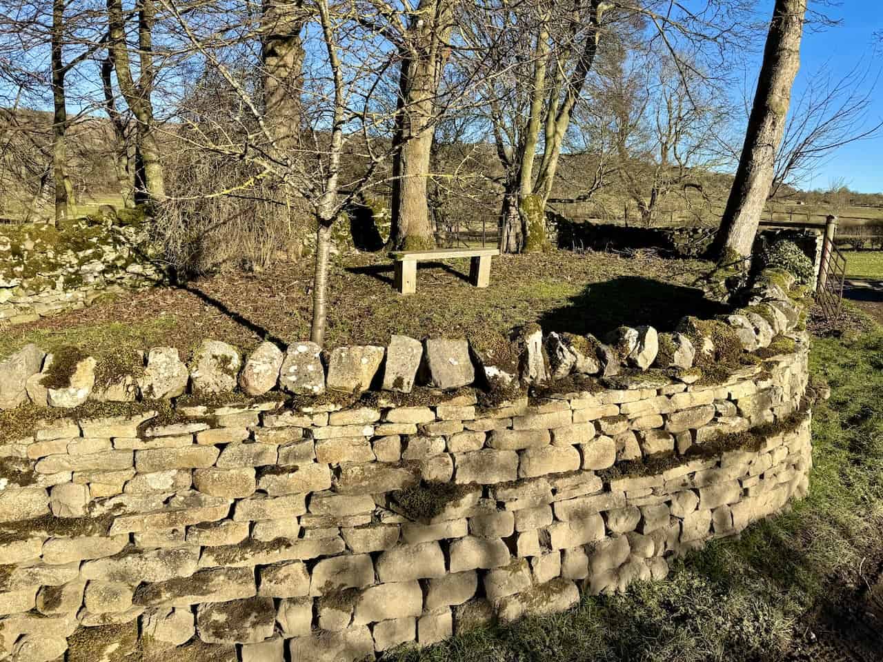
Eventually, we join Wood End Lane. Along the route, we see a small raised garden with a convenient bench directly opposite St Mary’s Church, just outside Redmire.
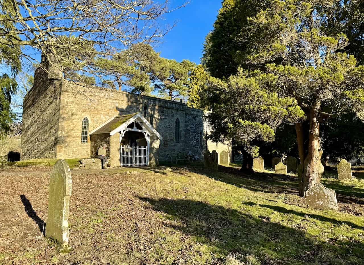
St Mary’s Church
We briefly visit St Mary’s Church before following the road into Redmire. St Mary’s, dating from around 1150, is a medieval church comprising a nave and chancel under a bellcote. It features a Norman doorway with stone seats, a 13th-century octagonal font, and a 15th-century timber roof. The church has historic ties to Coverham Abbey, where canons served until the Dissolution.
ADVERTISEMENT
This building retains many interesting medieval features, such as a Norman scroll frieze, lancet windows, and a blocked low side window once used for confessions. Inside, we notice the Royal Arms of George I (1720) and monuments to the Other family, local inhabitants from the 17th to 20th centuries.

Outside, the churchyard displays distinctive gravestones, including one shaped like a grandfather clock—an allusion to Wensleydale’s clockmaking heritage. The church’s remote setting, away from Redmire village, has inspired theories about an earlier settlement relocating, possibly due to plague, or being originally located on Redmire Scar.

Redmire
From the church, we walk west along the road, then turn right into Redmire’s centre. This peaceful village has pleasant greens and appears in the British television series All Creatures Great and Small, specifically in the episode Puppy Love, as Darrowby bus stop. The local pub, the Bolton Arms, is also featured in Beauty of the Beast.

The village green in Redmire represents the fictional Darrowby Bus Stop, where characters would arrive and depart in All Creatures Great and Small. In the programme’s first episode, Herriot alights from a bus in Richmond’s town square, but subsequent scenes of bus arrivals at Darrowby were filmed here in Redmire.

ADVERTISEMENT
Redmire Pinfold
Exiting Redmire and heading north on the main road, we pass an unremarkable dry-stone wall with a wooden door. However, a notice on the door explains that this is a pinfold, which was in use until the late 19th century.
From medieval times onwards, local authorities regulated all aspects of farming, and any violations were punished by ‘paynes’ (fines) in manorial courts. Most villagers had grazing rights for a set number of animals on common land. Animals that strayed beyond their owners’ property or exceeded these rights were impounded by a bailiff (the ‘pinder’ or ‘pounder’) in a walled enclosure called a ‘pinfold’ or ‘pound’.
To reclaim impounded animals, owners paid the manorial court’s fine plus a fee to the pounder for feeding and watering them. If they were not claimed within around three weeks, the animals were taken to market and sold, with the proceeds going to the pounder.
During the late 18th and early 19th centuries, in the manorial courts covering Redmire and Castle Bolton, fines for letting animals ‘go at large on common lands or within the streets, lanes or highways of the manor’ averaged: for cattle, sheep, horses, pigs, goats, and geese… 2s 6d; for boars… 10s 6d; and for tups and bulls… fl 1s 0d (one guinea). In 1825, the pounder’s fees were: ‘grown beasts, horses, pigs’… Os 6d; ‘mules, stirks, foals, calves’… Os 4d; ‘sheep, lambs, geese’… Os 2d.
The pounder’s role sometimes led to disputes. In 1825, the Redmire manorial court set a fine of £1 19s 11d (a large amount at the time) for anyone trying to stop the pounder from seizing stray animals or breaking into the pinfold to release them.

From Redmire’s main road, we follow a public footpath between houses and cross a footbridge over Apedale Beck. It is a pleasant spot, and we are close to finishing our Bolton Castle walk—about three-quarters of a mile (just over 1 kilometre) remains.

The footpath continues north-west towards Castle Bolton, passing a roofless, doorless old stone barn with a convenient bench and appealing countryside views.

We follow the path through a narrow gap in a dry-stone wall and keep to the right, guided by a signpost for Castle Bolton.

ADVERTISEMENT
The castle sits on the hillside, facing south across Wensleydale and illuminated by the sun. It makes a striking sight at this stage of our Bolton Castle walk.

St Oswald’s Church
Our Bolton Castle walk ends in the village of Castle Bolton, where St Oswald’s Church stands as a Grade II listed parish church. The church dates to the 14th century and stands next to Bolton Castle.
Architectural Elements
- A 15th-century tower with diagonal west buttresses, angled east buttresses, and a south-east octagonal turret.
- Crenellated nave and chancel, plus a south porch with a parvise above.
Interior Features
- A 13th-century oak chest in the nave.
- A 15th-century octagonal font with an oak cover from 1627.
- A nave ceiling with camber beams, bosses, and carved angels.
- A triple sedilia and piscina on the south side of the chancel.
- Three 15th-century stalls with misericords along the chancel’s south wall.
Stained Glass
- A panel from around 1500 in the north chapel.
- Several 16th- and 17th-century Continental panels and medallions.
- Windows by William Warrington from the 1840s.
- A window attributed to Ballantyne from about 1928.
Other Notable Elements
- A vaulted crypt under the altar, formerly used as a treasury.
- A two-manual organ built in 1897 by Lewis and Company.
- A Sanctuary Lamp with maritime-themed design elements, including a crab-claw circlet and fishtail framework.
- The Constable Tomb, final resting place of Sir Marmaduke Constable, who died in 1530.
- The Yale memorial dated 1616 (restored in 1676) honouring Alderman Hugh Yale.

Bolton Castle
Before departing, we walk onto the broad grassy field on the castle’s western side for a photograph of this remarkable fortress. Bolton Castle is a major historical site in Wensleydale, North Yorkshire, England. It was constructed between 1378 and 1399 by Richard le Scrope, 1st Baron Scrope of Bolton, who served as Lord Chancellor to King Richard II.
Renowned for its architectural prominence, Bolton Castle is a quadrangular fortress described by Nikolaus Pevsner as the ‘climax of English military architecture’, praised for its balance of defensive strength, domestic features, and orderly design.
Construction and Features
- Building commenced in 1378 under a contract with mason John Lewyn, agreed in September of that year.
- The licence to build was granted in July 1379.
- The castle reportedly cost 18000 Marks to construct, a significant sum at the time.
- It has exceptionally tall walls, which Sir Francis Knollys called ‘the highest walls of any house he had seen’.
- It features an astronomical clock in the courtyard and an innovative smoke conveyance system from the hall hearth through tunnels.
Historical Significance
Bolton Castle has witnessed numerous historic events:
- It briefly served as a prison for Mary Queen of Scots.
- During the 1536 Pilgrimage of Grace rebellion, the 8th Baron Scrope supported the uprising and sheltered Adam Sedbar, Abbot of Jervaulx.
- King Henry VIII ordered the castle to be torched in retaliation for the Scropes’ role in the rebellion, causing damage.
- It played a part in the Wars of the Roses and the English Civil War.
Presently, Bolton Castle is both a Scheduled Ancient Monument and a Grade I listed building, preserving more than six centuries of history. It remains in the hands of the Scrope family’s descendants and welcomes visitors seeking a glimpse into medieval life and architecture.
ADVERTISEMENT