Enjoy the North York Moors With the Farndale Walk From Lowna to Low Mill
This Farndale walk begins at the car park in Lowna, situated in the heart of the North York Moors. Lowna lies approximately 3½ miles (5.6 kilometres) north of Kirkbymoorside. The most direct route is to drive from Kirkbymoorside along Gillamoor Road to the village of Gillamoor, then descend Gillamoor Bank. After the bank, ignore the left turn to Farndale and continue a bit further to find the car park on your left. Alternatively, you can reach Lowna from Hutton-le-Hole or, if approaching from the north, drive from Castleton across the picturesque Blakey Ridge, which separates the valleys of Farndale and Rosedale and offers splendid views.
From the car park, take the trail heading north into the woods. Descend to the footbridge crossing Harland Beck. Shortly after, you’ll come across a signpost directing you left to the Quaker Burial Ground. Within two to three minutes, you’ll find the burial ground on your left. Enjoy the tranquil atmosphere; there’s a solitary bench where you can sit and absorb the serene surroundings.

Continue north along the woodland path for about a quarter of a mile (0.4 kilometres) until you reach a gate. Turn right and walk downhill towards the River Dove. Near the bottom, turn left and follow the path north for roughly half a mile (0.8 kilometres) to reach Dale End Bridge. Do not cross the bridge; instead, turn left and ascend steeply. After a right turn, navigate through the woods north-west to Park Farm. Continue north across the fields and open countryside, passing Cross Farm until you reach the road.
Turn right and walk along the quiet road for just over half a mile (0.8 kilometres). At Holly Bush Farm, turn left towards Keysbeck Farm. Pass through the farm and proceed north-west along the track, past Scarth Nick. This lovely area is worth a pause for coffee or lunch. After Scarth Nick, you’ll eventually reach a bridleway. Turn right and head down to the footbridge crossing West Gill Beck, then continue to High Barn. This marks the halfway point of this Farndale walk, essentially creating a U-turn in the valley.
Route Update (March 2026)
Following notification from the landowner, please note that the path from Scarth Nick to the bridleway is no longer a public right of way. Instead, before reaching Scarth Nick, look for the public bridleway branching off to the north-east. Follow this across open countryside to Horn End. At Horn End, turn right onto another bridleway and head south-east until you reach the road, which leads down to Low Mill.

From High Barn, continue south-east past Horn End holiday accommodation until you reach the road. Turn right and walk down to the hamlet of Low Mill. Walk through Low Mill and turn left at the junction, passing the Wesleyan Chapel. Continue along the road, crossing the River Dove and ascending to Daleside Road. Turn right and continue south-east for half a mile (0.8 kilometres) until you reach Rawson Syke.
At Rawson Syke, take the track on your right, slightly downhill. Continue south along the delightful route past Underhill Farm, Ewecote Farm, and Thunder Head Hill. At a junction, be sure to take the left turn signposted Lowna to lead you south to Hagg End Farm. Pass the farm and follow the charming path through Birch Hagg Plantation and past Birch Hagg House.
Proceed along the forest trail heading south until you reach Lowna Road. Turn right, follow the road across Lowna Bridge, and return to the car park on your right. This Farndale walk is a delightful nine-mile (14.5 kilometres) trek, offering a variety of landscapes and stunning views in the North York Moors. It’s a route you’re certain to enjoy.
Farndale Walk: Maps and Tools
Visit either the OS Maps website or the Outdooractive website to view this walking route in greater detail. Both platforms offer a range of features, including the ability to print the route, download it to your device, and export the route as a GPX file. You can also watch a 3D fly-over and share the route on social media.
Farndale Walk: Distance, Duration, Statistics
Distance: 8¾ miles
Distance: 14 kilometres
Duration: 4 hours
Ascent: 1145 feet
Ascent: 349 metres
Type: Circular walk


Walking in the Yorkshire Dales with 43 Circular Routes
AD This Cicerone guidebook includes 43 circular walks exploring valleys, hills, and moors between Kirkby Stephen and Pateley Bridge. With OS maps, local highlights, and routes ranging from 3–11 miles, it is a year-round companion for walkers of all abilities.
Recommended Ordnance Survey Map
The best map to use on this walk is the Ordnance Survey map of the North York Moors Western Area, reference OS Explorer OL26, scale 1:25,000. It clearly displays footpaths, rights of way, open access land and vegetation on the ground, making it ideal for walking, running and hiking. The map can be purchased from Amazon in either a standard, paper version or a weatherproof, laminated version, as shown below.
About Farndale
Farndale is a secluded valley and community within the North York Moors National Park. The valley extends over a 7-mile (11-kilometre) stretch along the River Dove. It is situated approximately 11 miles (18 kilometres) north of Kirkbymoorside. The towns of Pickering and Helmsley lie to the south-east and south-west, respectively. Both are about 17 miles (27 kilometres) away.
The community is home to two hamlets: Church Houses at the top of the valley and Low Mill further down. During the daffodil season, Low Mill becomes a bustling hub for tourists. It marks the starting point of the famous Farndale walk amongst the daffodils.
Farndale Etymology
Historical Names and Their Origins
The name ‘Farndale’ has evolved over the centuries. Although not mentioned in the Domesday Book, Farndale appears in historical records with various spellings. It was first recorded as ‘Farnedale’ in 1154. Then, it appeared as ‘Farendale’ in the late 12th century. Later, it was noted as ‘Farndal(e)’ in 1279.
Possible Origins of the Name ‘Farndale’
The origins of ‘Farndale’ are debated among scholars. Several plausible explanations exist for its etymology. The name is believed to be a combination of two elements: ‘Farn’ and ‘Dale’.
The element ‘Farn’ has four potential origins, each describing different aspects of the valley:
- Celtic Origin: ‘Faren,’ meaning beautiful, which aptly describes the valley’s scenic allure.
- Scandinavian Origin: ‘Får,’ meaning sheep, reflecting the valley’s pastoral character and agricultural heritage.
- Old English Origin: ‘Fearn,’ meaning fern or ferny place, indicative of the valley’s lush vegetation.
- Gaelic Origin: ‘Feàrna,’ meaning alder tree, a common sight in Farndale’s landscape.
The second element, ‘Dale,’ generally means valley. This term is derived from:
- Scandinavian Origin: ‘Dalr,’ meaning valley.
- Anglian Origin: ‘Dæl,’ meaning valley.
- Gaelic Origin: ‘Dail,’ meaning a level field by a river.
The River Dove’s Name and Its Meaning
The River Dove, which flows through Farndale, has a name rooted in ancient languages. It is almost certainly derived from either the Old British word ‘Dubo’ or the Gaelic word ‘Dubh.’ Both mean black. This likely refers to the dark, peaty waters of the river as it winds through the valley. You’ll encounter the River Dove on my Farndale walk.
Farndale Geography
Location within the North York Moors
Farndale is a captivating valley situated in the heart of the North York Moors National Park. Known for its breathtaking scenery, the valley is surrounded by some of England’s most untamed moorland. Farndale is nestled between Bransdale to the west, Rosedale to the east, and Westerdale to the north. The valley is framed by several notable geographic features. To the north-east lies Blakey Ridge, which rises over 400 metres above sea level. This ridge offers expansive views across the moors. To the north-west, Cockayne Ridge reaches up to 454 metres above sea level.
The River Dove and Its Tributaries
The River Dove is the lifeblood of Farndale. It meanders through the valley and shapes its landscape. The river originates on Westerdale Moor, north of Farndale. It flows south-east past Church Houses. At this point, it turns south, continuing its journey past Low Mill to Lowna. The river then flows south-east at Gillamoor before resuming its southward course past Ravenswick and east of Kirkbymoorside. Finally, it merges with the River Rye in the Vale of Pickering near the village of Salton.
Southern Boundary and Continuation into Douthwaitedale
The southern boundary of Farndale is delineated by Harland Beck and Shortsha Beck. These stretch across Lowna Lund. Beyond this boundary, the valley continues but is known as Douthwaitedale. The landscape transitions through the Tabular Hills until it reaches Keldhome and Kirkby Mills, just east of Kirkbymoorside.
Farndale Population
As of the 2021 Census, the combined population of the civil parishes of Farndale East and Farndale West is 160. Farndale has experienced a significant decline in population over the years. In 2015, the population was estimated at 180. The 2011 Census recorded 207 residents. This was a decrease from the 211 recorded in the 2001 Census. The population has decreased dramatically since 1822 when A Topographical Dictionary of Yorkshire by Thomas Lansdale reported a combined population of 668 for Farndale East and West.
Farndale Local Nature Reserve
Details about the Farndale Local Nature Reserve
The Farndale Local Nature Reserve encompasses a large portion of Farndale. It forms a crucial part of the North York Moors National Park. Established in 1955, the reserve aims to protect the valley’s famous wild daffodils. These daffodils, also known as Lent Lilies, bloom along the banks of the River Dove. They attract visitors from far and wide.
Importance of the Reserve and Protection of Wild Daffodils
The creation of the Farndale Local Nature Reserve was a vital step in preserving the valley’s unique floral heritage. The reserve is part of the larger Farndale Site of Special Scientific Interest, which covers 390 acres (157 hectares). Each spring, over 40,000 people visit Farndale to witness the daffodils in full bloom. The wild daffodils are distinguished by their shorter stems compared to cultivated varieties. They are believed to have been planted by monks in medieval times.
Farndale Religious Sites
St Mary’s Parish Church: History and Current Status
St Mary’s parish church, a Grade II listed building, was constructed in 1831 by William Stonehouse. It was restored and extended between 1907 and 1914 by Temple Moore. Originally a chapel of ease in Lastingham parish, it is now within the Kirkbymoorside benefice.
Near the church entrance stands the Farndale War Memorial. It commemorates the men from Farndale who lost their lives in the First World War. The names listed on the memorial include William Breckon, Charles Duncombe, Earl of Feversham, Joseph Garbutt, Albert Handley, Joseph Handley, Percival Maw, Frederick Mortimer, Thomas Bertie Mortimer, Joseph Ward, Joseph Watson, and Alfred Percy Wilson.
Methodism in Farndale: History of the Chapels
Farndale once had two Methodist chapels. Low Mill Methodist Chapel closed around 1984. It has since been converted into a residential dwelling, and you’ll pass it during the Farndale walk described on this page. High Farndale Methodist Chapel remained active until its closure in 2018.
Quaker Burial Ground on the Farndale Walk
At the southern end of the dale lies the Lowna Quaker Burial Ground. It was used between 1675 and 1854. This historical site is the final resting place for 114 Quakers. My Farndale walk includes a visit to this historic site.
The Farndale Show
History and Significance of the Farndale Agricultural Show
The Farndale Agricultural Show is held annually on the Summer Bank Holiday Monday in late August. It is a cherished local event. The show has a long history. The first event took place in August 1896. Initially confined to Farndale, Bransdale, and Rosedale, the show has grown significantly.
Evolution of the Show’s Name and Format
Over the years, the show’s name and format have evolved. By 1898, it was known as the Farndale, Bransdale, and Rosedale Show. This name reflected its expanded scope. This name continued until the First World War. In 1901, the show was held in Rosedale Abbey. This led to the formation of the new Rosedale and Hartoft Show. By 1911, it was referred to as the Rosedale, Hartoft, and Farndale Show, indicating its broad appeal. The official name of the Farndale show is now the Farndale Agricultural, Horticultural, and Industrial Society annual exhibition. In 1988, the society became a charitable organisation. This further cemented its role in the community.
Impact of Historical Events on the Show
The Farndale Show has faced various challenges throughout its history. It was not held during the two World Wars. It was cancelled due to Foot-and-mouth disease. In 2009, the show was cancelled for the first time due to inclement weather. More recently, the show was cancelled in 2020 and 2021 due to the COVID-19 pandemic. However, it returned in 2022.
Notable People from Farndale
Henry Harwood Flintoff’s Heroic Act and Recognition
Henry Harwood Flintoff, a resident of Farndale, performed an act of remarkable heroism. This earned him widespread recognition. He was awarded the Edward Medal. Later, he exchanged it for a George Cross for his bravery in saving farmer John Atkinson of Olive House, Farndale, from a bull attack.
Angus Ashworth’s Background and Achievements
Angus Ashworth, a well-known auctioneer and television presenter, grew up in Farndale. He is best known for his role as the host of the Yorkshire Auction House on the UK Discovery Channel. Additionally, he is an expert on the BBC’s Antiques Road Trip. Ashworth’s connection to Farndale and his achievements in the world of antiques and television highlight the valley’s contribution to nurturing talent and success.
Farndale in Popular Culture
Farndale’s picturesque landscapes and charming rural character have made it a popular filming location for various films and television series. Notable examples include:
- The Secret Garden (2020): This film adaptation features moorland scenes shot around Farndale. It captures the valley’s enchanting beauty.
- All Creatures Great and Small (1975): The film, starring Simon Ward and Anthony Hopkins, includes locations in Farndale. It showcases the valley’s timeless appeal.
- Walking With… (2019): An episode of this BBC series features Monica Galetti walking between Rosedale and Farndale. It highlights the scenic walking routes.
- A Wild Year, The North York Moors: This BBC documentary was partly filmed in and around Farndale. It focuses on the region’s natural wonders and the famous wild daffodils.
- Bad Move: This ITV sitcom, written by Jack Dee and Pete Sinclair and starring Jack Dee, includes scenes filmed in Farndale. The location of Rawlings’ new home is near Low Mill.
- Accidental Farmer: The BBC TV pilot, starring Ashley Jensen, was partly filmed in Farndale during June and July 2010.
- BBC Inside Out: The programme covered heavy snowfall in Farndale in November 2010. It showcases the valley’s winter landscape.
- Kirkby’s Kingdom: A 1991 television programme featured the Farndale Show. It highlights the valley’s agricultural heritage and community spirit.
Farndale Walk: My Photos
The track heads north from the car park just moments after starting the Farndale walk. It’s a fine day and a promising beginning.


Grisport Unisex Adult Peaklander Hiking Boots
AD The Grisport Unisex Adult Peaklander Hiking Boots are crafted in Italy with a durable waxed leather upper, Spotex breathable lining, and a reliable Track-on rubber sole. Waterproof and weighing just 1120g, they offer comfort, resilience, and dependable performance on demanding trails.
Shortly after setting off, the path leads into enchanting woodland and downhill to a footbridge that crosses Harland Beck. Already, I’m thoroughly enjoying this Farndale walk, even though I’ve only been walking for a few minutes.

Near the footbridge, a signpost points to the Quaker Burial Ground, which is my next destination. I can’t help but smile at another sign warning visitors not to pick the daffodils:
FARNDALE NATURE RESERVE
WARNING
IT IS FORBIDDEN TO
PLUCK OR INJURE
THE DAFFODILS
PENALTY £5

Grisport Unisex Adult Peaklander Hiking Boots
AD The Grisport Unisex Adult Peaklander Hiking Boots are crafted in Italy with a durable waxed leather upper, Spotex breathable lining, and a reliable Track-on rubber sole. Waterproof and weighing just 1120g, they offer comfort, resilience, and dependable performance on demanding trails.
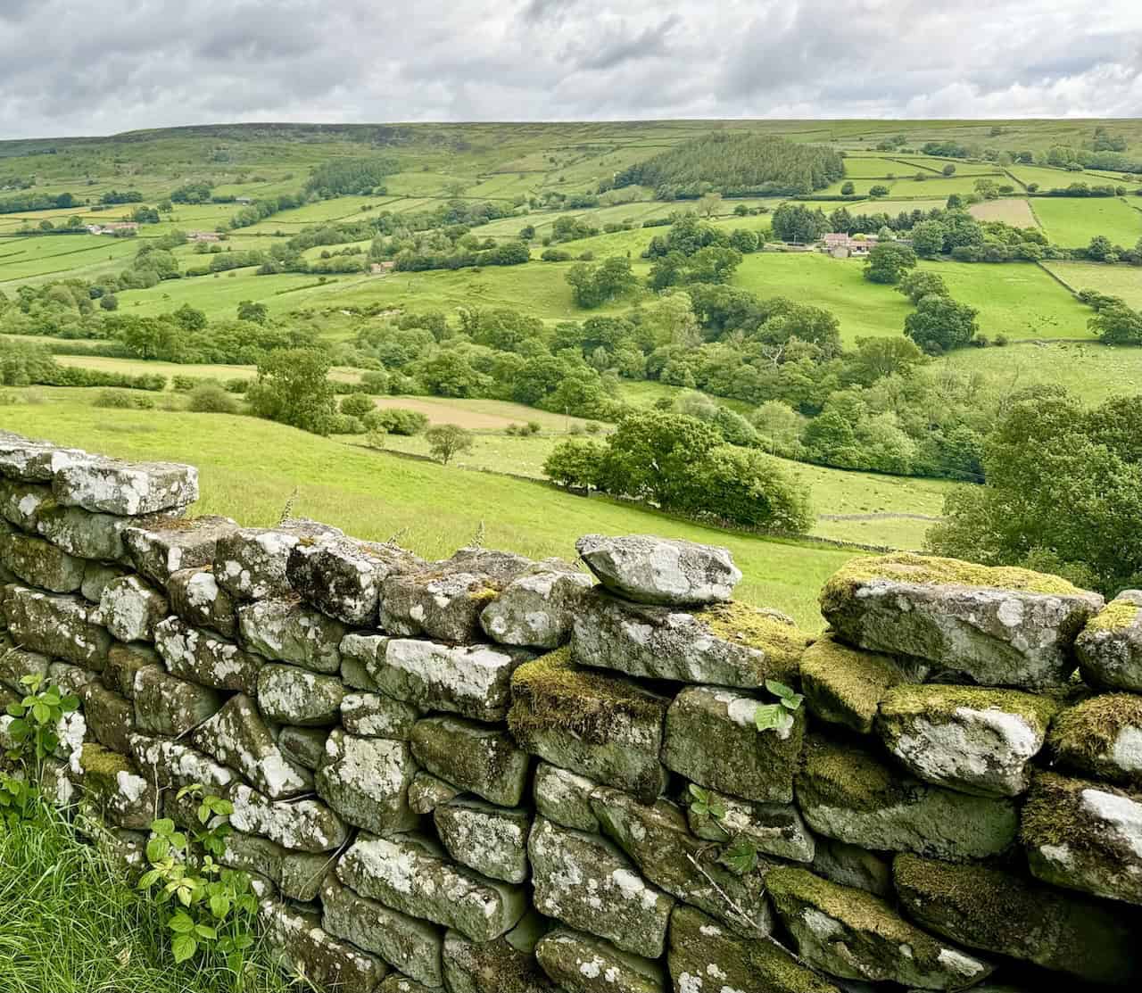
The footpath to the Quaker Burial Ground through Woodland Plantation runs alongside a fantastic moss-covered dry stone wall on the right.

At the entrance to the Quaker Burial Ground, a stone plaque embedded in the wall is dedicated to the Lowna Burial Ground. The plaque is old and weathered, with some moss or lichen growing around it. It reads:
THE RELIGIOUS
SOCIETY OF FRIENDS (QUAKERS)
LOWNA
BURIAL GROUND
BETWEEN THE YEARS
1675 AND 1837 THERE WERE
BURIED HERE 114 FRIENDS


Fifty Walks Across the Beautiful North York Moors National Park
AD Discover 50 routes across the North York Moors, from short easy strolls to challenging high-level hikes. With OS maps, route descriptions, and local highlights, it also includes the legendary 40-mile Lyke Wake Walk, described in four accessible stages.
Inside the Lowna Burial Ground, there’s a single bench where one can sit and soak in the peaceful atmosphere. This historic site, established in 1675, served as a burial ground for the Religious Society of Friends, or Quakers. Due to fierce persecution, they were denied churchyard burials and created their own burial sites on private land like this one. Between 1675 and 1854, 114 Quakers were laid to rest here.
The Religious Society of Friends emerged after the English Civil Wars of the 1640s, with George Fox founding Quakerism and travelling throughout Yorkshire in the 1650s, preaching and gathering followers. Believing in the direct individual experience of God and worshipping in silence, Quakers challenged the establishment by refusing to swear oaths or doff their hats to lords and magistrates, addressing everyone as ‘thou’. Early Friends faced fines and imprisonment, with many dying in prisons in Pickering and York. However, after 1689, nonconformists were allowed to meet freely and build their own places of worship. In 1690, a Quaker meeting house was built in West End, Kirkbymoorside, where Quakers have worshipped ever since.
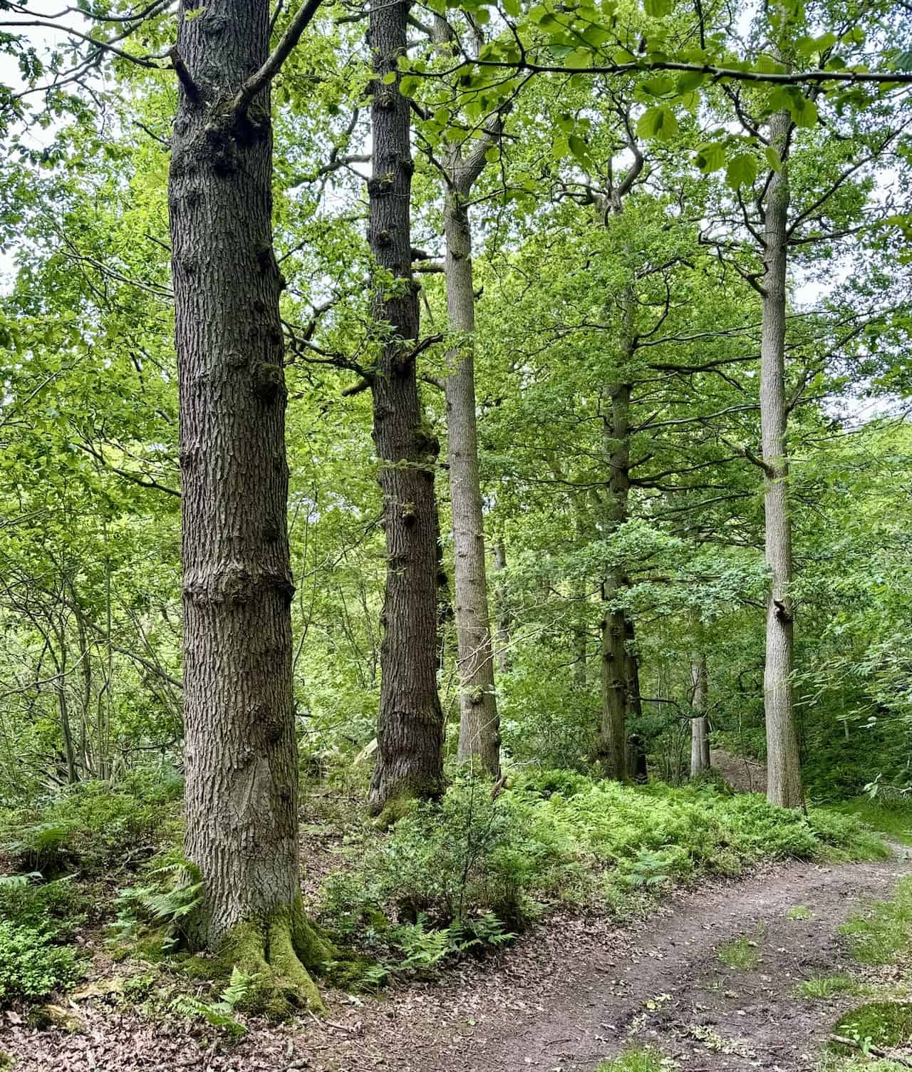
After visiting the Quaker Burial Ground, the path continues north through tranquil woodland. Keeping the dry stone wall on my right as a guide, I marvel at the gnarled branches of the trees, forming a complex network that spreads outwards and upwards.

Fifty Walks Across the Beautiful North York Moors National Park
AD Discover 50 routes across the North York Moors, from short easy strolls to challenging high-level hikes. With OS maps, route descriptions, and local highlights, it also includes the legendary 40-mile Lyke Wake Walk, described in four accessible stages.
On the way to Dale End Bridge, the narrow path mostly follows a line of telegraph poles. Although the path runs parallel to the River Dove, the dense vegetation hides it from view as it flows lower in the valley to my right.

At Dale End Bridge, the River Dove comes into view. Instead of crossing the bridge, I take the steep uphill path heading north-west, aiming for Park Farm.


Osprey Hikelite Unisex Backpack for Comfortable and Lightweight Hiking
AD The Osprey Hikelite backpack combines lightweight design with practical features, including a breathable mesh back panel, soft webbing straps, and stretch mesh water bottle pockets. With zipped storage and an organiser compartment, it is ideal for day hikes and outdoor use.
The woodland path between Dale End Bridge and Park Farm is a joy to walk along. It generally runs parallel to a moss-covered dry stone wall, with lovely trees whose branches extend from the main trunk in a complex, intricate pattern.

Between Park Farm and Cross Farm, the route offers excellent views of the Farndale valley. Scattered farms are surrounded by a patchwork of green fields and meadows, with clusters of trees and hedgerows dotting the landscape.
Osprey Hikelite Unisex Backpack for Comfortable and Lightweight Hiking
AD The Osprey Hikelite backpack combines lightweight design with practical features, including a breathable mesh back panel, soft webbing straps, and stretch mesh water bottle pockets. With zipped storage and an organiser compartment, it is ideal for day hikes and outdoor use.
The path from Cross Farm to Holly Bush Farm follows a narrow, quiet road with little traffic. Although the road leads to Low Mill, I turn left opposite Holly Bush Farm for today’s walk.

Passing through Keysbeck Farm, I head north-west to Scarth Nick, realising I am now just over one-third of the way around the Farndale walk.


Peak Bagging Wainwrights with Routes to Complete All Fells
AD This comprehensive guide offers 45 circular routes linking all 214 Wainwright fells. With maps, GPX downloads, elevation profiles, and practical advice, it provides efficient yet inspiring ways to complete this classic Lake District challenge at your own pace.
From Scarth Nick, the view north across the valley of West Gill is breathtaking. The land rises to a ridge known as Horn Ridge, peaking at 330 metres. Perched atop a dry stone wall, a Muscovy duck with its distinctive red facial caruncles and contrasting black and white plumage adds to the picturesque setting.

Looking north-west towards the head of the West Gill valley, I prepare to descend to West Gill Beck and make a U-turn to leave the valley on the other side.

Peak Bagging Wainwrights with Routes to Complete All Fells
AD This comprehensive guide offers 45 circular routes linking all 214 Wainwright fells. With maps, GPX downloads, elevation profiles, and practical advice, it provides efficient yet inspiring ways to complete this classic Lake District challenge at your own pace.
The track leads past the renovated stone building of High Barn, offering straightforward and easy walking. Heading south-east, I reach Horn End, marking the halfway point of this Farndale walk.
Passing Horn End, I admire the lovely converted farm buildings, some of which are Grade II listed. Now, these buildings offer luxury accommodation with en-suite facilities, all set in the stunning countryside of Farndale West.


Berghaus Hillmaster II GTX Men's High Rise Hiking Boots
AD The Berghaus Hillmaster II GTX men’s hiking boots feature a waterproof, breathable GORE-TEX membrane, a memory foam tongue and collar for a personalised fit, and a Vibram sole delivering exceptional grip, stability, and shock protection for confident performance on any terrain.
Low Mill, a small hamlet in Farndale, is particularly famous for the wild daffodils that bloom along the banks of the River Dove each spring. Historically, Low Mill housed a water-powered corn mill, which has now been converted into a residential property. Another notable structure is the Low Mill Bridge over West Gill Beck, an early 19th-century stone bridge characterised by its single-span, semicircular arch. The hamlet plays a significant role in the popular Farndale Daffodil walk, attracting thousands of visitors annually. This walk is particularly accessible, making it suitable for families and individuals with mobility aids.

From Low Mill, I briefly walk along Daleside Road, which is quiet with little traffic. The road passes Woodcock Bower and Tenter Hill before I turn right at Rawson Syke.

Berghaus Hillmaster II GTX Men's High Rise Hiking Boots
AD The Berghaus Hillmaster II GTX men’s hiking boots feature a waterproof, breathable GORE-TEX membrane, a memory foam tongue and collar for a personalised fit, and a Vibram sole delivering exceptional grip, stability, and shock protection for confident performance on any terrain.
The entire section of the walk between Rawson Syke and Hagg End Farm is delightful. It leads through lovely meadows, past charming farms, along woodland trails, with no significant inclines, offering splendid views of the Farndale valley. This view is from Ewecote, about three-quarters of the way through the Farndale walk.

Several signposts guide the way back to Lowna. This one is located between Thunder Head Hill and Hagg End Farm.


Kendal Mint Co Energy Gel with Citrus and Mint Flavour
AD Kendal Mint Co energy gels deliver 27g of fast-absorbing carbohydrates plus electrolytes and B vitamins for improved performance. Vegan, gluten free, and Informed Sport certified, these caffeine-free gels are refreshing, easy to digest, and ideal for running, cycling, and endurance.
The route through Hagg End Farm is picturesque, with well-kept buildings and gardens enhancing the scenery.
The forest path through Birch Hagg Plantation is enchanting. Tall, straight trees form a lush green canopy, with ferns and shrubs adorning the forest floor. The well-trodden path is perfect for walking.
Kendal Mint Co Energy Gel with Citrus and Mint Flavour
AD Kendal Mint Co energy gels deliver 27g of fast-absorbing carbohydrates plus electrolytes and B vitamins for improved performance. Vegan, gluten free, and Informed Sport certified, these caffeine-free gels are refreshing, easy to digest, and ideal for running, cycling, and endurance.
As I near the end of the forestry track, I head towards Lund Road, which leads to Lowna Road.

Almost at the end of the Farndale walk, I cross Lowna Bridge over the River Dove and look towards Surprise View Cottages, just before reaching the car park.


Thermos Stainless King Flask for Travel and Daily Adventures
AD The Thermos Stainless King 470ml flask keeps drinks hot for 18 hours or cold for 24. With durable stainless steel, vacuum insulation, a serving cup, and a leakproof design, it is perfect for commutes, journeys, and outdoor adventures.