Explore Woodland and Moorland Scenery on the Guisborough Forest Walk
Your Guisborough Forest walk begins in Pinchinthorpe, located just west of Guisborough on the A173. Park at the Guisborough Forest & Walkway Visitor Centre, where you’ll find a café and toilet facilities. From the car park, head up the ramp towards the visitor centre, then turn left. Walk past the front of the centre on your left and an old railway carriage on your right. After passing the carriage, go through the gates and continue straight ahead along the route of the old railway line. Shortly, you’ll spot a children’s play area on your left. Here, the path splits; take the right-hand route, following the Guisborough Forest green, red, and white walking trails, marked by waymarkers on a post.
Continue through a gate, now following the Guisborough Forest well-being trail. The path leads past a picnic area on your right and then reaches a crossroads. Keep going straight on, staying on the well-being trail and the blue cycle route. The track gradually ascends, passing Bousdale House on your right. Further on, ignore the left-hand path signposted to Guisborough Market Town and continue uphill towards Bousdale Wood. As you progress along the woodland track, it bends left and then right. Stay on the wide, stony path, ignoring any side routes. The track levels out briefly before climbing again through High Bousdale Wood, with signage confirming you are still on the well-being trail.
At the top of High Bousdale Wood, the track bends sharply left in a U-turn. Waymarkers indicate you are still on the blue cycle route. Follow the ascending track, and when you reach another junction, take a sharp right, continuing along the blue cycle trail. The climb continues through the woods until the main track bends left. At this point, walk straight ahead onto a narrower footpath. Follow this path, heading towards Roseberry Topping, which soon comes into view. You will enter the Roseberry Topping National Trust area—stay on the main path across Roseberry Common, avoiding side trails.

Eventually, you will reach a large gate in a dry stone wall, where the path to your left and right is the Cleveland Way. If you wish to extend your Guisborough Forest walk with a climb up Roseberry Topping, turn right here, then return to this spot. Otherwise, turn left onto the Cleveland Way, keeping the dry stone wall to your right. The path rises steeply, skirting the right side of the cone-shaped hill called Little Roseberry. Continue along the stone-stepped path to the top, where you’ll find a dry stone wall with a bench in front of it. Pass through the gate in the wall, where the path splits into three. Take the first path on the left, which runs alongside the dry stone wall.
Follow the moorland track, exiting the Roseberry Topping National Trust area and continuing straight ahead. The trail leads into Hanging Stone Wood, where the track bends sharply right. Look for a narrower footpath on the left, leading into the trees. This is a North York Moors public footpath, marked by a yellow waymarker on a wooden post. Take this route to Hanging Stone, a highlight of the Guisborough Forest walk, then retrace your steps to rejoin the main track. Turn left and follow the descending path south until it meets the Cleveland Way, where you should turn left again.

Continue along the Cleveland Way until you reach a barrier and a T-junction. Turn left, following the stony track downhill through Hutton Wood. At a crossroads, continue straight on, keeping downhill. The path narrows as it descends, eventually reaching a road. Turn left and walk along the roadside footpath as the route passes through woodland. Soon, you’ll see a large grassy field on your left. Ignore the first public footpath into this field and instead continue along the road until you reach a tarmac lane to Home Farm. Turn left here, rejoining the well-being trail and the blue cycle route.
Walk past a cluster of stone cottages and a farm on your right, then follow the track alongside the trees. The path bends left in front of Bousdale Cottages. At the next junction, turn right, following the sign for the Walkway Visitor Centre. Shortly after, where the path splits, take the lower right-hand path. When the path splits again, ignore the left turn up to Bousdale House and instead take the right-hand trail downhill, following the green, red, and white waymarkers. At the bottom, turn left onto the disused railway line and follow it all the way back to the visitor centre car park, completing your Guisborough Forest walk.
Guisborough Forest Walk: Maps and Tools
Visit either the OS Maps website or the Outdooractive website to view this walking route in greater detail. Both platforms offer a range of features, including the ability to print the route, download it to your device, and export the route as a GPX file. You can also watch a 3D fly-over and share the route on social media. Additionally, this page includes a printable version of the walk in PDF format. Plus there is a supporting video, available for you to watch on YouTube.
Guisborough Forest Walk: Distance, Duration, Statistics
Distance: 7 miles
Distance: 11 kilometres
Duration: 3½ hours
Ascent: 1176 feet
Ascent: 358 metres
Type: Circular walk


Walking in the Yorkshire Dales with 43 Circular Routes
AD This Cicerone guidebook includes 43 circular walks exploring valleys, hills, and moors between Kirkby Stephen and Pateley Bridge. With OS maps, local highlights, and routes ranging from 3–11 miles, it is a year-round companion for walkers of all abilities.
Recommended Ordnance Survey Map
The best map to use on this walk is the Ordnance Survey map of the North York Moors Western Area, reference OS Explorer OL26, scale 1:25,000. It clearly displays footpaths, rights of way, open access land and vegetation on the ground, making it ideal for walking, running and hiking. The map can be purchased from Amazon in either a standard, paper version or a weatherproof, laminated version, as shown below.
About the Guisborough Forest & Walkway
The Guisborough Forest & Walkway is located at the north-west edge of the North York Moors National Park, just five minutes from Guisborough market town, on the A173 in Pinchinthorpe. The site offers excellent visitor facilities, including a café, visitor centre, toilets, picnic area, and children’s play area. Entry is free, though parking is available in a pay-and-display car park.
Exploring Guisborough Forest
Owned by Forestry England, Guisborough Forest spans approximately 233 hectares (577 acres), rising steeply from the southern edge of Guisborough up onto the North York Moors. The forest features a network of paths and tracks, making it a popular destination for walking and cycling.
In addition to the Guisborough Forest walk described on this page, the forest offers three waymarked walking trails and a blue-graded cycle route, all clearly signposted at junctions:
- Green trail – approximately 1½ miles (2.4 km)
- Red trail – approximately 2½ miles (4 km)
- White trail – approximately 3¾ miles (6 km)
- Blue-graded cycle route – approximately 4½ miles (7.2 km)
For those looking to unwind in nature, the forest also features a newly created well-being trail, just over 3 miles (4.8 km) long. The trail includes themed panels encouraging visitors to pause, notice, and connect with the natural surroundings. Research has shown that spending time in forests and engaging with nature can boost both mental and physical well-being.
Guisborough Forest Sculpture Trail
A 1-mile (1.6 km) sculpture trail, particularly popular with children, runs along the old railway line eastward from the visitor centre. This trail features a series of wood carvings sculpted by local tree surgeon and artist Steve Iredale, adding a creative and interactive element to the woodland experience.
The History of Guisborough Walkway
The Guisborough Walkway follows a 2½-mile (4 km) route along a section of the former Guisborough Branch Railway line, running west towards Nunthorpe and east into Guisborough Forest.
In 1850, ironstone was discovered in the hills around Guisborough. Entrepreneur Joseph Pease and his son, also named Joseph, purchased mineral rights to Cod Hill, just south of Guisborough. To transport the extracted minerals, Pease required a railway, and on 17 June 1852, Royal Assent was granted for the construction of a Middlesbrough to Guisborough railway line.
Originally, the Guisborough spur was planned to terminate at Hutton Gate, where a private station was built to serve Hutton Hall, the home of Joseph Pease. Pease ceremonially cut the first sod of earth on 30 October 1852, and the Guisborough Branch Railway line opened for mineral transport on 11 November 1853. Passenger services began on 25 February 1854, and by the 1930s, the line was running up to 11 passenger trains per day.
The railway eventually closed in the 1960s, and by the 1980s, the tracks had been removed, allowing nature to reclaim the route. The disused line became a haven for wildlife, and in 1984, Cleveland County Council transformed it into a walkway and bridleway with the agreement of British Rail. The visitor centre was later constructed in 1986, providing a hub for those exploring this historic and scenic landscape.
Guisborough Forest Walk: My Photos
Shortly after leaving the Guisborough Forest & Walkway Visitor Centre, I join the well-being trail. These trails, introduced by Forestry England across their forests in the United Kingdom, encourage visitors to immerse themselves in nature. Scientific studies show that spending time among trees and observing the natural world significantly boosts both mental and physical health.


Grisport Unisex Adult Peaklander Hiking Boots
AD The Grisport Unisex Adult Peaklander Hiking Boots are crafted in Italy with a durable waxed leather upper, Spotex breathable lining, and a reliable Track-on rubber sole. Waterproof and weighing just 1120g, they offer comfort, resilience, and dependable performance on demanding trails.
I follow the well-being trail through High Bousdale Wood, where themed panels along the route invite me to pause, reflect, and connect with the forest environment. The peaceful atmosphere makes this section of my Guisborough Forest walk particularly enjoyable.

Leaving High Bousdale Wood behind, I follow the path south towards the distinctive peak of Roseberry Topping, which stands prominently on the horizon.
Grisport Unisex Adult Peaklander Hiking Boots
AD The Grisport Unisex Adult Peaklander Hiking Boots are crafted in Italy with a durable waxed leather upper, Spotex breathable lining, and a reliable Track-on rubber sole. Waterproof and weighing just 1120g, they offer comfort, resilience, and dependable performance on demanding trails.
As the path ascends across Roseberry Common, I pause to take in the sweeping views to the north. Redcar is visible in the distance, along with the wind turbines of Teesside Wind Farm spinning in the North Sea. Industrial Teesside unfolds before me, with Middlesbrough, Billingham, and the mouth of the River Tees all in view.

Deciding to take a detour, I make my way towards Roseberry Topping. At its base, an information board explains that over the coming years, a team of specialists, along with staff and volunteers from the National Trust and North York Moors National Park, will be undertaking extensive repairs on ten public and permissive routes around the hill.


Fifty Walks Across the Beautiful North York Moors National Park
AD Discover 50 routes across the North York Moors, from short easy strolls to challenging high-level hikes. With OS maps, route descriptions, and local highlights, it also includes the legendary 40-mile Lyke Wake Walk, described in four accessible stages.
I begin my ascent. While some routes remain in need of repair, the path I’m following is in good condition. Due to heavy foot traffic, erosion has affected several trails around Roseberry Topping, but this one has been reinforced with paving stones and large cobbled steps to preserve the hillside.

The stone-stepped path zigzags up the hillside, offering breathtaking views as I climb higher. The ascent is steep but rewarding.

Fifty Walks Across the Beautiful North York Moors National Park
AD Discover 50 routes across the North York Moors, from short easy strolls to challenging high-level hikes. With OS maps, route descriptions, and local highlights, it also includes the legendary 40-mile Lyke Wake Walk, described in four accessible stages.
Nearing the summit, I glance down and spot the village of Newton under Roseberry nestled below. In the distance, Middlesbrough, Billingham, Hartlepool, the Tees Mouth, and the vast expanse of the North Sea stretch out before me. Roseberry Topping is a popular destination, and I see plenty of walkers making their way up Roseberry Lane from the village.
At last, I reach the summit. The white triangulation pillar stands at 320 metres, marking the highest point. From here, the panoramic views extend in all directions, showcasing the stunning countryside surrounding this iconic hill.


Osprey Hikelite Unisex Backpack for Comfortable and Lightweight Hiking
AD The Osprey Hikelite backpack combines lightweight design with practical features, including a breathable mesh back panel, soft webbing straps, and stretch mesh water bottle pockets. With zipped storage and an organiser compartment, it is ideal for day hikes and outdoor use.
I make my way down Roseberry Topping, retracing my steps along the same cobbled stone path. The carefully laid stones make for a steady descent, helping to prevent further erosion. Below me, I can clearly see the dry stone wall and the path running alongside it, which I will soon be following. The valley stretches out ahead, offering a clear and inviting route back towards the next stage of my Guisborough Forest walk.

As I descend, I look across Roseberry Common towards the north-east. In the distance, Guisborough comes into view, along with Errington Wood, just south of Marske-by-the-Sea. The scenery is a reminder of how varied and beautiful my Guisborough Forest walk truly is.

Osprey Hikelite Unisex Backpack for Comfortable and Lightweight Hiking
AD The Osprey Hikelite backpack combines lightweight design with practical features, including a breathable mesh back panel, soft webbing straps, and stretch mesh water bottle pockets. With zipped storage and an organiser compartment, it is ideal for day hikes and outdoor use.
Following the cobbled path as it zigzags down the hillside, I take in my surroundings. This part of the walk is a highlight, offering both scenic beauty and a sense of tranquillity.

At the base of Roseberry Topping, I join the Cleveland Way, keeping to the path beside the dry stone wall as I head east towards Little Roseberry, a distinctive cone-shaped hill. Instead of taking the direct, eroded route to the top, I follow the well-maintained stone path that skirts around its right-hand side.


Peak Bagging Wainwrights with Routes to Complete All Fells
AD This comprehensive guide offers 45 circular routes linking all 214 Wainwright fells. With maps, GPX downloads, elevation profiles, and practical advice, it provides efficient yet inspiring ways to complete this classic Lake District challenge at your own pace.
Like some of the repaired routes around Roseberry Topping, this section of the path around Little Roseberry has been reinforced with large stone slabs, preventing further erosion and making for a smooth, enjoyable walk.

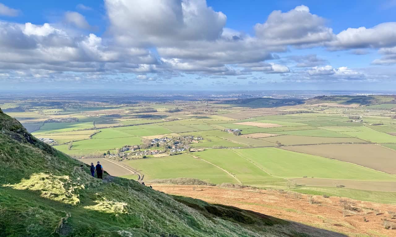
As I follow the path around Little Roseberry, I glance back to take in an incredible view of Roseberry Topping. From this vantage point, the people at the summit appear as tiny as ants against the sky.

Peak Bagging Wainwrights with Routes to Complete All Fells
AD This comprehensive guide offers 45 circular routes linking all 214 Wainwright fells. With maps, GPX downloads, elevation profiles, and practical advice, it provides efficient yet inspiring ways to complete this classic Lake District challenge at your own pace.
Leaving Little Roseberry behind, I follow a scenic path towards Hanging Stone. This is one of my favourite parts of the Guisborough Forest walk, offering far-reaching views. Looking north-west, I can see Middlesbrough, while below me, the dense woodland of Hanging Stone Wood stretches out.

From the same path, I take in a westward view towards Roseberry Topping, its distinctive peak standing out against the landscape.


Berghaus Hillmaster II GTX Men's High Rise Hiking Boots
AD The Berghaus Hillmaster II GTX men’s hiking boots feature a waterproof, breathable GORE-TEX membrane, a memory foam tongue and collar for a personalised fit, and a Vibram sole delivering exceptional grip, stability, and shock protection for confident performance on any terrain.
Further along, I turn my gaze north towards Redcar, where the wind turbines on the coastline are clearly visible, creating a striking contrast against the sea.

The walk towards Hanging Stone is wonderfully easy-going. The flat, well-trodden path makes this section of my Guisborough Forest walk a relaxing and thoroughly enjoyable experience.

Berghaus Hillmaster II GTX Men's High Rise Hiking Boots
AD The Berghaus Hillmaster II GTX men’s hiking boots feature a waterproof, breathable GORE-TEX membrane, a memory foam tongue and collar for a personalised fit, and a Vibram sole delivering exceptional grip, stability, and shock protection for confident performance on any terrain.
Where the track bends sharply to the right, I take a narrower footpath on the left, leading into the trees. This is a designated North York Moors public footpath, marked with a yellow waymarker on a wooden post.

Before long, I arrive at Hanging Stone. From this natural sandstone outcrop, I enjoy a breathtaking vantage point over Guisborough, Errington Wood, and the distant North Sea. It’s a perfect spot to pause for a break, especially in good weather.


Kendal Mint Co Energy Gel with Citrus and Mint Flavour
AD Kendal Mint Co energy gels deliver 27g of fast-absorbing carbohydrates plus electrolytes and B vitamins for improved performance. Vegan, gluten free, and Informed Sport certified, these caffeine-free gels are refreshing, easy to digest, and ideal for running, cycling, and endurance.
Looking east, I spot Highcliff Nab about 1½ miles away. That was my destination on my Guisborough 3 Peaks walk, but today, I won’t be heading that far.

After taking in the views from Hanging Stone, I rejoin the Cleveland Way. This stretch of the trail runs along the edge of Hutton Moor, with Highcliff Nab visible straight ahead in the distance.
Kendal Mint Co Energy Gel with Citrus and Mint Flavour
AD Kendal Mint Co energy gels deliver 27g of fast-absorbing carbohydrates plus electrolytes and B vitamins for improved performance. Vegan, gluten free, and Informed Sport certified, these caffeine-free gels are refreshing, easy to digest, and ideal for running, cycling, and endurance.
My route back to the visitor centre follows part of the Guisborough Walkway, which runs along a section of the former Guisborough Branch Railway line. Along the way, I admire several woodland sculptures created by artist Steve Iredale, depicting various woodland creatures hidden among the trees.


Thermos Stainless King Flask for Travel and Daily Adventures
AD The Thermos Stainless King 470ml flask keeps drinks hot for 18 hours or cold for 24. With durable stainless steel, vacuum insulation, a serving cup, and a leakproof design, it is perfect for commutes, journeys, and outdoor adventures.
As I near the end of my Guisborough Forest walk, I pass the iconic railway carriage at the visitor centre, a well-known landmark in the area.

Finally, to conclude my walk, I stop by the Branch Walkway Café at the Guisborough Forest & Walkway Visitor Centre for a well-earned coffee before heading back to the car park.
Thermos Stainless King Flask for Travel and Daily Adventures
AD The Thermos Stainless King 470ml flask keeps drinks hot for 18 hours or cold for 24. With durable stainless steel, vacuum insulation, a serving cup, and a leakproof design, it is perfect for commutes, journeys, and outdoor adventures.