ADVERTISEMENT
How to Enjoy the Guisborough Woods Walk Through Forest and Moorland
Your Guisborough Woods walk begins on Hutton Village Road, accessible from the junction of The Avenue and Hutton Lane on the south-west side of Guisborough. You’ll find a section of roadside parking on a bend roughly halfway between the main road and Hutton Village itself. Most walkers leave their cars near the top of the lane that leads to Timber House, Lowcross House, Park House, and School House.
Start your walk by heading along the footpath that runs beside Hutton Village Road, making your way towards Hutton Village. Shortly after passing the Hutton Village sign, which is mounted on a concrete block, the road bends to the left. At this bend, take the footpath on the right-hand side, signposted to Kildale and Commondale.
This path climbs steeply uphill through Hutton Wood for about one third of a mile (0.5 kilometres) until you reach a crossroads. Continue straight ahead here, following the track marked as part of the National Cycle Network. Keep climbing through the woods for almost another half a mile (0.8 kilometres) until you reach a second crossroads at the edge of the woodland.
Go through the gate and carry on straight ahead onto Hutton Moor, now following the bridleway, which is also part of the Cleveland Way National Trail. Continue along the stony track a little further uphill, then take a left turn onto a paved footpath, still following the Cleveland Way. This is clearly marked with the acorn symbol, which identifies all national trails.
As you cross the open moorland, the path begins to dip down into a hollow and meets a dry stone wall. Keep the wall on your left-hand side and continue along the path for approximately one mile (1.6 kilometres), heading in the direction of Highcliff Nab. Ignore the footpath on your left that leads to Highcliffe Farm and stay with the wall as it curves left towards the trees.

ADVERTISEMENT
As you reach the tree line, ignore the first left-hand bridleway and instead take the second left, a footpath signposted once again as the Cleveland Way. This path leads you into the woodland. Keep following it with the dry stone wall still on your left until you arrive at a wooden post bearing a yellow public footpath arrow alongside the Cleveland Way acorn symbol. Turn right here.
Climb the hill, following the acorn waymarkers, and you’ll soon reach the base of Highcliff Nab. Turn right and take the steps up to the summit, where you’ll be rewarded with stunning views over Guisborough town centre. Once at the top, turn right and continue along the Cleveland Way, walking along the ridge.
Before long, you’ll join a wider stone forestry track. Turn left and walk eastwards, continuing your Guisborough Woods walk. Walk for around one and a half miles through Guisborough Woods (2.4 kilometres), staying on the Cleveland Way, which is clearly marked with wooden posts and fingerposts bearing the national trail acorn symbol.
Eventually, you’ll come to a quiet grassy clearing on your left, marked by three pine trees. This peaceful spot, which sits above a disused quarry (visible on Ordnance Survey maps but not from the ground), marks the approximate halfway point of your Guisborough Woods walk.
Pass the clearing and continue steeply downhill on the grassy track. When the Cleveland Way branches off to the right, do not follow it. Instead, carry on straight ahead, descending sharply for about a quarter of a mile (0.4 kilometres). The track soon makes a sharp U-turn to the left – follow it around and continue for another half a mile (0.8 kilometres), where it bends again, this time with a sharp right-hand U-turn.

ADVERTISEMENT
Carry on downhill until you reach the edge of the woodland. A gate lies ahead, with open farmland beyond. Here, turn left and follow the path along the woodland edge. Cross a small wooden footbridge over a stream, and continue for about a quarter of a mile (0.4 kilometres), now walking beneath Belman Bank.
You’ll arrive at a junction with several exits. Keep going straight ahead, following signs for the Walkway Visitor Centre. Walk along this forestry track for around half a mile (0.8 kilometres) until you reach a T-junction, where a small brick building stands in front of you. Turn right and head downhill, then turn left at the next junction, again following signs for the Walkway Visitor Centre.
Continue for roughly two-thirds of a mile (1 kilometre), until the Cleveland Way joins the Tees Link. Keep following the signs for the Walkway Visitor Centre. After another half a mile (0.8 kilometres) through the woods, you’ll reach a fork in the track.
Here, take the public footpath to your right, which descends a set of wooden steps. At the bottom, turn left, following the yellow public footpath marker. You’ll emerge into a stretch of open grassy meadowland, with Hutton Hall on your right and, a little further along, a large wooden and brick country residence on your left.
Soon after passing this house, turn right onto the tarmac lane. Walk past Timber House, Lowcross House, Park House, and School House. This lane leads you back to Hutton Village Road, completing your Guisborough Woods walk.
Guisborough Woods Walk: Maps and Tools
Visit either the OS Maps website or the Outdooractive website to view this walking route in greater detail. Both platforms offer a range of features, including the ability to print the route, download it to your device, and export the route as a GPX file. You can also watch a 3D fly-over and share the route on social media. Additionally, this page includes a printable version of the walk in PDF format. Plus there is a supporting video, available for you to watch on YouTube.
Guisborough Woods Walk: Distance, Duration, Statistics
Distance: 7½ miles
Distance: 12 kilometres
Duration: 3¾ hours
Ascent: 1214 feet
Ascent: 370 metres
Type: Circular walk

ADVERTISEMENT
Recommended Ordnance Survey Map
The best map to use on this walk is the Ordnance Survey map of the North York Moors Western Area, reference OS Explorer OL26, scale 1:25,000. It clearly displays footpaths, rights of way, open access land and vegetation on the ground, making it ideal for walking, running and hiking. The map can be purchased from Amazon in either a standard, paper version or a weatherproof, laminated version, as shown below.
North York Moors Walking Guidebooks
The North York Moors, by Paddy Dillon, describes 50 walks of 4 to 14 miles across the Tabular Hills, Hambleton Hills, Cleveland Hills, high moors and Cleveland coast, plus the Lyke Wake Walk in four stages, with Ordnance Survey mapping and notes on transport and refreshments.
North York Moors Short Walks Made Easy, published by Ordnance Survey, brings together 10 accessible routes of 2.5 to 4.5 miles, each taking around a couple of hours, ideal for families or anyone short on time. Both books can be purchased from Amazon, as shown below.
Walking the North York Moors
The North York Moors, by Paddy Dillon, a Cicerone guidebook of 50 walks throughout the National Park
About Guisborough Woods
Guisborough Woods is a broad belt of woodland situated on the northern edge of the North York Moors National Park, immediately south of the town of Guisborough. Stretching east to west, it is bordered by the town to the north and the rising, open moorland of Gisborough Moor to the south. Interestingly, the northern boundary of the national park cuts between the town and the woodland, placing Guisborough outside the park and Guisborough Woods within it.
The woodland occupies a steep, north-facing escarpment. Elevation rises from approximately 150 metres (492 feet) near the northern edge to over 300 metres (984 feet) on the higher ground of Highcliff Nab and Gisborough Moor. Notably, while the woodland is spelt ‘Guisborough’, the moor omits the ‘u’, becoming ‘Gisborough’. One of the most prominent features is Highcliff Nab, a striking sandstone outcrop standing at around 310 metres (1017 feet). Positioned on the northern edge of the moors, it offers panoramic views over the town below. Clearly visible from Guisborough, this natural landmark is part of the Cleveland Ironstone Formation, a geological layer dating back roughly 190 million years to the Jurassic period.
Numerous springs and gills (narrow wooded valleys with streams) flow through the woods, enriching the landscape and contributing to a varied and diverse micro-topography.
The history of Guisborough Woods stretches back several centuries, deeply rooted in the medieval heritage of the region. Historically, the woodland formed part of the extensive estates owned by Gisborough Priory, an Augustinian monastery founded in 1119. This historic link established the woodland’s significance, serving both as a spiritual retreat and an economic resource during the medieval period.
Over the centuries, the woods have been carefully managed and conserved, valued not only for their natural resources but also for their role in local recreation. This long-standing stewardship represents one of the region’s earliest examples of sustainable woodland management.
In more recent times, Guisborough Woods has seen substantial changes as part of modern woodland practices. Over the past twelve years, a series of planned fellings have altered the composition and structure of the woodland, particularly in areas such as Hanging Stone Wood, Highcliff Wood, Belmanbank Gate, and Westworth Wood. These interventions have created a more varied mix of open woodland and wooded heath habitats, supporting greater biodiversity while preserving the woodland’s natural beauty.
A well-developed network of footpaths, bridleways, and woodland tracks weaves through the woods in all directions. Several footpaths connect the woodland to both the town of Guisborough and Hutton Village, providing easy access for walkers, cyclists, and riders. The Cleveland Way National Trail skirts the higher southern edge of the woodland, roughly following the line of the escarpment and offering far-reaching views across the landscape.
Guisborough Woods Walk: My Photos
The first mile or so of my Guisborough Woods walk is definitely the most challenging, as it’s pretty much uphill all the way through Hutton Wood. But once I reach the top and emerge onto Hutton Moor, the views open up and make all the effort completely worthwhile. I follow the Cleveland Way National Trail across the moorland as I head towards Highcliff Nab.

ADVERTISEMENT
Joining the Cleveland Way National Trail and looking north-east, I have Highcliff Nab in my sights. I can see the pale white and greenish rock face of the Nab, which from here is roughly a mile (1.6 kilometres) away as the crow flies. Also to the north-east, about 2 miles (3.2 kilometres) away, are the houses and buildings of the market town of Guisborough. In the distance, on Beacon Moor around 5 miles (8 kilometres) away, I can also make out Errington Wood.

The trail carries me across Hutton Moor and along a delightful path beside a dry stone wall. It’s easy to follow, and I pass Highcliffe Farm in the fields to my left. The route curves gently into the trees and leads me straight to Highcliff Nab. It’s a warm, sunny day and this part of the Guisborough Woods walk is definitely a highlight.

ADVERTISEMENT
I continue on the Cleveland Way footpath, still following the line of the wall as it bends left towards a small wooded area close to Highcliff Nab.

Under the crisp spring sunshine, the colours are really popping today. The stone path cuts cleanly through the mix of green and brown grasses and heather, with yellow gorse bushes beginning to bloom under a brilliantly bright blue sky.
ADVERTISEMENT
A signposted left turn keeps me on the Cleveland Way, guiding me towards Highcliff Nab. The path weaves through a stand of tall, bare-branched trees with smooth, silvery trunks that twist upwards.

At the base of Highcliff Nab, I stand before the striking sandstone outcrop on the northern edge of the moors above Guisborough. Easily visible from the town below, this rock formation is part of the Cleveland Ironstone Formation, a geological layer dating back to the Jurassic period around 190 million years ago.

ADVERTISEMENT
The views from the base are already impressive, but I know that a short climb to the top of Highcliff Nab will offer even better vistas.

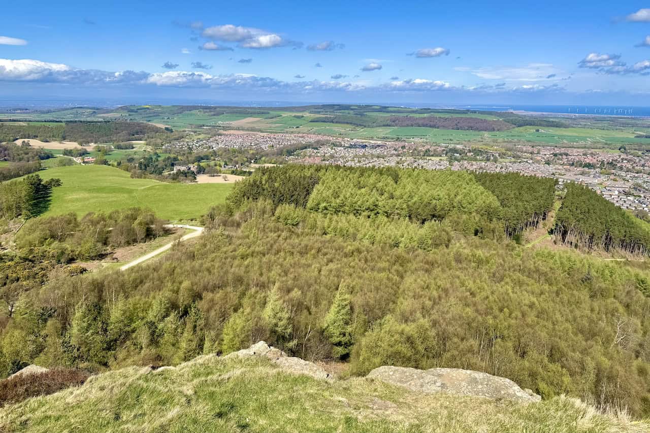
At the summit of Highcliff Nab, I’m met by a stiff breeze and astonishing clarity. Looking north, the market town of Guisborough spreads out below. Beyond it lie rural farmlands and villages such as Yearby, Wilton, Upleatham, and Dunsdale. Further out, I can clearly see the coastal town of Redcar and the turbines of Teesside Wind Farm in the North Sea, about 9 miles (14.5 kilometres) away.
ADVERTISEMENT
To the north-west, Kemplah Wood stretches out below me, followed by the houses in the western half of Guisborough. Beyond them, I can make out Lazenby Bank and Eston Nab.
Looking west, my view spans across Hutton Lowcross Woods, Hanging Stone Wood, and Hutton Moor. Just visible on the horizon is the distinctive tip of Roseberry Topping.

Leaving Highcliff Nab behind, I continue along the Cleveland Way heading east across the ridge. This section of my Guisborough Woods walk continues to offer truly breathtaking views.

ADVERTISEMENT
I now have a wide view of Highcliff Wood and the entire market town of Guisborough. The Tees Mouth is visible, and I can even make out parts of Hartlepool in the distance.

From this vantage point on the Cleveland Way, I can see some of the forestry tracks that wind their way through Guisborough Woods, and to the north-east, I spot Brotton and the North Sea.

Looking directly north, I attempt to count the wind turbines of the Teesside Wind Farm. My Ordnance Survey map tells me there are 27, arranged in three straight rows of nine. Although it’s difficult to see that layout clearly from this angle, the presence of the wind farm is unmistakable. EDF was awarded a 22-year lease in 2004 from The Crown Estate to develop this site as part of the UK’s first phase of offshore wind expansion. The wind farm, initially planned with 30 turbines, began construction in 2011 and was completed by June 2013. It’s operated by Teesside Windfarm Ltd.

ADVERTISEMENT
The Cleveland Way National Trail
Guisborough Woods has a maze of footpaths, bridleways, and forestry tracks running in every direction. It can be a bit confusing, so I choose to continue walking west to east at higher elevation by sticking with the Cleveland Way National Trail.

The Cleveland Way is well signposted through Guisborough Woods, with wooden posts and larger finger signs marked with the acorn symbol that denotes a national trail. It makes navigating this stretch of the Guisborough Woods walk easy and stress-free.

The Cleveland Way National Trail stretches for 109 miles (175 kilometres), beginning in Helmsley and ending at Filey Brigg. It skirts the western edge of the North York Moors National Park and passes through Guisborough Woods before continuing to Saltburn-by-the-Sea. From there it heads southwards as a coastal path. The section through Guisborough Woods measures around 3 miles (4.8 kilometres) from Highcliff Nab to Slapewath.

ADVERTISEMENT
As I follow the Cleveland Way through Guisborough Woods, the views remain spectacular. There are occasional sections where the trees close in, but overall, the route is highly rewarding.

The broad, sunlit track winds gently through the woods, flanked by young birch, pine, and spruce. Fresh spring growth gives the trees a soft green shimmer, and the sky above is a rich, uninterrupted blue with just a few drifting clouds.

After walking for just over 1½ miles (2.4 kilometres) from Highcliff Nab, I arrive at a beautiful, secluded grassy clearing with three pine trees. This peaceful spot marks a key point in my Guisborough Woods walk, as I’ll soon leave the Cleveland Way to head downhill.

ADVERTISEMENT
At around 250 metres (820 feet) of elevation, the views from the grassy clearing are absolutely stunning. It’s the perfect place for a break and a spot of lunch during my Guisborough Woods walk.

From this high vantage point, I can see Gisborough Hall nestled among the trees. Interestingly, although the town is spelt ‘Guisborough’, the hall is spelt without the ‘u’. Built in 1856 for the Chaloner family, this Grade II listed Victorian country house was designed in the Jacobean Revival style and now operates as a luxury hotel.

Leaving the Cleveland Way behind, I make my way downhill along a lovely woodland path. Spring is in full swing, with bright yellow gorse bushes lighting up the route.

Still descending, I pass through an area called West Banks. My aim is to reach the northern edge of Guisborough Woods, where the woodland gives way to open arable farmland.
ADVERTISEMENT
I reach the bottom of the hill and step out from Guisborough Woods. The landscape opens up, offering clear views of the fields, distant Errington Woods, and the Teesside Wind Farm on the horizon.

Following the footpath along the edge of Guisborough Woods, I enjoy more fantastic views, even though I’m now at a much lower elevation—around 150 metres (492 feet). To my right are the beige buildings and playing fields of Laurence Jackson School, a coeducational secondary academy serving students aged 11 to 16.

I carry on along the northern perimeter of Guisborough Woods, now passing below an area known as Belman Bank. I’m really enjoying this part of my Guisborough Woods walk.

Belman Bank gives a slightly lower but still lovely perspective of Guisborough. I stop to rest on a handy bench.

ADVERTISEMENT
Passing a weathered cluster of red-brick farm buildings lit by the afternoon sun, I notice their crumbling walls and aged roofs. In the background, modern rooftops from a nearby housing estate in Guisborough rise into view. Above, streaks of wispy cloud stretch across a brilliant blue sky.

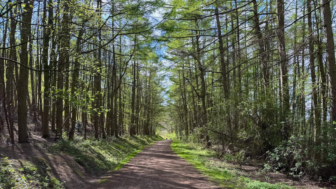
With not much further to go, I walk along a wide forestry track with signposts to the Walkway Centre. The tall conifers lining the route stand in neat rows, their spring needles filtering the sunlight and casting soft shadows on the reddish-brown path.
Almost at the end of my Guisborough Woods walk, I pass Hutton Hall, a Victorian country house set among green pastures on the edge of Guisborough. Built in the 1860s for industrialist Joseph Pease, the hall features Gothic and Jacobean Revival styles. Its red brickwork, ornate stone detailing, and formal gardens stand as a proud reminder of Guisborough’s 19th-century industrial heritage. Now privately owned, it remains one of the area’s most striking historic buildings.

ADVERTISEMENT