ADVERTISEMENT
Follow a Stunning Kettlewell Walk Through Yorkshire Dales Hills and Valleys
Begin your Kettlewell walk in the Yorkshire Dales National Park car park, located in the centre of Kettlewell village. From the car park, turn right onto the main road and cross the bridge over the River Wharfe. Ignore the first right turn immediately after the bridge and instead continue along the grass verge for a short distance until you reach a sign for the ‘Permissive Path Avoiding The Road’.
Follow this permissive footpath heading south until you join a public footpath signposted to Hawkswick. Shortly afterwards, the path forks. If you fancy a short detour, take the left-hand fork which leads to a lime kiln. Otherwise, keep to the right-hand fork and stay on the public footpath, which climbs steadily through woodland up the hillside. The route here is well-trodden and easy to follow.
As you emerge from the trees, the path opens out into a large grassy meadow. Continue climbing uphill, aiming for the left-hand corner of the field. In this corner, the path bends sharply to the right and then left, where you’ll need to cross a wall using a ladder stile.
From the stile, keep to the grassy path as it continues to ascend gently southwards for about two-thirds of a mile (1 kilometre). At the top, you’ll reach another dry stone wall. Cross over using the ladder stile and carry straight on along the grassy path, which now begins to descend into the Littondale valley. The path soon curves to the right and leads you downhill for around three-quarters of a mile (1.2 kilometres) until you reach Hawkswick.
Upon reaching the minor road in Hawkswick, turn right and follow it through the hamlet. Continue along the road until you leave the settlement, then turn left at the signpost for Out Gang Lane and Arncliffe. Cross the River Skirfare using the footbridge, then immediately turn right to follow the riverside path through Littondale.

ADVERTISEMENT
This stretch of your Kettlewell walk takes you alongside the River Skirfare for roughly 1½ miles (2.4 kilometres). Due to the river’s meanders, the path occasionally leaves the riverbank and crosses open fields, but it remains well defined and easy to follow. You’ll find a number of helpful waymarkers, including signposts and yellow-topped posts, guiding you towards Arncliffe.
As you approach the eastern edge of Arncliffe, you’ll spot the Old Vicarage ahead. Follow the path around the right-hand side of this large manor house and go through the gate. Continue on past St Oswald’s Church, which will be on your right, and turn left when you reach the minor road.
Stay on this road, passing an old schoolhouse on your left, until you arrive at Arncliffe’s village green. Turn right and walk along the road through the village. At the far end, turn right onto a bridleway just before the stone packhorse bridge that crosses Cowside Beck.
Follow the bridleway alongside a dry stone wall as it curves to the right and meets a minor road. Turn left here and cross the River Wharfe using the three-arched stone bridge. Stay on the road as it bends to the left, following signs for Litton and Halton Gill. When you reach the farm at Old Cotes, turn right onto a bridleway signposted to Starbotton.
This section of your Kettlewell walk involves a challenging uphill climb along the bridleway to reach the rocky outcrops of Brayshaw Scar. After passing Brayshaw Scar, continue uphill for about one-third of a mile (500 metres) until you reach a dry stone wall and spot a farmhouse ahead.

ADVERTISEMENT
Go through the gate in the wall but avoid the stony track that curves left towards the farmhouse. Instead, take the grassy bridleway on your right and continue uphill for another half a mile (800 metres). At the top, go through a small gate in the wall and carry straight on.
The path now runs alongside a damaged dry stone wall and begins to descend into Wharfedale. Continue downhill on the grassy bridleway for over half a mile (1 kilometre) until you reach a gate in another wall, where you’ll see a three-fingered signpost. Go through the gate and turn left, following the bridleway downhill.
The village of Starbotton and the River Wharfe will soon come into view below you. Keep following the stony path as it winds through woodland. On emerging from the trees, continue straight ahead along the path by a dry stone wall, heading towards the footbridge across the River Wharfe.
When you reach the bridge, you have the option to cross and visit Starbotton for refreshments at the Fox & Hounds. Otherwise, turn right and follow the riverside path which forms part of the Dales Way. This final leg of your Kettlewell walk follows the River Wharfe for almost two miles (3.2 kilometres).
Helpful signposts and waymarkers will keep you on track. Eventually, the path leads you back to the main road in Kettlewell. Turn left here and cross the road bridge once more to return to the car park, where your rewarding Kettlewell walk comes to an end.
Kettlewell Walk: Maps and Tools
Visit either the OS Maps website or the Outdooractive website to view this walking route in greater detail. Both platforms offer a range of features, including the ability to print the route, download it to your device, and export the route as a GPX file. You can also watch a 3D fly-over and share the route on social media. Additionally, this page includes a printable version of the walk in PDF format. Plus there is a supporting video, available for you to watch on YouTube.
Kettlewell Walk: Distance, Duration, Statistics
Distance: 9 miles
Distance: 14½ kilometres
Duration: 4¾ hours
Ascent: 1759 feet
Ascent: 536 metres
Type: Circular walk

ADVERTISEMENT
Recommended Ordnance Survey Map
The best map to use on this walk is the Ordnance Survey map of the Yorkshire Dales Northern & Central Area, reference OS Explorer OL30, scale 1:25,000. It clearly displays footpaths, rights of way, open access land and vegetation on the ground, making it ideal for walking, running and hiking. The map can be purchased from Amazon in either a standard, paper version or a weatherproof, laminated version, as shown below.
Standard Version
Yorkshire Dales Walking Guidebooks
Walking in the Yorkshire Dales: North and East, by Dennis Kelsall, describes 43 circular day walks of 3 to 12 miles across the Howgills, Mallerstang, Swaledale, Wensleydale, Coverdale and Nidderdale, with Ordnance Survey mapping and notes on parking and refreshments.
15 Short Walks in the Yorkshire Dales, by Jonathan and Lesley Williams, covers the area around Sedbergh, Kirkby Lonsdale and Ingleton. Its 15 routes of 1 to 7 miles each take under three hours, ideal for families or a relaxed half day out. Both books can be purchased from Amazon, as shown below.
Walking the Yorkshire Dales
About Kettlewell
The Anglo-Saxons named this place Cetel Wella, which means a bubbling spring or stream. They also left evidence of their farming methods, visible in the faint terracing on the fields to the south of the village. In 1320, Kettlewell received a market charter. Later, during the 17th century, lead mining brought further prosperity to the village. By the time the mines closed in the late 19th century, Kettlewell had already begun attracting visitors. Since then, its reputation as a welcoming and scenic destination has continued to grow.
Kettlewell Scarecrow Festival
Each summer, Kettlewell transforms for a few days with the appearance of over 100 life-size scarecrows in all shapes and varieties. Local people craft these scarecrows with great creativity. As a result, visitors come from far and wide to admire them and follow the popular scarecrow trail around the village.
Dark Age Woman
In 1997, workers digging near Kettlewell discovered the remains of a Dark Age burial. They uncovered the skeleton of a woman buried in a crouched position. She lived in the village around 1400 years ago and likely counted among its earliest inhabitants.
The Kettlewell with Starbotton Millennium Wall Hanging
Local residents, inspired by similar projects in other villages, decided to create their own wall hanging to mark the millennium. With support from Rural Arts North Yorkshire, the project began to take shape. People of all ages worked together to stitch a unique record of the area’s history, places, customs and natural environment. Today, the wall hanging remains on display in the village hall.
Kettlewell Walk Lime Kilns
Farmers in the Yorkshire Dales improved the thin, acidic soil by spreading lime on it. For centuries, they built field kilns to burn limestone rock and produce the necessary lime. As a result, the green ‘intake’ fields, improved over the years, stand out clearly against the rough grazing found on the higher fells.
Related Walk: Similar to the Kettlewell Walk
Visit the Polish Memorial Cross on your Buckden Pike walk in the Yorkshire Dales
Lead Mining Industry
The hills surrounding Kettlewell contain many old mine shafts. During the 18th and 19th centuries, workers mined lead here, and many of the village’s small cottages housed the miners and their families. Nearby, workers processed the lead at the local smelt mill, which was eventually demolished in 1942. The lead industry brought prosperity to the area. At one point, Kettlewell had four public houses, three of which still serve locals and visitors today.
St Mary’s Church
Soon after the Norman Conquest, in the early 12th century, villagers built the first church in Kettlewell. Only the original ‘tub’ font survives from that time. In 1820, builders replaced the old church with the one seen today. Inside, a manuscript dating from 1338 refers to the period when Coverham Abbey, near Leyburn, owned the manor.
Dowber Gill
A steep climb out of the village leads along Dowber Gill, one of the most productive lead mining areas near Kettlewell. In 1862, the Providence Mining Company struck a rich vein there. Over the next nine years, miners extracted more than 800 tonnes of ore.
Kettlewell Stocks
Beside the village war memorial stands a restored set of stocks. In mediaeval times, many villages used stocks to punish drunks or vagrants. Authorities would imprison offenders by their wrists and ankles for several days. Passers-by would then often subject them to verbal abuse and, occasionally, rotten fruit.
Kettlewell Walk: My Photos
I begin my Kettlewell walk at the Yorkshire Dales National Park car park in the heart of Kettlewell. From here, I cross New Bridge, which spans the River Wharfe. The Wharfe stretches for around 65 miles (105 kilometres) and begins at Beckermonds, approximately 9 miles (14 kilometres) north-west of Kettlewell, where Oughtershaw Beck and Green Field Beck meet in Langstrothdale.

ADVERTISEMENT
Just south of the bridge, I join a permissive path that keeps me safely off the road. It guides me towards the start of a public footpath beneath Gate Cote Scar. As I gain a little height, I glance back and take in a lovely view of the River Wharfe, New Bridge, and the village of Kettlewell nestled below.

Knipe Scar Lime Kiln
At the start of the public footpath, I spot a sign for ’Lime Kiln’ and decide to follow the secondary trail for a short detour. The path leads me to Knipe Scar Lime Kiln, built in the 1790s. Limestone was quarried nearby and burnt here to produce lime until the 1880s. A small team worked both the quarry and the kiln. Once the stone had been extracted, it was often broken down by women and boys to prepare it for burning.

ADVERTISEMENT
The ‘wheeler’ would then transport the broken stone down the track to the top of the kiln using a barrow. Lime burning was a filthy, dangerous job—not for the faint-hearted. Workers faced choking fumes, dizziness, and sickness from the fire and smoke. Limestone dust irritated the eyes and lungs, while the lime itself burned exposed skin.

To begin the burning process, limestone (brought from mines on the moor above Kettlewell) and coal were layered into the kiln over a base of kindling. The burn had to be slow and steady until the fuel was gone and ‘lump lime’ remained in the draw hole. It took real skill to judge when the burn was complete. Once cooled, the lime was loaded onto packhorses or carts. It’s a fascinating bit of history to encounter during my Kettlewell walk.

ADVERTISEMENT
Inside the kiln, I spot the name ’Benjamin North of Wortley, Leeds’ stamped onto the firestones around the arch of the draw hole. He re-lined the bowl with fire bricks in 1870—a clear marker of the kiln’s later working life.

By the 1860s, small kilns like this one at Knipe Scar were in decline. They couldn’t compete with the larger operations near Settle and Ingleton. Better roads and the arrival of the railways meant rural communities could source cheaper lime from elsewhere. The kiln had ceased operation by the late 1870s. Over a century later, it was restored: the right-hand side rebuilt in 1986 and the left consolidated in 2008.

ADVERTISEMENT
Leaving the lime kiln behind, I rejoin the public footpath and begin the steady climb up the hillside. Off to my left is a spectacular view of Kettlewell, tucked into the valley and surrounded by green fields, each enclosed by neat dry stone walls. Behind the village rises Cam Pasture, and further to the right, the long ridge of Great Whernside.
Further up, I enter a wide, grassy meadow and keep climbing. I follow the line of a dry stone wall, curving up towards the trees and into the top left-hand corner of the field. The landscape begins to open up as I gain more height on this leg of the Kettlewell walk.

ADVERTISEMENT
The path leads me uphill around the south-eastern edge of Middlesmoor Pasture. After crossing a dry stone wall, I’m instantly rewarded with a stunning view into Littondale—a real highlight of today’s walk.

As I begin to descend, I look down into Littondale and watch the River Skirfare gently winding its way along the valley floor. On the opposite side of the dale stands Hawkswick Clowder, a broad slope of mixed pasture and moorland that adds real character to the scene.

The path continues downhill into Littondale, and soon the hamlet of Hawkswick comes into view—my next destination. It’s a beautiful section of my Kettlewell walk, with each step offering fresh perspective on the surrounding hills and open countryside.

ADVERTISEMENT
I arrive in Hawkswick and take a slow wander through the hamlet. It’s wonderfully peaceful here. Traditional Yorkshire Dales cottages, built from local stone, line the narrow lane—some lime-washed, others bare, all with slate roofs and neatly kept front gardens. Daffodils and primroses brighten the verges, and pots of spring flowers sit by the doors. There’s a timeless charm in every detail.

As I carry on through Hawkswick, I pass a handsome, more formal stone house at the far end of the hamlet. Possibly Georgian or early Victorian in style, it has a symmetrical façade, sash windows, and finely dressed stonework. It has the air of a former landowner’s residence or a prosperous farmer’s home. Under the blue sky, the building glows with warmth and character.

Just beyond the hamlet, I turn left onto a public footpath leading to Out Gang Lane and Arncliffe. I cross the River Skirfare via a green-painted metal footbridge, which has a lattice truss design and enclosed wooden fencing—clearly built for walkers rather than vehicles.
ADVERTISEMENT
Standing on the bridge, I pause to take in the view upstream along Littondale. The river is tinged with an orangey-brown hue, common in upland areas where the water picks up peat from the surrounding moorland. It’s another subtle feature of the natural landscape I’ve come to appreciate during my Kettlewell walk.

After crossing the bridge, I join one of the most scenic riverside paths in the Yorkshire Dales. The route runs alongside the River Skirfare, following the floor of Littondale. The water glistens in the sunlight today, moving smoothly and reflecting the bright blue of the sky.

A little further on, the river widens and curves gently around a stony area—a sort of shingle bank formed by gravel and pebbles. These features are typical of upland rivers, where the current slows just enough to drop its load of sediment. On the opposite bank, the limestone face of Hawkswick Moor rises sharply, rugged and fractured, giving the valley a bold, dramatic edge.

ADVERTISEMENT
Not long after the shingle bank, the River Skirfare begins to meander sharply. The outer bank of the bend is steep, where the water flows fast and erodes the land, undercutting the turf and exposing soil. On the inner bank, slower water deposits gravel and pebbles, forming a gentle shingle bar. These contrasts in erosion and deposition give the meander its characteristic shape.
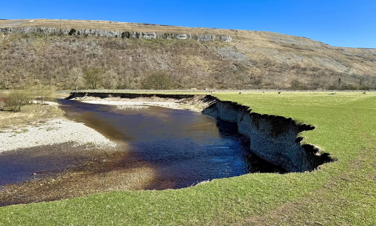
The surrounding land is part of the river’s floodplain, shaped by centuries of seasonal flooding. It’s fertile, lush, and perfect for grazing. In the field, sheep wander with their new lambs. Behind them, the craggy limestone escarpment of Hawkswick Moor rises steeply, providing a striking backdrop to this ever-changing riverside scene. It’s a wonderful reminder of how geology and nature come together to shape the Yorkshire Dales—and a special moment in my Kettlewell walk.

The public footpath between Hawkswick and Arncliffe mostly follows the course of the River Skirfare. Due to the river’s meanders, the path occasionally veers slightly away from the banks, but it remains easy to follow. It’s clearly marked on the ground and supported by helpful signposts, yellow-topped posts, and directional waymarkers. It’s a truly delightful stretch and one of my favourite parts of the Kettlewell walk.

ADVERTISEMENT
As I near Arncliffe, the atmosphere shifts to a quiet, settled calm. I follow a narrow, well-worn footpath hugging the riverbank. The River Skirfare flows gently beside me, its surface dappled with light filtering through the bare branches of old, moss-covered trees. Their gnarled trunks and twisted limbs have likely stood here for centuries, quietly watching the land evolve with each passing season.

Almost at the edge of the village, I reach the Old Vicarage. What a striking building. It’s a Georgian-style house, solid and well-proportioned, built from finely dressed local limestone. Its symmetrical windows and classic hipped roof hint at a construction date in the late 1700s or early 1800s. Historically, this elegant residence served as the vicarage for nearby St Oswald’s Church, just a little further along the lane. It likely also hosted meetings or schooling in its earlier years. The scale of the place is genuinely impressive.

The footpath passes by the right-hand side of the Old Vicarage, through a gate between it and another large stone house. This leads to the grounds of St Oswald’s Church in Arncliffe, which stands quietly tucked into a bend of the River Skirfare.

St Oswald’s Church is a beautiful, historic building surrounded by ancient yew trees and limestone hills. The tower dates from the 15th century and brings a strong medieval presence to the otherwise peaceful setting. The rest of the church was rebuilt in 1805 and restored in the 1840s by architect Anthony Salvin. Built from local limestone and topped with a slate roof, the church features a nave, chancel, north aisle, and welcoming south porch. Its tower bears a Perpendicular Gothic window, a south-facing clock, and crenellations with decorative pinnacles. Inside are three bells, the oldest cast around 1350, one of which still chimes on the hour. A stained glass window by William Wailes graces the east end, adding a splash of colour. It’s the perfect place to pause during my Kettlewell walk, and I sit for lunch in the characterful churchyard, surrounded by weathered gravestones and peaceful stillness.

ADVERTISEMENT
From the church, I follow a quiet country lane into the centre of Arncliffe and pass a particularly lovely building. Now privately owned, it once served as the village school. The architecture is classic Victorian: a steep slate roof, arched doorway, and stone-framed windows. The well-cut limestone and arched porch reflect the pride taken in constructing such rural schools in the 19th century. In communities like Littondale, they were more than schools—they were vital social spaces, often funded by local benefactors or the church. This one sits perfectly within its surroundings, backed by open countryside and framed by dry stone walls.

I reach the village green—Arncliffe’s heart and soul. The broad stretch of grass is beautifully maintained, framed by traditional limestone cottages and farmhouses, each with stone slate roofs and sash windows. The buildings ooze character and reflect the timeless appeal of the Yorkshire Dales. It’s no surprise that Arncliffe was chosen as the filming location for All Creatures Great and Small, standing in for the fictional Darrowby and bringing James Herriot’s world vividly to life.

Arncliffe is also an excellent place for a break. I stop at The Falcon Inn, an old-fashioned country pub full of charm and history. The atmosphere is cosy and welcoming—exactly what a walker hopes to find. After a short rest, I continue along the quiet road towards the western end of the village, ready to pick up the next leg of my Kettlewell walk.

At the western edge of Arncliffe, I come across a beautiful old stone packhorse bridge. With its single arch, it crosses Cowside Beck gracefully. The bridge feels like a hidden gem—simple, sturdy, and steeped in the history of the Dales.

ADVERTISEMENT
Attached to the bridge is a cast iron plaque that reads:
SETTLE RURAL DISTRICT COUNCIL
WARNING
THIS BRIDGE IS NOT CONSTRUCTED
TO CARRY TRACTION ENGINES,
STEAM WAGONS, OR ANY OTHER
HEAVY TRAFFIC
BY ORDER
A quiet but firm reminder of the bridge’s original purpose and limitations.

I follow a bridleway that skirts around the western and northern edges of Arncliffe. It runs beside Cowside Beck and the River Skirfare. Along the way, I admire a moss-covered dry stone wall—its texture, colour, and irregular stones giving it a sense of age and quiet dignity. Details like this make the Kettlewell walk such a rewarding experience.

At the end of the bridleway, I turn left and cross an impressive three-arched stone bridge over the River Skirfare. Just after that, a left turn followed by a right takes me through a farm and onto a steep track that climbs towards Brayshaw Scar, which I can now see rising in the distance.

The path to Brayshaw Scar is steep and unrelenting. I pause halfway to catch my breath and take in the view below. From here, I can see the village of Arncliffe with the hill known as Clowder rising behind it. To the right of Clowder, beneath Yew Cogar Scar, Cowside Beck winds its way through the valley between Clowder and Darnbrook Fell. The River Skirfare curls around the northern edge of the village, completing a picture-perfect scene.

ADVERTISEMENT
The bridleway from Arncliffe up to Brayshaw Scar and over Old Cote Moor stretches for well over a mile (1.6 kilometres). It’s a long, tough climb that seems to go on forever. It takes me about an hour to reach the top, where I’m relieved to spot a small gate in a dry stone wall marking the end of the ascent.
From the top, I begin my descent back into Wharfedale. I follow the remains of a dry stone wall, noticing that a path runs on either side of it. Eventually, I realise it doesn’t matter which side I walk on—they both lead to the same place, and it’s easy enough to step across the wall if needed. Ahead, Buckden Pike dominates the horizon. At 702 metres (2303 feet), it rises proudly on the eastern side of Upper Wharfedale.

As I descend, I’m treated to sweeping views of Upper Wharfedale. In the foreground, windswept moorland grasses shimmer golden in the light. Across the valley, the broad shape of Buckden Pike commands attention. The slopes are etched with a network of paths and dry stone walls that hint at centuries of farming and passage.

Further along, the bulk of Great Whernside comes into view, rising steadily behind the fells. Its rounded back is marked by old enclosures, faint tracks, and trickling watercourses. There’s a real sense of scale here—the vast, open moor above contrasting with the green patchwork of fields far below. It’s one of those wide, open moments that stays with you long after the walk is over.

ADVERTISEMENT
The bridleway curves north-east and heads downhill to a junction. One route leads to the right—an alternative return to Kettlewell—but today, I take the left-hand path. It leads me down towards the River Wharfe near the village of Starbotton, which I can now see nestled in the valley below.

As I descend, I’m struck by one of the most spectacular views of Upper Wharfedale. Looking south-east, the River Wharfe winds gracefully through a broad expanse of green fields. Its meanders are clearly visible, looping across the floodplain. Scattered across the valley are dry stone walls, stone-built field barns, and lush pastures. In the distance, at the point where the dale begins to narrow again, lies Kettlewell—my final destination. High above it all, Great Whernside stretches across the skyline.

Looking north, the view is just as dramatic. The River Wharfe twists through tight meanders, with Starbotton beyond the river, backed by the towering presence of Buckden Pike. These moments, full of light and space, are what make the Kettlewell walk truly special.

The path now leads me downhill through a wonderfully atmospheric patch of woodland. Gnarled, twisted trees lean over the trail, and moss-covered rocks and boulders line the way. It’s one of those unexpectedly magical places you find along a route like the Kettlewell walk—quiet, green, and full of character.

Continuing downhill, I follow a dry stone wall and catch sight of a footbridge crossing the River Wharfe. Although I won’t be crossing it today, it marks a familiar turning point. On the opposite bank sits the village of Starbotton, its cottages tucked gently into the folds of the dale.

ADVERTISEMENT
I descend further on a classic Yorkshire Dales footpath—narrow and winding, bordered by tall dry stone walls thick with moss and lichen. The soft, dappled sunlight filters through and paints the stonework in shades of green. These walls have stood here for generations, shaped by wind, rain, and time, just like the land around them.

Eventually, I reach the footbridge over the River Wharfe. I don’t cross it today. Instead, I turn right and begin following the Dales Way back to Kettlewell. There’s a sign on the gate offering a tempting detour to Starbotton and the Fox & Hounds for refreshments—but I save that idea for another day.

The footbridge here blends into its peaceful rural setting. Its wooden decking and railings rest on older, oversized stone piers. I wonder whether, in earlier times, this was the foundation for a more substantial crossing—perhaps even an old packhorse bridge.

From the footbridge, I continue along the two-mile (3.2-kilometre) section of the Dales Way through Wharfedale. The River Wharfe flows gently beside me, its surface reflecting the bright blue of the sky and the golden tones of the surrounding hills. The riverbanks are soft and grassy, fringed with reeds and rough pasture, where sheep graze quietly nearby.

This stretch of the Dales Way is flat and easy-going, a relaxing way to wind down the final stage of my Kettlewell walk. The river bends around outer banks, exposing patches of shingle and bare earth. Boulders scatter the shallows, while small gravel bars and grassy inlets form along the inside curves. Years of seasonal flow have sculpted the river into a subtle yet beautiful pattern.

ADVERTISEMENT
As I near Kettlewell, I’m reminded of my teenage years, when I worked on a farm and drove a tractor not unlike the one I pass now. There’s something grounding about returning to familiar landscapes.

The end of my Kettlewell walk is in sight. I follow the final stretch of footpath and spot the car park across the river. All that remains is to cross back over the road bridge and return to where I started. It’s been an amazing walk—full of views, history, and moments of quiet beauty. One I’ll remember for a long time.

ADVERTISEMENT