Experience the Beautiful Countryside of Wensleydale on the Leyburn Shawl Walk
Begin your Leyburn Shawl walk by parking in the heart of Leyburn at Market Place, a central location surrounded by shops. If parking is unavailable, use the nearby car park behind the Golden Lion Hotel, which offers around 120 spaces. Signposts will direct you to this alternative parking area.
From Market Place, walk past the bus shelter, crossing the cobbled area between the World War I memorial cross on your left and the town hall on your right. Cross High Street and continue straight along Commercial Square. As you pass Campbells Family Grocers on your right, look for the signpost marked ‘Way To The Shawl’, which directs you along the narrow street.
At the end of the street, another sign directs you left towards Leyburn Shawl and the children’s playing fields. Pass through the gate and follow the flagged path alongside the high stone wall. Continue through the next gate, arriving at Chapel Flats, a large grassy area. Walk straight ahead, passing the children’s playing fields on your right. The path, bordered by woodland on the left, is easy to follow as it continues across fields and through several gates.

As you enter the peaceful woods of Leyburn Shawl Plantation, follow the well-trodden trail for about half a mile until you reach two prominent stone gateposts. Beyond these, the route splits. Take the left-hand path, which descends diagonally across open fields to a wider stone lane running beside the trees. Turn right onto this lane and follow it westward towards Tullis Cote, continuing for roughly half a mile.
When the lane forks, take the left-hand track, descending towards two large barns on your left. After passing the barns, turn left again and follow the track past the farmhouse. As the track begins to bend left, take the grassy trail straight ahead, leading downhill towards the old lead smelting mill. After exploring the mill, continue walking through the farm to meet a minor tarmac road. Turn right and follow the road, passing a cluster of stone houses.
Stay on this quiet tarmac road for half a mile until you reach the picturesque village of Preston-under-Scar. Look out for the public footpath sign directing you left down a property’s driveway. The path takes you behind the property and into open fields. Follow the footpath across the fields until you reach the old railway line. Cross over and continue straight ahead to meet the road at Stoneham Cottage.

Cross the road and take the smaller concrete road southwards for just over half a mile. You’ll pass the entrance to the Bolton Hall Estate on your left. At the junction with another track, turn left and continue walking in front of Bolton Hall. This beautiful route takes you through Wensley Park for about a mile before you arrive in the village of Wensley.
In Wensley, cross the main road (A684) and turn right. Almost immediately, turn left onto Low Lane, passing the church on your right. After a short distance, take a left onto a smaller road that ascends past a large white house. As the road bends right, then left, leave the road and follow the public footpath across the fields.
The final part of the Leyburn Shawl walk leads you through fields, gates, and over stiles for about a mile. Public footpath markers guide you along the way. Eventually, you will cross the disused railway line and continue across another field to the A684. Turn right and follow this road, which leads directly back into Leyburn.
This scenic 7-mile walk offers a delightful mix of countryside and village landscapes, starting and ending in Leyburn. With its variety of shops and cafés, Leyburn is the perfect base for your walk. Along the route, you’ll enjoy stunning views from Leyburn Shawl and visit the charming villages of Preston-under-Scar and Wensley, all set within the beautiful Wensleydale countryside of the Yorkshire Dales.
Leyburn Shawl Walk: Maps and Tools
Visit either the OS Maps website or the Outdooractive website to view this walking route in greater detail. Both platforms offer a range of features, including the ability to print the route, download it to your device, and export the route as a GPX file. You can also watch a 3D fly-over and share the route on social media. Additionally, this page includes a printable version of the walk in PDF format. Plus there is a supporting video, available for you to watch on YouTube.
Leyburn Shawl Walk: Distance, Duration, Statistics
Distance: 6¾ miles
Distance: 10¾ kilometres
Duration: 3¼ hours
Ascent: 739 feet
Ascent: 225 metres
Type: Circular walk


Walking in the Yorkshire Dales with 43 Circular Routes
AD This Cicerone guidebook includes 43 circular walks exploring valleys, hills, and moors between Kirkby Stephen and Pateley Bridge. With OS maps, local highlights, and routes ranging from 3–11 miles, it is a year-round companion for walkers of all abilities.
Recommended Ordnance Survey Map
The best map to use on this walk is the Ordnance Survey map of the Yorkshire Dales Northern & Central Area, reference OS Explorer OL30, scale 1:25,000. It clearly displays footpaths, rights of way, open access land and vegetation on the ground, making it ideal for walking, running and hiking. The map can be purchased from Amazon in either a standard, paper version or a weatherproof, laminated version, as shown below.
Standard Version
About the Leyburn Shawl
The Leyburn Shawl is a stunning limestone escarpment in the Yorkshire Dales, offering breathtaking panoramic views of Wensleydale and the surrounding valleys. This remarkable terrace stretches for nearly two miles and rises gradually to a height of 870 feet above sea level. The Shawl is renowned not only for its natural beauty but also for its rich historical significance, making it a must-visit location for walkers.
A Walk Through Time
The Shawl has long been a popular destination, with its origins as a promenade dating back to 1841. Tradesmen from Leyburn designed the path for visitors, adding seats and shelters to ensure a pleasant walking experience. The promenade soon became a fashionable spot where visitors could attend tea dances and other social gatherings, many of which were part of the annual Leyburn Shawl Festival. With the arrival of the railway in 1856, the number of visitors grew, drawn by the stunning views and fresh countryside air.
One of the most captivating legends linked to the Leyburn Shawl is its connection to Mary, Queen of Scots. In the late 16th century, she attempted to escape imprisonment at nearby Bolton Castle. According to local lore, during her flight, she dropped her shawl, and the escarpment gained its name. While this tale adds a romantic touch, the name ‘Shawl’ more likely derives from a Norse word meaning ‘settlement’.
Related Walk: Similar to the Leyburn Shawl Walk
Discover waterfalls and charming villages on the Aysgarth walk in Wensleydale
The Leyburn Shawl Terrace Walk
For those seeking a shorter, more leisurely walk, the Leyburn Shawl terrace offers a route that is suitable for walkers of varying abilities. Starting at the High Street in Leyburn, the first section of the Shawl is easily accessible from the town’s Market Place, making it one of the most wheelchair and pushchair-friendly walks in the Yorkshire Dales. Benches are placed along the path, providing ideal spots to pause and soak in the stunning views of Wensleydale, with notable landmarks such as Penhill and Addlebrough visible in the distance. Families may also enjoy the nearby children’s playground, which offers a perfect break for younger visitors.
This shorter walk, which covers the first mile or so of the Shawl, is perfect for a relaxed stroll. Walkers can choose to simply follow the length of this terrace walk and return the same way, making it an easy yet rewarding experience. For those looking to extend their adventure, additional routes are available, including my 7-mile circular walk, which is described in detail on this page.
Archaeology and Natural History
Leyburn Shawl is not only a place of natural beauty but also of archaeological importance. Excavations in the area have uncovered artefacts that date back to the region’s early settlers, including pottery, bones, and flint tools. These finds offer a glimpse into the long history of human habitation in the area, stretching back thousands of years.
For nature enthusiasts, the Shawl is home to a wide range of wildlife. The escarpment and surrounding woodlands provide a habitat for numerous species, including red squirrels, pheasants, and a variety of birds. The ever-changing landscape, with its trees and open fields, offers a peaceful and picturesque setting for walkers.
Leyburn Shawl Walk: My Photos
This path leads from Commercial Square in Leyburn to the grassy expanse known as Chapel Flatts. Just beyond the fence on the left, a sign provides information about the Leyburn Shawl walk.


Grisport Unisex Adult Peaklander Hiking Boots
AD The Grisport Unisex Adult Peaklander Hiking Boots are crafted in Italy with a durable waxed leather upper, Spotex breathable lining, and a reliable Track-on rubber sole. Waterproof and weighing just 1120g, they offer comfort, resilience, and dependable performance on demanding trails.
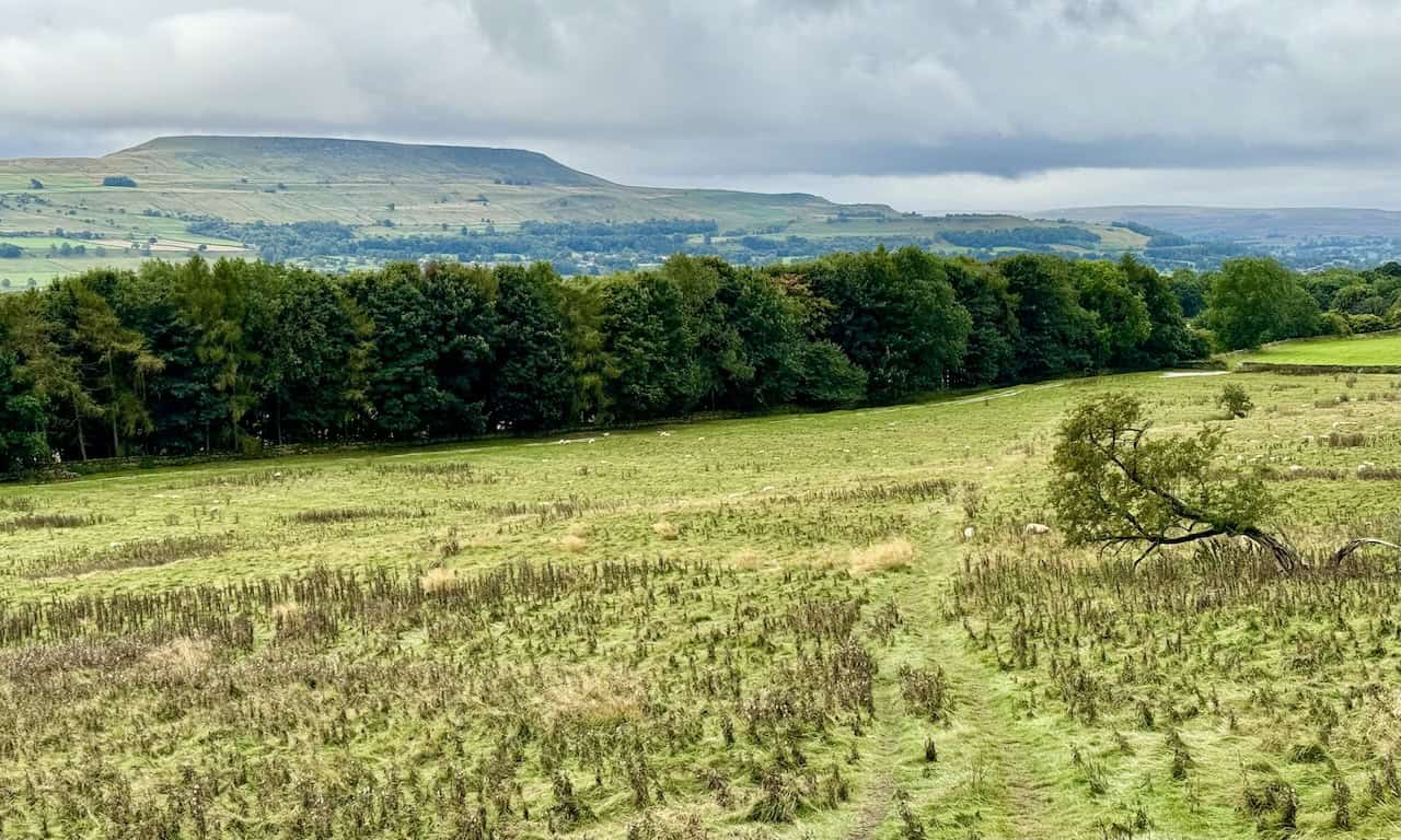
As soon as I step into the field, I’m greeted by stunning views to my left, looking down into the Wensleydale valley. The town cemetery lies below, and beyond that, a vast patchwork of fields stretches across the valley floor. In the distance, Flamstone Pin stands tall on Braithwaite Moor.

A little further along the field, I come across a bench and a topographical stone map overlooking the valley. The map highlights key landmarks visible from this vantage point. I’ve only been walking for about 10 minutes, but I’m already captivated by the beauty of this walk.

Grisport Unisex Adult Peaklander Hiking Boots
AD The Grisport Unisex Adult Peaklander Hiking Boots are crafted in Italy with a durable waxed leather upper, Spotex breathable lining, and a reliable Track-on rubber sole. Waterproof and weighing just 1120g, they offer comfort, resilience, and dependable performance on demanding trails.
After crossing the field and passing the children’s play area on my right, I continue along a lovely path that runs alongside the woods.

The path leads along the edge of the woods, crosses fields, and passes through several gates. Eventually, I reach Leyburn Shawl Plantation. The walk along the Leyburn Shawl terrace is straightforward, easy to follow, and incredibly enjoyable.


Fifty Walks Across the Beautiful North York Moors National Park
AD Discover 50 routes across the North York Moors, from short easy strolls to challenging high-level hikes. With OS maps, route descriptions, and local highlights, it also includes the legendary 40-mile Lyke Wake Walk, described in four accessible stages.
I’m really enjoying this part of the walk. The woodland path is lined with tall, mature trees with twisted branches, creating a beautiful atmosphere. A moss-covered dry stone wall on my right adds to the charm as the path gently weaves through the trees.

At first, the views through the trees to my left are limited to brief glimpses of the valley below and the distant hills. However, I know from previous walks that more expansive views will come soon. Occasionally, I catch sight of the limestone scar that defines the Leyburn Shawl.

Fifty Walks Across the Beautiful North York Moors National Park
AD Discover 50 routes across the North York Moors, from short easy strolls to challenging high-level hikes. With OS maps, route descriptions, and local highlights, it also includes the legendary 40-mile Lyke Wake Walk, described in four accessible stages.
The Woodland Trail remains easy to follow, bordered by tall, twisted trees. The path is comfortable underfoot as it gently meanders across the Leyburn Shawl terrace, making for a pleasant walk.

Eventually, the trees open up to reveal magnificent views of the Wensleydale valley. The limestone outcrop becomes much clearer, adding a dramatic touch to the landscape.


Osprey Hikelite Unisex Backpack for Comfortable and Lightweight Hiking
AD The Osprey Hikelite backpack combines lightweight design with practical features, including a breathable mesh back panel, soft webbing straps, and stretch mesh water bottle pockets. With zipped storage and an organiser compartment, it is ideal for day hikes and outdoor use.
Peeking through the trees, I now have a clear view of Penhill in the distance, dominating the surrounding landscape.
Below me, a patchwork of fields stretches out in various shades of green, divided by hedgerows and dotted with small wooded areas. The views from the Leyburn Shawl are truly stunning.

Osprey Hikelite Unisex Backpack for Comfortable and Lightweight Hiking
AD The Osprey Hikelite backpack combines lightweight design with practical features, including a breathable mesh back panel, soft webbing straps, and stretch mesh water bottle pockets. With zipped storage and an organiser compartment, it is ideal for day hikes and outdoor use.
I reach two stone gateposts where the path splits. The natural choice might be to continue straight on the right-hand fork, but I take the left-hand path, which leads downhill.

Here’s a close-up view of the two stone gateposts. I pass between them and follow the downhill path to the left.


Peak Bagging Wainwrights with Routes to Complete All Fells
AD This comprehensive guide offers 45 circular routes linking all 214 Wainwright fells. With maps, GPX downloads, elevation profiles, and practical advice, it provides efficient yet inspiring ways to complete this classic Lake District challenge at your own pace.
Although many walkers continue straight along the dry stone wall for a bit more of the Leyburn Shawl, I opt to take the left-hand path downhill, heading towards my next destination: Tullis Cote.

The path slopes gently downhill, cutting diagonally across a field towards a line of trees. Penhill remains a striking feature on the horizon.
Peak Bagging Wainwrights with Routes to Complete All Fells
AD This comprehensive guide offers 45 circular routes linking all 214 Wainwright fells. With maps, GPX downloads, elevation profiles, and practical advice, it provides efficient yet inspiring ways to complete this classic Lake District challenge at your own pace.
At the bottom of the hill, the path connects to a wider stone track. I turn right here and continue towards Tullis Cote.

The track eventually splits into two. The right-hand fork heads uphill, but I take the left-hand track, marked as a public footpath, leading through gates and downhill towards the farm and large barns at Tullis Cote. At this point, I’m about a third of the way through my Leyburn Shawl walk.


Berghaus Hillmaster II GTX Men's High Rise Hiking Boots
AD The Berghaus Hillmaster II GTX men’s hiking boots feature a waterproof, breathable GORE-TEX membrane, a memory foam tongue and collar for a personalised fit, and a Vibram sole delivering exceptional grip, stability, and shock protection for confident performance on any terrain.
After passing the barns on my left, I have the option to continue straight ahead, past a barn with arched doors and square windows. Instead, I turn left to visit the Keldheads Lane lead smelt mill near Tullis Cote.

The Keldheads Lane lead smelt mill, located about half a mile east of Preston-under-Scar, dates back to the mid-19th century, though lead mining here began in the 12th century. The remaining structures include the engine house, chimney, stables, stores, and a wheel pit that once powered pumps with a waterwheel. Although it was one of Yorkshire’s richest lead mines, it eventually closed due to flooding in the lower levels.

Berghaus Hillmaster II GTX Men's High Rise Hiking Boots
AD The Berghaus Hillmaster II GTX men’s hiking boots feature a waterproof, breathable GORE-TEX membrane, a memory foam tongue and collar for a personalised fit, and a Vibram sole delivering exceptional grip, stability, and shock protection for confident performance on any terrain.

After visiting the lead smelt mill, I continue along a quiet road lined with lovely old stone houses. My next goal is to reach the village of Preston-under-Scar.


Kendal Mint Co Energy Gel with Citrus and Mint Flavour
AD Kendal Mint Co energy gels deliver 27g of fast-absorbing carbohydrates plus electrolytes and B vitamins for improved performance. Vegan, gluten free, and Informed Sport certified, these caffeine-free gels are refreshing, easy to digest, and ideal for running, cycling, and endurance.
I arrive at the eastern edge of Preston-under-Scar and search for the public footpath that leads off the road to my left.

The footpath is clearly marked, though walking down what looks like someone’s driveway feels a bit like trespassing.

Kendal Mint Co Energy Gel with Citrus and Mint Flavour
AD Kendal Mint Co energy gels deliver 27g of fast-absorbing carbohydrates plus electrolytes and B vitamins for improved performance. Vegan, gluten free, and Informed Sport certified, these caffeine-free gels are refreshing, easy to digest, and ideal for running, cycling, and endurance.
At the bottom of the driveway, I spot a narrow path to the left of the property’s garage and follow it to continue my journey.

The path takes me through a gated gap in the wall and out into open fields. Although I know I’m on a public footpath, I’m relieved to leave what felt like private property behind.


Thermos Stainless King Flask for Travel and Daily Adventures
AD The Thermos Stainless King 470ml flask keeps drinks hot for 18 hours or cold for 24. With durable stainless steel, vacuum insulation, a serving cup, and a leakproof design, it is perfect for commutes, journeys, and outdoor adventures.
The path descends through fields, crosses a railway line, and leads to a road near Stoneham Cottage.

After crossing the fields, a narrow path between tall hedgerows brings me down to the road at Stoneham Cottage. The next track I need to follow is straight ahead.

Thermos Stainless King Flask for Travel and Daily Adventures
AD The Thermos Stainless King 470ml flask keeps drinks hot for 18 hours or cold for 24. With durable stainless steel, vacuum insulation, a serving cup, and a leakproof design, it is perfect for commutes, journeys, and outdoor adventures.
This is Stoneham Cottage, which lies on my left just before I reach the road. I’m now halfway through my Leyburn Shawl walk.

Heading south from Stoneham Cottage, I enjoy a wonderful view of Haremire House in the foreground, with the village of West Wilton in the middle ground and the imposing Penhill in the distance.

Lake District High Level and Fell Walks with Thirty Routes
AD This pocket-sized guide presents 30 routes on the Lake District’s highest fells, including Scafell Pike, Helvellyn, and Blencathra. With OS maps, colour photographs, and practical notes, it offers circular walks from 4–15 miles graded by difficulty.
Continuing along the concrete road, I pass Bolton Hall on my left. This Grade II listed building was originally built in the late 17th century and rebuilt after a fire in 1902. An 18th-century folly tower also stands in the grounds.

After passing Bolton Hall, I reflect on its rich history. The Bolton Estate has belonged to the Scrope family since medieval times, centred around Bolton Castle. Following the death of Emanuel Scrope, 1st Earl of Sunderland and 11th Baron Scrope of Bolton, in 1630, the estate passed to his eldest illegitimate daughter, Mary, who married Charles, Marquess of Winchester.
In 1675, Bolton Hall was built for the Marquess, who later became the 1st Duke of Bolton. Over the centuries, the estate was passed down through the Dukes of Bolton. However, in 1794, with the death of the 6th Duke of Bolton, who had no male heirs, the dukedom became extinct. The estate then passed to his brother’s illegitimate daughter, Jean Browne-Powlett, who married Thomas Orde, a Tory politician. Orde took on the additional surname Powlett and was ennobled as Baron Bolton in 1797. The estate has remained in the family ever since, and in 2023, it was inherited by Thomas Orde-Powlett, the 9th Baron Bolton, following the death of his father, Harry Algar Nigel Orde-Powlett, the 8th Baron. Thomas Orde-Powlett now resides at Bolton Hall.

Lake District High Level and Fell Walks with Thirty Routes
AD This pocket-sized guide presents 30 routes on the Lake District’s highest fells, including Scafell Pike, Helvellyn, and Blencathra. With OS maps, colour photographs, and practical notes, it offers circular walks from 4–15 miles graded by difficulty.
From Bolton Hall, I head east through Middle Lodge and begin a pleasant stroll through Wensley Park.

Exiting Wensley Park, I pass East Lodge, marking that I’m now about three-quarters of the way through my Leyburn Shawl walk.


Super Sparrow Stainless Steel Insulated Water Bottle with Two Lids
AD The Super Sparrow stainless steel water bottle keeps drinks cold for 12 hours or hot for several. With a straw lid, bamboo cap, BPA-free construction, and durable 18/8 steel, it is ideal for sport, travel, work, and outdoor use.
As I walk through Wensley, I pass the historic Holy Trinity Church. This Grade I listed building, now under the care of the Churches Conservation Trust, dates back to the mid-13th century. It was constructed on the foundations of an earlier 8th-century Saxon church, with later additions in the 14th and 15th centuries. The tower was added in 1719. Holy Trinity received support for many centuries from the owners of Bolton Castle, the Scrope family, who contributed to the church’s upkeep. The church’s records list rectors dating back to 1181, beginning with Geoffrey de Well, and continuing until 2001 with Robert Miles. Although no longer used for regular worship, the church still stands as a significant landmark in the area’s history.

Leaving Wensley, I continue east along Low Lane, then take a left turn up a small tarmac road, passing a large white house with beautiful gardens.

Super Sparrow Stainless Steel Insulated Water Bottle with Two Lids
AD The Super Sparrow stainless steel water bottle keeps drinks cold for 12 hours or hot for several. With a straw lid, bamboo cap, BPA-free construction, and durable 18/8 steel, it is ideal for sport, travel, work, and outdoor use.
After following the public footpath through fields, I cross the old railway line, which signals that I’m nearing the end of my walk in Leyburn.

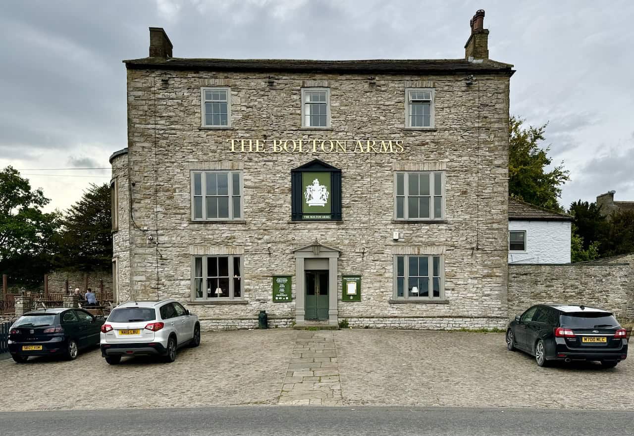
Back in Leyburn, I pass by The Bolton Arms in the town centre before heading to the car park, where I finish my wonderful Leyburn Shawl walk.

Mountain Warehouse Merino Womens Long Sleeve V Neck Top
AD This Mountain Warehouse Merino top combines warmth, comfort, and practicality. Made with high-quality wool, it is naturally antibacterial, lightweight, and easy to pack. Designed for outdoor activities, it keeps you fresh and warm, and comes with a two-year warranty.