ADVERTISEMENT
Enjoy the Best of the Yorkshire Dales Countryside on this Leyburn Shawl Walk
Begin your Leyburn Shawl walk by parking in Leyburn’s Market Place, located in the heart of the town and surrounded by shops. If parking here is unavailable, there is a car park to the rear of the Golden Lion Hotel, which has around 120 spaces. From Market Place, make your way towards the small central bus shelter, where you will find a sign with information about the Leyburn Shawl. Cross the cobbled area, passing the World War I memorial cross on your left and the town hall on your right. Next, cross the main road, High Street, and head straight ahead along Commercial Square.
As you pass Campbells Family Grocers on your right, look for the signpost marked ‘Way to the Shawl’, which directs you down a narrow street. At the end of this street, another sign on the wall guides you left towards the Leyburn Shawl walk and the children’s playing fields. Enter through the gate and follow the flagged path alongside a stone wall. Once through the next gate, you’ll reach Chapel Flats, a large grassy area. Continue walking straight along the path, passing the children’s playing fields on your right and the woodland on your left. The path is then easy to follow as it winds through several fields and gates.
Eventually, the trail leads you into the Leyburn Shawl Plantation. Follow this well-trodden path through the woods for about half a mile (0.8 kilometres). When you reach two tall stone gateposts, the route splits into two paths. While the right-hand path seems more intuitive, take the left-hand path instead. This path descends diagonally across a field to a wider stone track near the trees. Turn right here and follow the track westward for about half a mile (0.8 kilometres) towards Tullis Cote. When the lane splits again, take the left-hand track, descending past several large barns on your left. After passing these barns, continue straight ahead, passing another stone barn with arched doorways and square windows.

ADVERTISEMENT
The track will soon lead you to a minor road. Turn right and follow the road for about one-third of a mile (0.5 kilometres) until you arrive at the village of Preston-under-Scar. Continue straight through the village, and as you reach the western end, the road becomes a narrower stone track. Shortly after, the track splits in two. Between the two, go through the wooden gate and follow the trail into the woodlands of Preston Spring. Continue along the path through the wood for just over half a mile (0.8 kilometres), after which you’ll arrive at a main road. Turn left and carefully walk down this road, as it can be busy, but don’t worry—you won’t be on it for long.
At the next junction, turn right, heading towards Redmire. However, almost immediately turn right again onto a narrow tarmac track, which is signposted as a cycle route. Follow this quiet lane for over three-quarters of a mile (1.2 kilometres) until you reach another main road, Hargill Lane. Cross the road and follow the smaller lane straight ahead, signposted to Castle Bolton. This is a peaceful road that dips into a valley and crosses a bridge over Apedale Beck. The road then ascends back out of the valley, and after half a mile (0.8 kilometres), you will arrive in the village of Castle Bolton.
As you enter Castle Bolton, notice Jacksons Cottage on your right, and further along, Castle View on your left. Pay attention to the lane signposted ‘Public Footpath to Redmire’, as this is where you’ll return after exploring the village. Take the time to explore Bolton Castle, perhaps stopping for refreshments at the castle’s café, visiting the nearby church, or viewing the wild boars near the castle car park. After you’ve explored the area, return to the footpath signposted ‘Public Footpath to Redmire’. This path leads you south-east across fields and countryside for about two-thirds of a mile (1 kilometre) to the village of Redmire.

ADVERTISEMENT
When you reach Redmire, turn right onto Hargill Lane and continue down the road, passing the Bolton Arms until you reach the stone statue on the village green. From here, turn right again and follow the road down to the southern end of the village. As the main road bends to the right, take the smaller lane on your left, Mill Lane. Soon after, turn left again onto Church Lane. After passing a few houses on your right, turn right onto Well Lane. Follow Well Lane for about a quarter of a mile (0.4 kilometres) before leaving it to join a public footpath that crosses farmland.
This public footpath will lead you across several fields in a south-easterly direction to eventually reach West Wood. Walk straight through the woodland, and after about a mile (1.6 kilometres), the path will bring you past Bolton Hall. From here, the route continues through Wensley Park for roughly another mile (1.6 kilometres) until you arrive in the village of Wensley. Upon reaching Wensley, cross the main road (A684) and turn right, then shortly after, turn left onto Low Lane, signposted to Middleham. Pass the church on your right, and after a short distance, take a left onto a smaller road that ascends past a large white house.
As the road bends right and then left, leave the road and follow the public footpath that takes you across open fields. The final stage of your Leyburn Shawl walk takes you through fields, gates, and over stiles for about a mile (1.6 kilometres), guided by public footpath markers. You will eventually cross a railway line and continue across another field to the A684. Turn right and follow this road, which will lead you back into Leyburn.
This 11-mile (18-kilometre) scenic trek offers a perfect mix of Yorkshire Dales countryside and quaint village charm, starting and ending in Leyburn. With its variety of shops and cafés, Leyburn is an ideal base for your Leyburn Shawl walk. Along the way, enjoy spectacular views from the Shawl and explore the beautiful villages of Preston-under-Scar, Castle Bolton, Redmire, and Wensley, all set within the picturesque Wensleydale valley.
Leyburn Shawl Walk: Maps and Tools
Visit either the OS Maps website or the Outdooractive website to view this walking route in greater detail. Both platforms offer a range of features, including the ability to print the route, download it to your device, and export the route as a GPX file. You can also watch a 3D fly-over and share the route on social media. Additionally, this page includes a printable version of the walk in PDF format. Plus there is a supporting video, available for you to watch on YouTube.
Leyburn Shawl Walk: Distance, Duration, Statistics
Distance: 11 miles
Distance: 18 kilometres
Duration: 5 hours
Ascent: 939 feet
Ascent: 286 metres
Type: Circular walk

ADVERTISEMENT
Recommended Ordnance Survey Map
The best map to use on this walk is the Ordnance Survey map of the Yorkshire Dales Northern & Central Area, reference OS Explorer OL30, scale 1:25,000. It clearly displays footpaths, rights of way, open access land and vegetation on the ground, making it ideal for walking, running and hiking. The map can be purchased from Amazon in either a standard, paper version or a weatherproof, laminated version, as shown below.
Standard Version
Yorkshire Dales Walking Guidebooks
Walking in the Yorkshire Dales: North and East, by Dennis Kelsall, describes 43 circular day walks of 3 to 12 miles across the Howgills, Mallerstang, Swaledale, Wensleydale, Coverdale and Nidderdale, with Ordnance Survey mapping and notes on parking and refreshments.
15 Short Walks in the Yorkshire Dales, by Jonathan and Lesley Williams, covers the area around Sedbergh, Kirkby Lonsdale and Ingleton. Its 15 routes of 1 to 7 miles each take under three hours, ideal for families or a relaxed half day out. Both books can be purchased from Amazon, as shown below.
Walking the Yorkshire Dales
About Leyburn
Leyburn is a charming market town and civil parish in North Yorkshire. It sits above the northern bank of the River Ure in Wensleydale. The town’s name originates from the Old English words ‘Ley’ or ‘Le’, meaning ‘clearing’, and ‘burn’, meaning ‘stream’. This gives Leyburn the meaning of ‘clearing by the stream’. According to the 2001 census, Leyburn had a population of 1844, which increased to 2183 in the 2011 census. By 2015, the estimated population stood at 2190.
First mentioned in the Domesday Book of 1086, Leyburn was recorded without a population at the time. Its later rise as a key hub in the area is linked to the decline of nearby Wensley. Wensley had been the main market town in Wensleydale, having received its Royal Charter in 1202. However, following a devastating plague in 1563, Wensley was largely abandoned. By the 17th century, Leyburn gained prominence, and in 1686, Charles II granted the town a market charter. Leyburn’s Town Hall, built in 1856 by Lord Bolton, still stands and now houses several shops.
Related Walk: Similar to the Leyburn Shawl Walk
Experience the beautiful countryside of Wensleydale on the Leyburn Shawl walk
Leyburn is located approximately 19 miles west of Northallerton, the county town, and lies near the eastern boundary of the Yorkshire Dales National Park. Nestled at the edge of Wensleydale, the town is also close to Leyburn Old Glebe, a local nature reserve.
As a gateway to the Yorkshire Dales National Park, Leyburn benefits significantly from tourism. In 2017, the national park attracted 520,000 overnight visitors, contributing to the town’s economy.
To the west of Leyburn, you’ll find Leyburn Shawl, a 2-mile long escarpment offering panoramic views of Wensleydale. It links to footpaths leading towards Preston-under-Scar and Castle Bolton. According to local legend, Mary, Queen of Scots, dropped her shawl here while fleeing captivity at nearby Bolton Castle.
In the market place, you’ll find a Grade II listed war memorial, a cross that commemorates the lives lost in both the First and Second World Wars. Leyburn Hall, another listed building, dates back to 1750 and remains a significant historical feature of the town.
Leyburn Shawl Walk: My Photos
The paved path leads from Commercial Square in Leyburn to the grassy area known as Chapel Flatts. After passing through a gate, I notice a sign to my left that provides information about the Leyburn Shawl. The sign describes the Shawl as a bold limestone terrace extending almost unbroken for two miles (3.2 kilometres). It rises to 870 feet (265 metres) above sea level. The limestone is about 60 feet (18 metres) thick, forming a striking escarpment that overlooks the valley. This rocky scar is mentioned in local history books as the route taken by Mary Queen of Scots during her unsuccessful attempt to escape imprisonment from Bolton Castle. Legend tells that she dropped her shawl during her flight, and this is how the scar got its name.

ADVERTISEMENT
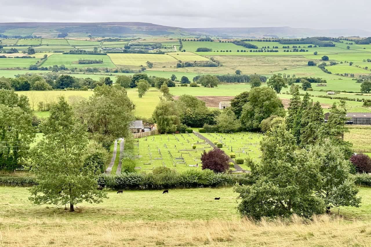
As I walk along Chapel Flatts, I immediately see amazing views to my left, looking down into the Wensleydale valley. Below lies the town cemetery, and beyond it, a patchwork of fields in various shades of green stretches across the valley floor. In the distance, I can clearly see Flamstone Pin on Braithwaite Moor rising against the horizon.
Continuing along the grassy area, I come across a bench and a topographical map that overlooks the valley. The map highlights visible landmarks from this vantage point, including the River Ure, Little Whernside, Penhill, and Addlebrough. Despite having only walked for about 10 minutes, I’m already thoroughly enjoying the experience of the Leyburn Shawl walk.

ADVERTISEMENT
After crossing the field and passing a children’s play area on my right, I follow the path that runs along the edge of the woods, which are on my left.

The easy path leads along the northern edge of the woods, crossing several fields and passing through gates. Eventually, I reach the woodlands of Leyburn Shawl Plantation. This walk along the Leyburn Shawl terrace is simple and easy to follow.

ADVERTISEMENT
I find this section of the walk particularly enjoyable. The woodland path is lined with tall, mature trees, their gnarled branches creating an enchanting atmosphere. To my right, a moss-covered dry stone wall adds to the charm of the Leyburn Shawl walk.

As I continue along the track through the woods, the views to my left are initially limited by the trees. However, I catch occasional glimpses of the valley below and the distant hills. Knowing the area well, I know that the views will open up and become even more impressive as I proceed along the Shawl.

ADVERTISEMENT
The woodland path continues to be easy to follow. The twisted trees border the trail, adding to the magic of the walk. The path is comfortable underfoot as it winds gently through the woodland across the Leyburn Shawl terrace.

Finally, the views open up to reveal the full splendour of the Wensleydale valley. The limestone outcrop I’m walking along becomes more pronounced, and in the distance, Penhill dominates the landscape, providing a dramatic backdrop to this part of Wensleydale.

ADVERTISEMENT
As I walk further, more views appear through the trees, offering glimpses across the valley floor and toward Penhill in the distance. Its towering presence continues to shape the surrounding scenery.

After walking along the Leyburn Shawl for just over a mile (1.6 kilometres), I reach two stone gateposts where the path splits. Although it feels more natural to continue straight along the dry stone wall, today I take the left-hand path, which leads downhill towards my next destination: the track to Tullis Cote.

The grassy path slopes gently downhill, cutting diagonally across the field towards a line of trees. In front of the trees, I can see the stone track where I’ll turn right to continue toward Tullis Cote. Penhill still serves as a magnificent backdrop.

ADVERTISEMENT
Upon reaching the stone track, I turn right and walk toward Tullis Cote. The countryside is peaceful, and the views are just as charming, with green fields stretching out before me.

The track eventually splits again. While the right-hand fork leads uphill, I take the left-hand track, marked as a public footpath, which passes through gates and leads downhill beside some large barns.

After passing the barns on my left, I continue along a stone track. It takes me past a picturesque stone barn with arched doors and square windows.

ADVERTISEMENT
I reach the eastern edge of Preston-under-Scar, where I pause on a bench for a quick snack and a coffee from my flask. Feeling refreshed, I continue walking through the village.

As I walk through the peaceful village of Preston-under-Scar, I’m struck by its charm. This traditional Yorkshire Dales village is tranquil and picturesque, and I imagine it must be a lovely place to live. I am now about a quarter of the way through my Leyburn Shawl walk.

At the western end of the village, the road narrows into a stone track, and I continue forward, following the path as it leaves the village behind.

ADVERTISEMENT
The track soon splits again, but I avoid the left and right forks. Instead, I pass through the gate positioned between them, marked with a yellow public footpath arrow, and enter the woods.

Beside the gate, a silver plaque mounted on a large stone catches my eye. It lists the hills and landmarks visible from this viewpoint, including Penhill, Coverdale, Dodd Hill, and Wether Fell. The view here is simply wonderful.

After enjoying the view and passing through the gate, I enter Preston Spring Wood. The woodland trail here is similar to my earlier walk along the Leyburn Shawl and equally delightful.

ADVERTISEMENT
Continuing west, I walk along a beautiful track beneath Horgra Hill. Looking ahead, I begin to catch sight of Bolton Castle, where I am heading next.

A quiet road leads me down into the valley, where I cross the road bridge over Apedale Beck. The road, called East Lane, takes me uphill again as I continue towards Castle Bolton.

I finally reach the village of Castle Bolton, one of the highlights of the Leyburn Shawl walk. Bolton Castle, a well-preserved 14th-century fortress, stands proudly in the village. It was built by Sir Richard le Scrope, Lord Chancellor of England under Richard II, and is a Grade I listed building. The castle is renowned for its connection to Mary Queen of Scots, who was imprisoned here for six months. According to legend, she dropped her shawl during an escape attempt, hence the name ‘Leyburn Shawl’.


ADVERTISEMENT
Beside Bolton Castle is the charming St Oswald’s Church, a modest stone building with a simple tower. Although a church has stood here since the 12th century, the current structure dates back to the 1320s, making it even older than the castle itself.


A visit to Bolton Castle wouldn’t be complete without stopping to see the wild boars near the castle car park. Over 600 years ago, when the castle was first built, wild boar would have roamed freely in the surrounding woodlands. Wild boar are the ancestors of the domestic pig and the largest of today’s wild hogs. They are native to much of Northern and Central Europe, the Mediterranean, and large parts of Asia. Wild boar became extinct in Britain at the end of the 16th century, but small populations now exist due to escapes from farms and wildlife parks.

Adult males tend to be solitary, especially outside the breeding season, while females and their offspring live in groups called sounders. These groups typically include around 20 animals, but larger sounders of up to 50 have been seen. Each sounder consists of two or three sows, with one being the dominant female. Wild boar are the only hoofed animals known to dig burrows, and they prefer woodland habitats.
Vocalisations are essential for wild boars, as they constantly grunt and communicate with each other. They will scream if alarmed or hungry. Although they are generally timid and will run from humans, wild boar can become extremely aggressive if surprised or cornered, particularly when defending their young.

ADVERTISEMENT
Wild boars are mostly crepuscular, foraging from dusk until dawn but taking resting periods during the night and day. They are omnivorous scavengers, eating a wide range of foods, including grass, nuts, berries, carrion, roots, tubers, insects, and small reptiles. In Australia, they have even been known to prey on young deer and lambs.
Hunting wild boar in medieval Europe was largely a sport for nobles, meant to hone martial skills. Nobles would hunt boar on horseback with dogs, dismounting once the boar was cornered to kill it with a spear or dagger. For extra challenge, they would hunt during the boars’ mating season, when the animals were most aggressive. The boar was considered one of the most dangerous quarry, capable of killing dogs, horses, or men with its ferocious fighting when under attack.

Castle Bolton marks the halfway point of my Leyburn Shawl walk. I take a short break on a bench, enjoying the peaceful surroundings before continuing across the countryside toward Redmire.

Crossing several fields, I arrive at a wooden footbridge over Apedale Beck. Once across the bridge, the path leads directly into the village of Redmire.

In Redmire, a strikingly large, well-shaped tree stands proudly on the village green, next to a stone monument. The monument is set on a raised stone platform, accessible by a few steps, and has a lamp post on top. Three plaques are attached to the monument:
The first plaque reads:
This pillar was erected, and the village streets were supplied with lamps in commemoration of the 50th year of the reign of Her Most Gracious Majesty Queen Victoria, June 20, 1887.
The second plaque reads:
An electric lamp was fitted to the pillar in commemoration of the 25th year of the reign of Her Most Gracious Majesty Queen Elizabeth II, June 7, 1977.
The third plaque reads:
On this site in 2022, we celebrated the Platinum Jubilee of our dear Queen Elizabeth II, who sadly passed away on the 8th of September 2022.

ADVERTISEMENT
After exploring the village of Redmire, I follow Well Lane, which leads me back out into the countryside. I continue my journey south-east across fields toward West Wood.

The route through West Wood is a delight. The woodland path is bordered by tall, mature trees, and sunlight filters through the canopy, casting dappled light on the ground below. It’s a joy to walk through this section on my Leyburn Shawl walk.

Leaving West Wood, I continue east along an easy-going track that takes me past Bolton Hall, which stands to my left. This Grade II listed building was originally built in the late 17th century but was rebuilt after a fire in 1902. An 18th-century folly tower also stands in the grounds. The Bolton Estate has been owned by the Scrope family since medieval times, centred around Bolton Castle. Following the death of Emanuel Scrope, 1st Earl of Sunderland and 11th Baron Scrope of Bolton, in 1630, the estate passed to his eldest illegitimate daughter, Mary, who married Charles, Marquess of Winchester.
In 1675, Bolton Hall was built for the Marquess, who later became the 1st Duke of Bolton. The estate was passed down through the Dukes of Bolton, but in 1794, the 6th Duke of Bolton died without male heirs, and the dukedom became extinct. The estate passed to his brother’s illegitimate daughter, Jean Browne-Powlett, who married Thomas Orde, a Tory politician. Orde took on the additional surname Powlett and was ennobled as Baron Bolton in 1797. The estate has remained in the family ever since, and in 2023, it was inherited by Thomas Orde-Powlett, the 9th Baron Bolton, following the death of his father, Harry Algar Nigel Orde-Powlett, the 8th Baron. Thomas Orde-Powlett now resides at Bolton Hall.

From Bolton Hall, I continue walking along a concrete lane through Middle Lodge, enjoying a peaceful stroll through Wensley Park. By this point, I am just over three-quarters of the way through my Leyburn Shawl walk.

ADVERTISEMENT
At the eastern end of Wensley Park, I pass East Lodge, and the lane leads me into the village of Wensley.

In Wensley, I pass the historic Holy Trinity Church. This Grade I listed building, now under the care of the Churches Conservation Trust, dates back to the mid-13th century. It was constructed on the foundations of an earlier 8th-century Saxon church, with later additions made in the 14th and 15th centuries. The tower was added in 1719. Holy Trinity Church received support for many centuries from the owners of Bolton Castle, the Scrope family, who contributed to its upkeep. The church’s records list rectors dating back to 1181, beginning with Geoffrey de Well and continuing until 2001 with Robert Miles.

Leaving Wensley, I walk east along Low Lane, then take a left turn onto a smaller tarmac road. I ascend past a large white house with beautifully kept gardens on my right.

After following the public footpath from Wensley across the fields, I cross the old railway line, knowing I have nearly reached Leyburn.

Back in Leyburn, I pass by The Bolton Arms in the town centre before returning to the car park. Here, I finish my wonderful Leyburn Shawl walk, having thoroughly enjoyed the journey through this rich landscape, full of history and natural beauty.

ADVERTISEMENT
ADVERTISEMENT