ADVERTISEMENT
Visit Wain Wath Force and Kisdon Force Waterfalls on this Muker Walk
Begin your Muker walk by parking in the village centre, where a designated car park lies just south of Muker and Straw Beck. The entrance is accessed from the B6270 road called Gunning Lane. From the main exit, turn left and cross the road bridge over Straw Beck, then immediately turn left again, heading into the village. Pass a few cottages on your right before walking up the tarmac incline in front of the Muker Literary Institute. Turn right just after the institute and continue uphill into the village centre. At the top, veer left and then right to navigate towards the rear of the central cluster of houses. Here, two public footpaths are available—take the first path signposted to Keld, avoiding the second one, which leads to Gunnerside and Keld via the meadowland, as you will return along that route later.
Follow the tarmac lane between Lane Farm and Stoneleigh, passing the Old Vicarage before continuing upwards along a stone track. As the path ascends, it bends left, then zigzags steeply uphill in a north-west direction. Avoid any side paths, sticking to the main route as it gradually levels out. A bridleway signpost for Keld will appear—continue towards a farmhouse nestled on the hillside. At the farmhouse, ignore the right turn for the Pennine Way to Keld and instead take the left fork, also signposted Pennine Way. Soon after, at another junction, avoid the left turn to Thwaite, instead turning right to follow the bridleway north up a steep grassy incline, signposted once again for Keld.
Continue along the enclosed track, bordered by dry stone walls. As the path bends left and climbs further, you will pass a memorial stone set in the wall dedicated to Neil W. Jones. At roughly 490 metres in elevation, having walked about 1½ miles from Muker, the trail reaches its highest point. Here, follow the grassy path across the summit in a north-west direction before beginning a gentle descent. A signpost for Keld will confirm you are on track. As you descend the hillside, the path gradually curves north, with a communications tower visible on the right. The grassy track soon meets a stony path—continue straight downhill as the descent steepens, leading to an intersection near an old, moss-covered barn. If you reach the road, you’ve gone too far.

ADVERTISEMENT
At the intersection, turn right and follow the public footpath uphill in a north-easterly direction. The undulating route hugs the dry stone wall—stick to it until the path drops steeply. At the lowest point, find a gate in the bottom-left corner of the field and turn left through it. Walk along the field’s edge with the steep-sided valley and River Swale below on your right. Continue along this path until you reach a gap in the wall on your right, where you will join the Pennine Way. Turn left towards Keld, then soon after, take a right turn onto a concrete and brick track descending steeply, signposted Pennine Way and Swale Trail. This track resembles an old tramway route. At the bottom, cross the bridge over the River Swale to reach the waterfalls near East Stonesdale—a landmark you’ll return to later.
After taking in the waterfalls, follow the stone track uphill towards a bench area. At the top, turn left, staying on the Pennine Way. Continue along the stone track as it climbs again, passing through a farmyard. When the bridleway forks, take the left-hand route, avoiding the steep right-hand Pennine Way path. The track continues in a westerly direction, with Keld and the River Swale below on your left. Eventually, the route descends to a bridge crossing a beck, where you will see Currack Force Waterfall on your left. Press on to reach a minor road, which leads downhill across Park Bridge to meet the main road.
At the main road, turn right for a short detour to Wain Wath Force, another impressive waterfall. After enjoying the view, retrace your steps past Currack Force to return to the East Stonesdale waterfalls and the bridge over the River Swale. Cross back over the footbridge and follow the tramway-style path uphill. At the top, turn left, rejoining the Pennine Way signposted to Thwaite and Muker. Soon, a sign for Kisdon Force Waterfall appears, offering an optional detour—a steep, narrow, and often muddy descent. If you choose to visit the falls, take care, then return to the main Muker walk path.

ADVERTISEMENT
Continue on the Pennine Way until the trail forks. Here, take the left-hand path for Muker, rather than the right-hand route to Thwaite. The path undulates through Rukin Wood, a charming stretch of woodland. Emerging into open countryside, you’ll pass an old stone farmhouse perched on the hillside. The descent from here is steady, weaving past several old stone barns and through multiple dry stone wall gaps. Yellow-painted circles on walls and buildings help to confirm the public footpath. The valley widens as you descend towards the banks of the River Swale.
Follow the grassy riverside path southwards, keeping the River Swale to your left. The route soon leads to Ramps Holme Bridge, a distinctive footbridge crossing the river. Instead of crossing, turn right before the bridge, climbing a short flight of stone steps to pass through a gate signposted for Muker. From here, follow the flagged stone path through a series of grassy hay meadows, which eventually lead you back into Muker village, completing your Muker walk.
Muker Walk: Maps and Tools
Visit either the OS Maps website or the Outdooractive website to view this walking route in greater detail. Both platforms offer a range of features, including the ability to print the route, download it to your device, and export the route as a GPX file. You can also watch a 3D fly-over and share the route on social media. Additionally, this page includes a printable version of the walk in PDF format. Plus there is a supporting video, available for you to watch on YouTube.
Muker Walk: Distance, Duration, Statistics
Distance: 8¼ miles
Distance: 13 kilometres
Duration: 4¼ hours
Ascent: 1786 feet
Ascent: 544 metres
Type: Circular walk

ADVERTISEMENT
Recommended Ordnance Survey Map
The best map to use on this walk is the Ordnance Survey map of the Yorkshire Dales Northern & Central Area, reference OS Explorer OL30, scale 1:25,000. It clearly displays footpaths, rights of way, open access land and vegetation on the ground, making it ideal for walking, running and hiking. The map can be purchased from Amazon in either a standard, paper version or a weatherproof, laminated version, as shown below.
Standard Version
Yorkshire Dales Walking Guidebooks
Walking in the Yorkshire Dales: North and East, by Dennis Kelsall, describes 43 circular day walks of 3 to 12 miles across the Howgills, Mallerstang, Swaledale, Wensleydale, Coverdale and Nidderdale, with Ordnance Survey mapping and notes on parking and refreshments.
15 Short Walks in the Yorkshire Dales, by Jonathan and Lesley Williams, covers the area around Sedbergh, Kirkby Lonsdale and Ingleton. Its 15 routes of 1 to 7 miles each take under three hours, ideal for families or a relaxed half day out. Both books can be purchased from Amazon, as shown below.
Walking the Yorkshire Dales
About Muker
Like many settlements in Upper Swaledale, Muker’s name reveals its Viking origins. It derives from the Old Norse term ‘Mjor-aker’, meaning ‘a small piece of farmed land’. However, the area’s history stretches back far beyond the Viking era. Archaeologists have discovered Neolithic flint artefacts, proving that people lived and worked in this landscape thousands of years before the Norse settlers arrived.
In the 18th and 19th centuries, lead mining brought significant prosperity to Muker, as reflected in its fine church and impressive community buildings. Today, the village thrives in a different way—the unspoilt, remote beauty of the surrounding landscape attracts visitors from far and wide, drawn to Swaledale’s rugged charm.
The Buttertubs
The Buttertubs, a group of remarkable limestone potholes, lie beside the road that climbs out of Swaledale towards Wensleydale, not far from Muker. These deep fissures, which reach depths of at least 24 metres, were formed over thousands of years by slightly acidic rainwater dissolving through faults and cracks in the limestone.
Their unusual name originates from a local story—it is said that Swaledale farmers returning from Hawes market would lower their unsold butter into the cool depths of the potholes to preserve it before continuing their journey home.
Muker Meadows
The flower-rich hay meadows surrounding Muker are of international importance and are carefully protected. These ancient wildflower meadows, managed using traditional farming methods, provide a rare glimpse into an almost lost way of life. Farmers receive grants that allow them to continue working the land without using artificial fertilisers, preserving the delicate balance of the ecosystem.
In 1998, the Yorkshire Dales National Park Authority, in collaboration with local farmers and with funding from the Yorkshire Dales Millennium Trust, completed an important conservation project. They laid stone flag paths through the Muker walk meadows, protecting the fragile plant life from trampling while also making the area accessible to wheelchair users.
Related Walk: Similar to the Muker Walk
Visit historic Swaledale mining sites on the Gunnerside Gill walk in Yorkshire
Swaledale Sheep
To survive the harsh climate and poor grazing conditions of the northern Yorkshire Dales, a sheep must be incredibly hardy. The Swaledale sheep, with its coarse wool and natural ability to find grazing in even the most barren landscapes, is perfectly suited to the task.
This breed descends from the Heath sheep, whose wool formed the foundation of a thriving hand-knitting industry. Until well into the 19th century, local farmers and lead miners relied on knitting as a valuable source of additional income. In the 1970s, these traditional skills were revived by Swaledale Woollens, and today, it is once again possible to buy hand-knitted stockings in Muker.
Field Barns and Dry Stone Walls
The field barns and dry stone walls of Swaledale, built between the late 18th and early 19th centuries, remain one of the defining features of this landscape. Both played a crucial role in traditional farming. The walls enclosed grazing land, while the field barns provided shelter for cattle and storage for hay, which was used to feed the animals through the harsh Yorkshire Dales winters.
Each spring, the muck collected inside the barns was spread across the surrounding meadows, fertilising the fields and ensuring a healthy hay crop for the following year. Maintaining these structures is labour-intensive and costly, but with the support of the Yorkshire Dales National Park Authority and English Heritage, local farmers can apply for repair grants to help preserve these iconic elements of the landscape.
St Mary’s Church
A chapel-of-ease was established in Muker in 1580, providing a local place of worship. Before that, the dead had to be carried in wicker baskets along the 12-mile journey to Grinton for burial, following a route known as the Corpse Way.
Over the centuries, St Mary’s Church has undergone significant alterations and restorations, particularly in the 18th and 19th centuries. As a result, little remains of the original 16th-century structure, yet the church continues to hold historical significance within Muker.
Related Walk: Similar to the Muker Walk
Follow the Yockenthwaite walk for a beautiful trek through Langstrothdale
Muker Silver Band
One of the last surviving silver bands in Swaledale and Wensleydale, the Muker Silver Band was formed in 1897 to celebrate Queen Victoria’s Diamond Jubilee.
A dedicated working committee, made up mainly of local farmers, raised the funds needed to buy second-hand instruments and hired a local band leader to provide instruction. Just four months after its founding, the Muker Silver Band gave its first public performance. Today, the band remains an important part of Muker’s cultural and musical heritage.
The Literary Institute
The lead mining boom brought significant wealth to Muker, and the Muker Literary Institute, built in 1867, is a reflection of this prosperity. Funded through public subscription, the institute quickly became a focal point for self-education and intellectual engagement within the village. By the end of the 19th century, its library housed 600 books, providing access to a broad range of knowledge for local residents.
Architecturally, the building is striking—its ornate stone façade has an almost Flemish appearance. However, no records exist to explain why this particular style was chosen for Muker, adding an element of mystery to the institute’s design.
Ivelet Bridge
Situated between Muker and Gunnerside, just off the main road, Ivelet Bridge is considered one of the finest bridges in Swaledale. Its high, single-span arch showcases expert stone masonry and has stood the test of time.
A large, flat stone near the bridge is said to have served as a resting place for coffins carried along the Corpse Way, the ancient route used to transport the dead from Upper Swaledale to Grinton Church, beyond Reeth.
Final Thoughts on Muker’s Heritage
Muker is a village with a rich and diverse history, shaped by Viking settlers, lead miners, traditional farmers, and musicians alike. Its unspoilt landscape, historic buildings, and cultural traditions continue to make it one of the most fascinating places in the Yorkshire Dales. Whether it’s the legend of the Buttertubs, the wildflower-filled hay meadows, or the centuries-old dry stone walls and barns, Muker is a place where the past and present exist side by side.
For visitors exploring Swaledale, Muker is not just a destination—it’s an experience, offering a glimpse into a way of life that has endured for generations.
Muker Walk: My Photos
After leaving the car park, I begin my Muker walk by crossing the bridge over Straw Beck and making my way into the village. The weather forecast is promising, with no rain expected, and I have a strong feeling that this is going to be a fantastic walk.

ADVERTISEMENT
Passing the first few cottages, I head up the bank in front of the Muker Literary Institute. Then, I take an immediate right turn.

Muker Literary Institute
This distinctive building, constructed in the 1860s, was originally a reading room for local people (primarily men). Its decorative gable end gives it an almost Flemish appearance, but little is known about the architect or the reason for this stylistic choice. Reading rooms were established in many villages throughout the Yorkshire Dales to provide young men with an educational and wholesome place to spend their time.
The institute was built through public subscription for approximately £260, with specifications that it be ‘two storeys high of a neat and substantial character with freestone dressings.’ Education was highly valued by working people, and the institute housed over 600 books in specially built bookcases upstairs, offering a broad range of literature alongside a daily newspaper and periodicals that brought the wider world to this remote community.
Over time, the building’s function evolved, though it remained a key part of village life. From the 1920s to the present day, Muker Silver Band has used the building, currently rehearsing in the upper room. The ground floor is now utilised for meetings and exhibitions, ensuring that the institute continues to serve as a valuable community hub.

ADVERTISEMENT
Muker Public Hall
Before leaving the village, I make a quick detour to visit Muker Public Hall and St Mary’s Church. Muker Public Hall, located in Upper Swaledale, North Yorkshire, is a vital community facility that has played an important role in village life for many years. It was originally built in 1922 and underwent a major refurbishment in 1997. Development remains ongoing to ensure it continues to meet the needs of the community. As of 21 March 2024, the hall will be officially registered as a Charitable Incorporated Organisation (CIO). It is managed by Muker Public Hall and Literary Institute CIO and governed by a team of eight trustees, with Chris Stanley serving as Chair.
The hall is well-equipped with a stage, tables, chairs, crockery, cutlery, and a fully equipped kitchen, making it a versatile space for a variety of events and gatherings. It serves multiple roles within the community, providing a venue for meetings, lectures, classes, and exhibitions, while also offering space for recreation and leisure activities. The hall’s primary aim is to enhance the quality of life for the inhabitants of the Parish of Muker, ensuring that this rural community has a welcoming and well-maintained space for social and cultural events.

St Mary’s Church, Muker
St Mary’s Church is one of four churches in the ecclesiastical Parish of Swaledale with Arkengarthdale. It was built in 1580, replacing an earlier chapel-of-ease that was subordinate to St Andrew’s Church in Grinton. Before the consecration of St Mary’s, all baptisms, weddings, and funerals had to be conducted at Grinton.
The Church of St Mary the Virgin is notable for being a rare example of an Elizabethan-era house of worship. Few churches were constructed during this period, making it historically significant. Originally, the roof was thatched, but it was replaced with slate in 1791. The tower is thought to have been shorter at first, later adapted in 1719.
Sir Stephen Richard Glynne, 9th Baronet (1807–1874), a Welsh landowner and Conservative politician, once described the tower as ‘wholly devoid of character’ and the windows as ‘perpendicular’, while deeming the entire structure ‘mean and ugly’. Despite this harsh critique, St Mary’s Church remains an important part of Muker’s history.

ADVERTISEMENT
Only a few minutes after leaving the village, I reach a breathtaking viewpoint. Sheep graze peacefully in the foreground, a lovely old stone barn stands in the middle ground, and behind it, the steep slopes of Ivelet Side rise to Beale Hill, creating a stunning scene.

As I leave the village behind, I begin my ascent towards Kisdon. Looking back at Muker, the sunlight breaks through the clouds, illuminating Swaledale beautifully. The patchwork of green fields surrounding the village is spectacular, framed by the slopes of Muker Side and Oxnop Side. The view is already incredible, and I haven’t even climbed that high yet!
ADVERTISEMENT
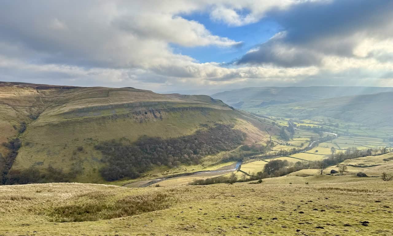
Continuing my Muker walk, I follow the zigzagging track uphill towards Kisdon. I can’t stop glancing back at the breathtaking view of Swaledale below. From this height, I can see the River Swale winding its way through the valley floor, with Blea Barf on Crackpot Moor forming the backdrop. The landscape is absolutely stunning.

As I continue uphill, I am rewarded with a spectacular view westward towards the peaks of Hood Rigg, Little Shunner Fell, and Great Shunner Fell. Sunlight pierces through the clouds, casting bright patches on the hillsides. On Great Shunner Fell, which is the most distant of the three peaks, small patches of snow still cling to the slopes.

ADVERTISEMENT
This part of the Yorkshire Dales is simply amazing. The scenery is quintessentially Yorkshire, with traditional farmhouses, stone barns, and dry stone walls lining the hillside. Great Shunner Fell stands proudly in the background, its lingering snow now easier to see. Swaledale is undoubtedly one of my favourite areas in the Yorkshire Dales.

After the initial steep climb out of Muker, the track levels out slightly as I approach a farm. However, I know this flatter section won’t last long—another steep incline lies ahead before I reach the top of Kisdon.

As I continue my ascent, I gain a more elevated perspective of Swaledale. The River Swale is now clearly visible, meandering along the valley floor. Sunlight filters through the clouds, casting a golden glow over the landscape. On the steep slopes of Ivelet Side, I can see Ivelet Wood, while the rugged outcrops of Ivelet Broads stand prominently on the south-west slopes of Beale Hill.
ADVERTISEMENT
I reach the highest point of this section of my Muker walk, at approximately 490 metres. A magnificent grassy path stretches before me across the hilltop. Although the hill is called Kisdon, I am not heading to its 499-metre summit. Instead, I follow a route that skirts the southern and western sides of the hill before descending towards Keld. The interplay of sunlight and shadows on the hills creates a mesmerising effect—some areas are brilliantly illuminated, while others remain in deep shade. This is a wonderfully comfortable and enjoyable stretch of the walk. What a treat!

The track gently descends the south-western slopes of Kisdon, and the landscape is simply delightful. The beauty of this countryside is overwhelming, and I am thoroughly enjoying every moment of my Muker walk.

As I descend further, I am rewarded with a breathtaking view of three high fells on the horizon—Lovely Seat, Hood Rigg, and Little Shunner Fell from left to right. On the far right, a small sliver of snow remains on the slopes of Great Shunner Fell. I can just about make out the sunlit road winding through the valley—the route connecting Thwaite and Keld.

ADVERTISEMENT
Continuing northwards and gradually descending the western slopes of Kisdon, I pass a farm and a communications tower nestled into the hillside on my right-hand side.

Looking left, or westward, as I descend, I spot the hamlets of Angram and Aygill across the valley. Below them, Skeb Skeugh, a stream flowing from north to south, meanders along the valley floor.

The track down Kisdon becomes steeper and eventually meets a public footpath just before reaching the road leading into Keld. In the distance, I can see the road, while on my left, just over a wall, a moss-covered barn with a slate roof marks the location of this intersection.
ADVERTISEMENT
Continuing my Muker walk, I now follow the public footpath along the northern slopes of Kisdon. The sunlight casts a golden glow over the landscape, enhancing the vivid green farmland divided by traditional dry stone walls, so typical of the Yorkshire Dales. Ahead, I can see the road leading into Keld, and beyond the farm buildings, the rooftops of the houses in the village come into view.

My path continues along the northern slopes of Kisdon, closely following a dry stone wall. This entire section of the walk offers continuous, uninterrupted views of the beautiful landscape surrounding Keld in Swaledale. The path is undulating and a little tiring, but the stunning scenery makes every step worthwhile.

As I follow the path towards Keld, I can hear the River Swale rushing through the valley, even though it remains hidden from view. Across the valley, I spot the exposed limestone cliff face that lies just above Kisdon Force, which I plan to visit later in my Muker walk.

ADVERTISEMENT
I follow a cobbled dual track leading downhill towards the River Swale. The cobbles appear to be designed for accommodating the wheels of carts or vehicles in the past, adding a historical touch to the route.

At the bottom of the cobbled track, I reach a footbridge and use it to cross over the River Swale.

Standing on the footbridge, I pause for a moment to take in my surroundings. Looking both upstream and downstream, I admire the River Swale as it flows south-east, carving its way through the valley. This is a lovely, peaceful spot to appreciate the beauty of the Yorkshire Dales.

On the other side of the bridge, I arrive at a beautiful set of waterfalls near East Stonesdale. These falls are often mistaken for Kisdon Force or Catrake Force, but they are neither. The cascade is formed by East Gill, and on some maps, it is simply marked as ‘Falls’. However, some sources refer to it as East Gill Force. Regardless of the name, the sight and sound of the water tumbling over the rocks are mesmerising.

ADVERTISEMENT
I follow the track uphill alongside the waterfalls and reach a grassy clearing with two benches. This seems like the perfect place to stop for lunch, allowing me to relax and soak in the magnificent surroundings.

Leaving the waterfalls behind, I continue west along the track, with the village of Keld now clearly visible on the south side of the valley. The River Swale runs through the valley, separating me from the village.

The track leads me along the hillside on the northern side of the River Swale, guiding me towards my next stop—Currack Force.

I reach a bridge, and just to my left, I see Currack Force, a waterfall created by Stonesdale Beck as it flows from north to south, eventually joining the River Swale. However, the waterfall isn’t fully visible from the bridge, so I briefly leave the track and head down a grassy bank to get a clearer view.

ADVERTISEMENT
After visiting Currack Force, I follow a minor road that descends towards Park Bridge. Standing on the bridge, I pause to take in a wonderful upstream view of the River Swale.

At the bottom of the minor road, I briefly follow the B6270 before turning off to visit Wain Wath Force, one of the highlights of my Muker walk. The path to the falls is through a gate on the right-hand side of the road.

Wain Wath Force, located on the River Swale, features a modest drop of approximately 1.5 metres, with water tumbling gracefully over a broad, rocky ledge into a shallow pool below. Many waterfalls in the north of England have names ending in ‘Force’, derived from the Old Norse word ‘foss’, meaning ‘waterfall’. The name Wain Wath Force likely originates from the old ford that once existed above the falls—‘wath’ being the Anglo-Saxon word for a ford. ‘Wain’ may indicate that it was once passable for a cart or wain. The river flows beneath the limestone cliffs of Cotterby Scar, making the location especially picturesque. It is a popular spot for visitors and wild swimmers alike.

After spending time at Wain Wath Force, I begin retracing my steps. As I walk back along the B6270, I rejoin the minor road that leads over Park Bridge. Along the way, I notice covered yurts, which stand out against the surrounding landscape.

ADVERTISEMENT
My path leads me back towards Currack Force, and even though I have been on this track before, walking in the opposite direction offers an entirely new perspective and fresh views.

I return to the East Gill Falls near East Stonesdale. Noticing that the two benches above the falls are now empty, I take the opportunity to stop for a coffee and enjoy this beautiful location once more.

The route down to Kisdon Force is narrow, stony, and slightly muddy. It is best tackled in dry weather, as the steep path can become slippery when wet. This section is an out-and-back detour—descending into the valley to see the waterfall and then returning along the same route.

Care is needed on the descent, but the path is incredibly interesting. I pass an amazing rock feature—a prominent vertical slab that has fractured away from the main cliff. This is likely the result of freeze-thaw weathering, where water seeps into cracks, freezes, and expands, eventually causing the rock to break apart.

ADVERTISEMENT
Further down, I can clearly see Beldi Hill on the opposite side of the River Swale, its vertical limestone cliff face overlooking Kisdon Force.

Halfway down the path, I reach a level grassy area, where I catch my first proper glimpse of Kisdon Force. This is the smaller of the two drops. The next section of the descent to view the larger waterfall is a little tricky—especially in wet weather. A rope has been installed along this part of the trail to provide support, making the descent slightly more manageable.

Muker Walk: Kisdon Force
Following the steep and tricky path down to the bottom is absolutely worth the effort. From here, I can see Kisdon Force in its entirety. It is one of several waterfalls in the Keld area of the River Swale—the others being East Gill Force, Catrake Force, and Wain Wath Force. All of these waterfalls occur where the River Swale cuts through the Carboniferous limestone gorge between Kisdon and Rogan’s Seat.
The term ‘Force’ comes from the Old Norse word ‘fors’ or ‘foss’, meaning ‘waterfall’. Both the upper and lower drops of Kisdon Force are occasionally attempted by experienced canoeists, though they require a high level of skill. The falls drop 10 metres (33 feet) in total, over two cascades, and are surrounded by Kisdon Force Woods, a Site of Special Scientific Interest (SSSI) covering 38 hectares.
After my visit to Kisdon Force, I climb back up the narrow path to rejoin the main route and continue my Muker walk. The trail now winds through Rukin Wood, an enchanting stretch of ancient woodland. The old dry stone walls, heavily overgrown with moss and vegetation, give the area an almost mystical feel. The trees lean over the path, their twisted branches draped in thick, green moss, creating an atmospheric and almost timeless scene.

Emerging from Rukin Wood, I step into open countryside. The track gradually descends, passing an abandoned farmhouse on my right. I pause for a moment, wondering how old this building is, who might have lived here, and what life must have been like in such a remote setting.

ADVERTISEMENT
As I continue my descent, the River Swale reappears in the valley below. The slopes of Black Hill, bathed in sunlight, create a stunning backdrop on the eastern side of the river. The contrasting vegetation on the hillsides makes the landscape appear vibrant and colourful, adding to the beauty of this section of my Muker walk.

Eventually, I reach the valley floor, where the landscape opens up, giving a sense of space and tranquillity. Now at river level, I follow a grassy path through fields dotted with old stone barns. This is one of the most enjoyable sections of the Muker walk, offering a perfect blend of history, nature, and traditional Yorkshire Dales scenery.

Muker Walk: The River Swale
I finally reach the banks of the River Swale. This river is one of the major tributaries of the River Ure, which eventually becomes the River Ouse before flowing into the North Sea via the Humber Estuary.
The River Swale gives its name to Swaledale, the valley through which it flows. Like many rivers in this region, it has played a crucial role in shaping human settlements over the centuries. It has provided water for agriculture, livestock, and even historic mining activities dating back to Roman times and beyond. The River Swale is known for its fast-flowing waters—in fact, it is often said to be the fastest flowing river in England. Its levels can rise dramatically, by as much as 3 metres (10 feet) in just 20 minutes. The river’s source lies at the confluence of Birkdale Beck and Great Sleddale Beck, at the bottom of the valley known as Birk Dale, approximately 2½ miles west of Keld.

Following the footpath alongside the River Swale, I eventually approach a footbridge known as Ramps Holme Bridge. It’s a beautifully constructed bridge, standing gracefully over the river. However, on this occasion, I do not cross it. Instead, just before reaching the bridge, I turn right and pass through a gate in the dry stone wall, entering the iconic Muker meadowland.

Muker Hay Meadows
The traditional hay meadows north of Muker—designated as a Site of Special Scientific Interest (SSSI)—are some of the finest examples in the Yorkshire Dales. Such meadows were once a common sight across the region, playing a crucial role in traditional farming.
After being mown and dried in the sun, the grass and wildflowers became sweet-smelling hay, stored inside stone cowhouses to feed livestock through the harsh winter months. The only fertiliser used on these fields is still the natural muck produced by cattle kept in nearby cowhouses.
This is one of the last areas in Swaledale where cattle are still housed in the traditional way, although they are no longer tied in stalls as they once were. Out of respect for this delicate ecosystem, I stick to the stone-flagged path, as requested by the signs, ensuring that I do not trample the grass or damage the farmer’s crop. The path leads me gently back towards Muker village.

ADVERTISEMENT
Muker Cowhouses
Looking back at where I have been, I am treated to magnificent views of the fields and stone barns that define this landscape. The Parish of Muker is home to hundreds of small field barns, known locally as cowhouses.
These structures formed part of a unique farming system, thought to have originated in the seventeenth century and continuing into living memory. Milk from dairy cows provided a valuable income for local farmers, particularly when turned into cheese and butter.
Winters in Upper Swaledale can be harsh, so cattle were traditionally brought inside around November and housed in these small cowhouses. They were fed on hay stored inside the barn, cut from the surrounding fields in summer. In spring, the cows were released to graze on the hillside pastures, and the accumulated muck from the cowhouses was spread onto the meadows, fertilising the next season’s hay crop.
This Muker walk has been an incredible journey through the Yorkshire Dales, filled with breathtaking landscapes, historic landmarks, and fascinating insights into the area’s rich agricultural heritage. From Muker village to the waterfalls of Keld, the stunning hay meadows, and the timeless dry stone walls, every step has been a reminder of why this part of the Yorkshire Dales is so special.
As I return to Muker, I take one last look back at the fields, barns, and hills. This has been a truly memorable walk, and I already know that I will be returning to this beautiful part of Swaledale again in the future.

ADVERTISEMENT