ADVERTISEMENT
Explore Lead Mining Heritage and Wath Mill on the Pateley Bridge Walk
Begin your Pateley Bridge walk by parking in the Nidderdale Agricultural Society car park. This spacious car park sits beside the road bridge over the River Nidd, directly opposite the Bewerley Recreation Play Area. Public toilets are available next to the recreation area.
From the car park, turn left and walk along the road as though heading towards Grassington. Pass Low Wath Road on your right, then continue past the filling station and shop, also on your right-hand side. Immediately after the shop, take the public footpath on your right.
Follow this footpath uphill until you reach a road. Turn right, then almost straightaway turn left onto another footpath, signposted to Ladies’ Riggs. Continue walking west along this path, following the waymarkers for the Industrial Heritage Trail, for just over half a mile.
When you reach a minor road, turn right. You are now on the Nidderdale Way, which is also a public bridleway and continues to follow the Industrial Heritage Trail. Keep walking west along this minor road for roughly a mile.
Eventually, you will pass Low Waite Farm on your right-hand side. Shortly afterwards, the road splits. Take the right-hand road, signposted to Ashfold Side and Cock Hill. The road bends sharply to the right as it reaches Hillend, where it becomes a wide, stony track. You remain on the Nidderdale Way.
From Hillend, continue west for just over a third of a mile to reach Brandstone Dub Bridge. Cross the bridge and carry on walking as the track bends left and climbs uphill. Blue public bridleway markers guide your way, and you’re still on the Nidderdale Way.

ADVERTISEMENT
After another third of a mile, you’ll reach the Prosperous and Providence Lead Mines information board. Take the public footpath downhill to your right and cross the footbridge over Ashfold Side Beck. On the far side, turn right and follow the Nidderdale Way bridleway up the valley side until you reach a stone track. Turn right and head east along this wide track.
As you walk, Ashfold Side Beck remains in the valley on your right-hand side. Continue along this route for about one and a quarter miles. The track gradually changes into a tarmac minor road as you pass a series of caravan parks on either side.
Stay alert for the point where the Nidderdale Way branches left from the tarmac road. This turning is located at a concrete bridge with metal parapets and a metal gate crossing the beck on your right. A blue public bridleway marker indicates the way.
Follow the bridleway up the grassy bank between two farmhouses. Continue north along this clearly marked path, guided by blue waymarkers, for over half a mile until you reach the hamlet of Heathfield.
After walking through Heathfield, turn right onto Grange Lane, a minor road. Pass a small corrugated iron church on your left, then shortly afterwards, turn left onto a stone track leading down to Spring Hill Farm. When you reach the farm, take the public footpath on your right.
Follow the yellow waymarkers downhill across a steep grassy slope for nearly half a mile. You’ll arrive at a road and Wath Bridge. Cross the bridge as though entering Wath, then immediately turn left onto the public footpath signposted Six Dales Trail.

ADVERTISEMENT
This riverside section of the Pateley Bridge walk follows the River Nidd for about half a mile to the northern end of the reservoir dam. Continue slightly uphill to a T-junction, then turn right onto the public bridleway signposted to Wath.
Follow this bridleway for approximately three-quarters of a mile. Along the way, you’ll cross a viaduct and pass some abandoned farm buildings. The path then descends through woodland to reach a minor road.
Turn right and walk past Wath Mill and The Sportsman’s Arms, both on your right-hand side, as you return to Wath Bridge. Just before the bridge, turn left at the yellow public footpath marker.
Keep following this footpath across several fields for around three-quarters of a mile. The River Nidd remains on your right, though initially some distance away. Eventually, the path brings you closer to the riverbank.
Continue along this scenic riverside section for another half a mile or so. You’ll reach a large steel footbridge on your right, which crosses the River Nidd. Cross the bridge, turn left, and walk along the river path.
You’ll pass a large caravan park on your right, followed by some playing fields. Walk alongside the Bewerley Recreation Play Area to return to the car park where your Pateley Bridge walk began.
Pateley Bridge Walk: Maps and Tools
Visit either the OS Maps website or the Outdooractive website to view this walking route in greater detail. Both platforms offer a range of features, including the ability to print the route, download it to your device, and export the route as a GPX file. You can also watch a 3D fly-over and share the route on social media. Additionally, this page includes a printable version of the walk in PDF format. Plus there is a supporting video, available for you to watch on YouTube.
Pateley Bridge Walk: Distance, Duration, Statistics
Distance: 8½ miles
Distance: 14 kilometres
Duration: 4¼ hours
Ascent: 1303 feet
Ascent: 397 metres
Type: Circular walk

ADVERTISEMENT
Recommended Ordnance Survey Map
The best map to use on this walk is the Ordnance Survey map of Nidderdale, reference OS Explorer 298, scale 1:25,000. It clearly displays footpaths, rights of way, open access land and vegetation on the ground, making it ideal for walking, running and hiking. The map can be purchased from Amazon in either a standard, paper version or a weatherproof, laminated version, as shown below.
Weatherproof Version
Ordnance Survey map of Nidderdale, reference OS Explorer 298, scale 1:25,000
About Pateley Bridge
Pateley Bridge sits at the entrance to Nidderdale, a valley officially recognised as an Area of Outstanding Natural Beauty since 1994. Nestled within the Nidderdale National Landscape, the town earned praise in The Sunday Times lists of the Best Places to Live in northern England in both 2017 and 2018.
Its charming high street stretches through the centre of town, lined with inviting tea rooms and an excellent variety of independently run shops. Among these are two celebrated butchers, a selection of art and antique dealers, and the town’s most famous attraction: the world’s oldest sweet shop. Established in 1827 and housed in a building that dates back to 1661, it remains a beloved part of Pateley Bridge’s heritage.
Running parallel to the high street is King Street. At the top, in a former workhouse, the Nidderdale Museum tells the story of the area’s social and industrial past through an impressive collection of local artefacts. Just nearby, the King Street Workshops host a group of skilled artists and craftspeople who continue the town’s creative traditions.
As the main settlement in Upper Nidderdale, Pateley Bridge has experienced centuries of change. Archaeological discoveries suggest Neolithic communities once inhabited the area. The River Nidd, whose name derives from a Celtic word meaning ‘sparkling’, was a natural focal point. However, it wasn’t until the Anglo-Saxon period that permanent settlements emerged, often as scattered hilltop farms built near natural springs. Before the Norman Conquest, the land came under the ownership of the Archbishop of York. His manor extended from Wath to Wilsill and became known as Bishopside, a name that still defines the local parish today.
In the early 14th century, after a series of failed harvests and raids from the Scots, the Archbishop secured permission to establish a market and fair in Pateley Bridge to encourage local trade. A weekly market was held every Tuesday (though it no longer runs), while an annual fair took place on 8th September to mark the Feast of the Nativity of the Blessed Virgin Mary. Today, the fair continues, albeit a little later in the month, as part of the Nidderdale Show. Held at the Bewerley Park Showground, it combines a major agricultural event with a visiting funfair.
As the population increased, the land could no longer support everyone through farming alone. Many locals turned to mining and quarrying for work, particularly around Greenhow Hill. Lead had been extracted in the area since Roman times, and in 1363, lead from Nidderdale was used to roof Windsor Castle. At St George’s Chapel in Windsor, steps were made from Nidderdale marble, a crinoidal limestone quarried at Blayshaw near Lofthouse. This same stone featured in the construction of Fountains Abbey.
Traditional handloom weaving, once common in the Dales, gradually gave way to linen production. Although some flax was grown locally, much of it arrived via Hull and Boroughbridge from mainland Europe.
The town’s growth in the 19th century owed much to the Metcalfe family, who invested heavily in mills, breweries, and stone quarries. George Metcalfe played a key role in bringing the railway to Nidderdale. He owned a majority share in the Scot Gate Ash Quarry and constructed an inclined railway to move stone efficiently from the hillside down to the railway sidings. This allowed quick dispatch of stone to major building projects nationwide. Scot Gate Ash, a fine-grained Millstone Grit, was used in prominent public buildings, including Victoria Station, the National Gallery, and several museums in London. By the 1880s, it was the largest quarry in the West Riding.
During the 19th century, Pateley Bridge became a thriving industrial town with a lively cultural scene centred around its churches and chapels. But by the end of the century, the lead mines were in steep decline. Many quarries followed suit just a few decades later. By the 1960s, the remaining flax and linen mills—by then producing string and rope—had also shut down. This marked a period of economic downturn for the town.
However, the tide began to turn. The rise of tourism and the clearing of derelict buildings sparked a gradual revival. That process of regeneration continues today, helping Pateley Bridge remain a vibrant and welcoming gateway to the Nidderdale landscape.
Pateley Bridge Walk: My Photos
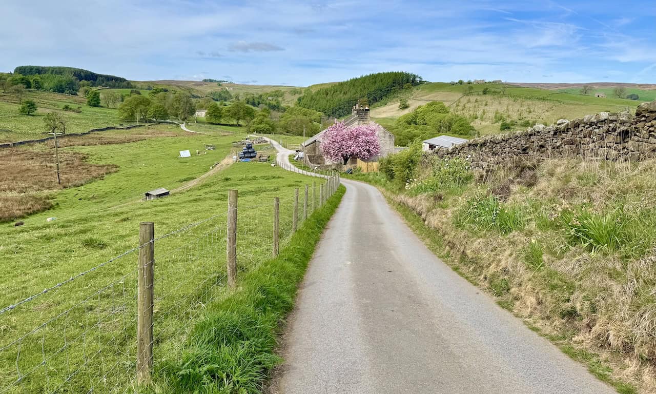
After leaving Pateley Bridge and joining the Nidderdale Way, I head west along a quiet country lane. The surrounding countryside is absolutely stunning, typical of the Nidderdale Area of Outstanding Natural Beauty (AONB). As I walk, the landscape opens up into a patchwork of green fields and gently rising hills, offering a peaceful start to this Pateley Bridge walk.
ADVERTISEMENT
The route leads me past several farmhouses, each one quietly nestled into the landscape and full of character. I pass Low Waite Farm, where a neatly carved sign is set into the dry-stone wall at the entrance. The farmhouse is built from pale stone and topped with dark slate tiles. Wooden benches sit outside in the sun, adding a homely touch to the scene.

At Hillend, I come to another farmhouse, this one more hidden and secluded. Its stone walls are softened by trailing ivy and climbing plants. Surrounded by moss-covered walls and dappled shade from nearby trees, it feels tucked away and tranquil.

ADVERTISEMENT
I arrive at Brandstone Dub Bridge, a charming little crossing on the Nidderdale Way. This single-arched stone bridge spans Brandstone Beck and is built from local stone. It blends so naturally into the scenery that it feels like it’s always been part of the landscape.
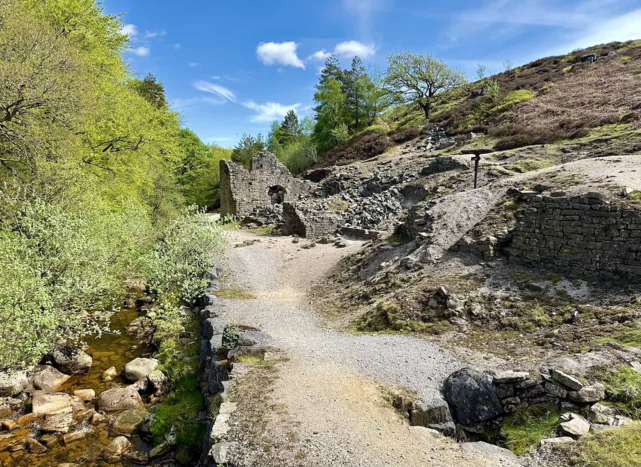
As I continue along the Nidderdale Way, I begin to climb gently, and the views start to open up in every direction. The colourful fields of Nidderdale stretch out beneath a bright sky. In one of the fields, I spot a cluster of stone buildings, which I recognise as part of Providence House. I’ve reached the site of the Prosperous and Providence Lead Mines, a fascinating stop on this Pateley Bridge walk.

ADVERTISEMENT
Pateley Bridge Walk: The Prosperous and Providence Lead Mines
Over two centuries ago, miners toiled deep underground in the hope of profit, extracting lead from rich mineral veins beneath the landscape. The Prosperous and Providence Lead Mines were among several lead mining sites once active in the Greenhow area. While today’s landscape shows little more than abandoned spoil heaps and ruined buildings, the surviving remains are only the visible portion of a much larger story. Beneath the surface lies a hidden world of tunnels and vast underground waterwheels.
Geology and Early Prospecting
Galena, the primary ore of lead, occurs naturally in this area. Around 300 million years ago, during the Carboniferous period, layers of gritstone and shale were laid down as sediments. Mineral-rich fluids later seeped into cracks and faults between these layers, forming ores such as galena.
Early mineral prospecting in Nidderdale may have relied on local shepherds, who spotted veins of shiny galena along exposed rocks or glinting in streambeds. The Romans are believed to have mined lead in the area, and by the 1100s, Norman barons had granted mining rights to the monks of Byland and Fountains Abbeys.

Why Mine Here?
The Prosperous and Providence mines mainly worked the ‘Black Vein’, thought to be part of the larger Bycliffe Vein on Grassington Moor. This particular vein proved to be productive over many years. Lead was a valuable and versatile metal, used for roofing, piping, and later in the manufacture of ammunition such as bullets and cannonballs.
In the early days, miners faced constant problems with underground flooding. Without advanced drainage, they could only dig below the waterline during droughts. This changed by the mid-nineteenth century, when a steam engine at Providence Shaft and several underground and surface waterwheels, including one at nearby Wood’s Shaft, provided the power to drain the workings more effectively.

ADVERTISEMENT
Remains and Features of the Prosperous Mine
A number of important archaeological features survive at the site of the Prosperous Lead Mine:
- Spoil Tips: Much of the evidence of early mining may lie beneath these spoil heaps. Finer material on top was deposited between 1887 and 1889, when earlier tips were reprocessed to recover barytes, a mineral once discarded as waste.
- Dressing Mill: Here, metal ores were crushed and separated from waste rock.
- Smelt Mill: Built by John Lupton between 1800 and 1815, the smelt mill processed the lead ore into usable metal.
- Flues, Beehive Condenser and Chimneys: Poisonous fumes from smelting were channelled away from the mill through a network of flues. Children were employed to clean the walls and floors of these flues and the condenser, recovering lead dust from condensed toxic vapours.
- Providence Engine House: In years of drought, when waterwheels could not operate, the burden fell to the old steam engine. This engine, under increasing strain, finally broke down in 1843.
- Smelt Mill Shaft: First equipped with underground waterwheels in 1818, this shaft was crucial for pumping water out of the mines.
- Prosperous Shaft: First mentioned in records from 1781, although it was likely sunk earlier. In 2016, the shaft was capped with a metal grill as part of site consolidation and safety works.

Pateley Bridge Walk: Prosperous Smelt Mill
On the site lie the remains of Prosperous Smelt Mill, once a noisy, smoky, and bustling industrial site. For over a century, this mill processed lead ore extracted from the mineral veins that run beneath the surrounding hills. Ore was smelted here to extract lead, which was then cast into ingots and sold for profit. By 1904, the mine was described as being in ruins, marking the end of a long and labour-intensive chapter in Nidderdale’s industrial past.
How the Smelt Mill Worked
The smelting process involved several distinct stages:
- Wash: Raw ore was first washed using water drawn from the nearby gill.
- Crush: The clean ore was then crushed in a stamp or grinding mill to break it down.
- Sort: The crushed ore was sorted or ‘dressed’ to separate valuable minerals from waste.
- Roast: The dressed ore was heated in a furnace with air, a process known as roasting.
- Smelt: The roasted ore was then smelted in a furnace with limited air. The molten lead sank to the bottom and was drawn off into moulds to form solid ingots, known as ‘pigs’.
Miners were paid anywhere from five to fifty shillings for dressed ore, depending on fluctuating lead prices. Payment was calculated by the ‘bing’—a unit of weight equal to 896 pounds, or 406 kilograms, roughly the weight of a grand piano.

ADVERTISEMENT
Features and Archaeological Remains
Several features remain visible around the site of the Prosperous Lead Mine:
- Smelt Mill Shaft: This was originally fitted with a waterwheel in 1818 to power the smelt mill bellows. Later, the same wheel powered the adjacent dressing mill.
- Dressing Mill: Inside, workers separated valuable ore from waste material. Waste was discarded on spoil heaps nearby.
- Underground Flues: Toxic fumes produced during the roasting process were carried away through a series of underground flues that led to a chimney.
- Bellows: Driven by a separate waterwheel, these bellows forced air into the ore hearths to fuel the high temperatures needed for smelting.
- Ore Hearths: These furnaces were where the actual smelting occurred.
- Old ‘Washings’: Remnants of early ore-processing methods, using water to separate ore from debris.
Boys as young as twelve worked in the lead mines and on the dressing floors, carrying out gruelling and often dangerous tasks.

Prosperous People
The first record of the Prosperous Mine dates from 1781. Around 1800, John Lupton—whose family had been involved in local mining since the 1700s—likely built the smelt mill. In 1822, William Watson leased both the Prosperous and Providence mines, and by 1839 he controlled all the mines along Ashfoldside Gill.
However, Watson’s fortune did not last. By 1841, he vanished from public life, having suffered financial losses caused by declining lead prices and poor maintenance of the mines. His bankers took control, along with the site’s fifty workers. In 1843, the mine was handed over to Michael Colling, an agent for the landowners.
Decline and Closure
The decline began in the 1830s as cheaper foreign lead flooded the market. At the same time, easily accessible ore had already been worked out, and digging deeper became increasingly costly. The final operator, the Bewerley United Lead and Barytes Mining Company Ltd, closed in 1889. A later attempt to revive the mines in 1967, under Bewerley Mines Ltd, was short-lived and quickly abandoned.
After exploring the Prosperous and Providence Lead Mines, I cross Ashfold Side Beck using a small footbridge. Now on the opposite side of the valley, I continue along the Nidderdale Way, heading east. So far, the route has followed well-defined tracks—easy to navigate and comfortable underfoot. It’s a joy to walk through such delightful countryside on this Pateley Bridge walk.

ADVERTISEMENT
The Nidderdale Way continues along Ashfold Side, and before long I pass through a series of quiet caravan parks. They sit quietly in the landscape, barely interrupting the calm of the valley.

The rough stone track I’ve been following eventually gives way to a smooth tarmac country lane. Clearly surfaced to allow access for vehicles visiting the caravan sites, it remains quiet and peaceful. There’s barely any traffic, and I find it a pleasant, relaxed stretch to walk along.
Leaving the caravan parks behind, I follow the Nidderdale Way north, crossing the landscape from Spring House to Heathfield. Along the way, I pass a striking stone barn. Built tall and square, it stands proud against the sky, with a small circular vent set high in the gable. It’s a beautiful example of the sturdy Dales architecture I’ve come to love on this Pateley Bridge walk.

ADVERTISEMENT
As I leave the tiny hamlet of Heathfield, I pass an unusual little church. Its walls are clad in corrugated iron, painted a muted green, and a dark wooden door marks the entrance. Unfortunately, it’s locked, so I can’t have a look inside. Still, it adds a quirky charm to the route.

After Heathfield, the path leads me from a farm at Spring Hill Down in the direction of Wath. This Pateley Bridge walk continues to impress, with the scenery growing ever more spectacular. Glorious weather only adds to the experience. The land falls away into a beautiful patchwork of green fields, all edged with dry-stone walls. I stop here for lunch—this spot is too perfect to pass by. It’s quiet, scenic, and the view is just superb.

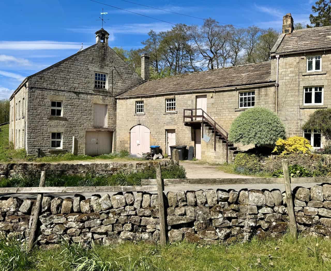
Crossing Wath Bridge, I make my way towards the dam at Gouthwaite Reservoir. I’m a little disappointed when I reach the northern end and discover it’s private, with no public access to walk across and enjoy the full view of the reservoir. Undeterred, I follow a rising footpath that gains a bit of height. From here, I manage to catch some decent views of both the reservoir and the dam. After soaking it in, I continue along the elevated path before descending into the village of Wath, where I pass the remarkable Wath Mill.
ADVERTISEMENT
Pateley Bridge Walk: Wath Mill
Wath Mill, nestled in the quiet village of Wath near Pateley Bridge, is one of Nidderdale’s best-preserved examples of Victorian rural industry. Though the current building dates from the early 19th century, the site has a much longer history of milling, stretching back nearly 500 years. Over the centuries, the mill has adapted to changing needs—spinning flax, turning bobbins, and grinding grain for the local community.

A Timeline of Wath Mill
- 1527: The earliest known corn mill in Wath is built and leased by Fountains Abbey to a miller named Miles Smith.
- 1761: The corn mill and its drying kiln are sold as part of the estate of John Beckwith of Masham.
- Around 1816: A new spinning mill is built on the site by Charles Harrison of Ripon.
- 1824: Advertised for auction in the Leeds Mercury as a flax mill.
- 1838: Listed as a linen mill, with Marmaduke Turnbull recorded as the occupier.
- 1843: The partnership of Mark Hannam and Jacob Pierce, bobbin turners, is dissolved due to bad debt.
- 1859: The mill returns to corn milling, operated by Henry Palmer of Shoreditch, London, under the Nidderdale Union co-operative.
- 1878: A major fire destroys the interior. Millstones fall and are rendered useless.
- 1880: The mill is rebuilt and reopened by miller R. P. Umpleby, who is declared bankrupt the following year.
- 1880–87: Matthew Teal operates the mill as a corn dealer. He is declared bankrupt in 1888 but fits out the mill for Anglican Missionary Services before leaving.
- 1887–1903: Mary Ann Kingham and her sons, Thomas and Percy, take over. Mary also serves as organist at Wath Methodist Chapel.
- Around 1936: The mill closes. T. & A. Stockdale are recorded as its last occupants.
- 1939–1945: During the Second World War, the mill building is cleaned out and repurposed as a workshop for the war effort.
- Late 20th century: Structural repairs and re-roofing help preserve the building.
- 2017: Restoration of the milling machinery and millstones is completed by the Upper Nidderdale Landscape Partnership Scheme.

A Waterwheel at the Heart of Village Life
Wath Mill, as it stands today, was originally constructed around 1816 as a flax-spinning mill. It was later adapted for bobbin turning. From the 1850s, the machinery was once again repurposed for grinding grain—mainly oats, barley, and wheat—on large millstones driven by a waterwheel.
Watermills were a crucial part of rural Britain for centuries. The first recorded water-powered corn mill in Wath dates from 1527, though the original location remains unknown. It is believed to have been moved from Foster Beck, on the opposite side of the River Nidd, to its current site in the early 19th century. The mill as we see it today was fitted with new millstones and machinery following the devastating fire of 1878.
How the Mill Worked
Wath Mill was a marvel of water-powered engineering, with every stage of milling driven by a single waterwheel:
- Waterwheel: The central source of power, turning every piece of machinery within the building.
- Mill Pond: A dam created a pond that provided a steady water supply to keep the wheel turning.
- Channel: Stone-lined drains fed water from Dauber Gill into the pond and then into a wooden header tank.
- Header Tank: This tank released water at a controlled rate onto the wheel, ensuring consistent operation.
- Main Drive Shaft: The rotating waterwheel powered a large horizontal shaft on the ground floor, stretching along much of the building.
- Gears: Large bevel gears on the main shaft engaged with smaller ‘stone nut’ gears, transferring power to vertical shafts that drove the millstones.
- Vertical Auxiliary Shaft: This extended through the first and second floors to power additional machinery.
- Millstones: Four pairs of millstones ground wheat, barley, and oats. The waterwheel powered them directly.
- Drying Kiln: A central fire heated the kiln, drying damp grain on the floor above. Grain had to be below 14% moisture before it could be milled properly.
ADVERTISEMENT
The Sportsman’s Arms, a historic country inn in the village of Wath, comes into view. Set within a 17th-century sandstone building, this family-run inn has a welcoming charm. It offers a bar, a restaurant, and individually styled rooms, making it a popular stop for walkers exploring the Nidderdale Way. Even from outside, it’s easy to imagine how cosy and inviting it must be after a day’s walk.

From Wath, my route back to Pateley Bridge is very straightforward. I follow the Nidderdale Way alongside the River Nidd. This part of the walk is wonderfully peaceful—flat, scenic, and easy on the feet. It’s the perfect way to wind down after everything this Pateley Bridge walk has offered so far.

I finish my Pateley Bridge walk with a gentle stroll through the town’s recreation ground. At its heart stands a charming bandstand, a lovely focal point for this community space. The wrought-iron structure rests on a raised stone platform, surrounded by neatly trimmed lawns and benches. It’s a picturesque spot, offering a calm and pleasant end to what has been a thoroughly memorable walk through the landscape, history, and hidden corners of Nidderdale.

ADVERTISEMENT