Experience Breathtaking Landscapes on the Baysdale Abbey Walk in North Yorkshire
This Baysdale Abbey walk starts at Hob Hole in the North York Moors, where you’ll find a spacious car park. Hob Hole is situated at the eastern end of the Baysdale valley, just under three miles (4.8 kilometres) west of the village of Castleton.
After parking, head north up the road. At the crossroads, take the track on your left, which heads west across Kildale Moor. As you walk, you’ll have the scenic Baysdale valley below you on your left.
After about two miles (3.2 kilometres), take the path across the fields down into the valley. Walk south-west through the valley, enjoying the tranquil surroundings until you reach the site of Baysdale Abbey. Although the original abbey no longer stands, this historic location is still a perfect spot for a rest and some exploration.

Next, from Baysdale Abbey, climb out of the valley heading west, passing Baysdale Farm on your left. At the top, you’ll reach the Cleveland Way. Turn left and follow the Cleveland Way south-west across Battersby Moor. When you reach Tidy Brown Hill, continue south, staying on the Cleveland Way. This section of the track runs across the top of the Greenhow Bank slopes, offering stunning views across the Tees Valley and the Vale of Mowbray. On a clear day, you can see the hills and mountains of the Yorkshire Dales on the horizon.
After approximately 2½ miles (4 kilometres) on the Cleveland Way, take a track to your left across the moorland, walking in a north-easterly direction. Eventually, you will reach another track marked on the Ordnance Survey map as The Flagged Road. Here, turn right and head south-east down into the valley. Then, cross a footbridge and head back out of the valley.

Continue to follow the track north-east, then north across Baysdale Moor for approximately 2¼ miles (3.6 kilometres). Your path then veers east, descending into a small, picturesque ravine where you’ll cross Great Hograh Beck. Ascend from the ravine and continue east across Great Hograh Moor on a path known as Skinner Howe Cross Road.
After about a mile (1.6 kilometres), you’ll reach a minor road. Turn left and follow the road (John Breckon Road) downhill, leading you back to your car park at Hob Hole. This 12-mile (19-kilometre) walk offers plenty of interest, breathtaking views, and invigorating fresh air on the open moorland of the North York Moors. The walk to Baysdale Abbey and the surrounding trails showcase the natural beauty and historical richness of the area.
Baysdale Abbey Walk: Maps and Tools
Visit either the OS Maps website or the Outdooractive website to view this walking route in greater detail. Both platforms offer a range of features, including the ability to print the route, download it to your device, and export the route as a GPX file. You can also watch a 3D fly-over and share the route on social media.
Baysdale Abbey Walk: Distance, Duration, Statistics
Distance: 12 miles
Distance: 19 kilometres
Duration: 5½ hours
Ascent: 1552 feet
Ascent: 473 metres
Type: Circular walk

Recommended Ordnance Survey Map
The best map to use on this walk is the Ordnance Survey map of the North York Moors Western Area, reference OS Explorer OL26, scale 1:25,000. It clearly displays footpaths, rights of way, open access land and vegetation on the ground, making it ideal for walking, running and hiking. The map can be purchased from Amazon in either a standard, paper version or a weatherproof, laminated version, as shown below.
About Baysdale Abbey in the North York Moors
Discovering Baysdale Abbey
Nestled in the serene and picturesque landscape of the North York Moors, Baysdale Abbey is a site of great historical and architectural significance. Located in North Yorkshire, it has a rich history dating back to the medieval period. While the original abbey no longer stands, the current site includes a large farmhouse from the 17th century with 19th-century modifications. It offers a unique glimpse into England’s monastic past. For those interested in exploring this heritage, my Baysdale Abbey walk provides an excellent opportunity to experience the abbey surroundings.
Historical Background of Baysdale Abbey
Founding and Early History
Baysdale Abbey was established as a Cistercian nunnery before 1211. The Cistercian order, known for its austere lifestyle and emphasis on manual labour and self-sufficiency, played a crucial role in the religious and economic life of medieval England. The nunnery was part of a broader network of Cistercian establishments that promoted spiritual and communal living. The location in a remote valley provided the seclusion necessary for the nuns’ contemplative life, which was integral to Cistercian values.
Medieval Period
During its peak, Baysdale Abbey was a vital part of the local community, providing spiritual guidance and contributing to the local economy through agriculture and other activities typical of monastic estates. The abbey faced numerous challenges over the centuries, including the Black Death, which significantly affected the population and resources of monastic communities. Despite these challenges, Baysdale Abbey sustained its operations until the Dissolution of the Monasteries under Henry VIII, which led to the dispersal of its assets and the end of its religious functions.
Architectural Features of Baysdale Abbey
Description of the Original Structure
The original structure of Baysdale Abbey no longer exists, but its historical significance is reflected in the current farmhouse, which includes parts dating back to the 17th century and modifications from the 19th century. The layout of the original abbey would have included a church, cloisters, living quarters, and agricultural buildings, all designed to support the self-sufficient lifestyle of the nuns.
Post-Medieval Modifications
Significant modifications occurred in the 17th century and again in 1822. The left part of the current building dates back to the 17th century, while the central section bears the date 1822. These renovations introduced features such as coursed rubble construction, Welsh slate roofing, and Tudor-arched windows, blending older architectural styles with more contemporary elements. The farmhouse, as it stands today, is a Grade II listed building, preserving its historical and architectural integrity.
Archaeological Discoveries at Baysdale Abbey
Summary of Archaeological Watching Brief (2008)
An archaeological watching brief conducted in 2008 during the conversion of barns and outbuildings into holiday accommodations revealed significant deposits, including a stone wall to the east of the farmhouse. These findings are crucial for understanding the historical layout and development of the abbey site. The discovery of medieval artefacts and structural remains provides valuable insights into the daily life and operations of the nunnery.
Baysdale Abbey Today
Current Usage
Today, Baysdale Abbey has been transformed into holiday accommodation, offering a unique experience for visitors. The abbey can host up to 18 guests, making it ideal for family holidays or special celebrations. Adjacent traditional buildings have been converted into three holiday cottages, accommodating between four to six guests each. These renovations have maintained the historical charm of the abbey while providing modern comforts for visitors. The secluded location, accessed by a 2½-mile single-track road, ensures a peaceful retreat for guests.
Preservation and Conservation Efforts
As a Grade II listed building, Baysdale Abbey is protected under national heritage laws. Historic England has recognised its special architectural and historical interest, ensuring ongoing preservation efforts to maintain its structural and historical integrity. Conservation efforts focus on preserving the original architectural features while allowing adaptive reuse of the site for modern purposes.
Exploring the Surroundings of Baysdale Abbey
The Baysdale Estate
The abbey is part of the expansive Baysdale Estate, which covers 4000 acres of moorland, woodland, and pasture within the North York Moors National Park. The estate provides ample opportunities for walking and exploring, with numerous footpaths radiating from the abbey, allowing visitors to immerse themselves in the natural beauty of the region. The estate’s diverse landscapes offer a habitat for various wildlife, making it a haven for walking enthusiasts. My Baysdale Abbey walk is particularly popular, offering stunning views and a chance to connect with nature.
Nearby Historical Sites
Visitors to Baysdale Abbey can also explore other historical and natural attractions in the vicinity, including the charming village of Westerdale, the scenic routes of the North York Moors, and nearby historical landmarks such as Baysdale Abbey Bridge, also a listed structure. These sites offer additional insights into the region’s rich history and heritage.
A Walk Through Time at Baysdale Abbey
Baysdale Abbey stands as a testament to the rich monastic history and architectural heritage of North Yorkshire. Its transformation into a holiday destination offers a unique blend of historical charm and modern comfort, making it a must-visit for history enthusiasts and walkers alike. Whether you are exploring its ancient walls or walking the moorland paths, including my Baysdale Abbey walk in your itinerary provides a fascinating journey through time.
Baysdale Abbey Walk: My Photos
The moorland path through Baysdale on the north side of Baysdale Beck offers a serene walking experience.
The view south-west into the Baysdale valley, with the Cleveland Hills in the background, is truly breathtaking.

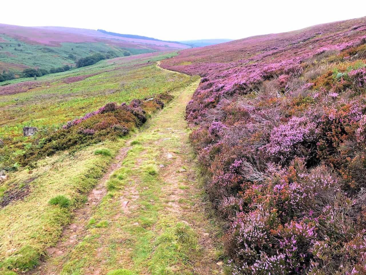
Heading west through Baysdale on the north side of Baysdale Beck reveals stunning contrasts between the purple heather on the right and the green bracken on the left.

These old barns in Baysdale, now in a poor state of repair, tell a story of the area’s history.

The view south-west towards the head of the Baysdale valley captures the essence of this picturesque landscape.

Baysdale Abbey, now holiday properties, lies on the site of a 13th-century Cistercian abbey. This site is a highlight of the Baysdale Abbey walk, blending history with beauty.
Baysdale Farm (right), with Baysdale Abbey in the distance, sits at the head of this beautiful, secluded valley.

The view north-west from Battersby Moor towards Great Ayton and Teesside is a rewarding sight for walkers.

Looking north from the Cleveland Way on Battersby Moor, you can see the distinctive half-cone summit of Roseberry Topping to the left and Highcliff Nab to the right, which overlooks Guisborough.

The Cleveland Way, leading south across the Cleveland Hills to Bloworth Crossing, offers a refreshing walking experience.

The Cleveland Way is a 109-mile (175-kilometre) national trail around the western, northern, and eastern edges of the North York Moors. Officially opened in 1969, it can be walked in either direction and links the towns of Helmsley and Filey. The trail is very much a walk of two halves: an inland section across moorland between Helmsley and Saltburn, and a coastal section along cliff tops between Saltburn and Filey.

Looking down towards Greenhow Botton, enclosed on three sides by the Cleveland Hills, provides a unique perspective.

The Cleveland Way, intersecting with my Baysdale Abbey walk, offers a variety of landscape views.

The view north-west from Ingleby Moor over the Tees Valley lowlands is expansive and impressive.

The view west from Ingleby Moor over the Vale of Mowbray highlights the area’s natural beauty.

Armouth Wath at the bottom of The Flagged Road (Track) is a tranquil place for a break.

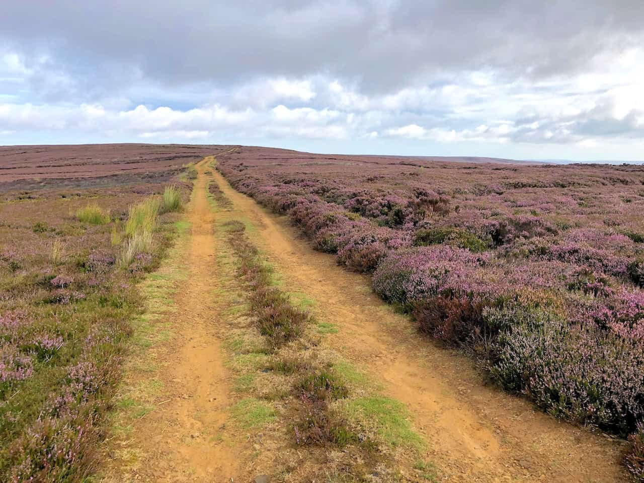
The track across Baysdale Moor is a rugged and rewarding part of the Baysdale Abbey walk.
A lovely, sheltered resting place on Great Hograh Moor, in a small ravine created by Great Hograh Beck, offers a peaceful respite.

The beautiful colour combinations created by the moorlands, farmlands, and woodlands of the North York Moors are a visual treat.

The view of Westerdale from Little Hograh Moor showcases the valley’s charm.

Westerdale, both a valley and a small village, adds a quaint touch to the landscape. The village is just visible behind the trees in the centre of the picture.

John Breckon Road across Little Hograh Moor is part of the diverse terrain on the Baysdale Abbey walk.

Almost back! Hob Hole is just at the bottom of the road, a welcoming sight near the end of the walk.

The footbridge across Baysdale Beck at Hob Hole marks a charming end to the Baysdale Abbey walk.
Amazon’s Top Walking Boots: Four Standout Choices for Men and Women
For walking and hiking, the right boots are essential for both comfort and safety. While Amazon boasts a wide range, certain boots emerge as top-sellers. From those, here are four I personally favour. As an Amazon affiliate, I may earn a small commission from any purchases made through the links provided. This helps support the upkeep of this website. Rest assured, you won’t pay a penny extra, but your purchase will contribute to keeping my site running smoothly. Happy walking!

Berghaus Men’s Hillmaster II Gore-Tex Walking Boots
These fully waterproof leather walking boots feature a Gore-Tex lining, ensuring no water enters whilst allowing feet to breathe and stay cool. Made from full-grain leather, they promise unmatched durability and comfort. The boots come with memory foam tongues and cuffs that mould to your feet for a tailored fit, and the Vibram Hillmaster outsoles offer confidence on challenging terrains.

Salewa Men’s Mountain Trainer Mid Gore-Tex Walking Boots
Made from durable suede and abrasion-resistant textile, these men’s hiking boots are both lightweight and sturdy. The upper material is enhanced by a 360° full rubber sheath. Their dual-layer midsole with Bilight technology ensures ergonomic cushioning and grip, especially on extended hikes. The Vibram Wrapping Thread Combi outsoles allow a natural walking feel, and the Gore-Tex lining provides waterproofing, breathability, and optimal weather protection. Furthermore, the patented Salewa 3F system ensures flexibility, a secure heel grip, and a blister-free fit.

Berghaus Women’s Supalite II Gore-Tex Walking Boots
Specially designed for women, these hiking boots offer waterproofing and breathability, thanks to their Gore-Tex lining. Crafted from full-grain abrasion-resistant leather, they’re durable enough for the toughest hikes. The Supalite soles ensure stability and traction, and the EVA midsoles add comfort for extended walks.

Merrell Women’s Moab 3 Mid Gore-Tex Walking Boots
These hiking boots incorporate a Gore-Tex waterproof membrane, blending breathability with superior waterproof performance. The combination of pigskin leather and mesh on the uppers, along with the suede outer material, ensure durability and style. Enhancements include 100% recycled laces, webbing, and mesh lining. Additionally, bellows tongues, protective toe caps, and Vibram TC5+ rubber soles ensure protection and ease on any terrain.