Detailed Directions for a Blakey Ridge Walk in the North York Moors
Begin your Blakey Ridge walk at the Lion Inn car park. Blakey Ridge, a scenic road, connects the villages of Castleton in the north and Hutton-le-Hole in the south. From the car park, cross the road and walk briefly south. Take the path on your left, signposted ‘Rosedale Railway South’. Start walking downhill until you reach the grey gravelled track, which once served as the route of the Rosedale Railway. Cross straight over the track and continue downhill in a south-easterly direction. Initially, the path may be difficult to spot but becomes clearer as you progress.
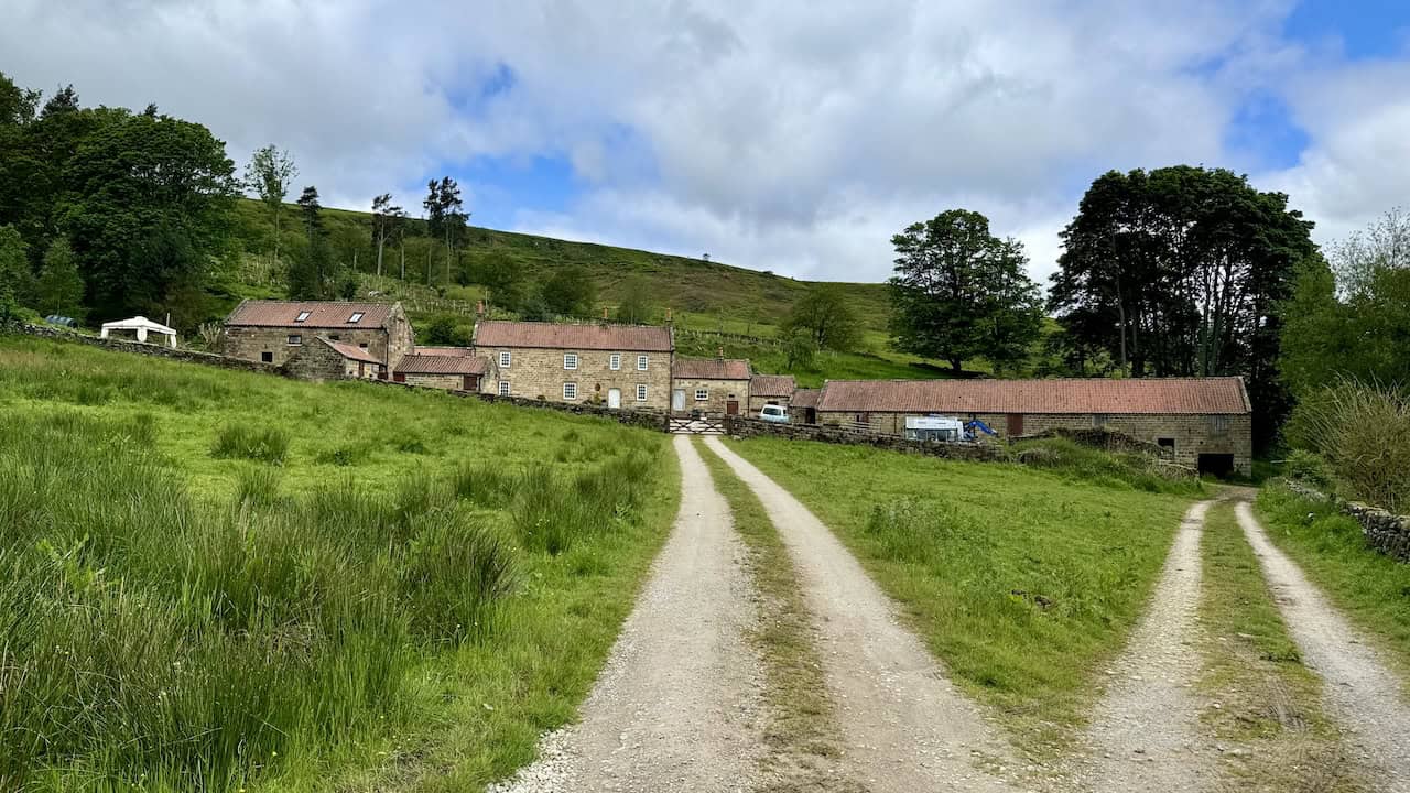
Next, you will reach a wider track that zigzags down the hill to a gate leading into Overend Farm. Walk through the farm and turn right, following the path south to Hollin Bush Farm. Continue through the farm, and shortly you will arrive at Moorlands Farm. Here, take the small road on your left, head downhill briefly, then turn right through a gate to access Daleside Road (Track). Follow this route south through the valley for almost two miles (3.2 kilometres). Along the way, you will pass High House Farm and Medd’s Farm on your right before reaching the quaint hamlet of Thorgill.

In Thorgill, follow the road until it bends to the left. Take the path signposted ‘Footpath to Farndale’. Ascend the steps and pass the cottages on your right. At the top, take a path to your left into some trees and continue uphill. Soon, you will emerge into open countryside on Thorgill Bank. Follow the path up the bank, passing a large square-shaped boulder on your right. The path then veers left and leads uphill to the track bed of the dismantled railway line at the top of the bank.
Turn right and walk along the disused railway line, an easy route with great views on your right. You will pass Thorgill Head and Sheriff’s Pit before reaching an information board at Little Blakey after roughly three miles (4.8 kilometres). This board marks the point to leave the railway line. Take the small path up the hill to a car park by the main road. There are additional information boards here about the Rosedale Railway and its mining history.

Cross the main road and take the smaller road signposted ‘Church Houses’. After a few metres, turn right onto the stone track, which is part of the Esk Valley Walk. Enjoy the excellent views to your left down into the Farndale valley. After about three-quarters of a mile (1.2 kilometres), turn right along a well-trodden path and head up the hill. Pass a small stone building on your right and continue walking until you return to the Lion Inn, completing your Blakey Ridge walk.
This lovely eight-mile (12.9-kilometre) trek in the North York Moors offers beautiful countryside walking through the Rosedale valley and sweeping views along the dismantled railway line. The Blakey Ridge walk is perfect for those who appreciate history, nature, and the scenic beauty of North Yorkshire.
Blakey Ridge Walk: Maps and Tools
Visit either the OS Maps website or the Outdooractive website to view this walking route in greater detail. Both platforms offer a range of features, including the ability to print the route, download it to your device, and export the route as a GPX file. You can also watch a 3D fly-over and share the route on social media.
Blakey Ridge Walk: Distance, Duration, Statistics
Distance: 8 miles
Distance: 12¾ kilometres
Duration: 3¾ hours
Ascent: 919 feet
Ascent: 280 metres
Type: Circular walk

Recommended Ordnance Survey Map
The best map to use on this walk is the Ordnance Survey map of the North York Moors Western Area, reference OS Explorer OL26, scale 1:25,000. It clearly displays footpaths, rights of way, open access land and vegetation on the ground, making it ideal for walking, running and hiking. The map can be purchased from Amazon in either a standard, paper version or a weatherproof, laminated version, as shown below.
About Blakey Ridge
Blakey Ridge is a prominent elevated landform situated in the central part of the North York Moors, North Yorkshire, England. This ridge runs in a north-to-south direction, forming a natural divider between the valleys of Rosedale to the east and Farndale to the west. The ridge’s highest point reaches 404 metres (1325 feet) and extends approximately three miles in length.
Blakey Ridge is characterised by its steeply sloping sides that fall away from the crest, offering dramatic views over the surrounding dales. A road traverses the ridge, connecting the village of Castleton in the north to Hutton-le-Hole in the south, a distance of about 16 miles. This road makes the ridge accessible and is popular among visitors for its scenic beauty.
At the northern end of Blakey Ridge lies The Lion Inn, a historic public house dating back to the mid-16th century. This inn is a notable landmark and offers hospitality to walkers and travellers who want to enjoy a drink or a nice meal. Just half a mile south of The Lion Inn is a large car park at Little Blakey, frequently used by walkers exploring the numerous routes in Rosedale and Farndale.
A favourite walk along Blakey Ridge follows the historical trackbed of the Rosedale Railway. Built during the ironstone mining boom of the 1800s, this railway played a crucial role in transporting ironstone from the mines. The ridge has a rich industrial heritage, with many remnants of the mining era still visible today. In addition to the Blakey Ridge walk on this page, I have written about two others starting from Blakey Ridge. For more details, visit my Rosedale Railway Walk or my Rosedale Abbey Railway Walk.
The terrain of Blakey Ridge is predominantly heather moorland, a typical landscape of the North York Moors. This open moorland supports a variety of wildlife, including birds such as the curlew and golden plover. The sweeping views from the ridge over the surrounding valleys add to its charm, making it a favoured spot for visitors and walkers.
Blakey Ridge Walk: My Photos
The path leading from the Lion Inn downhill to the disused railway line marks the beginning of the Blakey Ridge walk. It crosses the railway line and continues straight ahead downhill. In the distance, the sun beautifully illuminates the green fields of the Rosedale valley.

Shortly after crossing the railway line, the path becomes faint and difficult to spot. Careful observation reveals where other hikers have trodden, but it soon becomes easier to follow.

Further down the hill, the grassy path becomes more defined, following a narrow channel in the ground. The views down into Rosedale are lovely, with the iron and stone kilns of the East Mines visible on the far side of the valley.

As I descend the slopes during the Blakey Ridge walk, the view looking north towards the head of the Rosedale valley is stunning.

Continuing downhill, the rooftops of Overend Farm become visible, my intended destination on the Blakey Ridge walk. On the map, the path appears to lead straight through the heather, but the easier route is a wider track that zigzags downhill to reach the farm. Beyond Overend Farm, to the right, lies Dale Head Farm, a popular spot for walkers due to its café facilities.

The easier track descends downhill towards Overend Farm, with the head of Rosedale fully lit by the sun’s rays.

The route through Overend Farm reveals beautiful, lush green countryside.

Looking back at Hollin Bush Farm as I make my way to Moorlands Farm, the landscape is captivating.

The narrow road from Moorlands Farm leads down to Daleside Road (Track). I use ‘Track’ in brackets as it is labelled on the Ordnance Survey map, distinguishing it from the minor road also called Daleside Road on the eastern side of the valley floor.

The view east from Daleside Road (Track) across the valley towards the iron and stone kilns is particularly striking.

Daleside Road (Track) is wide and easy to navigate. Although there are a few boggy sections en route, they are not too challenging. A handy old tree trunk provides a perfect spot for a sit-down and a coffee from the flask.

The view east from Daleside Road (Track) towards the Rosedale Stone Kilns, featuring 16 magnificent arches, is truly impressive.

Another view east from Daleside Road (Track) shows the Rosedale Iron Kilns on the left and the Rosedale Stone Kilns on the right.

As I approach High House Farm, Daleside Road (Track) transitions from a grassy route to a more substantial stone track.

Looking back at Hall House, a farm and holiday let near High House Farm, the scenery remains beautiful.
High House Farm is perched on the hillside as I look west from Daleside Road (Track).

The route south-east past High Thorgill Farm and a few charming cottages is quite picturesque.

Passing through the quaint hamlet of Thorgill, the charm of the area is evident.

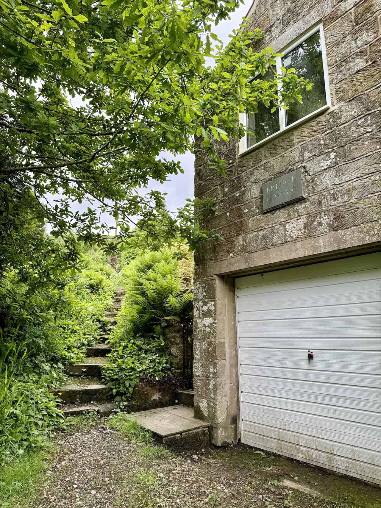
After passing through Thorgill, the route is on the right and is marked by a green signpost, ‘Footpath to Farndale’.

Immediately after turning right at the green sign, the path passes the garage of Bridge Cottage and then ascends a set of steps.
After climbing the steps, the path passes a group of cottages on the right and then reaches a track at the top. The path I need is just on the left before a small car park. It’s a bit hidden, with further steps leading uphill through the trees.

The path through the trees emerges into the open countryside of Thorgill Bank. Progressing upwards, the path is marked by a distinctive large square-shaped boulder on the right-hand side.

The view from Thorgill Bank looking back down to Thorgill and Low Thorgill Farm, nestled in the bottom of the Rosedale valley, is magnificent and adds to the charm of the Blakey Ridge walk.
The climb out of Rosedale up Thorgill Bank eventually leads to the disused railway line, a notable point on the Blakey Ridge walk.

The beautiful views of the Rosedale valley from the disused railway line are breathtaking and well worth the effort.

Sheriff’s Pit, located by the side of the railway line, includes an interpretation board explaining its history as a vertical shaft used to extract ironstone during the Rosedale Railway’s operation.

The path of the dismantled railway line is extremely easy to follow. It’s a relaxing walk with no inclines and offers great views to the right of Rosedale, making it a highlight of the Blakey Ridge walk.
Another interpretation board by the side of the line provides information about Blakey Junction. This is the point where I leave the line to my left and take the short walk up to the Little Blakey car parking area.

A section of the Esk Valley Walk appears after crossing the road on Blakey Ridge, providing more scenic views.

There are great views down into the Farndale valley from the Esk Valley Walk just above Round Crag.

The approach to the Lion Inn on Blakey Ridge offers a sense of arrival and accomplishment.
The Lion Inn, located on Blakey Ridge, is a historic public house dating back to the mid-16th century. Completed between 1553 and 1558, the inn has served travellers for over four centuries. Situated at 404 metres above sea level, it is known as the fourth highest pub in England. The Lion Inn is renowned for its scenic location on the North York Moors and its extreme weather conditions, particularly heavy snowfall. Historically, the inn catered to miners during the ironstone boom in Rosedale.

The Lion Inn is a popular stop for walkers and cyclists exploring the North York Moors. It serves as a waypoint on notable routes such as the Coast to Coast Walk and the Lyke Wake Walk. The inn’s remote and picturesque setting has also made it a favourite filming location, including segments of the BBC series ‘Top Gear’. Additionally, it has hosted a variety of musical performances by artists such as Chris Rea, Slade, Sandie Shaw, Gene Pitney, Neil Sedaka, Helen Shapiro, and Sting.

Highly Rated Osprey Hiking Backpacks for Outdoor Enthusiasts
Osprey’s reputation for crafting high-quality hiking backpacks is well-established, offering a range of options that cater to both men and women. The following four backpacks stand out for their excellent sales and customer ratings on Amazon, making them a top choice for outdoor enthusiasts seeking reliability and comfort. As an Amazon affiliate, I may earn a small commission from any purchases made through the links provided. This helps support the upkeep of this website. Rest assured, you won’t pay a penny extra, but your purchase will contribute to keeping my site running smoothly. Happy walking!

Osprey Tempest 20 Women’s Hiking Backpack
The Tempest 20 stands out as the ideal solution for day-hiking, biking, or peak-bagging, tailored specifically for women. It features a panel-loading design for ease of access, complemented by an internal zippered mesh pocket with a key clip for secure storage. Unique to this model are the Stow-on-the-Go trekking pole and LidLock bike helmet attachments, enhancing its versatility. Side stretch mesh pockets, along with an easy-access, expandable stretch mesh harness pocket, offer ample storage. Additionally, it includes a blinker light attachment (light not included) and a large stretch mesh front panel pocket for extra carrying capacity.

Osprey Talon 22 Men’s Hiking Backpack
Designed for the active adventurer, the Talon 22 provides an optimal panel-loading design suitable for day-hiking, biking, or peak-bagging. Key features include dual-zippered panel access to the main compartment and a tuck-away ice ax attachment with a bungee tie-off. It boasts a top panel zippered slash pocket for quick access items and lower side compression straps for load management. An external hydration reservoir sleeve and dual-zippered fabric hipbelt pockets enhance hydration and storage, while a large stretch mesh front panel pocket increases its utility for various activities.

Osprey Tempest 30 Women’s Hiking Backpack
The Tempest 30, designed with a women’s-specific fit, is a streamlined top-loader ideal for both extensive day trips and light-and-fast overnight adventures. It includes a fixed top lid with an external zippered slash pocket and an under-lid zippered mesh pocket with a key clip for organised storage. The pack features a tuck-away ice ax attachment with a bungee tie-off, dual upper and lower side compression straps for load adjustment, and an external hydration reservoir sleeve. For added convenience, it offers an easy-access, expandable stretch mesh harness pocket and dual-zippered fabric hip-belt pockets.

Osprey Talon 33 Men’s Hiking Backpack
The Talon 33 is engineered for dynamic movement, making it the perfect streamlined top-loader for committed day trips or light-and-fast overnight excursions. It features top load access to the main compartment for easy packing and retrieval. The backpack is equipped with a large stretch mesh front panel pocket, Stow-on-the-Go trekking pole attachment, and stretch mesh side pockets for versatile storage options. Additionally, an easy-access, expandable stretch mesh harness pocket and dual-zippered fabric hip-belt pockets offer convenient storage solutions for essential gear.