Discover Stunning Railway Stations on the Grosmont to Goathland Walk
This Grosmont to Goathland walk begins at the Grosmont Car & Coach Park, located just west of the village centre. The car park is in a wooded area opposite the cricket field. After parking, you have two options for leaving the car park. The first option is to take the steps signposted ‘Station & Village via footbridge’. This path leads you to the old Grosmont Ironworks site. You’ll pass between two brick structures that were once part of the overhead conveyor transporting ironstone from the mine to the smelter. After that, you will see four display boards and a cast iron model of the ironworks. From there, head over the railway footbridge to reach the platforms of Grosmont Railway Station.
Alternatively, you can leave the car park via its main entrance, taking the route signposted ‘Station & Village avoiding footbridge’. As you exit the car park, you will see the cricket field in front of you. Turn left onto Front Street. Walk along the road, passing under the railway bridge where you’ll see public toilets on your right. Continue along Front Street towards the village. Cross the railway level crossing and turn immediately right, taking the footpath to the NYMR engine sheds.

Proceed along the path across a large iron footbridge over the river, and soon you will see two railway tunnels ahead. Although a path leads through the smaller tunnel, do not take this route. Instead, take the path left, signposted Rail Trail to Goathland, and ascend the hill past the Old Coffee Shop and St Matthew’s Church. Continue uphill through the gates and turn right to reach the top of the bank, where there is a bench offering a lovely view of Grosmont below. Another sign will direct you to the Rail Trail to Goathland.
As you descend the hill, you will pass a viewing area for the NYMR engine sheds. Soon, you will reach the original track bed of the railway line. Stay on the well-signposted Rail Trail to Goathland. This main route is straightforward, well-defined, flat, and generally straight. You will find plenty of benches along the way to rest and enjoy the scenic countryside.

Along the route, look out for several landmarks, including a row of old railway cottages, North Bridge, the Twin Arch Bridge, and the site of the original Beck Hole Station. After passing Beck Hole Station, you will come across Intake Cottage on your left. Here, you will begin a gentle uphill incline for about two-thirds of a mile. At the top of this incline, you will reach a set of gates and a road. Turn right at the road and walk uphill, which will lead you to the village green at Goathland, where you will see the memorial cross.
At the junction, turn left and take the road signposted to the railway station. As you walk through the village, enjoy the various shops and cafes along the way. Continuing forward, you will pass The Goathland Hotel on your right and Scripps Garage on your left, both of which featured in the popular ITV series Heartbeat. The road then continues downhill, leading you to the charming Goathland Railway Station.
Upon reaching Goathland Railway Station, you can retrace your steps back to your starting point at Grosmont. This Grosmont to Goathland walk from Grosmont Car & Coach Park to Goathland Station is a linear walk, approximately 3¾ miles (6 kilometres) each way, making it about 7½ miles (12 kilometres) in total. Alternatively, you can choose to walk just one way from Grosmont to Goathland Station and take the train back.
Grosmont to Goathland Walk: Maps and Tools
Visit either the OS Maps website or the Outdooractive website to view this walking route in greater detail. Both platforms offer a range of features, including the ability to print the route, download it to your device, and export the route as a GPX file. You can also watch a 3D fly-over and share the route on social media.
Grosmont to Goathland Walk: Distance, Duration, Statistics
Distance: 7½ miles
Distance: 12 kilometres
Duration: 3½ hours
Ascent: 721 feet
Ascent: 220 metres
Type: Linear walk

Recommended Ordnance Survey Map
The best map to use on this walk is the Ordnance Survey map of the North York Moors Eastern Area, reference OS Explorer OL27, scale 1:25,000. It clearly displays footpaths, rights of way, open access land and vegetation on the ground, making it ideal for walking, running and hiking. The map can be purchased from Amazon in either a standard, paper version or a weatherproof, laminated version, as shown below.
About Grosmont Railway Station
Grosmont Railway Station, nestled in the scenic Esk Valley, serves as a crucial junction for both the heritage North Yorkshire Moors Railway (NYMR) and the Esk Valley Line. This station, steeped in history, offers visitors a glimpse into the golden age of steam travel and the industrial era that profoundly influenced the region.
Historical Significance
The railway history of Grosmont dates back to 1835 when George Stephenson designed the original tunnel and railway infrastructure. Initially, horse-drawn carriages traversed these tracks, making it one of the earliest passenger railway systems globally. When steam locomotives were introduced in 1847, tunnels and bridges had to be expanded to accommodate the larger engines.
Grosmont, once an industrial hub due to its rich ironstone deposits, saw the establishment of Grosmont Ironworks in 1862. The ironworks, equipped with three blast furnaces, played a pivotal role during the Victorian Industrial Revolution, producing nearly 1000 tonnes of pig iron weekly at its peak. Although the ironworks closed in 1891, remnants of this era, such as the stone and brick base of one of the furnaces, still stand today.
Grosmont Today
Currently, Grosmont Railway Station is renowned for its heritage services operated by the NYMR. The station, themed around the 1950s, serves as the headquarters for the NYMR’s operating and engineering activities. Visitors can explore the engine sheds where steam and diesel locomotives are maintained and restored.
The station also marks the beginning of the scenic 3½-mile Rail Trail to Goathland, following the original route of Stephenson’s railway. This trail provides breathtaking views of the North York Moors and is particularly popular during spring when the woods are adorned with bluebells.
Attractions and Activities
Grosmont Station is more than just a railway stop; it is a gateway to numerous attractions and activities. The station itself features a shop, a cafe, and the Station Tavern is close by, perfect for refreshments. Additionally, the village hosts Britain’s oldest independent co-op, the Grosmont Co-operative Society Ltd, established in 1867.
The NYMR operates daily services from Easter to the end of October, with special events and services throughout the year. The station also participates in England’s largest festival of history and culture, Heritage Open Days, offering free access to various heritage events and activities.
Guided tours of the station are available, providing an in-depth look at its historical and operational aspects. These tours, suitable for all ages, delve into the rich history of the station and the village, highlighting the impact of the railway on local development.
Grosmont to Goathland Walk: My Photos
Nestled in the woodland where the car park is located, this seating area features four informative display boards. Remarkably, this serene woodland was once the bustling site of Grosmont Ironworks. For nearly 30 years during the Victorian Industrial Revolution, iron was smelted here. Established in 1862, Grosmont Ironworks eventually boasted three blast furnaces and a towering chimney that overshadowed the village, reaching higher than the woodland trees today. Hundreds of workers produced nearly 1000 tonnes of pig iron weekly, creating large mounds of waste material known as slag. Although the ironworks closed in 1891 and the buildings were largely demolished, it took another 50 years to remove all the slag. The landmark chimney stood until 1957. Other industrial relics still remain, including the stone and brick base of one of the furnaces. In addition to the display boards, there is a cast iron model of the ironworks.
It is astonishing to think this North York Moors woodland was once an industrial site. However, nature quickly reclaimed the area. Challenging soil conditions on long-contaminated sites like this meant that hardy but unusual plant species were the first to take root, including twayblade, dyer’s rocket, Savoy hawkweed, and sickle medick. Furthermore, willow trees grew rapidly, and their leaf litter enriched the soil, paving the way for silver birch, sycamore, and ash.

Opposite the woodland car park on the eastern side of Grosmont village lies the sports field, home to Grosmont Cricket Club. I have fond memories of watching cricket here on Saturday afternoons.

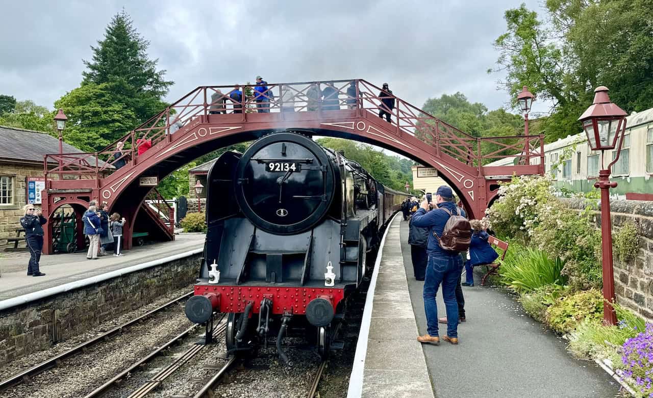
This is Grosmont Railway Station, and I’m fortunate to witness a steam train departing as I arrive. The station is a delightful place to spend time. There are benches to sit on and watch the activities, a station shop, a cafe, and toilet facilities. It’s a wonderfully relaxing spot. Additionally, the Station Tavern next to the station is perfect if you fancy a beer.


Grosmont is proud to host Britain’s oldest independent co-op, the Grosmont Co-operative Society Ltd, which has been serving the community since August 1867.

The Northallerton Station clock is attached to one of the buildings at Grosmont Station. This clock, dating from 1870, was salvaged from Northallerton Station and presented to the Northallerton Group of the North Yorkshire Moors Railway (NYMR) by Waller Thompson of Northallerton. The derelict clock was meticulously rebuilt by Mr. R.C. Place of Appleton Wiske and funded by the Northallerton Area Group. The restored clock was presented to the NYMR on 8th October 1985 by Sidney Weighell, in memory of John Maidwell (1931 – 1989), the former chairman of the Northallerton Station Group, who spearheaded the clock’s restoration.

On the opposite side of the road from the main station buildings is a public viewing area. It was created as part of a programme of improvements to Grosmont Station, marking the 150th anniversary of the railway. The work was undertaken by the Botton Village Community Programme Agency and financed by the North York Moors National Park Committee. My Grosmont to Goathland walk passes this charming area en route to the church.
Shortly after passing the viewing area on my Grosmont to Goathland walk, a large iron footbridge crosses the Murk Esk river. The river flows a bit further west before joining the River Esk, which then flows north-east to the North Sea at Whitby.

The tunnel on the left in this picture, where the two people are walking towards, was one of the world’s first passenger railway tunnels, used by George Stephenson’s horse-drawn carriages. It is much smaller than the adjacent tunnel on the right, which is used by the railway line today. This is because the line’s tunnels and bridges had to be enlarged once steam locomotives were introduced after 1847. There is a path through the tunnel to see the engine sheds of the North Yorkshire Moors Railway, although this is not the way to Goathland. The way to Goathland is indicated on a signpost near this spot as Rail Trail Goathland and leads to the left up the hill towards the church.

This path leads up past the Old School Coffee Shop and St Matthew’s Church. My Grosmont to Goathland walk now essentially follows the Rail Trail and is well signposted. The Rail Trail is the route of the original railway line built by George Stephenson.

The Rail Trail passes by the right-hand side of St Matthew’s Church. St Matthew’s Church, Grosmont, was built in 1875 to the design of Armfield and Bottomley, replacing an earlier church from 1840. The building was funded largely by Charles and Thomas Bagnall, local ironmasters, and Mrs Mary Clarke, a sister of the Revd Dr William Scoresby, the Whitby navigator and polar explorer.

After passing the church and climbing a bit further uphill, I reach the top of the bank, where there is an amazing viewing area. The interpretation board explains that from this vantage point overlooking the village of Grosmont, you can see back into the past. It features a photograph showing the positions of the blast furnaces and chimney of the Grosmont Ironworks on the site of the car park and woodland area where I started my Grosmont to Goathland walk. A signpost nearby again directs the way to Goathland on the Rail Trail.

Following the path from the viewing area, I soon reach another viewpoint which overlooks the engine sheds and workshops of the North Yorkshire Moors Railway. There is also a bench to sit on and enjoy the view.

The Rail Trail follows a section of the original track of the Whitby to Pickering Railway, which opened in 1836 and was built by George Stephenson as a horse-drawn tramway. It was later purchased by George Hudson, the ‘Railway King’, in 1845 and upgraded to accommodate steam locomotives. The line remained in regular use until 1865. As seen in the picture, the Rail Trail is an easy-going route with minimal inclines.
This row of railway cottages is located about three-quarters of a mile south of Grosmont, alongside the Rail Trail. I admire how each cottage is painted in different pastel colours.

Shortly after the railway cottages, there is a charming wooden bridge that crosses the Murk Esk. While the bridge is on the left-hand side and not part of this Grosmont to Goathland walk, it’s a pleasant spot to stand and watch the river flowing below.

This picture may seem a bit unusual. By the side of the Rail Trail, there is a sign with the heading ‘Murkside Mines’. The sign explains that if you follow a path into a field for about 100 metres, you will find peculiar heaps of disfigured black rock. This rock is ironstone, which was mined in this area many years ago. After mining, the ironstone was roasted to remove impurities and reduce its weight before transportation. However, this pile of black rock probably got too hot, resulting in an unusable lump of fused ironstone and waste. Mistakes like this were costly, as they ruined the iron inside the stone. The ‘treasure’ here was abandoned to the elements.


This is the Rail Trail on the Grosmont to Goathland walk. The trail is a peaceful, narrow path flanked by lush greenery, with numerous benches positioned invitingly. Sheep graze along the trail, adding to the pastoral charm of the scene. The landscape features rolling hills in the background, dotted with trees and enclosed fields. This trail offers a picturesque and tranquil walking experience in the heart of the North York Moors countryside.
The Rail Trail generally follows the course of the Murk Esk through the valley. Occasionally, you can get down to the water’s edge. Although the river looks brown and dirty, it is actually clean, providing a habitat where fish and wildlife thrive. The brown colour is due to the water running off the moors, where it has dissolved peat, giving it the brown appearance.

Just over 1½ miles (2.4 kilometres) along the Rail Trail from Grosmont is a lovely footbridge that crosses the Murk Esk. The bridge is called North Bridge. Although now a footbridge, it once carried heavy steam trains across the river. Before walking onto this bridge, note that there is another path on the left-hand side. The path leads into woodland and, if taken, will eventually bring you back to the same place. However, crossing the bridge is probably the easier route, as the path on the other side has a better, smoother surface to walk on.


A bit further on from North Bridge is the Twin Arch Bridge. Once again, it crosses the Murk Esk river and was used by steam locomotives. As you cross the bridge on the Rail Trail, you will find an interpretation board explaining the history of the bridge. From the bridge, a small footpath leads down some steps to provide the view shown in my picture.

By the side of the track is a lovely bench depicting a Victorian lady and gentleman travelling along the line in a horse-drawn coach.

This area, about 2¼ miles (3.6 kilometres) south of Grosmont, is the site of Beck Hole Station. An interpretation board explains the area’s history. A signpost indicates a path to Beck Hole on the left, which is worth a detour if you want to explore the village or get a drink from the pub. However, to continue to Goathland, proceed straight over the bridge, with Goathland being about a mile (1.6 kilometres) further.


Not long after crossing the bridge, the route passes by the front of Intake Cottage.

After Intake Cottage, the route climbs upwards for about two-thirds of a mile (1 kilometre). While the incline is gentle, benches along the way provide resting spots for those who need a break.


At the top of the incline, there is a set of wooden gates. You can continue straight on following the Rail Trail, but I decided to turn right and walk up the road to experience the best of what Goathland has to offer.

After turning right at the gates and walking up the road, there is an old stone footpath by the side of the road, passing a large cream house on the left-hand side.

At the top of the road is the village green of Goathland. A wooden bench and a memorial cross mark the spot. The shops and cafes come into view. I’m turning left here and walking past the shops and cafes towards Goathland Station.


Continuing my Grosmont to Goathland walk, I pass Aidensfield Stores, which has a distinctive red and cream exterior. This building is well-known for its role in Heartbeat, where it served as the village’s grocery and provision merchants. The store’s large windows display a variety of memorabilia, making it a nostalgic stop for fans of the show.

Continuing along the road towards the station, I pass The Goathland Hotel, another prominent landmark in Goathland. It was used to shoot many scenes in Heartbeat, where it was called the Aidensfield Arms. One of the gable ends of the pub still has a sign that reads Aidensfield Arms, while the others read The Goathland Hotel.

This is Scripps Garage and Funeral Services in Goathland, opposite The Goathland Hotel. It’s a notable landmark, primarily known for its role in the popular British TV series Heartbeat, which aired from 1992 to 2010. The garage was run by the character Bernie Scripps in the series.

The Inn on the Moor is next to Scripps Garage. I love the three cast iron sheep in the garden.

This is the road leading down to Goathland Railway Station. The road crosses Eller Beck and ends at the back of the station. The route to the railway station platforms is between the stone weighbridge building on the right and the wooden station shop on the left.


A great atmosphere awaits at Goathland Railway Station. I really enjoy spending time here, especially when the steam trains are running.

Amazon’s Top Walking Boots: Four Standout Choices for Men and Women
For walking and hiking, the right boots are essential for both comfort and safety. While Amazon boasts a wide range, certain boots emerge as top-sellers. From those, here are four I personally favour. As an Amazon affiliate, I may earn a small commission from any purchases made through the links provided. This helps support the upkeep of this website. Rest assured, you won’t pay a penny extra, but your purchase will contribute to keeping my site running smoothly. Happy walking!

Berghaus Men’s Hillmaster II Gore-Tex Walking Boots
These fully waterproof leather walking boots feature a Gore-Tex lining, ensuring no water enters whilst allowing feet to breathe and stay cool. Made from full-grain leather, they promise unmatched durability and comfort. The boots come with memory foam tongues and cuffs that mould to your feet for a tailored fit, and the Vibram Hillmaster outsoles offer confidence on challenging terrains.

Salewa Men’s Mountain Trainer Mid Gore-Tex Walking Boots
Made from durable suede and abrasion-resistant textile, these men’s hiking boots are both lightweight and sturdy. The upper material is enhanced by a 360° full rubber sheath. Their dual-layer midsole with Bilight technology ensures ergonomic cushioning and grip, especially on extended hikes. The Vibram Wrapping Thread Combi outsoles allow a natural walking feel, and the Gore-Tex lining provides waterproofing, breathability, and optimal weather protection. Furthermore, the patented Salewa 3F system ensures flexibility, a secure heel grip, and a blister-free fit.

Berghaus Women’s Supalite II Gore-Tex Walking Boots
Specially designed for women, these hiking boots offer waterproofing and breathability, thanks to their Gore-Tex lining. Crafted from full-grain abrasion-resistant leather, they’re durable enough for the toughest hikes. The Supalite soles ensure stability and traction, and the EVA midsoles add comfort for extended walks.

Merrell Women’s Moab 3 Mid Gore-Tex Walking Boots
These hiking boots incorporate a Gore-Tex waterproof membrane, blending breathability with superior waterproof performance. The combination of pigskin leather and mesh on the uppers, along with the suede outer material, ensure durability and style. Enhancements include 100% recycled laces, webbing, and mesh lining. Additionally, bellows tongues, protective toe caps, and Vibram TC5+ rubber soles ensure protection and ease on any terrain.