Discover the Scenic Goathland to Grosmont Walk in North Yorkshire
Your Goathland to Grosmont walk begins at the Goathland Car Park on Beck Hole Road, located in the heart of the village centre. From the car park, head to the main road, called The Green, and turn left, following the signs for Goathland Station. Footpaths on both sides of the road ensure a safe walk. As you proceed towards the station, you will pass the Goathland Hotel on your right and Scripps Garage and Funeral Services on your left. The road then descends towards the picturesque Goathland Station.
After exploring the charming station, walk back up the hill and continue along The Green, passing various attractive shops and cafés on your left. When you reach the top of the road near the village green and memorial cross, take a right turn down the road signposted to Beck Hole. Follow this road past the village hall on your left and a large cream house on your right. As you descend the hill, turn left at the gates at the bottom, following the sign for Rail Trail Grosmont.

The Rail Trail is a straightforward track leading you three miles (4.8 kilometres) to the village of Grosmont. This route follows the trackbed of George Stephenson’s Whitby and Pickering Railway. Initially, you will head downhill past Incline Cottage to the site of Beck Hole Station. The trail then continues north through the valley, following the course of the Murk Esk river. Along the way, you will encounter landmarks such as the Twin Arch Bridge, North Bridge, the Esk Valley railway cottages, and the Esk Valley ironstone mine.
This Goathland to Grosmont walk is easy to navigate, with signposts marking the way. After passing the railway cottages, continue for about another half a mile (0.8 kilometres) until the track leads up to a viewing area of the North Yorkshire Moors Railway engine sheds. From here, you will then ascend to the top of a grassy bank, offering splendid views down to Grosmont. Turn right and head downhill through a gate to reach the village. You will pass St Matthew’s Church and the Old School Coffee Shop on your right.

Continue walking across a large iron footbridge and through the railway viewing area with numerous benches, ultimately reaching Grosmont Railway Station. The station, bustling with activity, especially when steam locomotives are running, is a delightful place to spend some time. It features a shop, toilets, a café, and a pub called the Station Tavern by the railway level crossing.
After enjoying Grosmont Railway Station, you can either retrace your steps along the Rail Trail back to Goathland or, if you prefer, hop on a train. The walk from Goathland Railway Station to Grosmont Railway Station is approximately 3½ miles (5½ kilometres) one way. Thus, your Goathland to Grosmont walk, round trip, will be roughly 7 miles (11¼ kilometres).
Goathland to Grosmont Walk: Maps and Tools
Visit either the OS Maps website or the Outdooractive website to view this walking route in greater detail. Both platforms offer a range of features, including the ability to print the route, download it to your device, and export the route as a GPX file. You can also watch a 3D fly-over and share the route on social media.
Goathland to Grosmont Walk: Distance, Duration, Statistics
Distance: 7 miles
Distance: 11¼ kilometres
Duration: 3¼ hours
Ascent: 664 feet
Ascent: 202 metres
Type: Linear walk

Recommended Ordnance Survey Map
The best map to use on this walk is the Ordnance Survey map of the North York Moors Eastern Area, reference OS Explorer OL27, scale 1:25,000. It clearly displays footpaths, rights of way, open access land and vegetation on the ground, making it ideal for walking, running and hiking. The map can be purchased from Amazon in either a standard, paper version or a weatherproof, laminated version, as shown below.
About Goathland Railway Station
Goathland Railway Station, nestled in the scenic North York Moors National Park, is a charming and historically significant site. Opened on 1 July 1865 as part of the Whitby and Pickering Railway, the station showcases the quintessential architecture of rural Victorian-era stations. Its traditional stone buildings, vintage platform furnishings, and cast-iron footbridge create a nostalgic atmosphere that transports visitors back in time.
A Heritage Railway Experience
The station is a key part of the North Yorkshire Moors Railway (NYMR), a heritage railway that operates preserved steam and diesel trains between Pickering and Whitby. This line, originally designed by the renowned engineer George Stephenson, offers scenic journeys through the picturesque landscapes of the North York Moors. The NYMR is not only a functional railway but also a living museum, preserving the rich history of railway travel in England.
Film and Television Fame
Goathland Railway Station gained significant fame as a filming location for several popular television series and films. Most notably, it served as ‘Aidensfield’ station in the long-running ITV series Heartbeat, which aired from 1992 to 2010. The station also portrayed ‘Hogsmeade’ station in the first Harry Potter film, Harry Potter and the Philosopher’s Stone. Its picturesque setting and period features made it an ideal location for these productions, further cementing its status as a beloved cultural landmark.
Visitor Attractions and Goathland Walks
Goathland Station is more than just a historic site; it is a vibrant destination for tourists. The station features a delightful tea room, housed in a converted 1922 goods shed, where visitors can enjoy a range of hot and cold drinks, savouries, and sweet treats. There is also a gift shop where you can purchase memorabilia and local products.
For those who love walking, the Rail Trail from Goathland to Grosmont offers a wonderful three-and-a-half-mile walk down the old railway line, combining natural beauty with historical interest. The nearby village of Goathland is just a short walk from the station and offers a variety of cafes, shops, and pubs, making it a perfect spot for a relaxing day out.
Additionally, I have written another walk on my website, which starts from Goathland. This child-friendly walk is suitable for the whole family, providing an enjoyable and accessible outdoor activity. You can find the details of this walk here:
Goathland Walk: The Perfect Family-Friendly Day Out for All Ages
Preservation and Heritage
The station itself is a Grade II listed building, recognised for its architectural and historical importance. The listing includes various structures within the station complex, such as the footbridge, the goods shed, and the water crane. The preservation efforts by the NYMR and other heritage organisations ensure that Goathland Station remains a pristine example of Victorian railway architecture and continues to educate and delight visitors.
Goathland to Grosmont Walk: My Photos
This is the Goathland Hotel, located on the road from the car park to Goathland Railway Station. Many scenes from the popular British TV series Heartbeat, which aired from 1992 to 2010, were filmed here. In the show, it was called the Aidensfield Arms, and one of the pub’s gable ends still has a sign that reads ‘Aidensfield Arms’.

Opposite the Goathland Hotel is Scripps Garage and Funeral Services, also famous for its role in Heartbeat. The garage was run by the character Bernie Scripps in the series.

Next to Scripps Garage is the Inn on the Moor. It boasts a large beer garden with three cast iron sheep looking over the front garden wall.

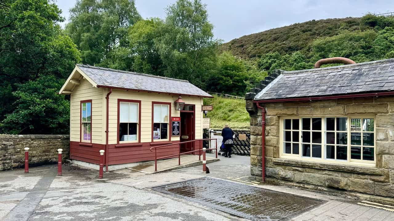
Continuing along the road and down the steps leads to Goathland Railway Station. This is a fantastic place to explore before heading back up the hill to continue my Goathland to Grosmont walk through the village.

Goathland Railway Station is a charming spot to spend time. I was fortunate to be there when a steam train pulled into the station. It’s a bustling place with lots of activity and a great atmosphere. Opened on 1 July 1865 as part of the Whitby and Pickering Railway, the station’s architecture typifies rural Victorian-era stations, featuring traditional stone buildings, a footbridge, and old-fashioned platform furnishings. It is part of the North Yorkshire Moors Railway (NYMR), a heritage railway operating preserved steam and diesel trains. The NYMR runs between Pickering and Whitby, offering scenic journeys through the North York Moors National Park. The station is also well-known for its appearance in Heartbeat, as well as in films such as Harry Potter and the Philosopher’s Stone.


This restored weighbridge office on the right was built as part of the original station in 1865. The coal and lime drops between the station house and the goods shed were not constructed until some 20 years later. The weighbridge was essential for charging coal, agricultural lime, and other loose produce purchased at the station. The sale of coal became a lucrative sideline for country station masters like those at Goathland. This practice lasted until the station closed to railway traffic. When the station was taken over by the NYMR, the weighbridge office served many purposes, including as the station shop, ticket office, and storeroom. Restoration started in 2019, aiming to depict the office as it might have looked in the last days of NER ownership around 1922. The office likely also functioned as a lamp oil store for the platform lamps and signals.

Eller Beck flows beneath the bridge near the railway station and can be a spectacular sight after heavy rain. Its source is on Allerston High Moor near RAF Fylingdales, about four miles (6.4 kilometres) to the south-east. From Goathland, the beck flows north, then west to join with West Beck to become the Murk Esk, which flows north to meet the River Esk near Grosmont.

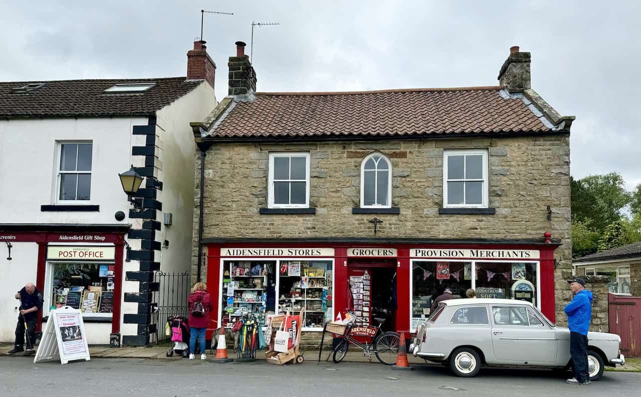
After exploring Goathland Railway Station, it’s time to head back up the road and walk through the village. As I stroll through Goathland, I encounter charming cafes and shops, such as The Village Store and Gift Centre. The village store offers a variety of fine foods, speciality jams, preserves, and a selection of wines, beers, and spirits.

A bit further up the road is Aidensfield Stores, which has a distinctive red and cream exterior. This building is well-known for its role in Heartbeat, where it featured as the village’s grocery and provision merchants. The store stocks a huge variety of memorabilia, making it a nostalgic stop for fans of the show.
At the top of the road is a green with a seat and a World War I memorial cross. For my Goathland to Grosmont walk, I turn right here, following the signpost for Beck Hole. Sheep are everywhere, as they have a common right, granted by the Duchy of Lancaster, to graze the village greens and surrounding moorland.

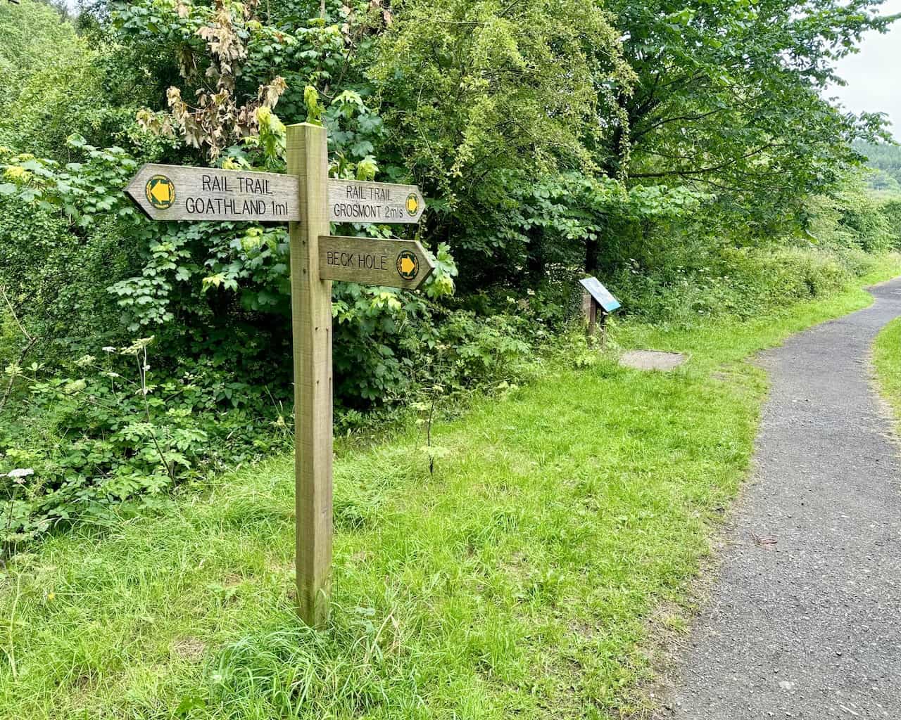
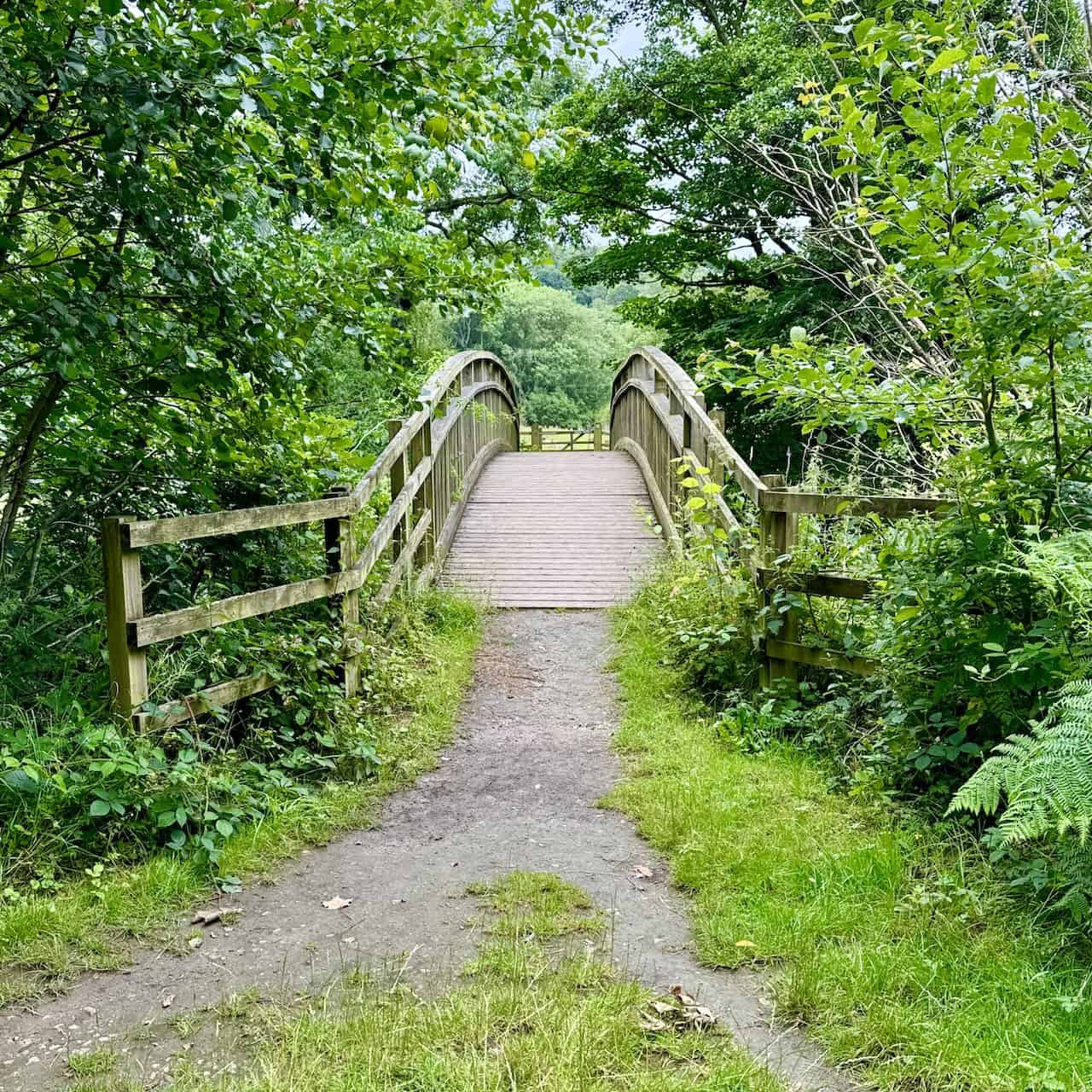
The road from the village green leads downhill. There are some flagstones by the side of the road leading down to gates at the bottom. Turn left through the gates onto the Rail Trail to Grosmont. The rest of the Goathland to Grosmont walk follows the Rail Trail, which is about three miles (4.8 kilometres) to Grosmont.

From the gates, the Rail Trail is initially downhill, then it’s mostly flat and easy-going along a nice surface, comfortable to walk on and not too strenuous. The gentle walk follows the original route of the Whitby and Pickering Railway, designed by George Stephenson. The trail leads through scenic landscapes and historical sites, with plenty to see and many places to rest along the way to soak up the atmosphere.

At the bottom of the incline, the Goathland to Grosmont route continues straight on, passing by the front of Incline Cottage.

A little further along, I come across this Beck Hole orchard by the side of the trail. A nearby sign explains that in Victorian times, Beck Hole was famous for its tea gardens and numerous apple orchards. Visitors came to Beck Hole Station, initially by horse-drawn carriage and later by steam train. In 2006, residents of Beck Hole formed a Woodland and Heritage Foundation. Its principal objectives are to preserve the ancient woodlands and natural beauty of the valley and to protect and interpret its local heritage, while encouraging wildlife, flora, and fauna for country lovers to enjoy.
In 2009, the Goathland Primary School celebrated its bicentenary. To mark the event, the foundation decided to plant an apple orchard in the valley on land provided by the Ainley family, formerly of Firs Farm. With grants from the Community Trees Fund of The Tree Council and the North York Moors National Park Village Improvement Scheme, a donation from the Goathland Post Office, and collection boxes at Birch Hall Inn, money was raised to prepare the orchard and plant 20 different varieties of heritage apple tree, each of which has been adopted by a pupil of the school.

This area, shortly after the orchard, is the original site of Beck Hole Station. An interpretation display board explains the area’s history. A signpost indicates a path to Beck Hole on the right, which is worth a detour if you want to explore the village or get a drink from the pub. However, to continue to Grosmont, proceed straight ahead, with about two miles (3.2 kilometres) left to go.
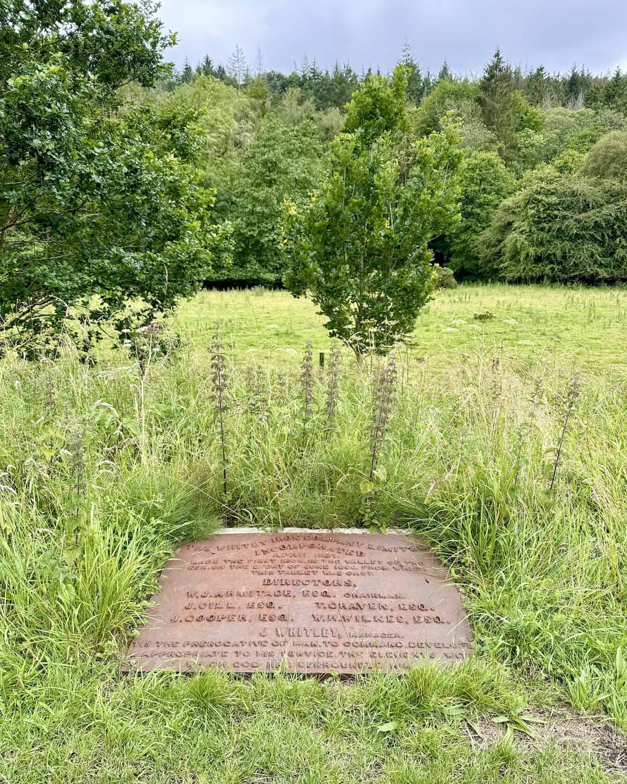
I come across this sign on the ground by the side of the path, entitled ‘The Whitby Iron Company Limited Incorporated, April 1857’. It says that the company made the first iron in the Esk Valley on 8 June 1860, and the tablet was cast from that iron. The directors were W. J. Armitage, J. Gill, T. Craven, J. Cooper, W. H. Wilkes, and the manager was J. Whitley. Below the names, the words read roughly as: ‘It is the prerogative of man to command, develop, and appropriate to his service the elements with which God has surrounded him.’
The humps and bumps in the field opposite this seat are all that’s left of the once bustling Beck Hole Ironworks. According to the Whitby Gazette on 18 June 1860, the blast furnaces here threw up ‘perpetual columns of vapour, smoke, and flame’. The ironworks were short-lived, operating only from 1860 to 1864. One of the furnaces was defective, and the mines were abandoned. The picture-frame silhouette provides an insight into what the works looked like.


Further along the Rail Trail on my Goathland to Grosmont walk, I rest at this delightful spot and enjoy a coffee from my flask. The bench depicts a Victorian couple riding along the old railway line on a coach pulled by two horses.


This is the Twin Arch Bridge, which once carried heavy steam locomotives. My walk continues straight across this bridge, but before proceeding, I take the steps down to the river to see the bridge from below. The original 1836 horse-drawn railway did not cross the bridge as it was on the other side of the river. There is now a footpath in its place. This bridge was built for the later 1847 steam railway. The current North Yorkshire Moors Railway line is higher up in the trees to the east of both these lines and is called the Deviation Line.

I reach North Bridge. Here, at the crossing of the Murk Esk river, the forces of nature and industry have often collided over the last two centuries. Despite the peaceful surroundings, glimpses of the Victorian railway age that once shaped this valley are easy to see. The Murk Esk looks dirty, but it’s not. The river catches water from large areas of moorland, resulting in its brown peaty colour. Despite this, the water quality is generally very high, making it a significant habitat for wildlife.
The original Whitby and Pickering Railway was horse-drawn, but plans to improve the service required new infrastructure. A substantial stone bridge was first built here in 1845 to enable heavier steam engines to use the line. However, the river periodically suffered damaging floods, and the stone bridge was washed away – the large stone walls are the surviving abutments of this bridge. The stone bridge was replaced by a timber railway bridge, but this too was damaged in the devastating floods of the early 1930s. By the side of the path are two massive steel-tipped, capped posts (lying horizontally) that were originally driven into the river bed to support the structure. Ultimately, water proved to be the more powerful force. The river here has only been crossed by pedestrian footbridges ever since.


This footbridge is approximately the halfway point of the Rail Trail between Goathland and Grosmont. It would have been used to carry the railway line.

This section of the walk is particularly interesting. The display board contains information about Murkside Mines, explaining the formation of ironstone and whinstone in the area. Through the gate in the photo, a small detour path leads to see peculiar heaps of disfigured black rock. This rock is ironstone, which was mined in this area many years ago. After mining, the ironstone was roasted to remove impurities and reduce its weight before transportation. However, this pile of black rock probably got too hot, resulting in an unusable lump of fused ironstone and waste.

A traditional stone cottage with a slate roof by the side of the track. I love the arched entrance to the property, with climbing roses in full bloom.

Shortly after the cottage, there is a charming wooden bridge that crosses the Murk Esk. The bridge is on the right-hand side and not part of this Goathland to Grosmont walk, but it’s a pleasant spot to stand and watch the river flowing underneath.
On my right-hand side, I pass this row of multi-coloured old railway workers’ cottages.

To the left, after the railway cottages, is a path leading to the site of the Esk Valley ironstone mine. It’s a detour from the main walk but worth a quick visit. The mine was developed in the 1860s but became overgrown and forgotten. More recently, conservation work revealed its ingenious design. There are two interpretation display boards on the site to explain all.


The Rail Trail is an easy-going route with minimal inclines and so much to see. At this point, it appears that the way is blocked by a gate. But the path leads off to the left and is signposted Rail Trail Grosmont. It’s straightforward and easy to navigate.


On the right-hand side, at the top of some steps, is a viewing area with a bench. The engine sheds and works of the North Yorkshire Moors Railway are down below, set within the lush green landscape. Locomotives hiss and blow off steam. The scene captures the juxtaposition of industrial heritage and natural beauty.

At the top of the bank, the trail emerges to a picturesque spot overlooking the village of Grosmont. Another one of those picture-frame silhouettes shows Grosmont as it was in the past. I often see people sitting on the seat enjoying the view. My Goathland to Grosmont walk takes me down the hill on the right, following the signpost for Grosmont.


Almost at the bottom of the hill, St Matthew’s Church is on the right. It was built in 1875 to the design of Armfield and Bottomley, replacing an earlier church from 1840. The building was funded largely by Charles and Thomas Bagnall, local ironmasters, and Mrs Mary Clarke, a sister of the Revd Dr William Scoresby, the Whitby navigator and polar explorer.

Isn’t this garden beautiful, celebrating 50 years of the NYMR from 1973 to 2023?

The tunnel on the left was one of the world’s first passenger railway tunnels, used by George Stephenson’s horse-drawn carriages. It is much smaller than the adjacent tunnel on the right, which is used by the railway line today. This is because the line’s tunnels and bridges had to be enlarged once steam locomotives were introduced after 1847.

As I near the railway station in Grosmont, a steam locomotive passes by. What a delightful sight.

I’ve reached Grosmont village centre. Grosmont is proud to host Britain’s oldest independent co-op, the Grosmont Co-operative Society Ltd, which has been serving the community since August 1867. Next door is Dave Edge, a shop selling model railways and buses.

These pictures are taken from the footbridge that crosses the railway line at Grosmont Station. Wonderful views from here, with plenty to see from the elevated position.


Finally, a few photos of the steam locomotive 44806, which was in Grosmont Railway Station. Steam locomotive 44806, also known as ‘Kenneth Aldcroft,’ was built at Derby in 1944. It served in various sheds across the Midland route until its withdrawal in 1968, coinciding with the end of steam on British Railways. The locomotive was preserved directly from service and became part of the ‘Steamtown’ collection at Carnforth. Over the years, it moved between several heritage railways and museums. In 2013, 44806 was acquired by the North Yorkshire Moors Railway and underwent extensive overhaul work at Grosmont, returning to service in 2016. However, in 2020, the NYMR sold it to Peter Best, who financed another overhaul to ensure its continued operation. This overhaul included significant boiler work carried out by Riley & Sons Ltd and chassis work at Grosmont.


Highly Rated Osprey Hiking Backpacks for Outdoor Enthusiasts
Osprey’s reputation for crafting high-quality hiking backpacks is well-established, offering a range of options that cater to both men and women. The following four backpacks stand out for their excellent sales and customer ratings on Amazon, making them a top choice for outdoor enthusiasts seeking reliability and comfort. As an Amazon affiliate, I may earn a small commission from any purchases made through the links provided. This helps support the upkeep of this website. Rest assured, you won’t pay a penny extra, but your purchase will contribute to keeping my site running smoothly. Happy walking!

Osprey Tempest 20 Women’s Hiking Backpack
The Tempest 20 stands out as the ideal solution for day-hiking, biking, or peak-bagging, tailored specifically for women. It features a panel-loading design for ease of access, complemented by an internal zippered mesh pocket with a key clip for secure storage. Unique to this model are the Stow-on-the-Go trekking pole and LidLock bike helmet attachments, enhancing its versatility. Side stretch mesh pockets, along with an easy-access, expandable stretch mesh harness pocket, offer ample storage. Additionally, it includes a blinker light attachment (light not included) and a large stretch mesh front panel pocket for extra carrying capacity.

Osprey Talon 22 Men’s Hiking Backpack
Designed for the active adventurer, the Talon 22 provides an optimal panel-loading design suitable for day-hiking, biking, or peak-bagging. Key features include dual-zippered panel access to the main compartment and a tuck-away ice ax attachment with a bungee tie-off. It boasts a top panel zippered slash pocket for quick access items and lower side compression straps for load management. An external hydration reservoir sleeve and dual-zippered fabric hipbelt pockets enhance hydration and storage, while a large stretch mesh front panel pocket increases its utility for various activities.

Osprey Tempest 30 Women’s Hiking Backpack
The Tempest 30, designed with a women’s-specific fit, is a streamlined top-loader ideal for both extensive day trips and light-and-fast overnight adventures. It includes a fixed top lid with an external zippered slash pocket and an under-lid zippered mesh pocket with a key clip for organised storage. The pack features a tuck-away ice ax attachment with a bungee tie-off, dual upper and lower side compression straps for load adjustment, and an external hydration reservoir sleeve. For added convenience, it offers an easy-access, expandable stretch mesh harness pocket and dual-zippered fabric hip-belt pockets.

Osprey Talon 33 Men’s Hiking Backpack
The Talon 33 is engineered for dynamic movement, making it the perfect streamlined top-loader for committed day trips or light-and-fast overnight excursions. It features top load access to the main compartment for easy packing and retrieval. The backpack is equipped with a large stretch mesh front panel pocket, Stow-on-the-Go trekking pole attachment, and stretch mesh side pockets for versatile storage options. Additionally, an easy-access, expandable stretch mesh harness pocket and dual-zippered fabric hip-belt pockets offer convenient storage solutions for essential gear.