Visit Levisham on the Hole of Horcum Circular Walk in the North York Moors
Your Hole of Horcum circular walk begins at the North York Moors National Park car park at Saltergate. The car park is situated beside the A169 Whitby to Pickering road, just at the top of Saltergate Brow. Leave the car park and cross the road. Opposite the car park’s north entrance, you’ll see a set of steps descending to a footpath. Turn right and walk along the footpath, immediately enjoying spectacular views of the Hole of Horcum.
Continue along the path until you reach the main road on your right, then proceed straight ahead along the stone track. A sign on your left will welcome you to Levisham Moor. Walk directly through the gate, avoiding the path to the left which descends into the Hole of Horcum—you’ll return that way later. After the gate, head slightly uphill, following the trail onto the heather moorland. This route is part of the Tabular Hills Walk. Keep heading west, then south-west across Levisham Moor.

The well-defined path initially circles the upper rim of the Hole of Horcum before leaving the impressive crater behind you. After hiking for over two miles (3.2 kilometres) on the Tabular Hills Walk across the moorland, you will reach a crossroads at Dundale Rigg with multiple paths to choose from. Thankfully, there is a signpost! Follow the route marked Levisham (Tabular Hills Walk) slightly uphill along a grassy trail. At the top, you’ll reach a gate and signpost pointing towards Newton upon Rawcliffe.
The track becomes a narrow tarmac lane called Limpsey Gate Lane, leading directly to the village of Levisham. Upon reaching the village, you’ll pass the Horseshoe Inn on your right. Walk south along the road straight through the village to its other end. As you reach the point where the road leaves the village and bends to the right downhill, look out for a path on your left into the trees. At the signpost, turn left, following the North York Moors public footpath, not the one downhill which follows the Tabular Hills Walk.

The narrow woodland path leads you east above the valley, with the valley sloping down on your right. Take care to follow the sign to Horcum and not down to Lockton. Eventually, the woodland path will head from east to north through Levisham Brow, although you may not notice the change in direction. After nearly one and a half miles (2.4 kilometres) of walking through the woodland path from Levisham, you’ll emerge from the trees and descend through a gate to reach a grassy open area where there is a junction. A signpost indicates that turning left leads you to Dundale Pond, but that is not the route you will take today.
Continue forward towards the Hole of Horcum, following the path along the side of a dry stone wall through the trees. The path is easy to follow and continues north through Horcum Slack. The valley widens, and your trail crosses a beautiful area of open grassland, leading you through the Horcum Slack valley into the Hole of Horcum itself. You will reach Low Horcum at the bottom of the huge natural basin and pass by the left-hand side of a wall-enclosed derelict barn.
After the barn, keep going straight ahead. Take care not to turn right through a gate which seems to be the natural way to go but is not. Instead, continue straight ahead and descend slightly to go through another gate which will lead you to a distinct stone path. The stone path will lead you north-east, ascending and eventually exiting the Hole of Horcum. You’ll return to the path by the side of the A169 where you were earlier in the day. Follow the narrow path back to the Saltergate car park, which will conclude your Hole of Horcum circular walk. If you’re lucky, you may find an ice cream van parked in the car park, usually in the summer months.
Hole of Horcum Circular Walk: Maps and Tools
Visit either the OS Maps website or the Outdooractive website to view this walking route in greater detail. Both platforms offer a range of features, including the ability to print the route, download it to your device, and export the route as a GPX file. You can also watch a 3D fly-over and share the route on social media.
Hole of Horcum Circular Walk: Distance, Duration, Statistics
Distance: 7 miles
Distance: 11¼ kilometres
Duration: 3½ hours
Ascent: 901 feet
Ascent: 275 metres
Type: Circular walk

Recommended Ordnance Survey Map
The best map to use on this walk is the Ordnance Survey map of the North York Moors Eastern Area, reference OS Explorer OL27, scale 1:25,000. It clearly displays footpaths, rights of way, open access land and vegetation on the ground, making it ideal for walking, running and hiking. The map can be purchased from Amazon in either a standard, paper version or a weatherproof, laminated version, as shown below.
About the Hole of Horcum
My Hole of Horcum circular walk begins at the North York Moors National Park car park at Saltergate. Located beside the A169 Whitby to Pickering road, right at the top of Saltergate Brow, this car park serves as an ideal starting point for your adventure. Stepping out of your vehicle, you will notice a traditional dry stone wall surrounding some paving stones. Carved into these stones is an inspiring inscription:
Ancient remains, a haven for nature,
a land of myth and giants.
Set out and discover the beauty and tranquility of the
HOLE OF HORCUM
and LEVISHAM MOOR.
Walk among a vast, natural amphitheatre
of moorland, grassland and woodland.
A place forged over thousands of years by water and frost,
a place protected for nature.
Go further and the ground whispers
clues of ancient human past.
THE LAND IS CALLING,
you only have to look and listen.
These words perfectly capture the essence of what lies ahead. The Hole of Horcum, with its expansive moorland, grassland, and woodland, presents a unique and tranquil natural amphitheatre.
The Hole of Horcum is part of the valley of the Levisham Beck, located upstream of Levisham and Lockton, within the Tabular Hills of the North York Moors National Park.
Historical Roots
The name has evolved over time, with early forms including Hotcumbe, Holcumbe, Horcombe, and Horkome. The first part, ‘horh,’ is Old English for ‘filth,’ while ‘cumb,’ meaning ‘bowl-shaped valley,’ is of Brittonic Celtic origin.
Natural Sculpting
The hollow is 400 feet (120 metres) deep and approximately ¾ mile (1.2 kilometres) across. It was created by a process known as spring-sapping, where water seeping from the hillside gradually erodes the slopes, wearing the rocks away grain by grain. Over thousands of years, this process has transformed a narrow valley into an enormous cauldron. The process continues today.
Legendary Tales
According to local legend, this amphitheatre, often referred to as the ‘Devil’s Punchbowl,’ was formed when Wade the Giant scooped up a handful of earth to throw at his wife, Bell, during an argument. The clump of earth supposedly landed and formed the nearby hill of Blakey Topping. This enchanting tale adds a mythical layer to the geological wonder.
The Hole of Horcum Circular Walk
Embark on my Hole of Horcum circular walk, which guides you through this captivating landscape, blending natural beauty with rich folklore. As you meander through the moorland, enjoy the vast views and envision the legendary giant’s quarrel that, according to myth, shaped the countryside. While there are many routes in and around the area, the walk described here is a 7-mile (11.5-kilometre) route offering spectacular views and a chance to explore the unique flora and fauna of the North York Moors.
Hole of Horcum Circular Walk: My Photos
Almost immediately after leaving the car park at the start of my Hole of Horcum circular walk, I enjoy spectacular views down into the vast natural basin.


Shortly after joining the Tabular Hills Walk above the steep northern slopes, the view of the Hole of Horcum comes into focus.

This shot captures the scenery from the Tabular Hills Walk on the northern side of the Hole of Horcum, looking back towards the car park.

From the Tabular Hills Walk, the view looking south into the Hole of Horcum reveals a dramatic hollow. I can see the barn at Low Horcum, encircled by a dry stone wall, which I’ll pass on my return.

The Tabular Hills Walk skirts around the northern and western upper rim of the Hole of Horcum. The bridleway crosses Levisham Moor, bordered by heather moorland. It’s a stone track, partially covered with grass, making it relatively flat and easy to walk along.

Highland cattle, with their distinctive long horns and shaggy coats, rest beside the track near Dundale Rigg.

After about two and a half miles on the Tabular Hills Walk, I reach a crossroads at Dundale Rigg. There are five options:
- Return to where you came from, signposted Saltergate, if you’ve had enough!
- Turn right, signposted Levisham Station. This path leads to the station or to Skelton Tower, which offers impressive views of the North Yorkshire Moors Railway line running through a beautiful valley.
- Continue straight, signposted Braygate Lane (Levisham), an alternate route into the village.
- Turn left, signposted Levisham, which is the route I’m taking into the village via Limpsey Gate Lane.
- Alternatively, turn left and then downhill, signposted Dundale Griff to Hole of Horcum. This shortcut avoids the longer Levisham and Levisham Brow route.


Following the Tabular Hills Walk along Limpsey Gate Lane, I enter the village of Levisham.

The Horseshoe Inn in Levisham is a charming 19th-century inn offering both restaurant and accommodation.

St John the Baptist Church in Levisham village is a nineteenth-century building that replaced the Church of St Mary the Virgin. The latter, now a ruin, is situated in the valley between Lockton and Levisham. It became the Parish Church of Levisham in the 1950s when St Mary’s ceased to be used.

Continuing my Hole of Horcum circular walk through the picturesque North Yorkshire village of Levisham, I pass traditional stone cottages with neatly kept lawns on either side of the road. This view is looking down the road from north to south.

Levisham village hall is a great place to stop for a break or lunch on the bench. The red phone box now houses a defibrillator and a selection of books.

Here’s another view of Levisham village, this time looking back from south to north towards the Horseshoe Inn at the top.

After walking through Levisham, I come across a small path to the left where the road bends downhill to the right. I take a left at the signpost marked by the yellow public footpath arrow, avoiding the downward route marked as the Tabular Hills Walk.

This narrow woodland path heads east shortly after leaving the village.

Continuing along the woodland path, a signpost directs me to Horcum, avoiding the downhill path to Lockton.

As I wander along the path, occasional views south across the valley to Lockton appear, visible behind the trees on the opposite hillside.

This footpath heads north through the woods of Levisham Brow. It’s not difficult, but in summer it can become a bit overgrown, and in winter, a bit muddy. There are some small ups and downs, sometimes with steps, but overall it’s a very engaging section of my Hole of Horcum circular walk.

After a while walking along Levisham Brow, I emerge from the woods, and the valley leading back to the Hole of Horcum starts to become visible in the distance.

The path from Levisham Brow leads downhill through a gate to a lovely grassy area near a stream, often used by people for picnics. I come across a sign which directs me straight on to the Hole of Horcum.

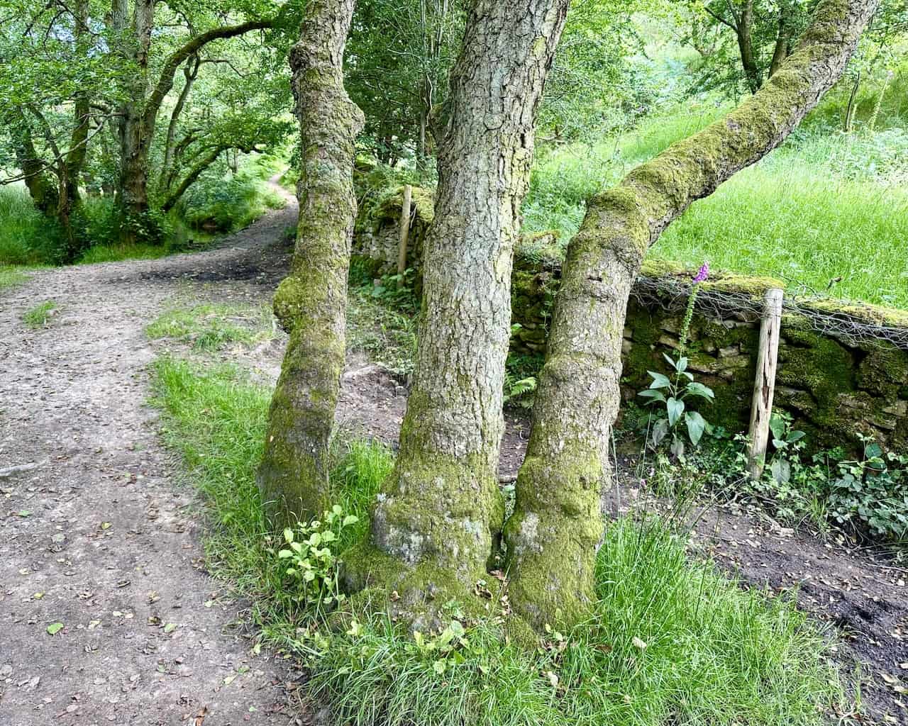
From the picnic area, my path continues north along the side of a moss-covered dry stone wall. Three trees seem to point the way.
This is a delightful section of the Hole of Horcum circular walk, with the path through the valley on the way to Horcum Slack. In summer, it’s green and lush, with small trees and high bracken lining the path.

Soon, I see the widening valley over the treetops, leading to the Hole of Horcum.

Sheep graze in the meadowland of Horcum Slack, and ahead are the north-western slopes of the Hole of Horcum.

These are the north-western slopes of the enormous crater in the landscape as I walk through Low Horcum.

At the beginning of my photo descriptions, I mentioned I could see the Low Horcum barn surrounded by a dry stone wall. Now, I am passing it a couple of hours later.


Soon after the barn, the route drops down to a gate, after which is a well-defined stone path leading up out of the hollow.

This is a tiring part of my Hole of Horcum circular walk as the stone track leads uphill out of the dramatic basin.

Looking east, I see the spot where I’m parked at the top of the tree-covered west-facing slopes of the bowl. It’s the end of July, and the heather is beginning to take on its distinctive purple appearance.

I emerge from the Hole of Horcum at a point which overlooks the bend in the road of the A169. In this view, the road leads north. On the horizon, I can see the pyramidal shape of the radar station at RAF Fylingdales. This pyramid design replaced the older ‘golf balls’ I remember from my childhood.

One final look at the enormous depression at the end of my Hole of Horcum circular walk. It’s been a blast! Enjoy it.

Amazon’s Top Walking Boots: Four Standout Choices for Men and Women
For walking and hiking, the right boots are essential for both comfort and safety. While Amazon boasts a wide range, certain boots emerge as top-sellers. From those, here are four I personally favour. As an Amazon affiliate, I may earn a small commission from any purchases made through the links provided. This helps support the upkeep of this website. Rest assured, you won’t pay a penny extra, but your purchase will contribute to keeping my site running smoothly. Happy walking!

Berghaus Men’s Hillmaster II Gore-Tex Walking Boots
These fully waterproof leather walking boots feature a Gore-Tex lining, ensuring no water enters whilst allowing feet to breathe and stay cool. Made from full-grain leather, they promise unmatched durability and comfort. The boots come with memory foam tongues and cuffs that mould to your feet for a tailored fit, and the Vibram Hillmaster outsoles offer confidence on challenging terrains.

Salewa Men’s Mountain Trainer Mid Gore-Tex Walking Boots
Made from durable suede and abrasion-resistant textile, these men’s hiking boots are both lightweight and sturdy. The upper material is enhanced by a 360° full rubber sheath. Their dual-layer midsole with Bilight technology ensures ergonomic cushioning and grip, especially on extended hikes. The Vibram Wrapping Thread Combi outsoles allow a natural walking feel, and the Gore-Tex lining provides waterproofing, breathability, and optimal weather protection. Furthermore, the patented Salewa 3F system ensures flexibility, a secure heel grip, and a blister-free fit.

Berghaus Women’s Supalite II Gore-Tex Walking Boots
Specially designed for women, these hiking boots offer waterproofing and breathability, thanks to their Gore-Tex lining. Crafted from full-grain abrasion-resistant leather, they’re durable enough for the toughest hikes. The Supalite soles ensure stability and traction, and the EVA midsoles add comfort for extended walks.

Merrell Women’s Moab 3 Mid Gore-Tex Walking Boots
These hiking boots incorporate a Gore-Tex waterproof membrane, blending breathability with superior waterproof performance. The combination of pigskin leather and mesh on the uppers, along with the suede outer material, ensure durability and style. Enhancements include 100% recycled laces, webbing, and mesh lining. Additionally, bellows tongues, protective toe caps, and Vibram TC5+ rubber soles ensure protection and ease on any terrain.