Richmond and Applegarth
West from Richmond to Applegarth via Whitecliffe Wood, then back along the valley following the course of the River Swale. South-east to Easby Abbey, followed by a look around Richmond town centre and a visit to the castle. A 9-mile walk in Northern England.
Recommended Ordnance Survey Map
The best map to use on this walk is the Ordnance Survey map of Darlington & Richmond, reference OS Explorer 304, scale 1:25,000. It clearly displays footpaths, rights of way, open access land and vegetation on the ground, making it ideal for walking, running and hiking. The map can be purchased from Amazon in either a standard, paper version or a weatherproof, laminated version, as shown below.
My Photos
The view south-east towards Richmond from Westfields, near Whitcliffe Farm. A plaque nearby recites a paragraph from the book ‘A Coast to Coast Walk’ by Alfred Wainwright (1907-1991):
There is a thrilling view of Richmond ahead. Richmond is a town unlike others, a place unique, rich in relics of the past, steeped in a long history that still lingers in the ramifications of its castle and the narrow alleys and quaint buildings that huddle in the shelter of the massive Norman keep. The castle, dramatically poised on a cliff high above the Swale, is a dominating feature. It is a town of reminders of times long past. It is too good to be by-passed.
To be honest, the view isn’t all that good in my opinion.

The view south from High Leases to the village of Hudswell on the other side of the River Swale.

Swaleview Caravan Park nestled between Hag Wood and the River Swale.


Walking in the Yorkshire Dales with 43 Circular Routes
AD This Cicerone guidebook includes 43 circular walks exploring valleys, hills, and moors between Kirkby Stephen and Pateley Bridge. With OS maps, local highlights, and routes ranging from 3–11 miles, it is a year-round companion for walkers of all abilities.
Time for a quick photo on the bridleway near East Applegarth.


Grisport Unisex Adult Peaklander Hiking Boots
AD The Grisport Unisex Adult Peaklander Hiking Boots are crafted in Italy with a durable waxed leather upper, Spotex breathable lining, and a reliable Track-on rubber sole. Waterproof and weighing just 1120g, they offer comfort, resilience, and dependable performance on demanding trails.
The meandering River Swale in the valley below.

The River Swale.

Grisport Unisex Adult Peaklander Hiking Boots
AD The Grisport Unisex Adult Peaklander Hiking Boots are crafted in Italy with a durable waxed leather upper, Spotex breathable lining, and a reliable Track-on rubber sole. Waterproof and weighing just 1120g, they offer comfort, resilience, and dependable performance on demanding trails.
The River Swale as seen from the footbridge near Hudswell Woods.

The view east from the banks of the River Swale, with the keep of Richmond Castle visible above the trees.


Fifty Walks Across the Beautiful North York Moors National Park
AD Discover 50 routes across the North York Moors, from short easy strolls to challenging high-level hikes. With OS maps, route descriptions, and local highlights, it also includes the legendary 40-mile Lyke Wake Walk, described in four accessible stages.
The River Swale and Richmond Castle.

The River Swale waterfalls in Richmond town centre.

Fifty Walks Across the Beautiful North York Moors National Park
AD Discover 50 routes across the North York Moors, from short easy strolls to challenging high-level hikes. With OS maps, route descriptions, and local highlights, it also includes the legendary 40-mile Lyke Wake Walk, described in four accessible stages.


Osprey Hikelite Unisex Backpack for Comfortable and Lightweight Hiking
AD The Osprey Hikelite backpack combines lightweight design with practical features, including a breathable mesh back panel, soft webbing straps, and stretch mesh water bottle pockets. With zipped storage and an organiser compartment, it is ideal for day hikes and outdoor use.

Mercury Bridge, Richmond.


Peak Bagging Wainwrights with Routes to Complete All Fells
AD This comprehensive guide offers 45 circular routes linking all 214 Wainwright fells. With maps, GPX downloads, elevation profiles, and practical advice, it provides efficient yet inspiring ways to complete this classic Lake District challenge at your own pace.
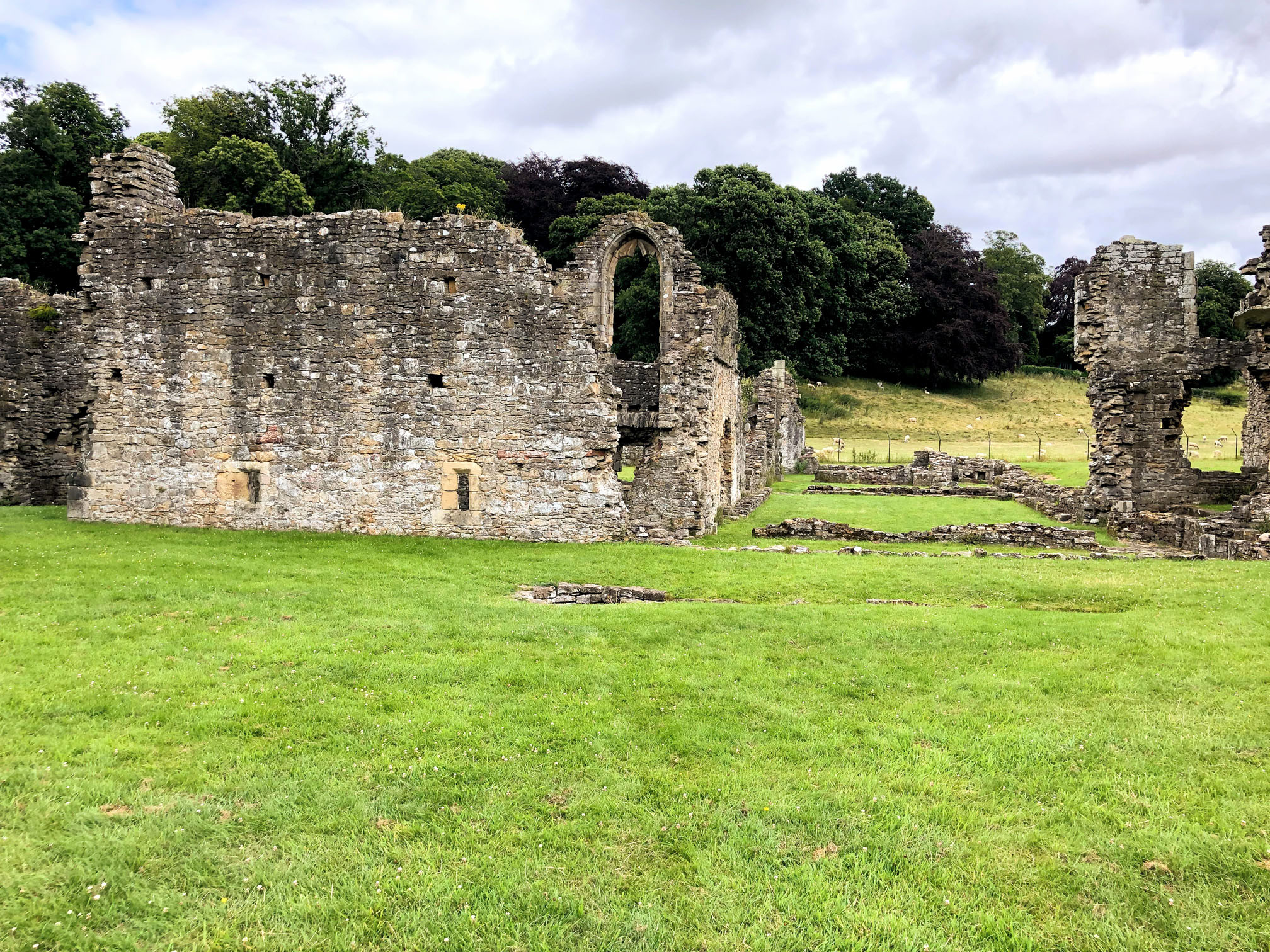
Easby Abbey, founded in 1151-1152 by Roald, constable of Richmond Castle.


Peak Bagging Wainwrights with Routes to Complete All Fells
AD This comprehensive guide offers 45 circular routes linking all 214 Wainwright fells. With maps, GPX downloads, elevation profiles, and practical advice, it provides efficient yet inspiring ways to complete this classic Lake District challenge at your own pace.


Berghaus Hillmaster II GTX Men's High Rise Hiking Boots
AD The Berghaus Hillmaster II GTX men’s hiking boots feature a waterproof, breathable GORE-TEX membrane, a memory foam tongue and collar for a personalised fit, and a Vibram sole delivering exceptional grip, stability, and shock protection for confident performance on any terrain.
A reconstruction of Easby Abbey at the time of its suppression circa 1537. Painting by Terry Ball.

The refectory at Easby Abbey.

Berghaus Hillmaster II GTX Men's High Rise Hiking Boots
AD The Berghaus Hillmaster II GTX men’s hiking boots feature a waterproof, breathable GORE-TEX membrane, a memory foam tongue and collar for a personalised fit, and a Vibram sole delivering exceptional grip, stability, and shock protection for confident performance on any terrain.
A reconstruction of the refectory at Easby Abbey. Painting by Jill Atherton.

The cloister at Easby Abbey.


Kendal Mint Co Energy Gel with Citrus and Mint Flavour
AD Kendal Mint Co energy gels deliver 27g of fast-absorbing carbohydrates plus electrolytes and B vitamins for improved performance. Vegan, gluten free, and Informed Sport certified, these caffeine-free gels are refreshing, easy to digest, and ideal for running, cycling, and endurance.

Remains of the abbey church at Easby.

Kendal Mint Co Energy Gel with Citrus and Mint Flavour
AD Kendal Mint Co energy gels deliver 27g of fast-absorbing carbohydrates plus electrolytes and B vitamins for improved performance. Vegan, gluten free, and Informed Sport certified, these caffeine-free gels are refreshing, easy to digest, and ideal for running, cycling, and endurance.
A reconstruction of the abbey church at Easby in the later Middle Ages. Painting by Jill Atherton.

Additional buildings to the north of the abbey church would have included the abbey infirmary, the infirmary kitchen, and other chambers and latrines.


Thermos Stainless King Flask for Travel and Daily Adventures
AD The Thermos Stainless King 470ml flask keeps drinks hot for 18 hours or cold for 24. With durable stainless steel, vacuum insulation, a serving cup, and a leakproof design, it is perfect for commutes, journeys, and outdoor adventures.

Thermos Stainless King Flask for Travel and Daily Adventures
AD The Thermos Stainless King 470ml flask keeps drinks hot for 18 hours or cold for 24. With durable stainless steel, vacuum insulation, a serving cup, and a leakproof design, it is perfect for commutes, journeys, and outdoor adventures.
St Agatha’s Church, Easby.

The gatehouse at Easby Abbey.

Lake District High Level and Fell Walks with Thirty Routes
AD This pocket-sized guide presents 30 routes on the Lake District’s highest fells, including Scafell Pike, Helvellyn, and Blencathra. With OS maps, colour photographs, and practical notes, it offers circular walks from 4–15 miles graded by difficulty.
Farmland around Easby Abbey.

Painting on the side of a building in Richmond town centre. Some of the town’s attractions are named on the signpost.

Lake District High Level and Fell Walks with Thirty Routes
AD This pocket-sized guide presents 30 routes on the Lake District’s highest fells, including Scafell Pike, Helvellyn, and Blencathra. With OS maps, colour photographs, and practical notes, it offers circular walks from 4–15 miles graded by difficulty.
Amazing 360° views from the top of the Richmond Castle keep.


Super Sparrow Stainless Steel Insulated Water Bottle with Two Lids
AD The Super Sparrow stainless steel water bottle keeps drinks cold for 12 hours or hot for several. With a straw lid, bamboo cap, BPA-free construction, and durable 18/8 steel, it is ideal for sport, travel, work, and outdoor use.


Super Sparrow Stainless Steel Insulated Water Bottle with Two Lids
AD The Super Sparrow stainless steel water bottle keeps drinks cold for 12 hours or hot for several. With a straw lid, bamboo cap, BPA-free construction, and durable 18/8 steel, it is ideal for sport, travel, work, and outdoor use.


Mountain Warehouse Merino Womens Long Sleeve V Neck Top
AD This Mountain Warehouse Merino top combines warmth, comfort, and practicality. Made with high-quality wool, it is naturally antibacterial, lightweight, and easy to pack. Designed for outdoor activities, it keeps you fresh and warm, and comes with a two-year warranty.

The view of the River Swale from the castle wall path.

The Coast to Coast Walk Map Booklet with OS Mapping
AD This handy map booklet covers the full 188-mile Coast to Coast route from St Bees to Robin Hood’s Bay. Featuring 1:25,000 OS maps, it is pocket-sized, practical, and designed for use in either direction across England’s landscapes.
Path around the outside of the Richmond Castle curtain wall.


The Coast to Coast Walk Map Booklet with OS Mapping
AD This handy map booklet covers the full 188-mile Coast to Coast route from St Bees to Robin Hood’s Bay. Featuring 1:25,000 OS maps, it is pocket-sized, practical, and designed for use in either direction across England’s landscapes.