Hebden and Trollers Gill
East out of Hebden along the B6265 to Bank Top, then north on Backstone Edge Lane (Track) across Hebden Moor to Knots Top. South-east to Grimwith Reservoir, continuing across its dam and around its southern perimeter to High Shaws Lathe. South-east to cross the B6265 road near Dry Gill and generally south-west on tracks and paths to Trollers Gill, before following the course of Skyreholme Beck to Middle Skyreholme. Up to High Skyreholme then south-west along Howgill Lane to Howgill, completing the walk by following the Dales Way alongside the River Wharfe via Burnsall and the Hebden Suspension Bridge. A 14-mile walk in the Yorkshire Dales.
Recommended Ordnance Survey Map
The best map to use on this walk is the Ordnance Survey map of the Yorkshire Dales Southern & Western Area, reference OS Explorer OL2, scale 1:25,000. It clearly displays footpaths, rights of way, open access land and vegetation on the ground, making it ideal for walking, running and hiking. The map can be purchased from Amazon in either a standard, paper version or a weatherproof, laminated version, as shown below.
Standard Version
My Photos
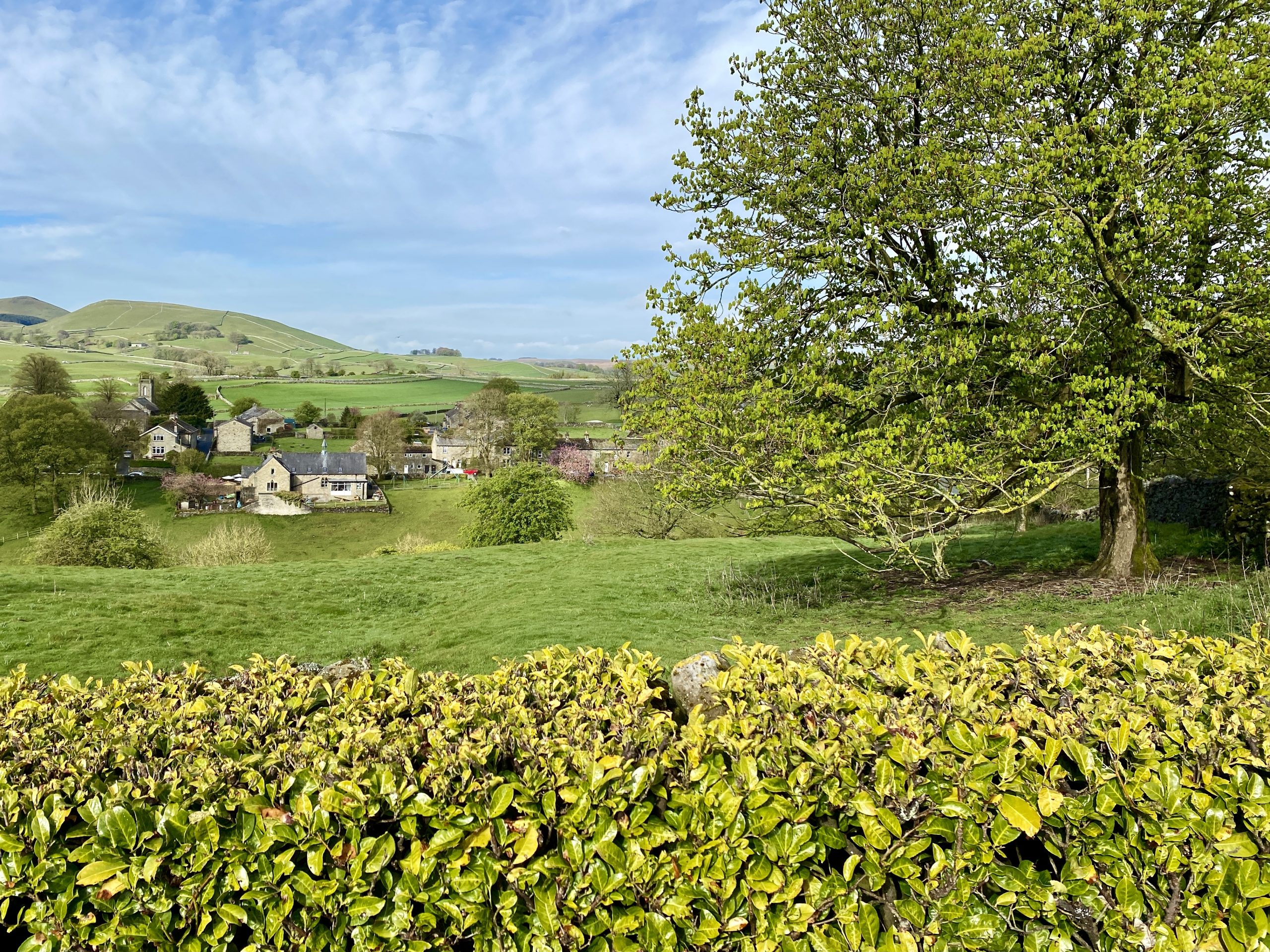
Looking back towards Hebden from the B6265.
The view south from the B6265 to the crags of Burnsall & Thorpe Fell.

Backstone Edge Lane (Track) across Hebden Moor.


Walking in the Yorkshire Dales with 43 Circular Routes
AD This Cicerone guidebook includes 43 circular walks exploring valleys, hills, and moors between Kirkby Stephen and Pateley Bridge. With OS maps, local highlights, and routes ranging from 3–11 miles, it is a year-round companion for walkers of all abilities.
Grimwith Reservoir as seen from Knots Top.


Grisport Unisex Adult Peaklander Hiking Boots
AD The Grisport Unisex Adult Peaklander Hiking Boots are crafted in Italy with a durable waxed leather upper, Spotex breathable lining, and a reliable Track-on rubber sole. Waterproof and weighing just 1120g, they offer comfort, resilience, and dependable performance on demanding trails.
Hartlington Moor Lane to the west of Grimwith Reservoir.


Grisport Unisex Adult Peaklander Hiking Boots
AD The Grisport Unisex Adult Peaklander Hiking Boots are crafted in Italy with a durable waxed leather upper, Spotex breathable lining, and a reliable Track-on rubber sole. Waterproof and weighing just 1120g, they offer comfort, resilience, and dependable performance on demanding trails.
A footpath around Grimwith Reservoir makes a lovely 4-mile circular stroll. The reservoir has a large car park which can be easily reached from the B6265 about 2½ miles east of Hebden.


Fifty Walks Across the Beautiful North York Moors National Park
AD Discover 50 routes across the North York Moors, from short easy strolls to challenging high-level hikes. With OS maps, route descriptions, and local highlights, it also includes the legendary 40-mile Lyke Wake Walk, described in four accessible stages.
Collapsed dry stone wall near Three Mires.

The Grimwith Reservoir dam.

Fifty Walks Across the Beautiful North York Moors National Park
AD Discover 50 routes across the North York Moors, from short easy strolls to challenging high-level hikes. With OS maps, route descriptions, and local highlights, it also includes the legendary 40-mile Lyke Wake Walk, described in four accessible stages.
Grimwith Reservoir valve tower.


Osprey Hikelite Unisex Backpack for Comfortable and Lightweight Hiking
AD The Osprey Hikelite backpack combines lightweight design with practical features, including a breathable mesh back panel, soft webbing straps, and stretch mesh water bottle pockets. With zipped storage and an organiser compartment, it is ideal for day hikes and outdoor use.
The view north-west across Grimwith Reservoir from the path below Grimwith Fell.

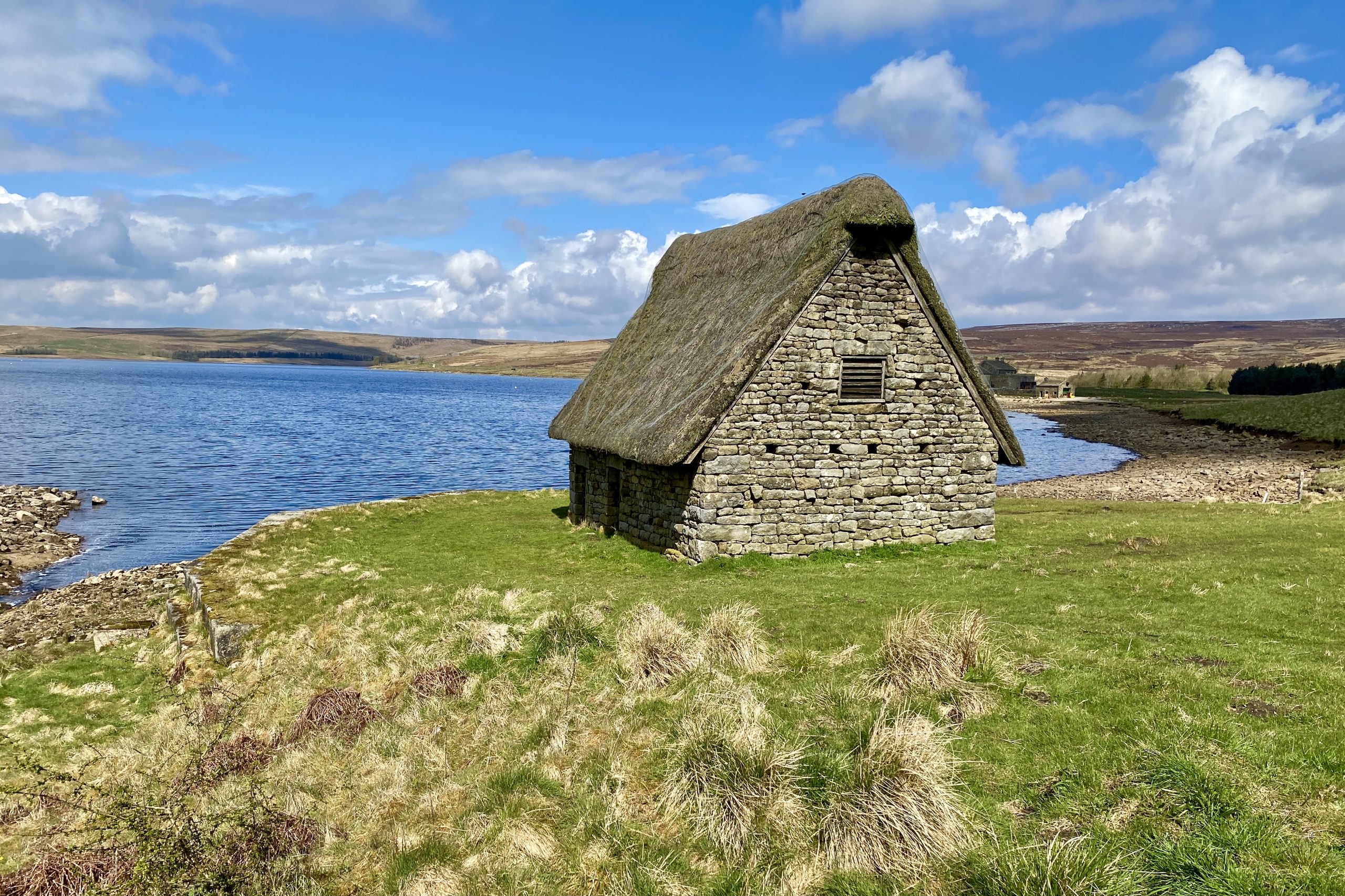
Grimwith High Laithe
The word ‘Laithe’ comes from the Viking name for barn. There are other barns in the Grimwith Reservoir area but this one is quite different, with its steep pitched roof and heather thatch.
In the 1970s when the reservoir was expanded to its current size, historians recognised that this barn was an important example of a cruck barn and it was preserved. In medieval times all barns in the Yorkshire Dales would have been built using huge A-shaped frames called crucks. The walls would have been infilled with wood or rubble and the roofs would have been thatched with straw or heather.

Osprey Hikelite Unisex Backpack for Comfortable and Lightweight Hiking
AD The Osprey Hikelite backpack combines lightweight design with practical features, including a breathable mesh back panel, soft webbing straps, and stretch mesh water bottle pockets. With zipped storage and an organiser compartment, it is ideal for day hikes and outdoor use.
By the 17th century the big trees needed to make the crucks had become scarce so as the wooden cruck barns began to rot they were gradually replaced by the stone-walled and roofed ones we see today.
High Laithe may date to the very end of the period when cruck barns were still being built so it is probably about 400 years old.
Black Hill Road near Dry Gill.


Peak Bagging Wainwrights with Routes to Complete All Fells
AD This comprehensive guide offers 45 circular routes linking all 214 Wainwright fells. With maps, GPX downloads, elevation profiles, and practical advice, it provides efficient yet inspiring ways to complete this classic Lake District challenge at your own pace.
Dry Gill.

Evidence of lead mining near Gill Heads with levels (horizontal tunnels used to gain access to the lead veins deeper in the hillside) and spoil heaps (the waste material discarded during the mining process).

Peak Bagging Wainwrights with Routes to Complete All Fells
AD This comprehensive guide offers 45 circular routes linking all 214 Wainwright fells. With maps, GPX downloads, elevation profiles, and practical advice, it provides efficient yet inspiring ways to complete this classic Lake District challenge at your own pace.

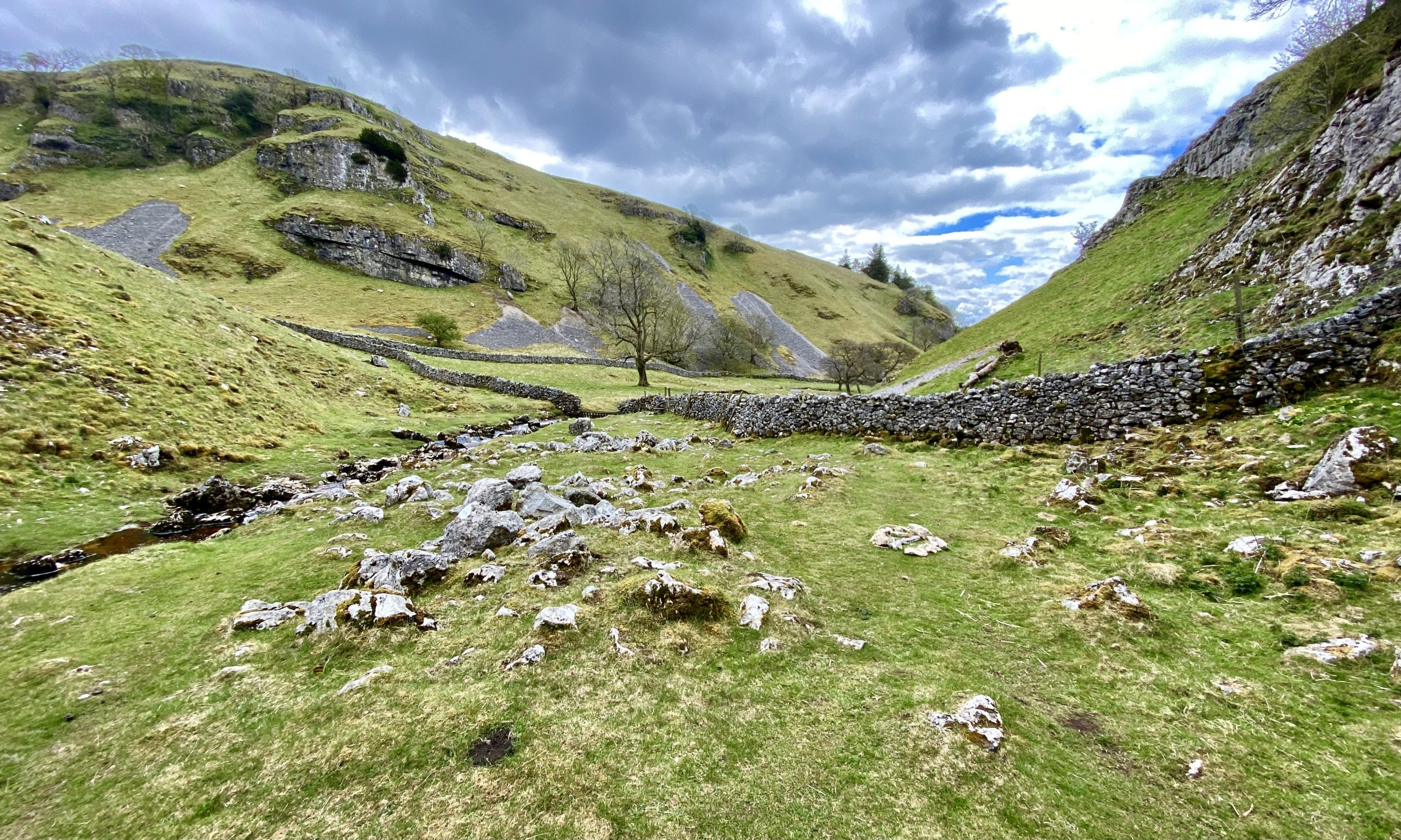
Dry Gill before it reaches the Trollers Gill gorge and becomes Skyreholme Beck.


Berghaus Hillmaster II GTX Men's High Rise Hiking Boots
AD The Berghaus Hillmaster II GTX men’s hiking boots feature a waterproof, breathable GORE-TEX membrane, a memory foam tongue and collar for a personalised fit, and a Vibram sole delivering exceptional grip, stability, and shock protection for confident performance on any terrain.

The Trollers Gill limestone gorge has been cut into the landscape by Dry Gill / Skyreholme Beck over thousands of years. The gill is about half a mile long and is named after the supposed existence of trolls who used to live there.

Berghaus Hillmaster II GTX Men's High Rise Hiking Boots
AD The Berghaus Hillmaster II GTX men’s hiking boots feature a waterproof, breathable GORE-TEX membrane, a memory foam tongue and collar for a personalised fit, and a Vibram sole delivering exceptional grip, stability, and shock protection for confident performance on any terrain.
The Skyreholme Beck valley.


Kendal Mint Co Energy Gel with Citrus and Mint Flavour
AD Kendal Mint Co energy gels deliver 27g of fast-absorbing carbohydrates plus electrolytes and B vitamins for improved performance. Vegan, gluten free, and Informed Sport certified, these caffeine-free gels are refreshing, easy to digest, and ideal for running, cycling, and endurance.
The path from the Skyreholme Beck valley to Middle Skyreholme. The rocky outcrop of Simon’s Seat can be seen in the distance on Barden Fell.

The public footpath runs through a farm at High Skyreholme, and you feel as though you are trespassing on private property.

Kendal Mint Co Energy Gel with Citrus and Mint Flavour
AD Kendal Mint Co energy gels deliver 27g of fast-absorbing carbohydrates plus electrolytes and B vitamins for improved performance. Vegan, gluten free, and Informed Sport certified, these caffeine-free gels are refreshing, easy to digest, and ideal for running, cycling, and endurance.

Howgill Lane.


Thermos Stainless King Flask for Travel and Daily Adventures
AD The Thermos Stainless King 470ml flask keeps drinks hot for 18 hours or cold for 24. With durable stainless steel, vacuum insulation, a serving cup, and a leakproof design, it is perfect for commutes, journeys, and outdoor adventures.
Howgill Barn on Howgill Lane. Accommodation established in 2020.

A beautiful purple carpet of flowering bluebells in woodland just west of Howgill.

Thermos Stainless King Flask for Travel and Daily Adventures
AD The Thermos Stainless King 470ml flask keeps drinks hot for 18 hours or cold for 24. With durable stainless steel, vacuum insulation, a serving cup, and a leakproof design, it is perfect for commutes, journeys, and outdoor adventures.
Rapids on the River Wharfe visible from the Dales Way footpath south of Appletreewick.

The River Wharfe near Burnsall.

Lake District High Level and Fell Walks with Thirty Routes
AD This pocket-sized guide presents 30 routes on the Lake District’s highest fells, including Scafell Pike, Helvellyn, and Blencathra. With OS maps, colour photographs, and practical notes, it offers circular walks from 4–15 miles graded by difficulty.
Burnsall Bridge
The original stone bridge was built in 1609 thanks to a gift of money from local benefactor Sir William Craven who also paid for Burnsall Grammar School. In 1752 it was described as being ‘a good bridge and all paved’. It was restored or possibly rebuilt in 1884 following flood damage. It has three main arches and two smaller ones.

The River Wharfe between Burnsall and the Hebden Suspension Bridge.

Lake District High Level and Fell Walks with Thirty Routes
AD This pocket-sized guide presents 30 routes on the Lake District’s highest fells, including Scafell Pike, Helvellyn, and Blencathra. With OS maps, colour photographs, and practical notes, it offers circular walks from 4–15 miles graded by difficulty.

Stepping stones on the River Wharfe, next to Hebden Suspension Bridge.

Super Sparrow Stainless Steel Insulated Water Bottle with Two Lids
AD The Super Sparrow stainless steel water bottle keeps drinks cold for 12 hours or hot for several. With a straw lid, bamboo cap, BPA-free construction, and durable 18/8 steel, it is ideal for sport, travel, work, and outdoor use.
Hebden Suspension Bridge
In 1884, following the drowning of a local man while trying to cross the stepping stones on the River Wharfe below Hebden, a committee was formed with the intention of building a footbridge. A great storm the previous year had also destroyed Burnsall Bridge down stream causing the villagers great problems.

The new bridge was designed as a suspension bridge and was built by the village blacksmith, William Bell. 262 yards of redundant steel rope was bought for it from the Hebden Moor Mining Company. Funding for the bridge was raised through public subscription and a grand opening was held in 1885 with a brass band and a public tea. The bridge now carries a popular public footpath and was recently refurbished by the National Park Authority.

Super Sparrow Stainless Steel Insulated Water Bottle with Two Lids
AD The Super Sparrow stainless steel water bottle keeps drinks cold for 12 hours or hot for several. With a straw lid, bamboo cap, BPA-free construction, and durable 18/8 steel, it is ideal for sport, travel, work, and outdoor use.
Wier on Hebden Beck.
