Kettlewell and Great Whernside
East from Kettlewell through the Dowber Gill Beck valley to Providence Pot, north to Hag Dyke and up to the summit of Great Whernside. Generally south-east via Blake Hill to Sandy Gate, using the fence line and the boundary stones marked ‘W.H’ as a guide. South-west downhill to Mossdale and continuing by way of Mossdale Scar, Bycliffe and Kelber Gate to join the Dales Way. North-west past Conistone Pie and along Swineber Scar to Highgate Leys Lane, then back to Kettlewell via the Dales Way. A 13-mile walk in the Yorkshire Dales.
Recommended Ordnance Survey Map
The best map to use on this walk is the Ordnance Survey map of the Yorkshire Dales Northern & Central Area, reference OS Explorer OL30, scale 1:25,000. It clearly displays footpaths, rights of way, open access land and vegetation on the ground, making it ideal for walking, running and hiking. The map can be purchased from Amazon in either a standard, paper version or a weatherproof, laminated version, as shown below.
Standard Version
My Photos
The start of the one-mile-long route through the Dowber Gill Beck valley to Providence Pot.

The path follows the course of Dowber Gill Beck all the way to Providence Pot.

Waterfall created by Dowber Gill Beck.


Walking in the Yorkshire Dales with 43 Circular Routes
AD This Cicerone guidebook includes 43 circular walks exploring valleys, hills, and moors between Kirkby Stephen and Pateley Bridge. With OS maps, local highlights, and routes ranging from 3–11 miles, it is a year-round companion for walkers of all abilities.
The picturesque valley is a pleasure to walk through.


Grisport Unisex Adult Peaklander Hiking Boots
AD The Grisport Unisex Adult Peaklander Hiking Boots are crafted in Italy with a durable waxed leather upper, Spotex breathable lining, and a reliable Track-on rubber sole. Waterproof and weighing just 1120g, they offer comfort, resilience, and dependable performance on demanding trails.
The entrance to Providence Pot, a series of large caverns connected by small passages beneath the limestone landscape.

A look back at the valley between Kettlewell and Providence Pot.


Fifty Walks Across the Beautiful North York Moors National Park
AD Discover 50 routes across the North York Moors, from short easy strolls to challenging high-level hikes. With OS maps, route descriptions, and local highlights, it also includes the legendary 40-mile Lyke Wake Walk, described in four accessible stages.
Hostel at Hag Dyke on the western slopes of Great Whernside.

The hostel was once a farmhouse and its occupants can be traced back to the 1730s. However it is probably older and could have housed miners who worked in the nearby lead mines opened in the 1680s.

Fifty Walks Across the Beautiful North York Moors National Park
AD Discover 50 routes across the North York Moors, from short easy strolls to challenging high-level hikes. With OS maps, route descriptions, and local highlights, it also includes the legendary 40-mile Lyke Wake Walk, described in four accessible stages.
Triangulation pillar on Great Whernside summit, height 704 metres (2310 feet)


Osprey Hikelite Unisex Backpack for Comfortable and Lightweight Hiking
AD The Osprey Hikelite backpack combines lightweight design with practical features, including a breathable mesh back panel, soft webbing straps, and stretch mesh water bottle pockets. With zipped storage and an organiser compartment, it is ideal for day hikes and outdoor use.
Following the fence line at Stone Head Crag. There is no official path between Great Whernside and Sandy Gate but the route crosses access land with open access rights.

My first sighting of Angram Reservoir about 2½ miles to the north-east. The two high points behind are Little Whernside (left) and Dead Man’s Hill (right).

Osprey Hikelite Unisex Backpack for Comfortable and Lightweight Hiking
AD The Osprey Hikelite backpack combines lightweight design with practical features, including a breathable mesh back panel, soft webbing straps, and stretch mesh water bottle pockets. With zipped storage and an organiser compartment, it is ideal for day hikes and outdoor use.
One of several ‘W.H’ boundary stones between Great Whernside and Sandy Gate. The boundary here separates Conistone Moor in the Yorkshire Dales and Riggs Moor in Nidderdale.

The view north-west to Great Whernside.


Peak Bagging Wainwrights with Routes to Complete All Fells
AD This comprehensive guide offers 45 circular routes linking all 214 Wainwright fells. With maps, GPX downloads, elevation profiles, and practical advice, it provides efficient yet inspiring ways to complete this classic Lake District challenge at your own pace.
The style at Sandy Gate marking the start of the public bridleway down to Mossdale.

The view down to Mossdale.

Peak Bagging Wainwrights with Routes to Complete All Fells
AD This comprehensive guide offers 45 circular routes linking all 214 Wainwright fells. With maps, GPX downloads, elevation profiles, and practical advice, it provides efficient yet inspiring ways to complete this classic Lake District challenge at your own pace.
Shooting lodge and footbridge which crosses Mossdale Beck.


Berghaus Hillmaster II GTX Men's High Rise Hiking Boots
AD The Berghaus Hillmaster II GTX men’s hiking boots feature a waterproof, breathable GORE-TEX membrane, a memory foam tongue and collar for a personalised fit, and a Vibram sole delivering exceptional grip, stability, and shock protection for confident performance on any terrain.
Mossdale Beck flowing south-west to Mossdale Scar.


Berghaus Hillmaster II GTX Men's High Rise Hiking Boots
AD The Berghaus Hillmaster II GTX men’s hiking boots feature a waterproof, breathable GORE-TEX membrane, a memory foam tongue and collar for a personalised fit, and a Vibram sole delivering exceptional grip, stability, and shock protection for confident performance on any terrain.
When the beck reaches the base of Mossdale Scar it disappears underground where it has helped to create a cave system known as Mossdale Caverns.

The beck has been shown by dye testing to resurface at Black Keld, about 2½ miles to the west near the River Wharfe.


Kendal Mint Co Energy Gel with Citrus and Mint Flavour
AD Kendal Mint Co energy gels deliver 27g of fast-absorbing carbohydrates plus electrolytes and B vitamins for improved performance. Vegan, gluten free, and Informed Sport certified, these caffeine-free gels are refreshing, easy to digest, and ideal for running, cycling, and endurance.
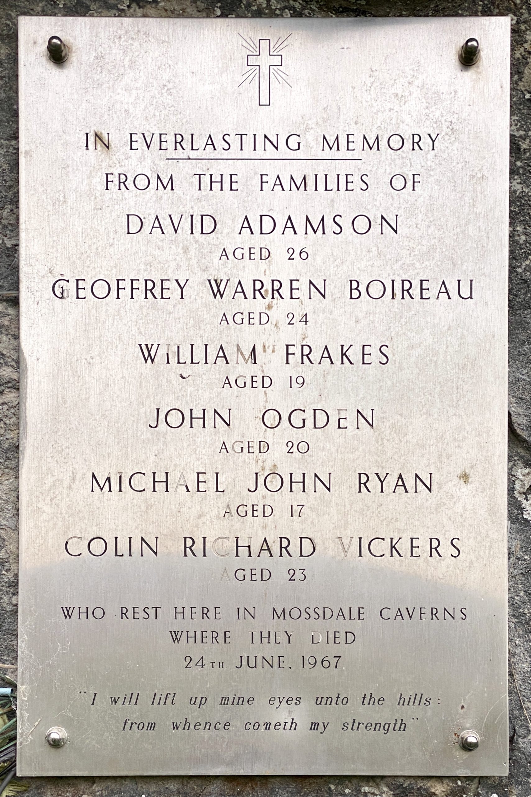
The 1967 Mossdale Caverns tragedy
The cave system is notorious amongst cavers in the United Kingdom for a tragedy that occurred on 24 June 1967. On that day, ten cavers entered the system. Three hours later, four members of the party decided not to continue and exited. One of these four returned to the entrance shortly afterwards, only to find it completely submerged due to recent rainfall having swollen Mossdale Beck. Realising immediately that the six cavers who remained inside the cave system were in danger, she ran 2½ miles across the moor to raise the alarm.
Cave rescue teams arrived at the scene, but the high water levels prevented access to the cave. The waters of Mossdale Beck had to be diverted away from the cave entrance by digging a trench. Even then the rescue operation could not be started because of the high water levels inside.
It was not until the following day that entry was possible. The cave rescue teams found the bodies of five of the cavers in the Far Marathon Crawls, and Bob Leakey led a search party to a location where he believed the sixth might have survived, but without success. The sixth body was located the following day. The bodies were left in situ. The coroner decided to seal the cave, and concrete was poured down the only safe entrance. This was later re-opened and in 1971, with the agreement of their families, the bodies were buried by their colleagues from the ULSA in “Mud Caverns”, a chamber at the far end of the system.
This is to date the most deadly incident in British caving. A memorial plaque is affixed to the cliff above the entrance.
Information from https://en.wikipedia.org/wiki/Mossdale_Caverns
Young cows blocking my path so I decide to ‘take the high road’.

Kendal Mint Co Energy Gel with Citrus and Mint Flavour
AD Kendal Mint Co energy gels deliver 27g of fast-absorbing carbohydrates plus electrolytes and B vitamins for improved performance. Vegan, gluten free, and Informed Sport certified, these caffeine-free gels are refreshing, easy to digest, and ideal for running, cycling, and endurance.
Beautiful limestone pavement at the bottom of Bycliffe Road where it meets the Dales Way.

The view across to the southern end of the Birks Fell ridge which divides Littondale and Wharfedale.


Thermos Stainless King Flask for Travel and Daily Adventures
AD The Thermos Stainless King 470ml flask keeps drinks hot for 18 hours or cold for 24. With durable stainless steel, vacuum insulation, a serving cup, and a leakproof design, it is perfect for commutes, journeys, and outdoor adventures.
Looking west across Wharfedale from Swineber Scar to Kilnsey Crag.

Highgate Leys Lane (Track) forming part of the Dales Way back to Kettlewell.

Thermos Stainless King Flask for Travel and Daily Adventures
AD The Thermos Stainless King 470ml flask keeps drinks hot for 18 hours or cold for 24. With durable stainless steel, vacuum insulation, a serving cup, and a leakproof design, it is perfect for commutes, journeys, and outdoor adventures.