ADVERTISEMENT
Fishing Villages, Ironstone History and Clifftops on the Runswick Bay Walk
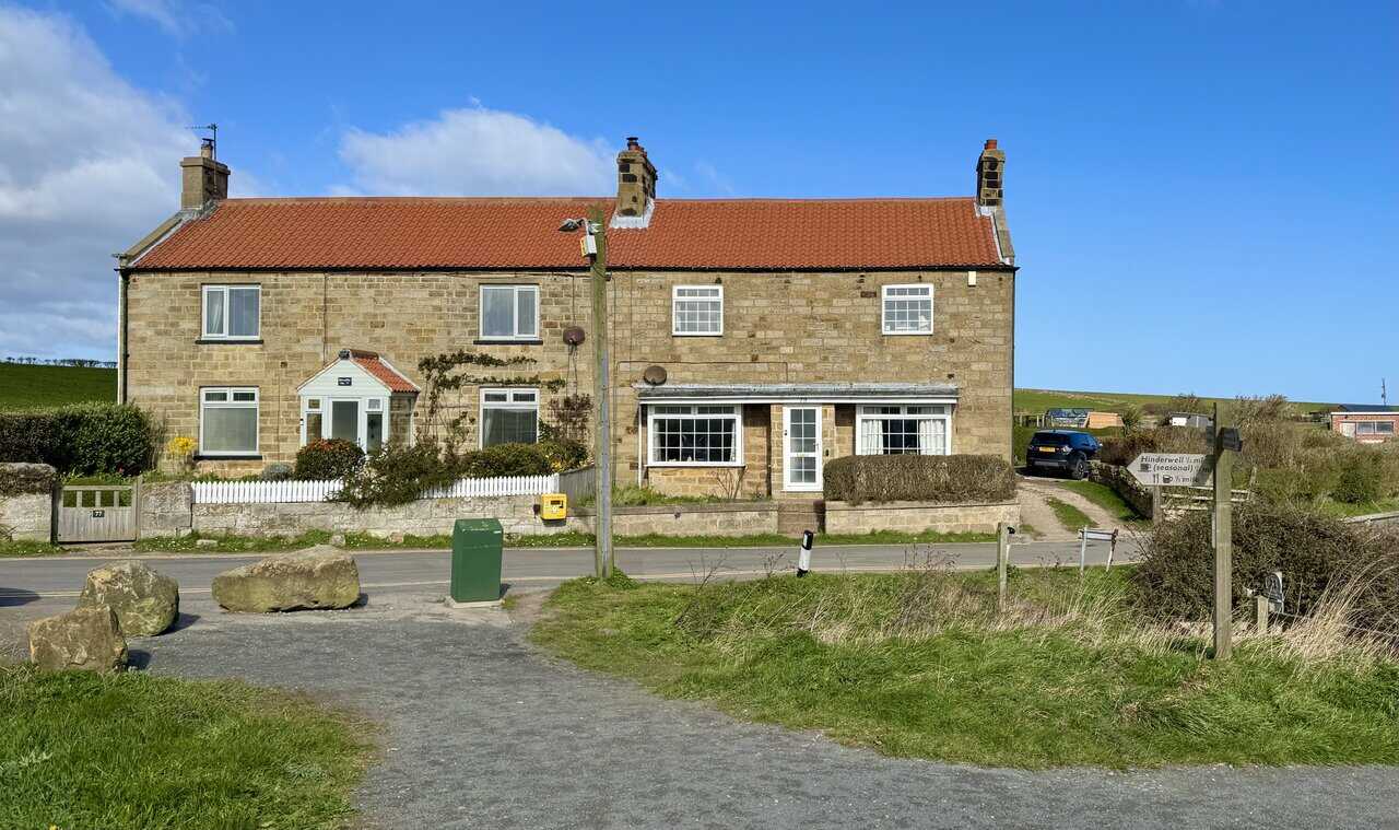
Start your Runswick Bay walk at Runswick Bank Top, where there are two large pay and display car parks on Bank Top Lane. From either car park, exit and turn left onto Bank Top Lane, then turn left again almost immediately and follow the downhill road signposted to Runswick Bay beach. Follow the steep road downhill towards the coast. About three quarters of the way down, just before you reach a car park on your right-hand side, you will see a tarmac lane on your left signposted as the Cleveland Way. Do not take it yet. Continue down to the beach first to explore the lower village.
At the bottom of the hill you will reach a mini roundabout. Straight ahead over the roundabout will take you down to the beach, where there is a cafe, shop and toilet facilities. Left at the roundabout will take you into the lower village of Runswick Bay to explore its cottages and maze of narrow streets and pathways. Both are well worth the time. When you are ready, walk back up the hill to the tarmac lane you passed earlier, signposted as the Cleveland Way, and follow it.
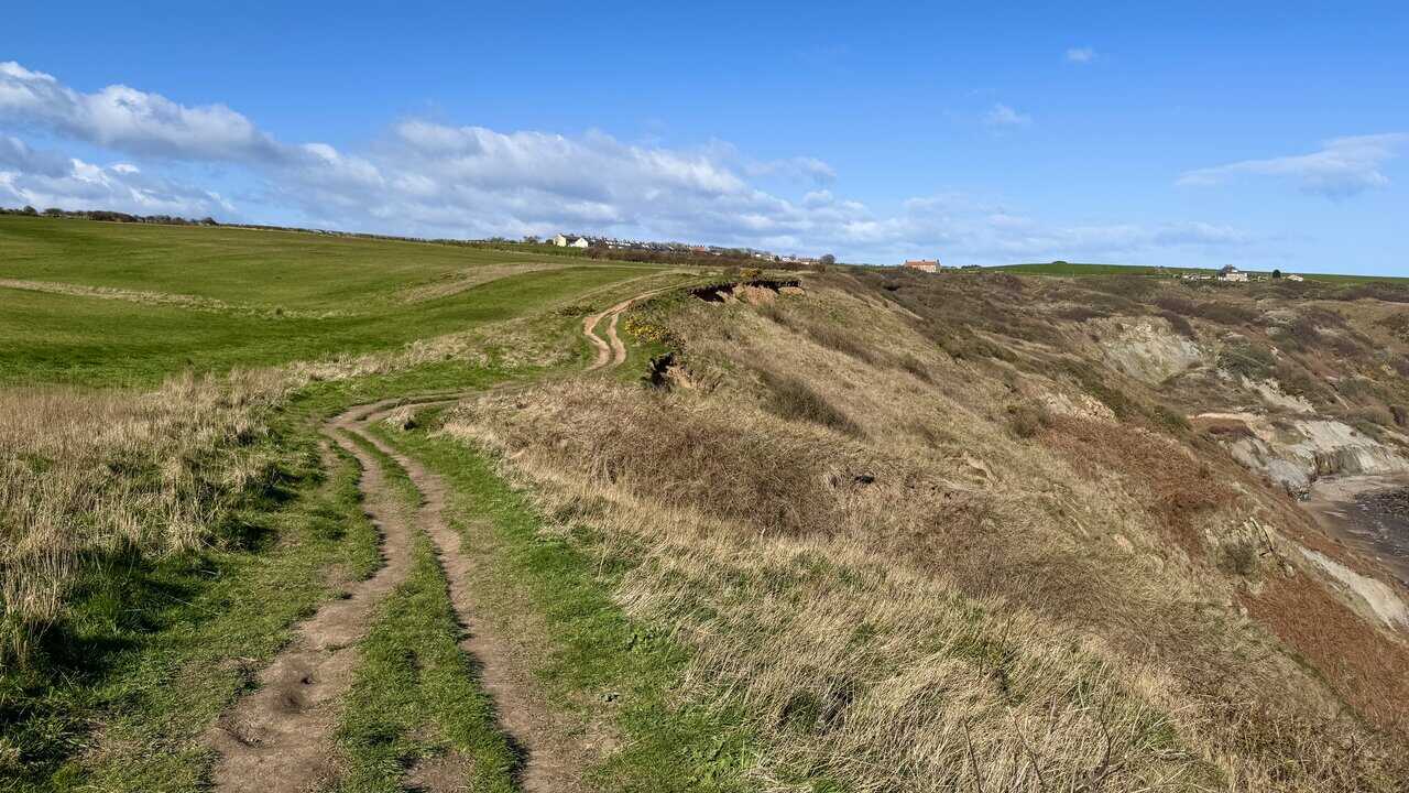
Keep straight ahead along this tarmac lane. It eventually becomes a footpath, still on the Cleveland Way. Follow the footpath as it winds its way up the hillside until you rejoin Bank Top Lane. Continue along Bank Top Lane until you reach a stone track on your right-hand side, immediately before a house called The Cow Shed (number 15). Follow the stone track, passing the Northern Powergrid brick building on your left. A little further along, take the grassy path on the right-hand side between the fence and the hedgerow. Follow this path to reach the clifftop and continue walking along the top of the cliff. After a third of a mile you will reach a junction with the Cleveland Way. Continue straight ahead.
Head north along the Cleveland Way above Lingrow Cliffs, following the clifftop coastal path. After a mile you will reach a junction where the path splits. The right-hand path drops down onto the cliffs, but instead take the left-hand path along the gravel track, staying on the Cleveland Way. You will reach the road at Port Mulgrave, where a signpost points left to Hinderwell. Ignore this and turn right, following the tarmac road signposted Cleveland Way to Staithes. This road is called Rosedale Lane.
ADVERTISEMENT
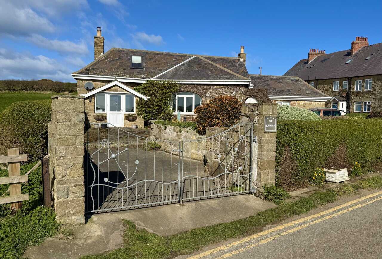
Continue past the bungalow called The Boat House, past the terraced stone cottages and past a second bungalow a short distance further on. Keep following the gravel path along the top of the cliffs, signposted Cleveland Way to Staithes. After half a mile the path splits again. Take the right-hand fork for the Cleveland Way public footpath along the edge of the cliff. You are now entering the National Trust area known as Old Nab.
After a further half a mile the Cleveland Way bends left and heads inland to reach a farm. In front of the farm, turn right and pass by the front of Barn Cottage. Head downhill towards Staithes. The stone path descends and joins a cobbled lane. Keep heading downhill until the lane brings you out onto the harbourfront. Turn left and follow the cobbled street past the Cod and Lobster pub, continuing between the houses, shops and cafes.
At the point where the cobbled street bears around to the left, do not follow it. Instead, continue straight ahead down a narrow flagged alleyway between the buildings. This leads to the footbridge over Staithes Beck. Cross the bridge and turn right to explore the harbour area. You can walk all the way along the breakwater to its far end if you wish.
When you are ready, retrace your steps back over the bridge and through the alleyway. Turn right and follow the road uphill for half a mile, all the way out of the village. When you reach the A174 main road, turn right in the direction of Loftus and Saltburn. A short distance further on, turn left onto Dalehouse Bank, signposted Dalehouse, Borrowby and Roxby, and head downhill.
ADVERTISEMENT
In Dalehouse, walk past the Fox and Hounds on your right. Just before the bridge over the small stream, take the public footpath on your left. This starts as a concrete driveway and soon becomes a wide gravel track following the route of a former railway tramway. When you reach a wooden footbridge over a stream near some caravans, cross the bridge and bear left, then immediately right to follow the track uphill. At the top, continue straight ahead, ignoring the left turn.
Follow the track through Oakrigg Wood Nature Reserve, passing wooden sculptures and carvings along the way. The track gradually narrows into a woodland path, but it remains well defined and easy to follow. When the path splits near the yellow Oakrigg Nature Reserve sign, take the left-hand fork onto the higher path. Continue along this narrow path with the valley down to your left. The path passes through an area of twisted, gnarly trees with ivy-clad branches forming a low canopy overhead.
At a junction, turn left and descend some wooden steps into the valley. Cross a wooden footbridge at the bottom and climb the steps on the other side to make your way back up out of the valley. At the top, follow the stone track straight ahead towards Hinderwell. The track narrows to a path past some farm buildings. Keep following it straight ahead, passing between some houses, until you reach the A174 main road in Hinderwell.
Cross the road and walk down Old High Street opposite, signed Port Mulgrave. A short way down on the left you will find St Hilda’s Church and, in the churchyard, St Hilda’s Holy Well. Both are worth visiting. After your visit, return to the A174 and turn left to walk through the village of Hinderwell.
Walk through the village until you reach the war memorial clock tower near the far end. Take the road on the left here, signposted Runswick Bay. Follow this road for one mile. There is a footpath beside the road all the way. The road brings you back to the car parks at Runswick Bank Top where you started, completing your Runswick Bay walk.
Runswick Bay Walk: Maps and Tools
Visit either the OS Maps website or the Outdooractive website to view this walking route in greater detail. Both platforms offer a range of features, including the ability to print the route, download it to your device, and export the route as a GPX file. You can also watch a 3D fly-over and share the route on social media. Additionally, this page includes a printable version of the walk in PDF format. Plus there is a supporting video, available for you to watch on YouTube.
Runswick Bay Walk: Distance, Duration, Statistics
Distance: 8¼ miles
Distance: 13 kilometres
Duration: 4 hours
Ascent: 1080 feet
Ascent: 329 metres
Type: Circular walk
ADVERTISEMENT
Recommended Ordnance Survey Map
The best map to use on this walk is the Ordnance Survey map of the North York Moors Eastern Area, reference OS Explorer OL27, scale 1:25,000. It clearly displays footpaths, rights of way, open access land and vegetation on the ground, making it ideal for walking, running and hiking. The map can be purchased from Amazon in either a standard, paper version or a weatherproof, laminated version, as shown below.
North York Moors Walking Guidebooks
North York Moors Pathfinder Walking Guide, by Brian Conduit and Dennis Kelsall, describes 28 circular walks of 3 to 11 miles from the coast at Whitby to the Cleveland Hills, graded by length and difficulty, with OS Explorer map extracts, GPS waypoints and parking information for every route.
100 Walks in Yorkshire: North York Moors and Wolds, by Gary Richardson, offers routes of up to 10 miles to suit all abilities, with easy-to-follow directions, Ordnance Survey route maps, and details of parking and places to eat and drink. Both books can be purchased from Amazon, as shown below.
North York Moors Pathfinder
About Runswick Bay
Runswick Bay is one of the most striking locations on the North Yorkshire coast, sitting roughly nine miles north-west of Whitby. This crescent-shaped bay lies within the North York Moors National Park and was named Beach of the Year by The Sunday Times in 2020. The village is divided into two distinct parts: the modern hamlet of Bank Top on the cliff edge and the historic lower village, where red-roofed cottages huddle together against the steep shale cliffs. Visitors find the descent into the bay provides a stunning view of white sands and narrow paths that seem to belong to a different era.
A Village Rebuilt from History
The structure of the modern village is a direct result of the Great Landslide of 1682. This catastrophic event saw the original settlement, which was located slightly further to the north, almost entirely destroyed as the cliff face failed. In one of the most remarkable episodes of coastal history, a wake was being held in a house on the night of the disaster. Two mourners noticed the initial tremors and subsidence, allowing them to alert the rest of the community. Every inhabitant managed to escape to higher ground before their homes were swallowed by the sea, and no lives were lost. The villagers subsequently relocated to the more sheltered southern part of the bay, creating the narrow alleys and steep steps that define the lower village today.
Coastal Paths and Natural Beauty
For those who love to explore on foot, the village is a key milestone along the Cleveland Way National Trail. A Runswick Bay walk gives you the chance to see the rugged beauty of the North Yorkshire Heritage Coast first-hand. The path winds along dramatic clifftops before descending to the very edge of the sand. The beach is framed by low, wooded valleys that provide a soft contrast to the grey cliffs, and the area is valued for its sense of quiet and seclusion, offering walkers clear views across the North Sea.
Related Walk: Similar to the Runswick Bay Walk
Alum Works and Boggle Hole on the Ravenscar walk to Robin Hood’s Bay
A Jurassic Treasure Trove
The bay holds international importance for its geology, as the cliffs reveal rocks from the Early Jurassic period, dating back nearly 200 million years. Regular erosion of the soft shales continually exposes new material, making it one of the premier spots in the country for beachcombing and fossil hunting. While you are enjoying a Runswick Bay walk, it is common to find ammonites or belemnites among the loose pebbles on the shore. The area is also known for a rare Middle Jurassic flora, including the seed cones of the extinct plant Williamsonia gigas, which are preserved here in remarkable detail. Because the cliffs are a Site of Special Scientific Interest, visitors are asked to search for fossils in loose beach material rather than hammering the bedrock.
Legends of the Shoreline
The cultural identity of the area is closely tied to maritime folklore, particularly the stories of the “Hob” said to live in the caves at the edge of the shore. These caves, known as Hob Holes, were formed by wave action and expanded by 19th-century jet miners. In local tradition, the Runswick Hob was a benevolent spirit and a healer. Up until the late 1800s, mothers would carry children suffering from “kink-cough” or whooping cough to the cave at low tide, calling out to the Hob for a cure. While seen as a healer, some maritime tales also spoke of a mischievous side, suggesting the Hob might use a lantern on stormy nights to decoy unwary travellers into rocky pools.
The Character of the Village
The lower village is known for its distinctive appearance, with sandstone cottages topped by red pantiles. These clay tiles are said to have been originally brought over as ship ballast from the Low Countries. One of the most recognisable landmarks is the white-painted Thatched Cottage, the only remaining thatched house on this part of the coast, which once served as a home for the local Coastguards. After a day of exploring the beach or walking the clifftops, the village offers good places to stop and refuel. The Royal Hotel is a family-owned pub in the lower village with views across the bay, while the Runswick Bay Hotel at the top of the hill is well regarded for its welcoming atmosphere. The community remains close-knit and continues to support an independent volunteer rescue boat service, carrying on a long tradition of life-saving along this stretch of coast.
Runswick Bay Walk: My Photos
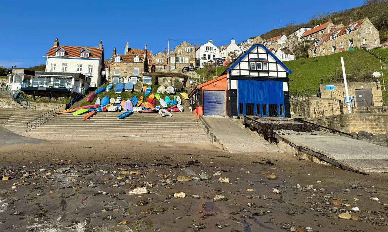
I leave the car park at Runswick Bay and make my way down the steep, one-in-four road into the lower village. This is the heart of the settlement, a place best understood as a village of paths, steps and narrow links rather than one planned around roads. An earlier village once stood a little further north, but in the 1680s, after a catastrophic landslip, the entire settlement fell into the sea and was rebuilt on this slightly more southerly site. The steeply raked cottages now look out over one of the finest sandy bays in northern England, a charming place of tightly packed houses, pocket-sized gardens and surprise views. Many of the red-roofed houses have been much altered over the years, but were once home to herring fishermen and their families.
ADVERTISEMENT
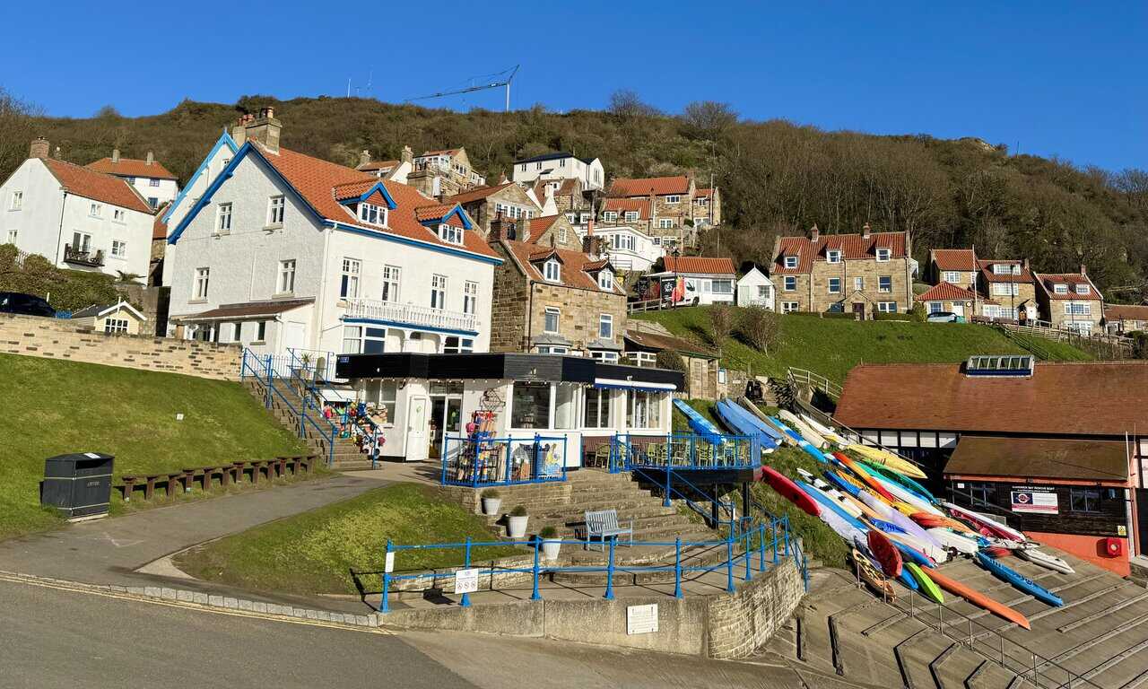
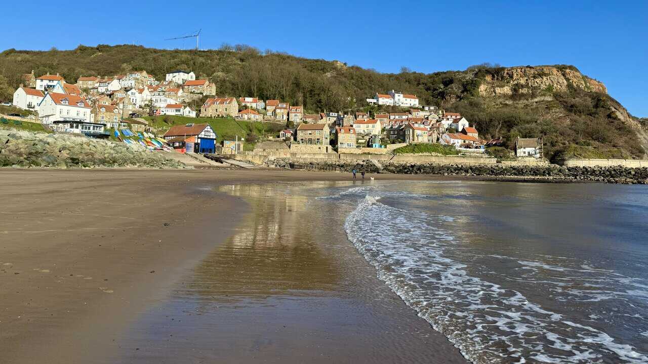
From the beach I look up to the village, where stone and rendered cottages climb the hillside in tight, overlapping rows. Red clay pantile roofs, chimneys and dormers give the roofscape a layered, almost vertical quality, and what makes the scene memorable is the contrast between the open sweep of the beach and the densely packed settlement above. The half-timbered lifeboat station with its bright blue doors stands at the foot of the slope. Twenty boats or more worked out of Runswick Bay in the 1840s, but a century later the industry was gone.
I wander onto the beach, where the wet sand mirrors the village above. The bay is broad, curved and sheltered, framed by headlands on either side that give it a calm, enclosed feel quite different from more exposed parts of the coast. At low tide, wide stretches of sand open up, making it a popular spot for families, dog walkers and beachcombers. This stretch of coast is noted for its Jurassic geology, and the bay is well known for fossil hunting and rock pooling, with ammonites and other ancient material found along the shoreline. Sturdy sea walls and defensive boulder piles have been added in modern times to protect the village from the sea.
ADVERTISEMENT
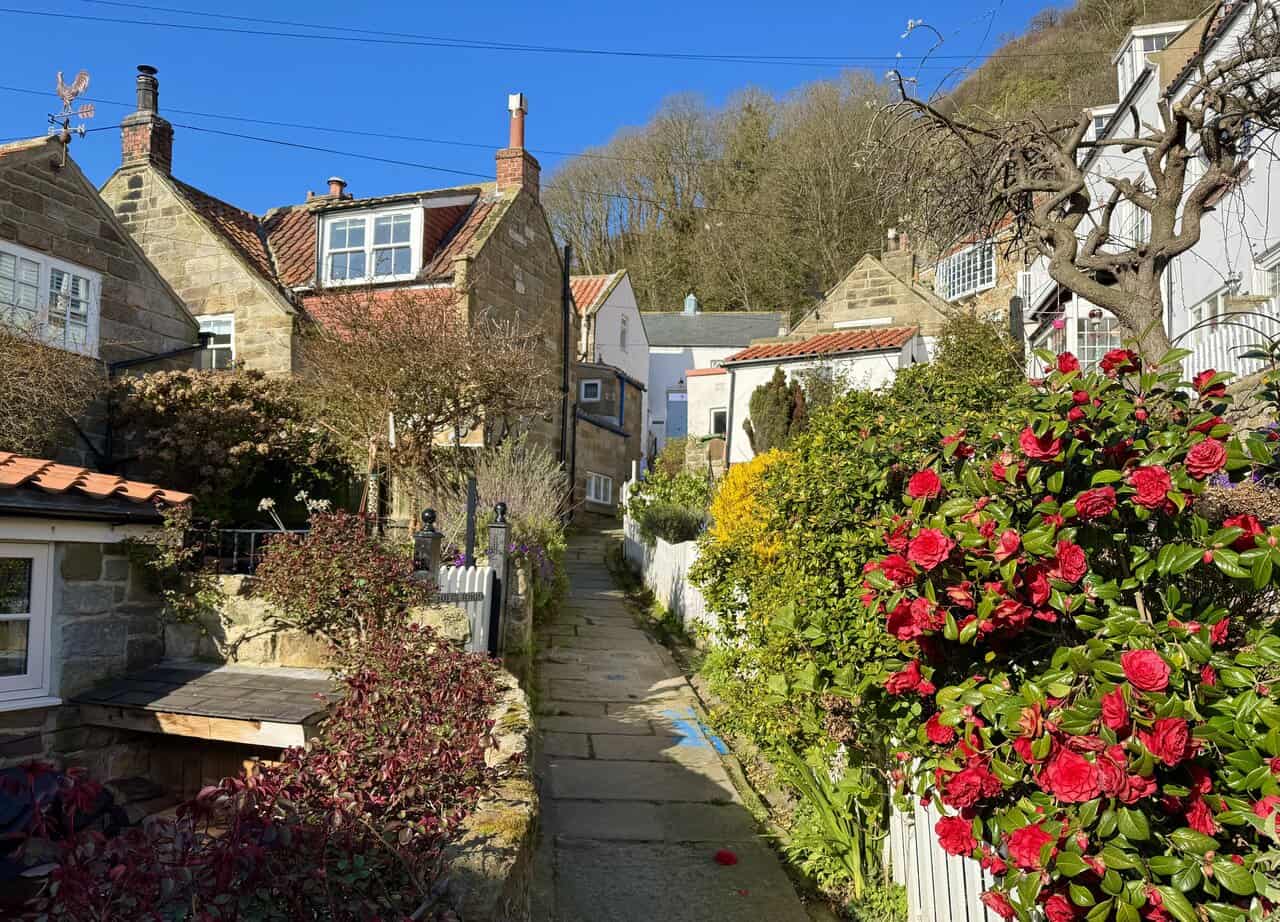
I spend some time exploring the lower village, wandering through its narrow passages and ginnels. Sandstone cottages and white-rendered walls press close on either side, with front gardens spilling over with colour. An old iron lamp stands among camellias and aubretia, while iron balconies, white picket fences and pantile roofs layer up the slope towards the exposed rock of the cliff above. Many of the cottages front directly onto these paths, with little or no front garden, so the detail is seen at close quarters. The fishermen who once lived here grew vegetables in the tiny gardens and stored their catch in the herring houses.
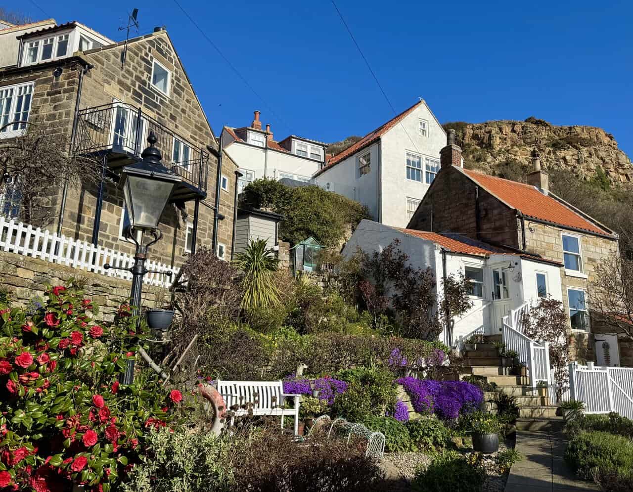
Flagstone paths climb between the cottages, twisting and rising with the terrain. The village is experienced in fragments rather than along any clear main street, each turn revealing another tight corner, another flight of steps, another sudden view through the rooftops. It gives the place a layered, almost maze-like quality that rewards a slow wander.
ADVERTISEMENT
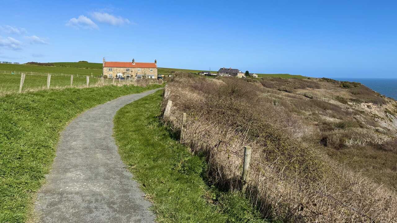
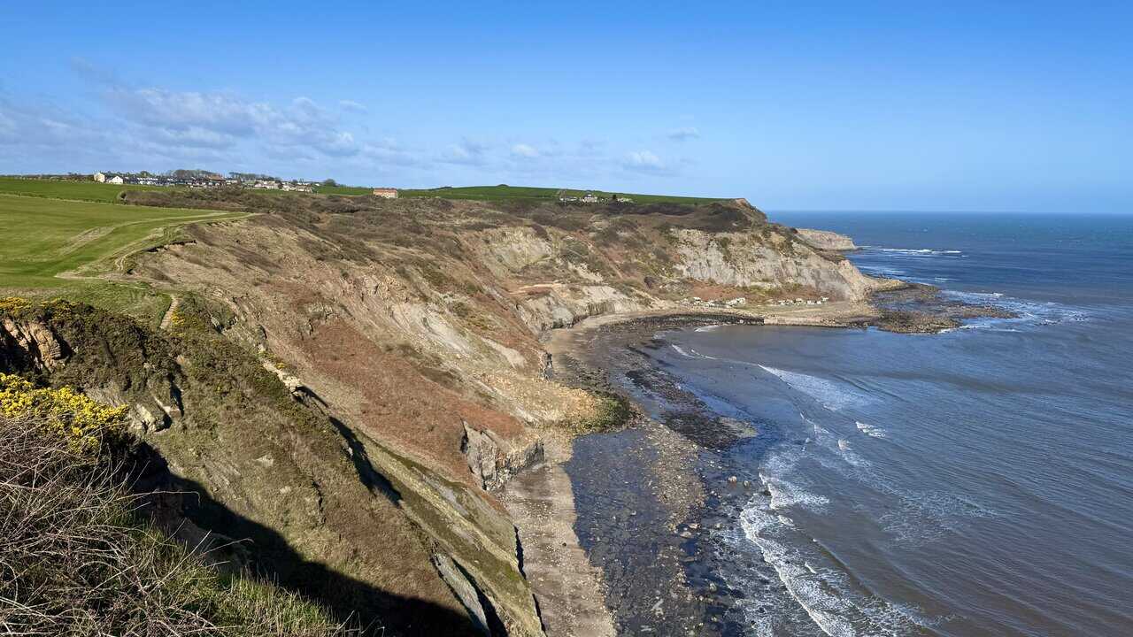
From the village I make my way up onto the coastal path and join the Cleveland Way, where the first clifftop views of this Runswick Bay walk open up ahead. Above Wrack Hills, the grassy cliff slopes fall steeply to a dark, rocky shoreline below, with waves breaking gently against the scattered boulders. The character of the coast changes quickly here, from the sheltered bay behind to something altogether more rugged and exposed.
Walking along Lingrow Cliffs, the scale of the coastline really opens up. The cliff faces are layered and banded with exposed Jurassic rock, including the Staithes Sandstone, Cleveland Ironstone and Whitby Mudstone, which gives them a structured, striated appearance in tones of ochre, grey and rust. These cliffs also preserve traces of the area’s industrial past, including ironstone mining, alum workings and old harbour remains.
ADVERTISEMENT
The Cleveland Way follows the cliff edge north towards Port Mulgrave, with green farmland on one side and the open sea on the other. A set of steps leads down into a small valley and then back up the other side, one of many short, sharp descents and climbs along this stretch. The Cleveland Way is one of England’s original National Trails, opened in 1969 and running for around 109 miles from Helmsley to Filey. It is really two walks joined together: an inland moorland and escarpment route, and a coastal clifftop route.
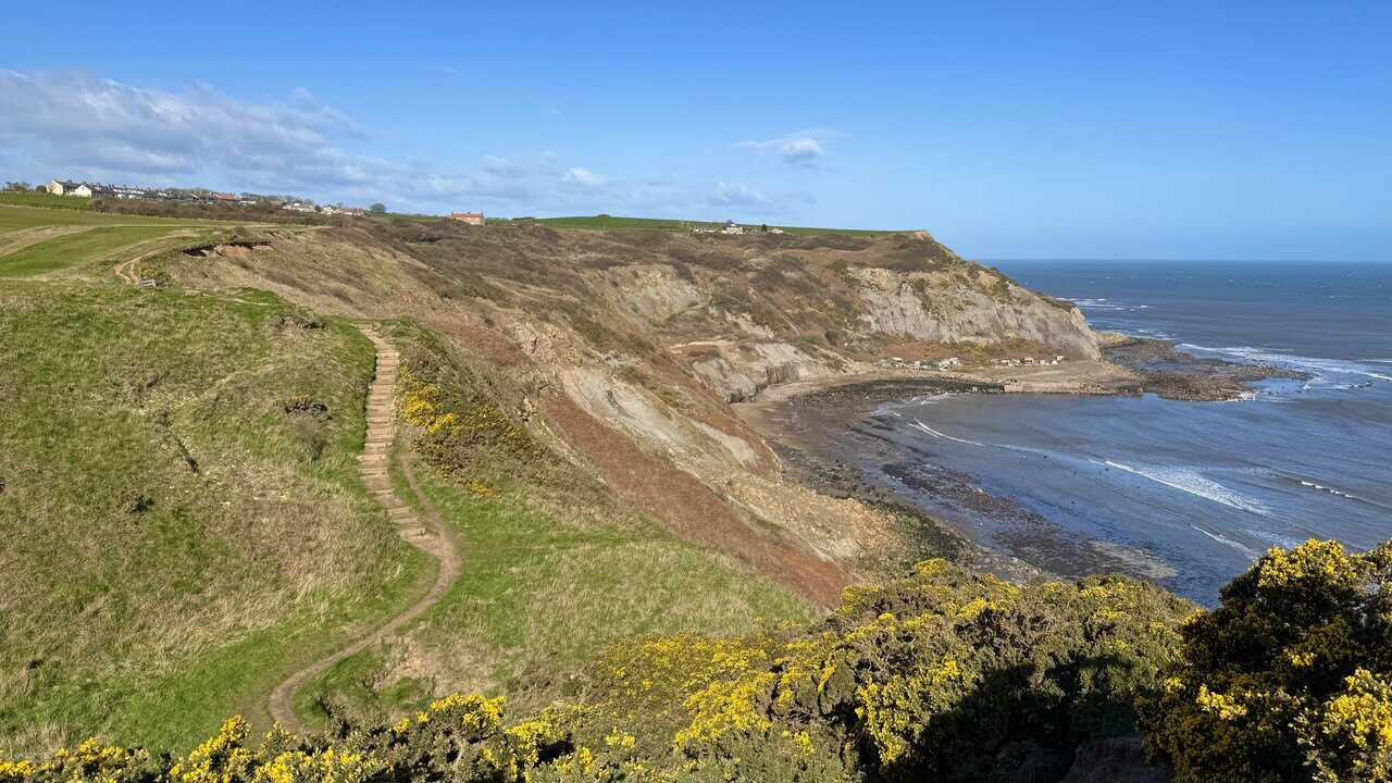
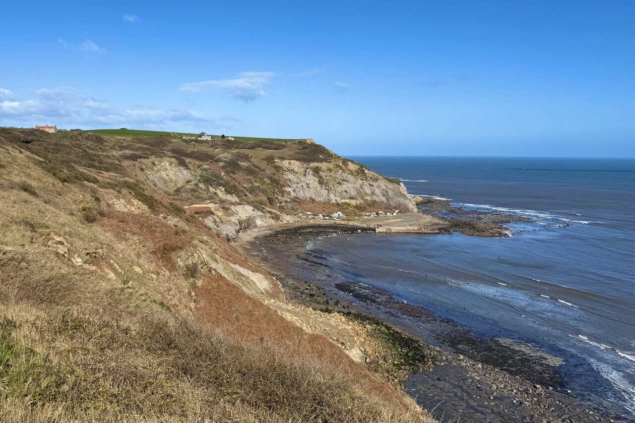
I continue along the cliffs and the small bay at Port Mulgrave comes clearly into view below. This peaceful spot would once have looked very different. The growth of the railways and shipbuilding during the nineteenth century led to an enormous surge in the demand for iron, and ironstone mining began here in 1855. The cliffs would once have been ringing with the sound of machinery and miners going about their work, but today only a section of pier, the breakwater and the mine entrance remain of the industry that thrived here.
ADVERTISEMENT
The Cleveland Way continues along the clifftop, doubling here as the King Charles III England Coast Path, and the houses of Port Mulgrave come into view ahead. Local people worked in the mines, but labourers were also recruited from as far away as Norfolk, and cottages were built for them that were luxurious by the standards of the day, even offering their own pigsty. The labourers’ cottages were built at Far Rosedale, with those for the mine officials and mine manager located at the top of the cliff.
The path curves towards Port Mulgrave, running between green farmland and the cliff edge. Down below in the bay to my right, the pier has long since vanished, but it would once have featured an impressive wooden gantry with storage bunkers. Railway trucks were driven out of the mine and the ironstone was tipped into the bunkers before being loaded onto ships waiting below.
I reach the road through Port Mulgrave and pass the solid, red-pantiled sandstone houses that once served the mining community. When the ironstone here was exhausted, Grinkle Park Mine was opened three miles away, but the harbour at Port Mulgrave was still used to ship the stone, brought here by a specially constructed railway line until 1917. An accidental fire eventually destroyed the gantry, and the northern harbour breakwater was blown up by Royal Engineers during the Second World War to prevent German forces using the harbour as a landing point.
ADVERTISEMENT
I walk past The Boat House, a stone-built bungalow with iron gates set between sturdy sandstone pillars. The last remnants of the old machinery at Port Mulgrave survived until they were removed in 1934, and since then the site has gradually given way to the effects of time and the sea. It is a quiet, unassuming spot now, with little to suggest the scale of industry that once shaped this stretch of coast. I’m about one quarter of the way round my this Runswick Bay walk.
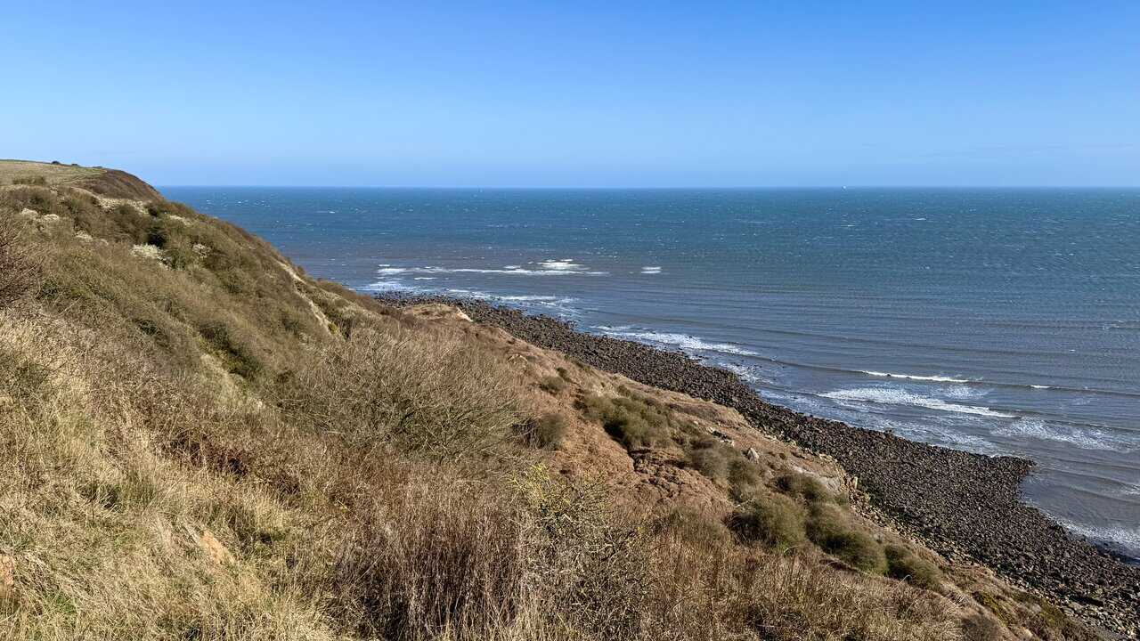
Continuing along the clifftop from Port Mulgrave, it is not long before I reach Old Nab, a bold headland of layered rock jutting out into the sea. The cliff face drops away sharply, its banded layers of sandstone and mudstone exposed and raw where the land has fallen away. Waves break against the dark rock platform below, and the scale of the coastline from up here on this Runswick Bay walk is striking.
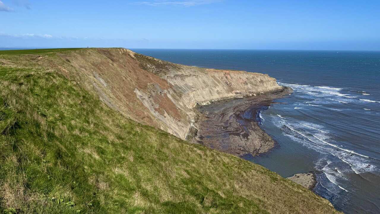
From Old Nab I look west along the coast, where the cliffs drop sharply to the rocky shore at Jet Wyke. Waves roll in across a broad rock platform, breaking in long, curving lines of white against the dark stone. It is a wild and open stretch of coastline, with no path down and no easy access from above.
ADVERTISEMENT
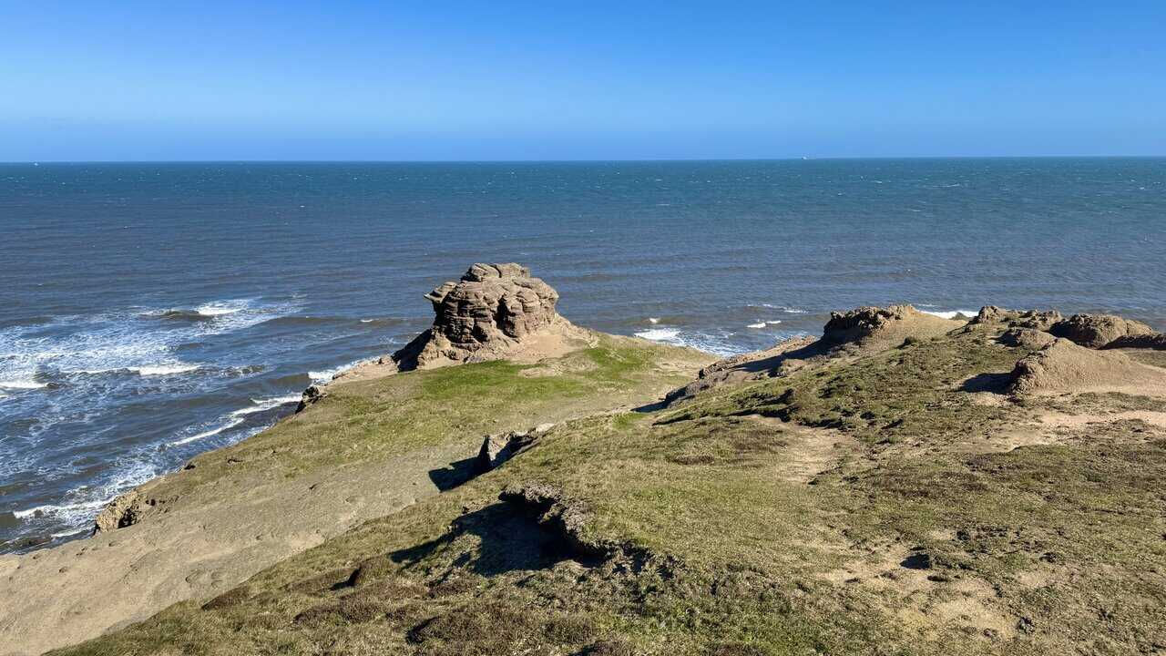
I reach the tip of Old Nab and pause to take in the view. Out on the headland, a strange, weathered stack of layered rock stands alone, sculpted by wind and rain into a rough, tiered shape. The ground around it is eroded and uneven, a reminder of how quickly this coastline is being reshaped by the elements.
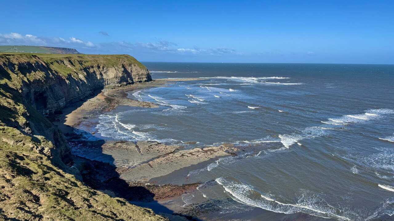
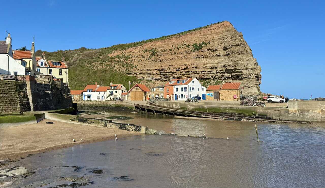
From Old Nab I continue along the Cleveland Way and suddenly Staithes comes into view, the village tucked into its narrow valley below with red pantile roofs packed tightly above the harbour. The breakwaters curve out into the sea, sheltering a handful of boats on the calmer water within, while beyond them the bold, rust-coloured cliff of Cowbar Nab rises sharply against the sky. Further inland, set back from the coast on the high ground above, the buildings of Boulby Mine stand out against the green farmland.
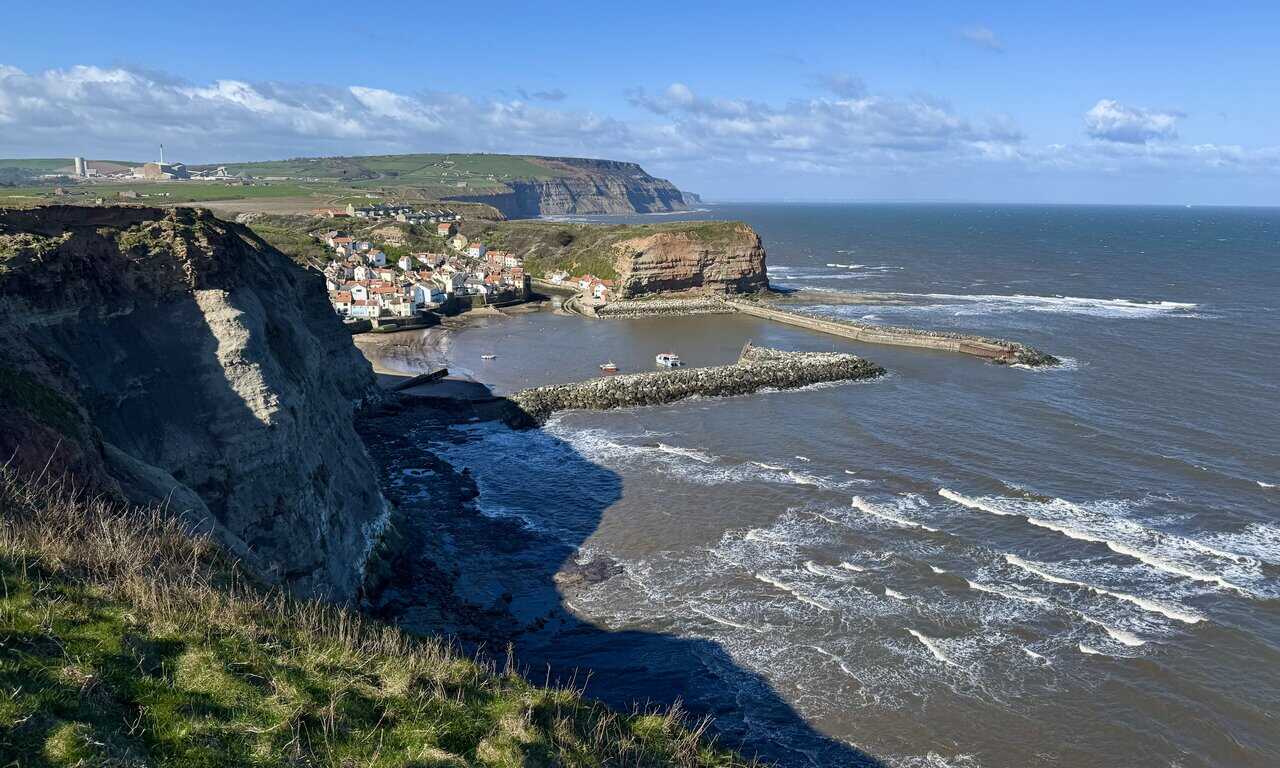
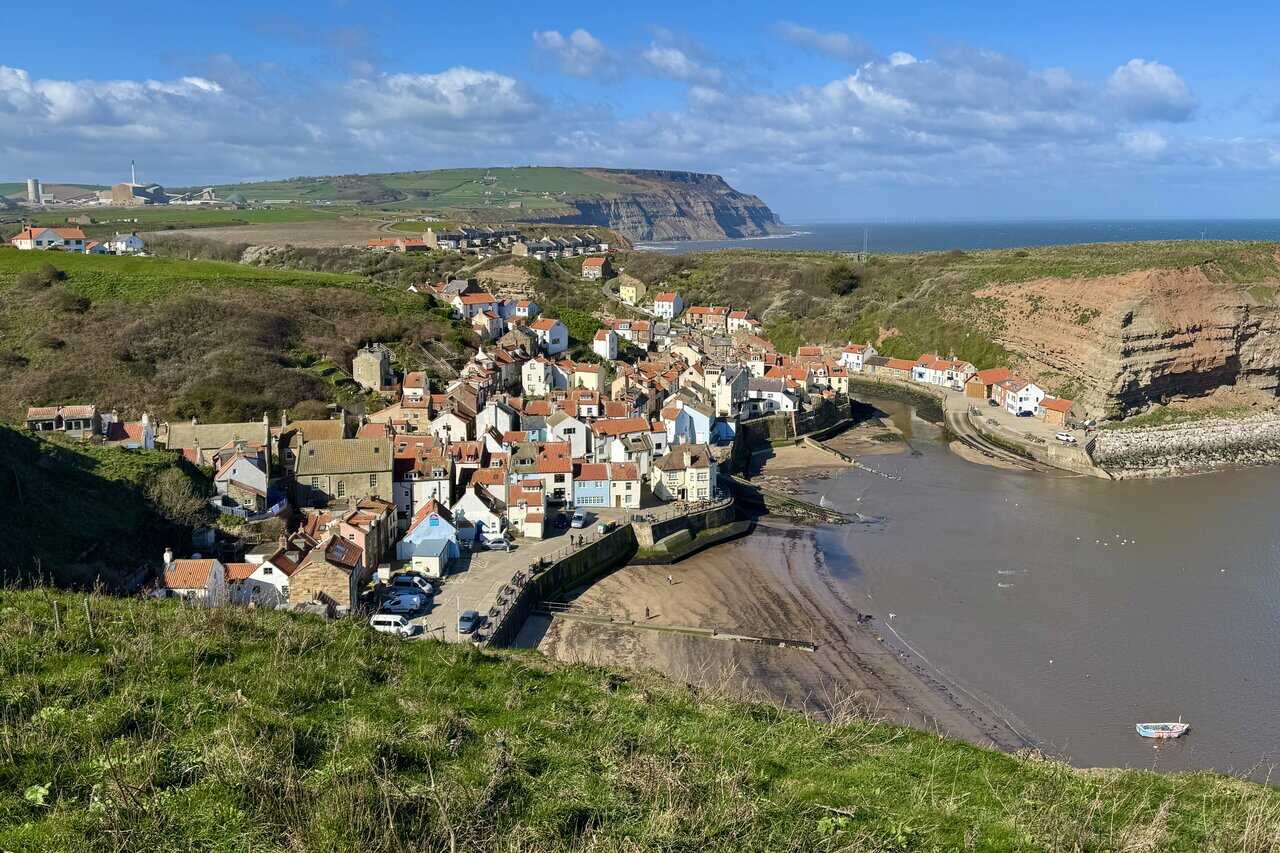
A little further along the path and I am looking straight down into Staithes, the full shape of the village now clear below. Houses in stone, cream render and pale blue crowd together on the eastern side of the Staithes Beck valley, overlooking the harbour where the tide has drawn back to reveal wet sand. Beyond the harbour, the red-faced cliff of Cowbar Nab guards the far side of the inlet, with Cowbar sitting on the hilltop on the western side of Staithes Beck. In the distance, the sheer face of Boulby Cliffs stretches along the coast, the highest cliffs on England’s east coast.
ADVERTISEMENT
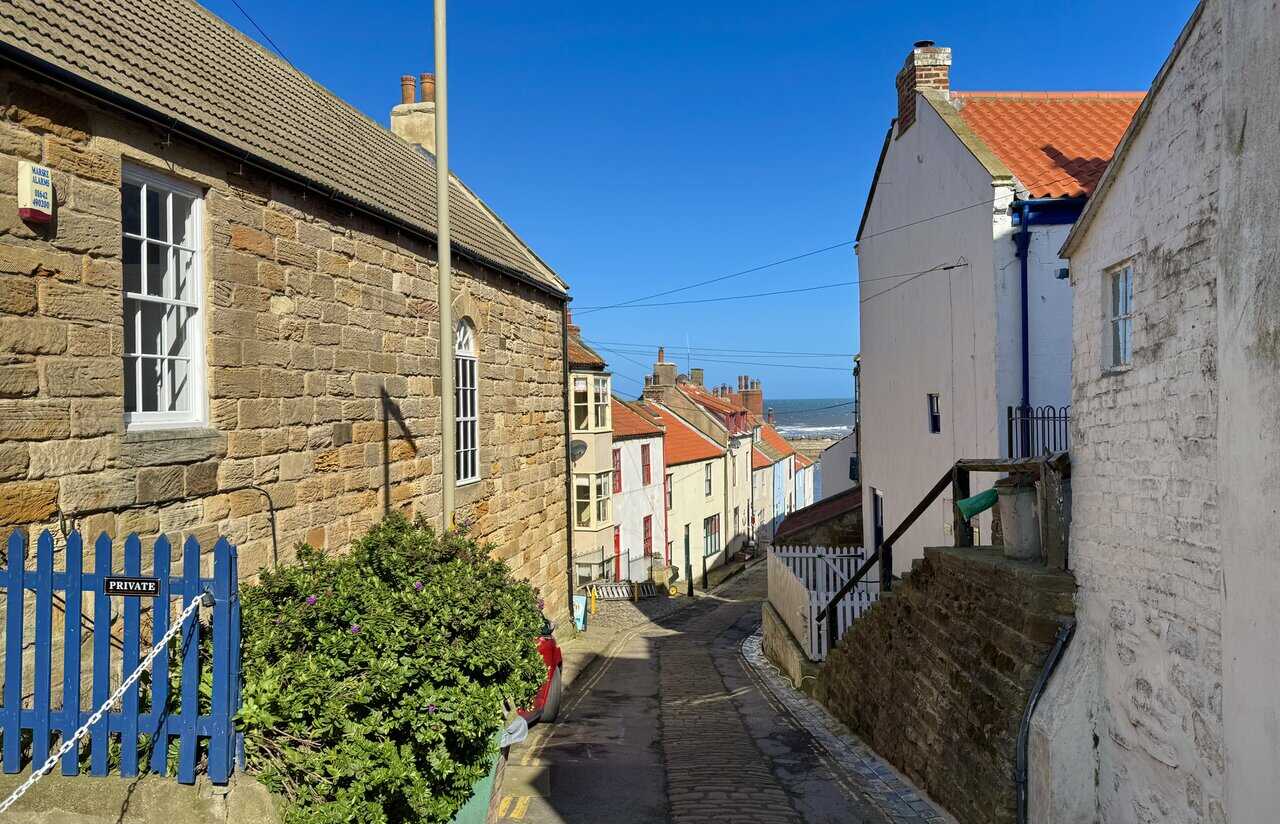
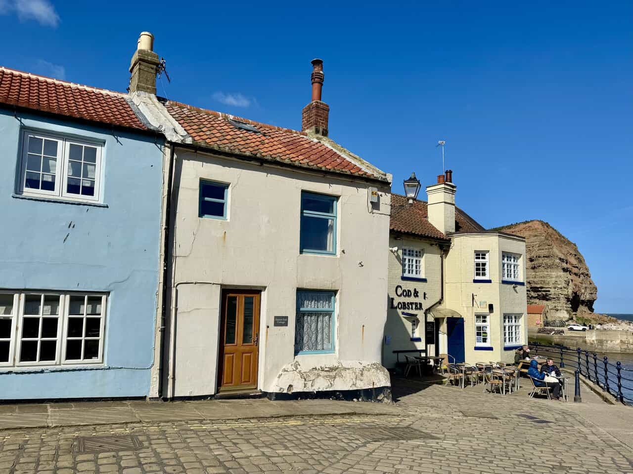
I follow the Cleveland Way down into Staithes along a narrow, cobbled lane that drops steeply between sandstone and white-rendered cottages. The sea appears in glimpses between the rooftops ahead, drawing me on. Staithes has a long history as a fishing port, and the young James Cook worked here as an apprentice to William Sanderson, a local grocer and draper, in 1744. He was just sixteen years old, but by 1746 he had left for Whitby and a life at sea.
The lane brings me out at the harbour front, where the Cod and Lobster pub sits in its prominent position at the water’s edge. Pale blue and cream-painted cottages press close on its left side, their pantile roofs and slightly cracked render giving them a well-weathered look. The pub has been rebuilt more than once after storm damage, but it remains one of the focal points of the village, with Cowbar Nab rising dramatically behind.
From the Cod and Lobster I look across the harbour towards Cowbar. The tide is low and Staithes Beck flows out past the harbour walls towards the open sea. A row of colourful cottages and other buildings lines the far bank beneath the towering red and brown cliff face of Cowbar Nab, and lobster pots are stacked along the quayside. In the nineteenth century, more than 300 men worked from this harbour, hauling in catches on traditional wooden cobles, flat-bottomed boats with a high bow designed for launching from shallow, sandy beaches.
ADVERTISEMENT
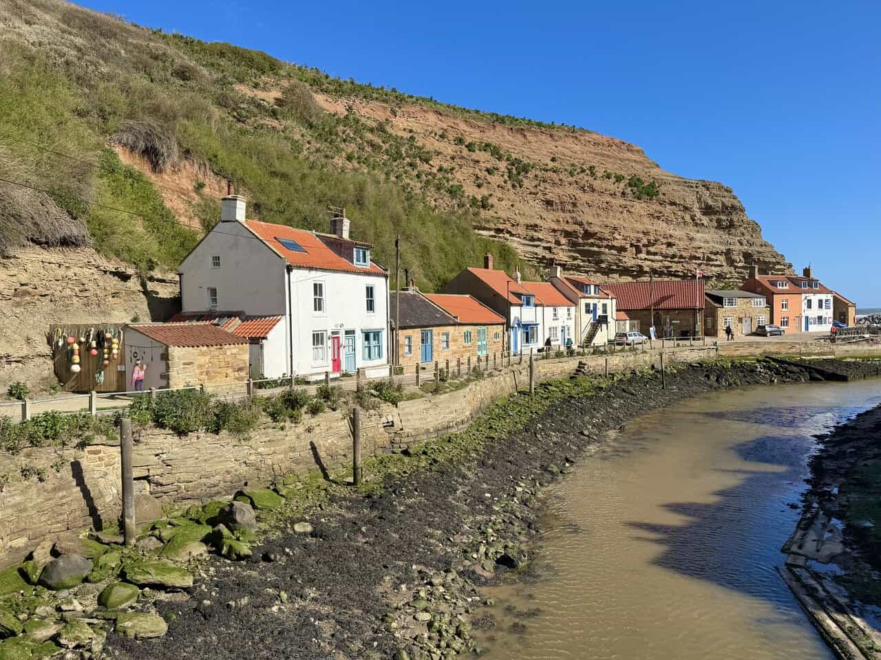
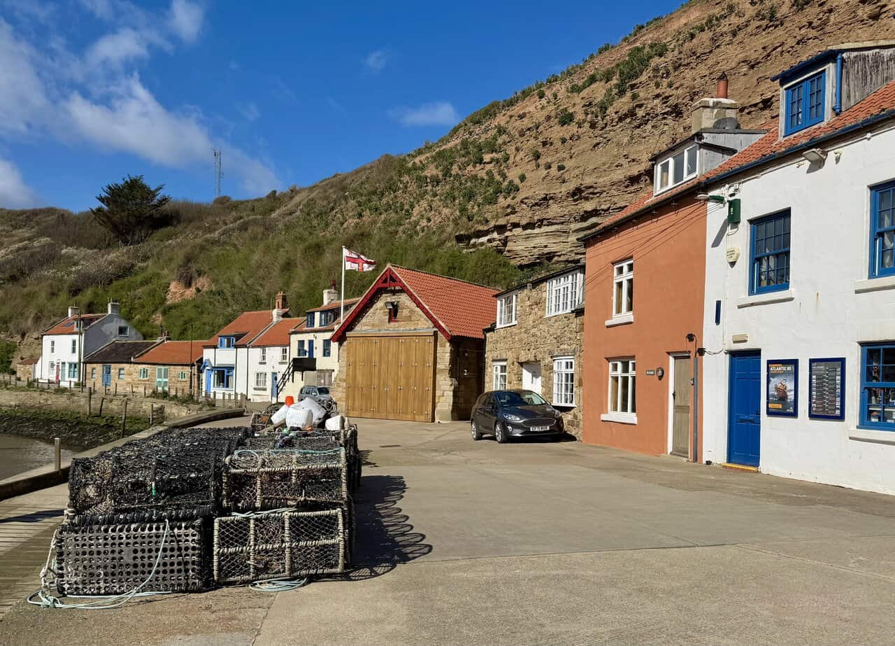
I cross the footbridge over Staithes Beck and walk along the Cowbar side, passing a row of brightly painted cottages with red, turquoise and pastel-coloured doors. Fishing buoys hang from the side of a small shed, and the exposed beck bed lies below. Staithes is still a working harbour, with a small fleet of cobles fishing for mackerel, lobster and crab, and the feel of the place is shaped as much by the sea as it ever was.
I make my way out towards the breakwater, on a concrete path between the heavy boulders piled along the harbour edge. These sturdy sea defences protect the village from the worst of the North Sea, with the concrete breakwaters extending out into the water beyond. The headlands of Cowbar Nab and Penny Steel provide natural shelter on either side, but the engineered defences are vital in keeping the harbour and the village safe.
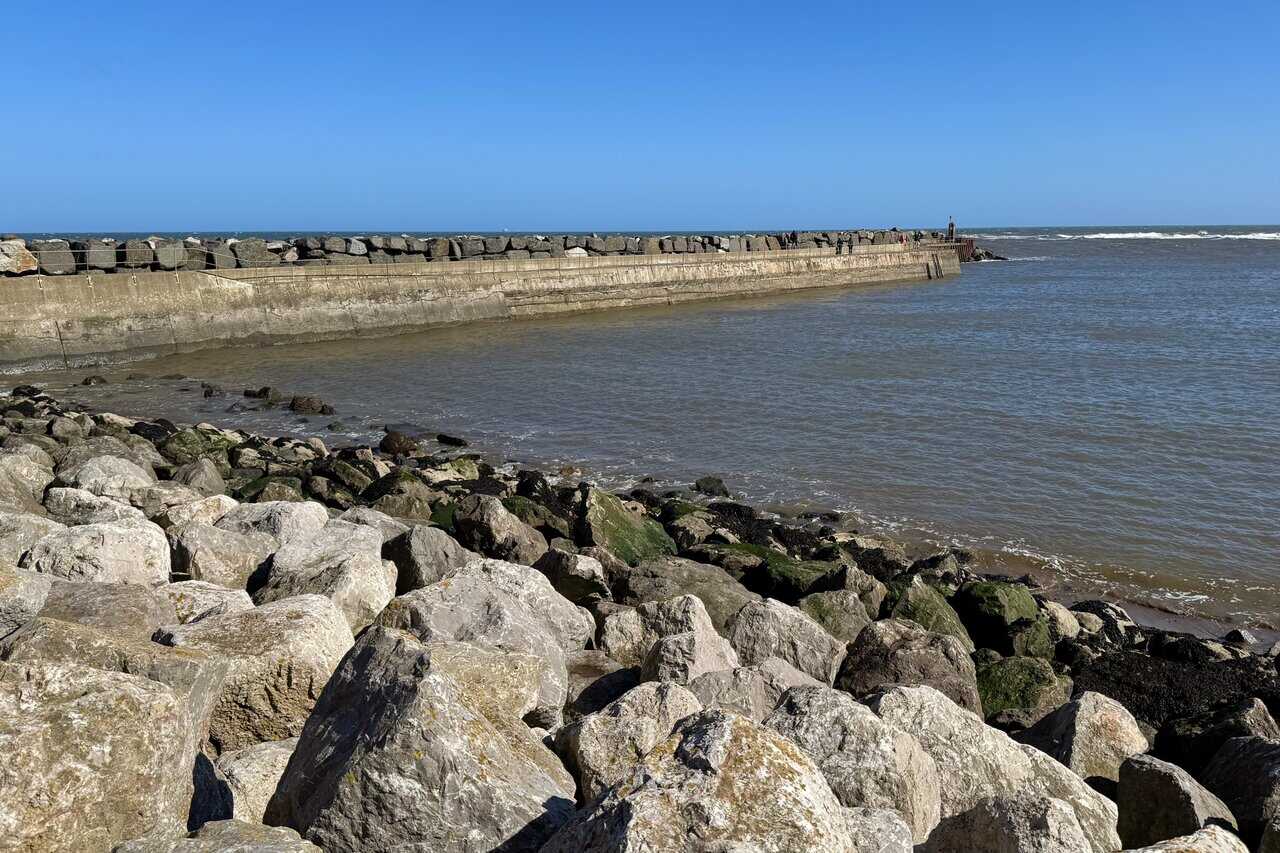
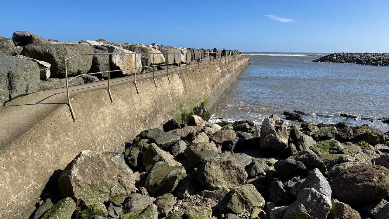
I walk out along the breakwater itself, its concrete surface worn smooth by the sea. Metal handrails line one side, and ahead of me a few walkers have made it to the far end where the structure meets the open water. It is a good place to appreciate the exposed position of Staithes and to understand why so much effort has gone into defending it from the sea. Staithes is roughly the halfway point of this Runswick Bay walk.
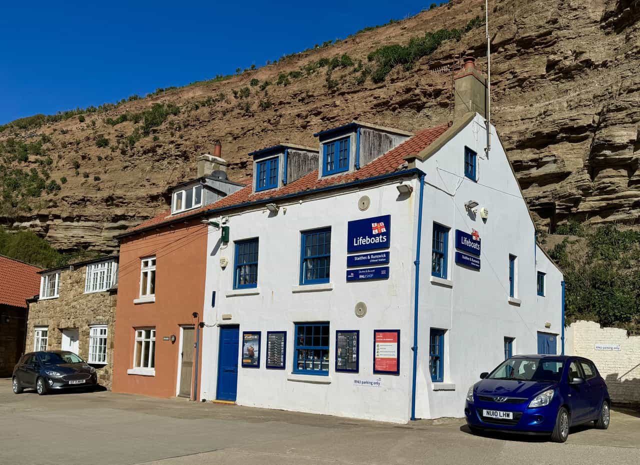
Returning from the breakwater, I pass the RNLI lifeboat house on the Cowbar side of the harbour. Lobster pots are stacked on the quayside and the lifeboat house doors are closed, its red-painted gable and flag marking it out among the stone and rendered cottages. The station was first established in 1875, when the lifeboat Hannah Somerset was inaugurated before a large crowd, and lifeboats have been stationed at Staithes and Runswick for more than 150 years, a connection to the sea that runs deep in both communities.
ADVERTISEMENT
The Staithes and Runswick Lifeboat Station stands prominently on the harbourside, its white-painted walls and blue trim unmistakable. The station currently operates an Atlantic 85 inshore lifeboat, Sheila and Dennis Tongue III, which has been on station since 2016, and its volunteer crews have earned nine awards for gallantry over the years. It is a fitting place to pause on this Runswick Bay walk and reflect on the long tradition of courage and service that links these two villages along the coast.
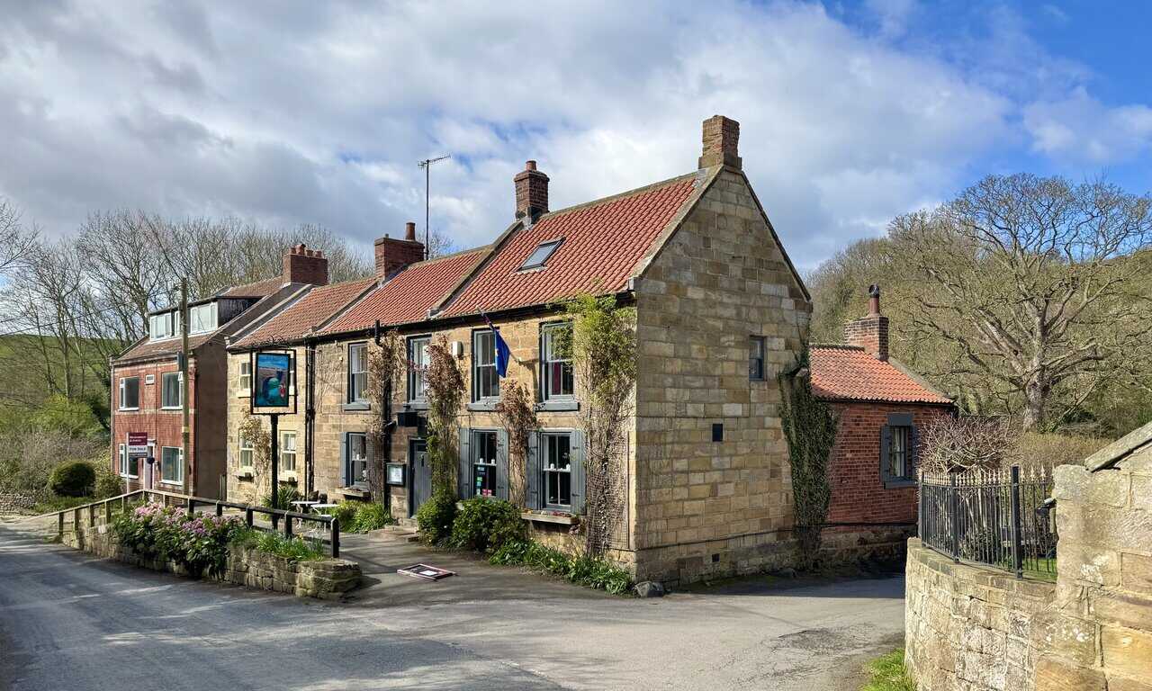
Climbing out of Staithes, I briefly join the main road before following a minor road down into the hamlet of Dalehouse. The Fox and Hounds sits at the roadside, a solid sandstone pub with red pantile roofs and climbing plants on its walls. It would be a welcome stop, but I am pressed for time and keep going.
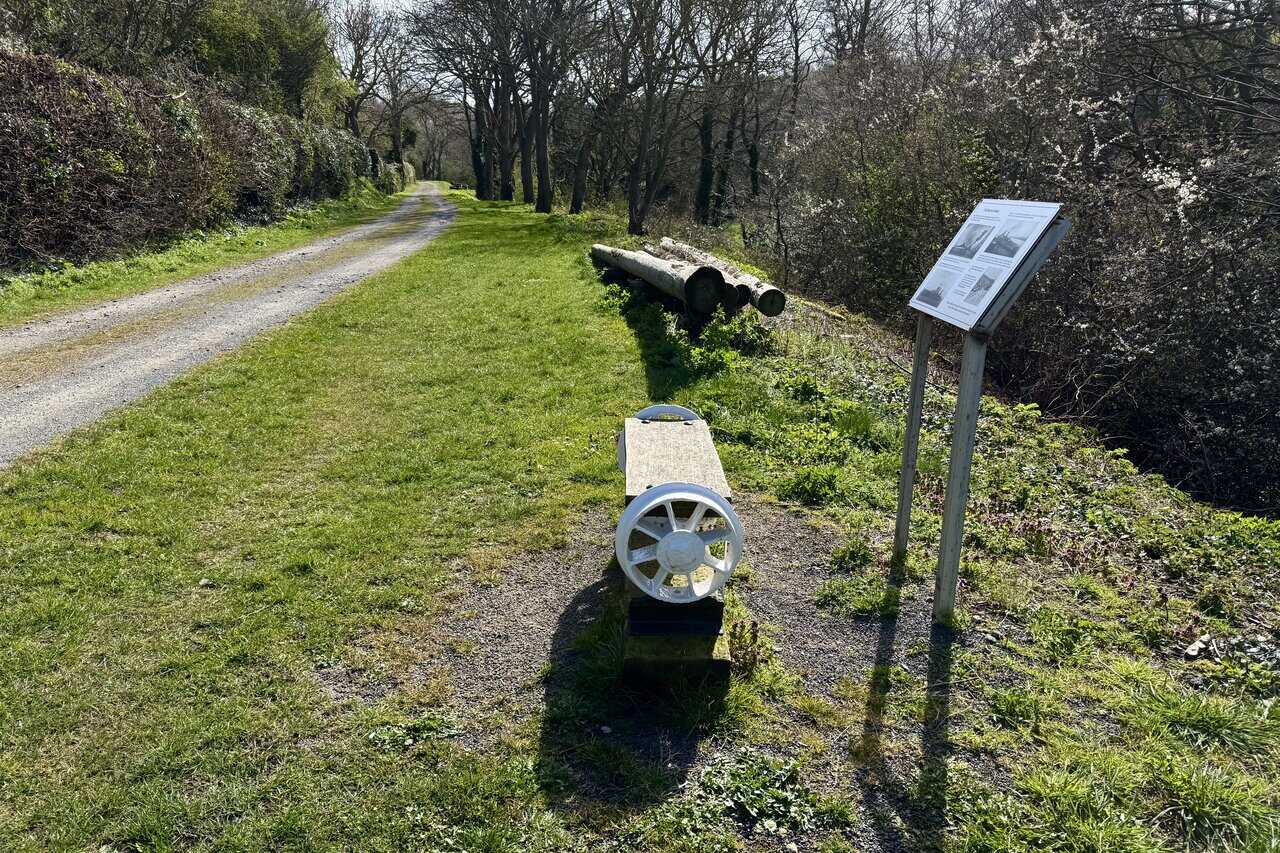
From Dalehouse I join a quiet, tree-lined path that follows the route of a former tramway. A bench made from old railway axles and sleepers sits beside an information board, and I stop to read it. The board tells the story of the Grinkle Ironstone Mine, from where a narrow three-foot tramline carried ironstone along this valley, through Dalehouse and through a tunnel to Port Mulgrave, where it was loaded onto ships and sent by sea to Jarrow on the River Tyne. In the early 1900s, three million tons of ironstone passed over these very rails.
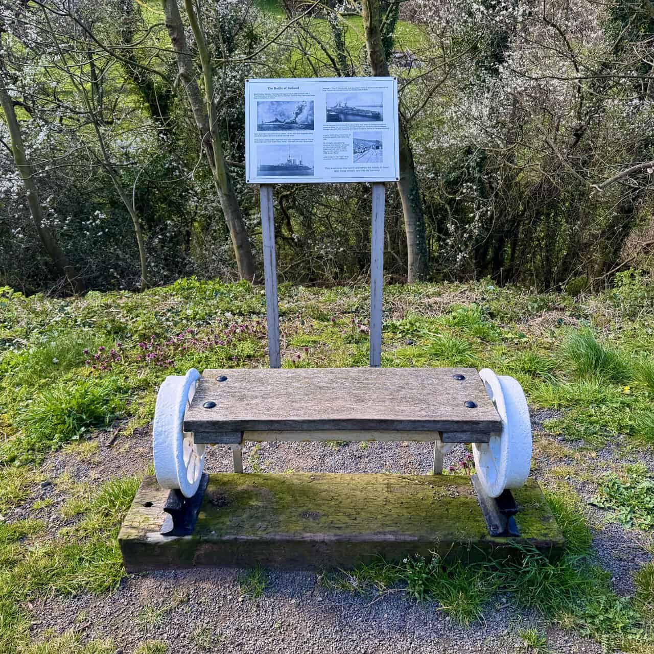
The information board makes a striking connection. The ironstone was shipped to the Jarrow yard of Charles Mark Palmer, who owned both the Grinkle Mine and the shipyard. It was at Palmer’s yard that HMS Queen Mary, a 27,000-ton battlecruiser, was launched in 1912. On Bank Holiday Monday 1916, she was sunk at the Battle of Jutland, the biggest naval engagement of the First World War, when her magazine was hit and she exploded. Tragically, 1,266 men died and only eighteen survived. It is highly probable that ironstone from Grinkle, carried along this very tramway through Dalehouse, was used to make the iron that built her.
ADVERTISEMENT
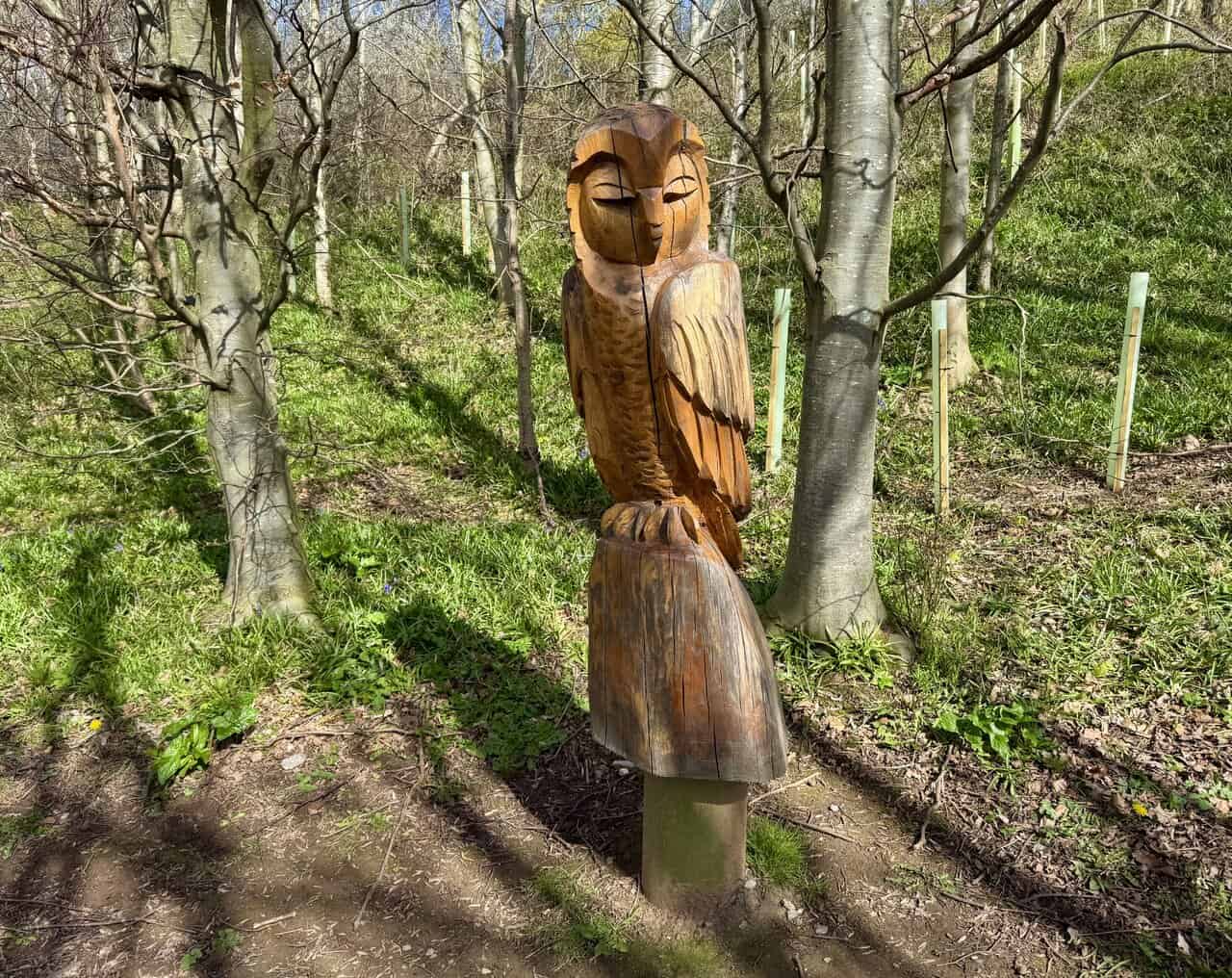
The former tramway leads me into Oakrigg Wood, a local nature reserve set in the valley between Dalehouse and Hinderwell. The wood takes its name from the abundance of native English oaks found here, and to these have been added many of the sixty-five different oak species that now grow in this country. A carved wooden owl stands among the young trees, perched on a stump with its eyes closed and its feathered wings folded, a fine piece of chainsaw sculpture in warm, honey-coloured wood.
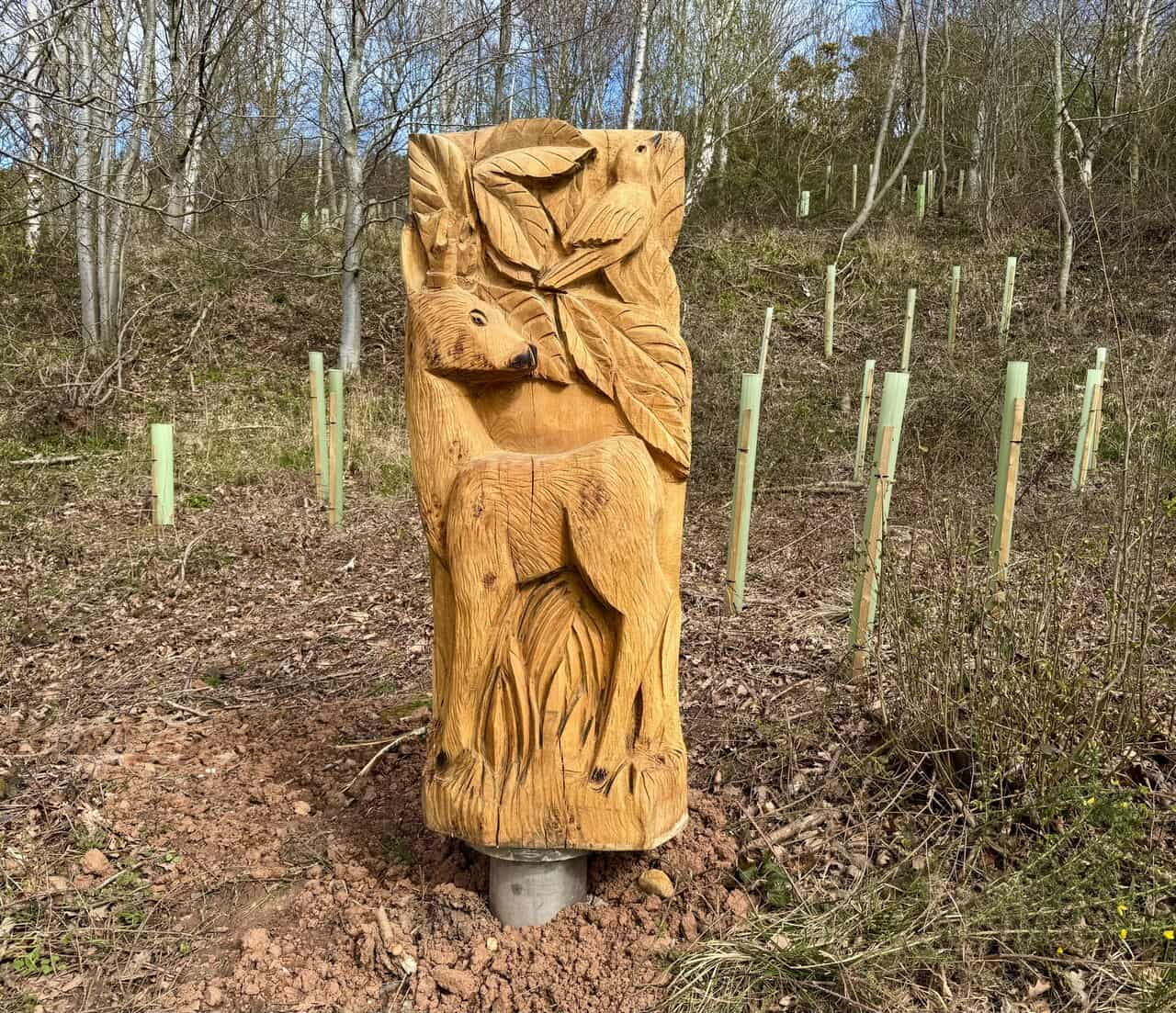
Further along the path I come across a second carving, this time a tall panel depicting a deer standing beneath broad leaves, with a small bird perched above. The detail in the carving is impressive, from the texture of the deer’s coat to the veins in the leaves. Alongside the native oaks, other exotic tree species gathered from the parks, gardens and cities of England have been planted here for the enjoyment and benefit of all.
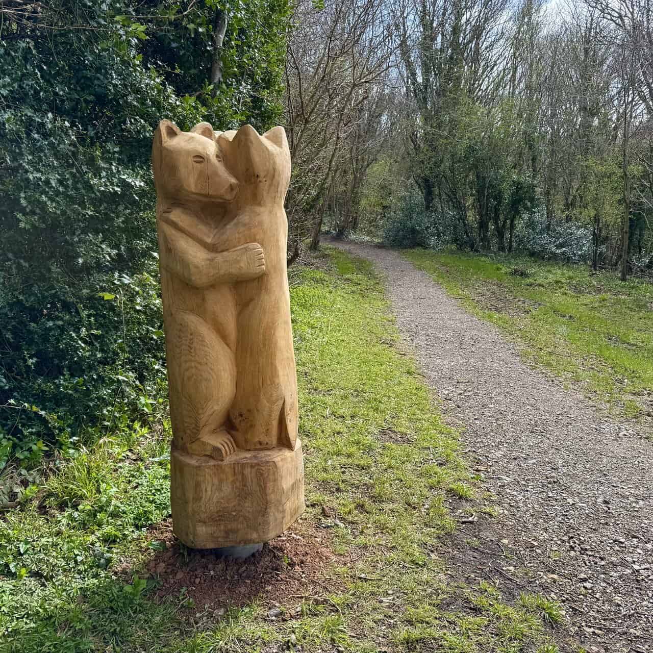
A third sculpture appears beside the path: two bears carved from a single trunk, standing upright and embracing one another. The path continues ahead through the trees, quiet and dappled with light. This stretch of the Runswick Bay walk is a welcome contrast to the exposed clifftops, a sheltered, green corridor that follows the valley floor.
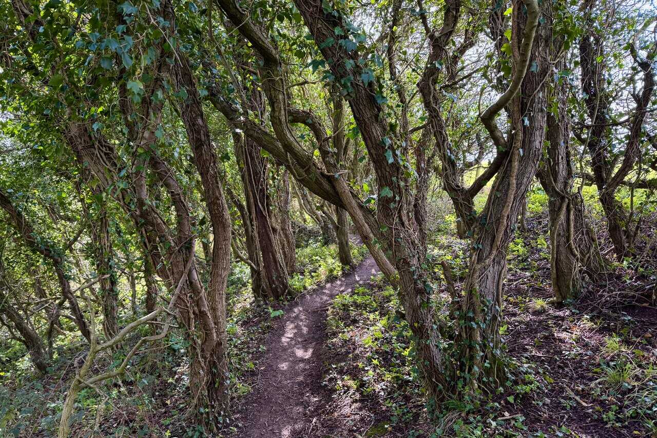
Leaving the nature reserve I continue heading south through woodland along a very narrow path. Twisted, gnarly trees lean in from both sides, their ivy-covered trunks and low branches forming a dense, natural tunnel overhead. The light filters through in patches, and the path ahead narrows to little more than a thread of bare earth winding between the roots. I’m now about three-quarters of the way round my this Runswick Bay walk.
ADVERTISEMENT
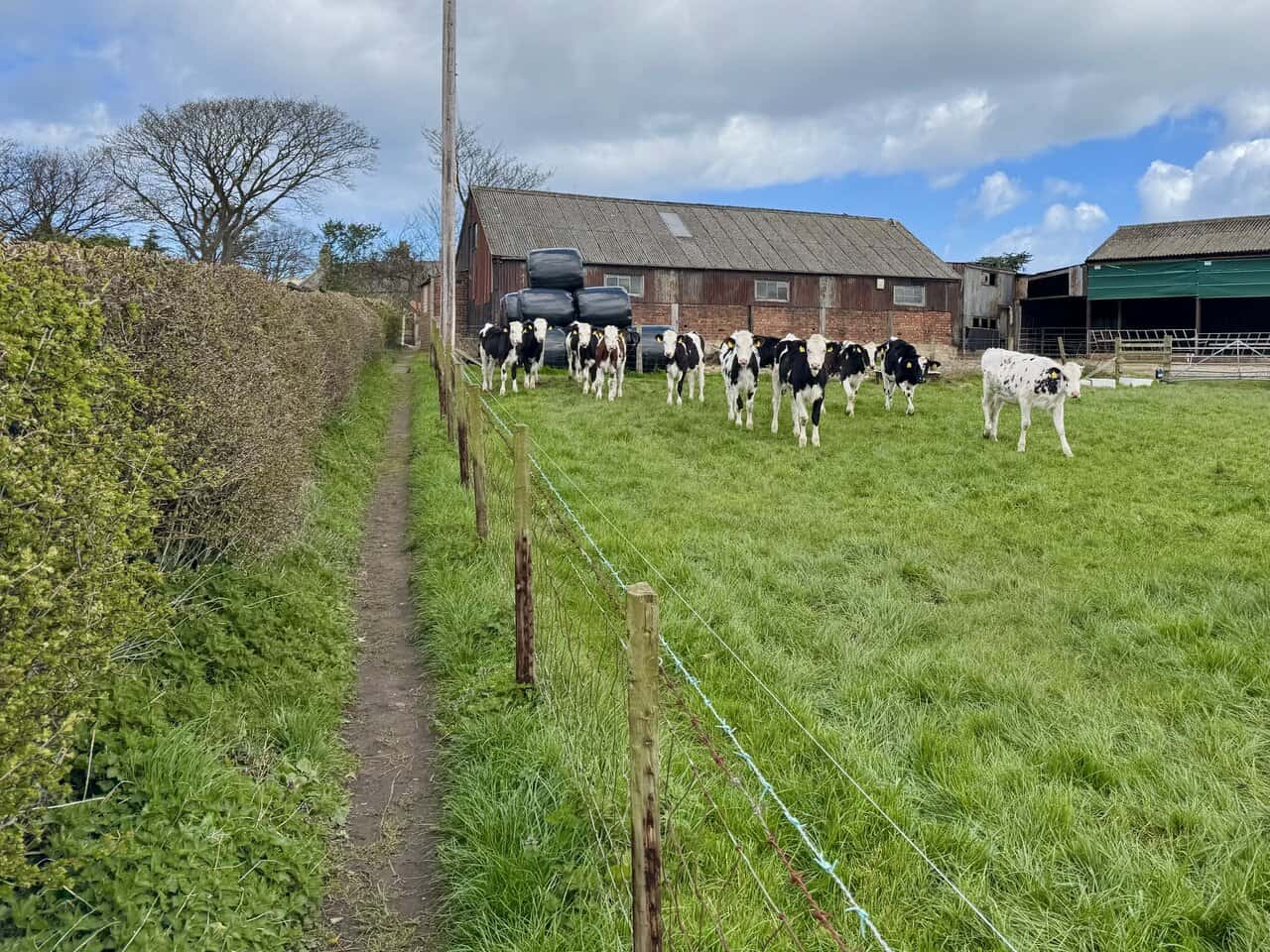
After my woodland walk I descend into a valley and cross Dales Beck before climbing up the other side towards Hinderwell. The path is narrow and enclosed, running between hedgerows and a small open field. A group of friendly young cows wander over to the fence to say hello as I pass.
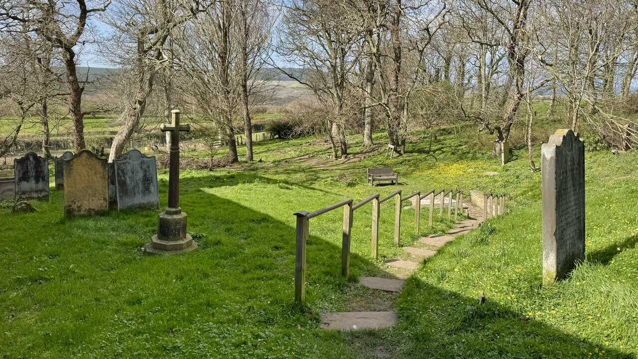
I arrive at St Hilda’s Church in Hinderwell, set in a peaceful churchyard dotted with old headstones and wildflowers. A large yew tree stands close to the building, its broad canopy spreading over the graves. The church is dedicated to St Hilda (c. 614–680), perhaps the most renowned female saint of Anglo-Saxon England. A grandniece of King Edwin of Northumbria, she was baptised by Saint Paulinus at York in 627 when she was thirteen years old.
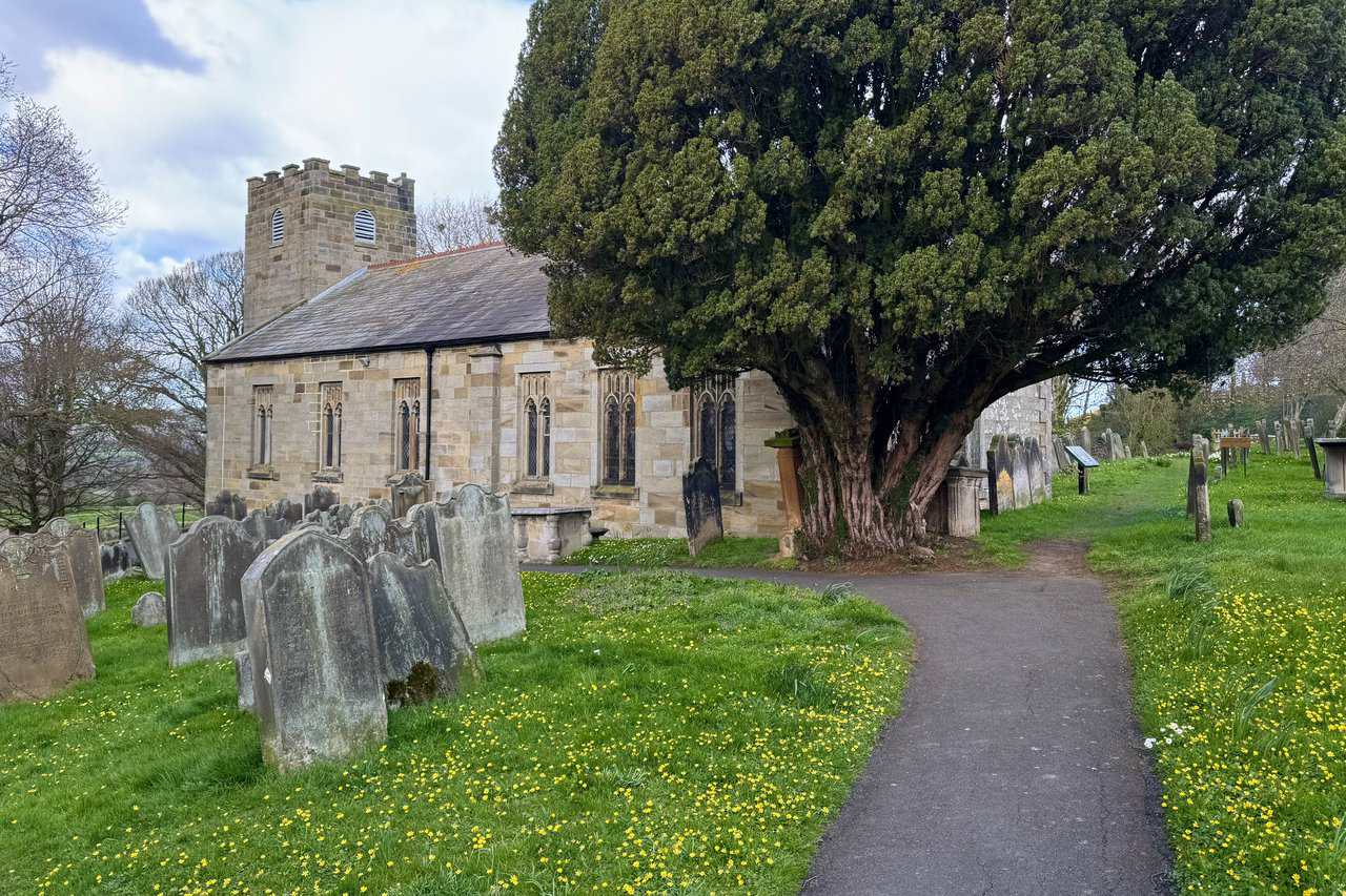
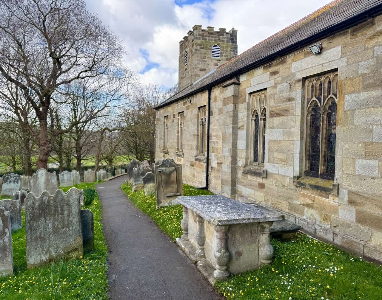
The path leads along the side of the church, passing weathered chest tombs and leaning headstones. The current building dates from 1773, a single rectangle of 67ft 6in by 28ft 6in with a tower at the west end that also serves as a porch. The tower was rebuilt in 1817, and in 1895 the six rectangular windows on each side were given gothic tracery within their original openings. An earlier church on this site probably dates from the twelfth century, but the Holy Well in the churchyard has much older origins still and probably gave its name to the village.
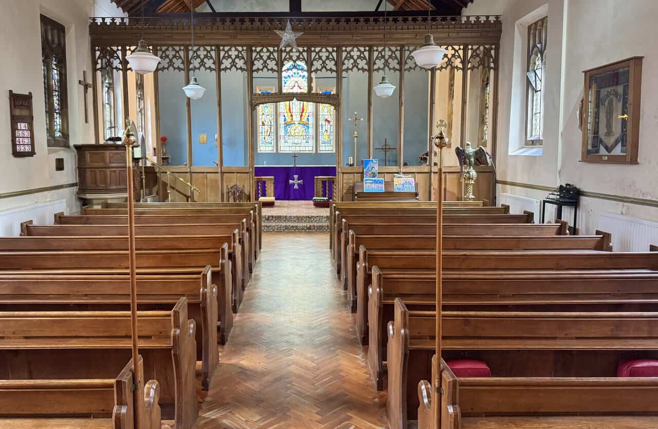
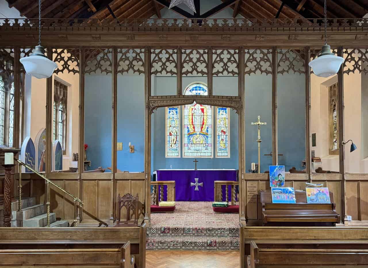
The church is open, so I step inside. Oak pews line either side of a herringbone-patterned floor, and the nave leads towards an ornate wooden rood screen with delicate carved tracery. Beyond it, the sanctuary is painted in a distinctive soft blue, and a colourful stained glass window fills the east end with light. St Hilda was a disciple of the great St Aidan of Lindisfarne and is most famous as the Abbess of Whitby Abbey and as an important figure at the Synod of Whitby in 663, which decided between the Roman and Celtic dates for Easter.
ADVERTISEMENT
A closer look at the rood screen reveals the quality of the woodwork, with its arched openings and carved gothic detail. St Hilda became known for her spiritual wisdom and her monastery for the calibre of its learning and its nuns. Saint Bede was enthusiastic in his praise of her as one of the greatest Englishwomen of all time. Amongst her monks was the herdsman Caedmon, the first English religious poet. She suffered from fever for the last six years of her life but continued to work until her death in 680, aged sixty-six. In her final year she established another monastery, fourteen miles from Whitby, at Hackness.
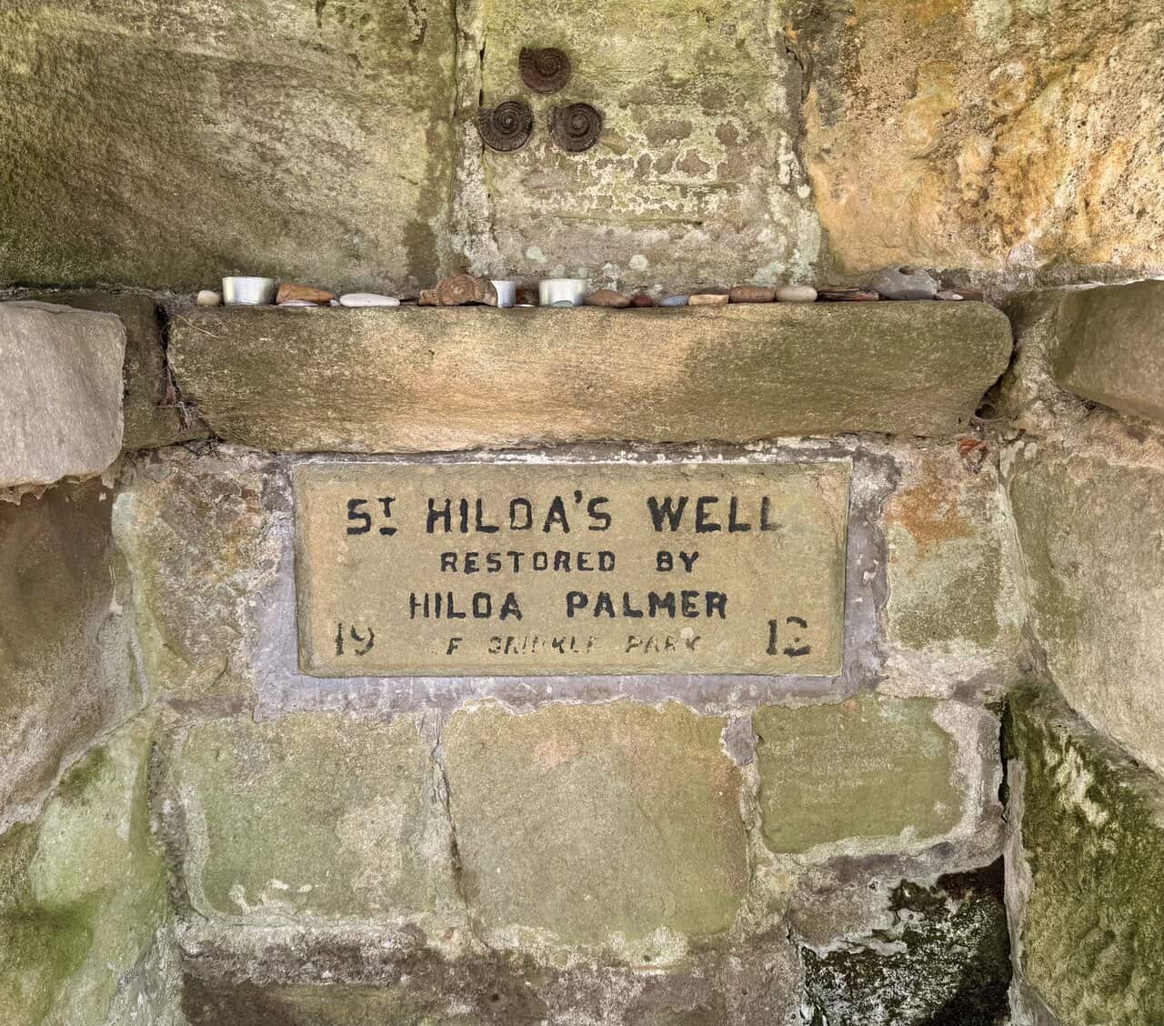
From the churchyard I follow a set of stone steps down the slope, past a stone cross and weathered headstones, towards St Hilda’s Well below. St Hilda is also said to be responsible for the ammonites often found along this coastal stretch, as they resemble curled-up headless snakes. According to legend she prayed for all the snakes of the neighbourhood to lose their heads, and for this reason ammonites are known locally as St Hilda’s Snakes. Seabirds flying over Whitby Abbey are even said to dip their wings in recognition of this miracle.
At the foot of the steps I find St Hilda’s Well, a small, stone-built structure with a heavy lintel and a plaque reading “St Hilda’s Well, Restored by Hilda Palmer of Grinkle Park, 1912.” The well is the only scheduled ancient monument in the parish and was once the sole water supply for the village. Its waters were said to have healing properties for eye diseases, and during the Middle Ages it became a place of pilgrimage. According to legend, St Hilda was asked to intercede in a drought whilst travelling through the parish. Her prayers were answered, and the spring which appeared has continued to bubble from the hillside to this day.
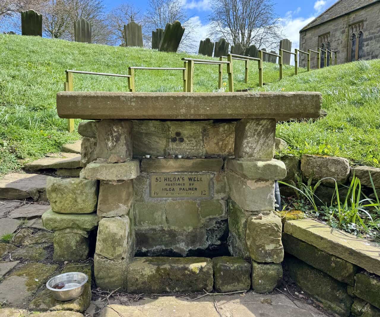
Small stones, shells and candles have been left on the ledge above the plaque, and three ammonite fossils are set into the stonework above. On Ascension Day, a custom known as Shaking Bottle Sunday was once held here, when local children would shake well water in a small bottle containing a stick of liquorice to make a flavoured drink. A commemorative open-air service is still held at the well each July. In 2015, St Hilda’s Way was launched from this spot, a forty-mile pilgrimage visiting all eight churches in the Esk Valley dedicated to St Hilda, plus two others, finishing at Whitby Abbey.
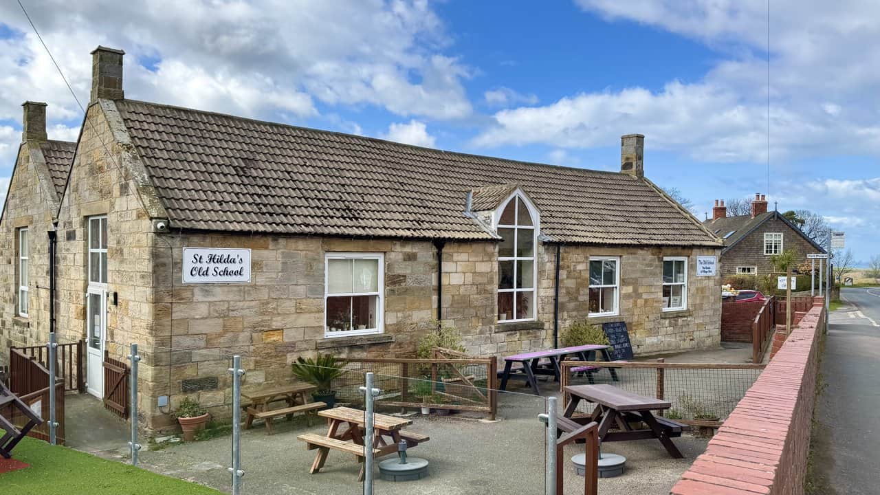
From the church I make my way through Hinderwell and pass St Hilda’s Old School, now a community tearoom and village hub. The single-storey sandstone building sits on the High Street with picnic benches outside in the old school yard, and it has a warm, welcoming feel about it. Run by volunteers, it serves home-cooked food and locally sourced produce, and also houses a small craft shop and artwork by local artists. It would be another good stop on this Runswick Bay walk, but I press on.
ADVERTISEMENT
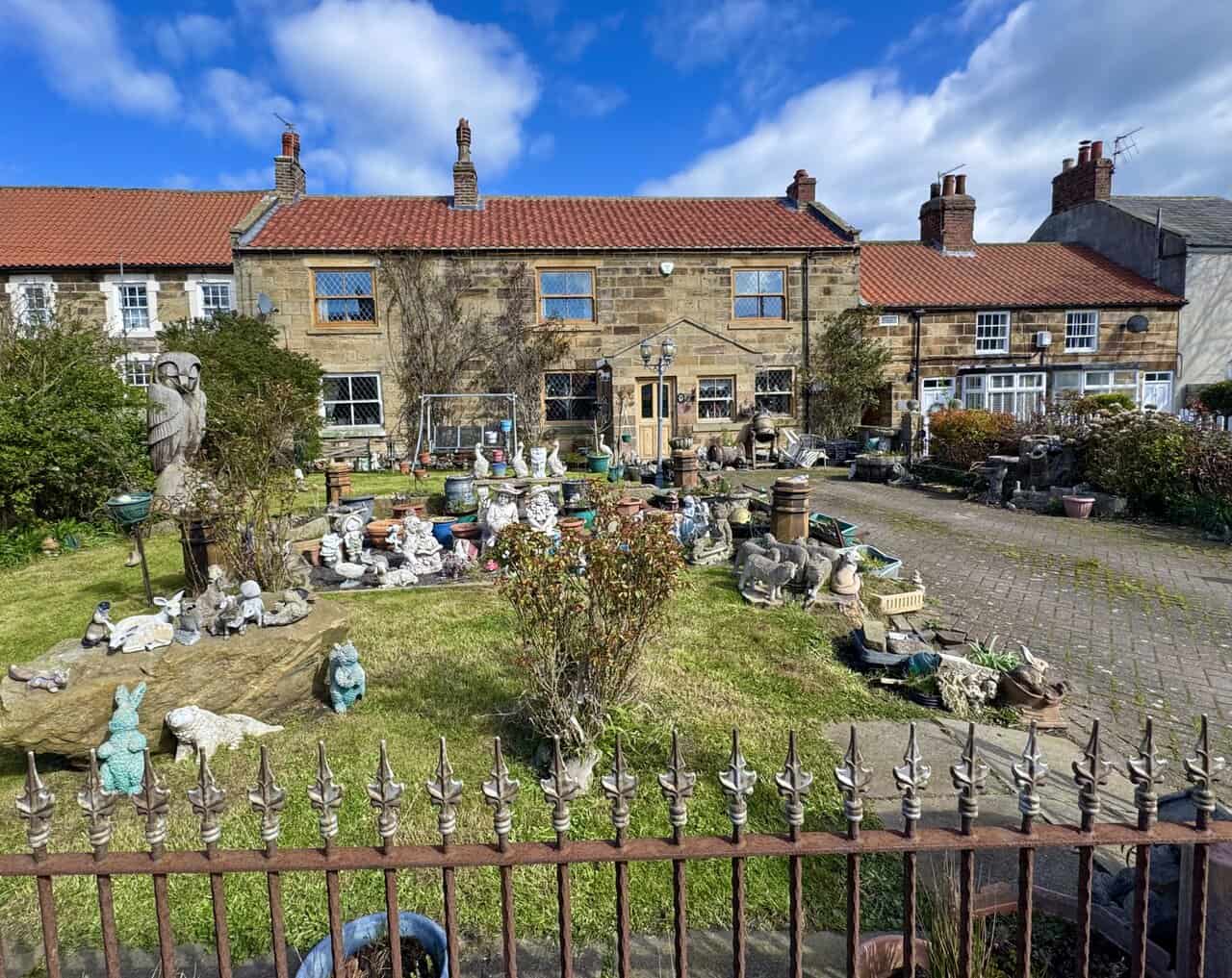
Walking through Hinderwell towards the far side of the village, I pass a sandstone cottage with leaded windows that stops me in my tracks. The front garden is packed with an extraordinary collection of ornaments, from gnomes and animal figures to plant pots, stone carvings and a large wooden owl standing guard on the left. Behind the iron railings it is a wonderfully eccentric display, and every inch of the garden seems to have something in it.
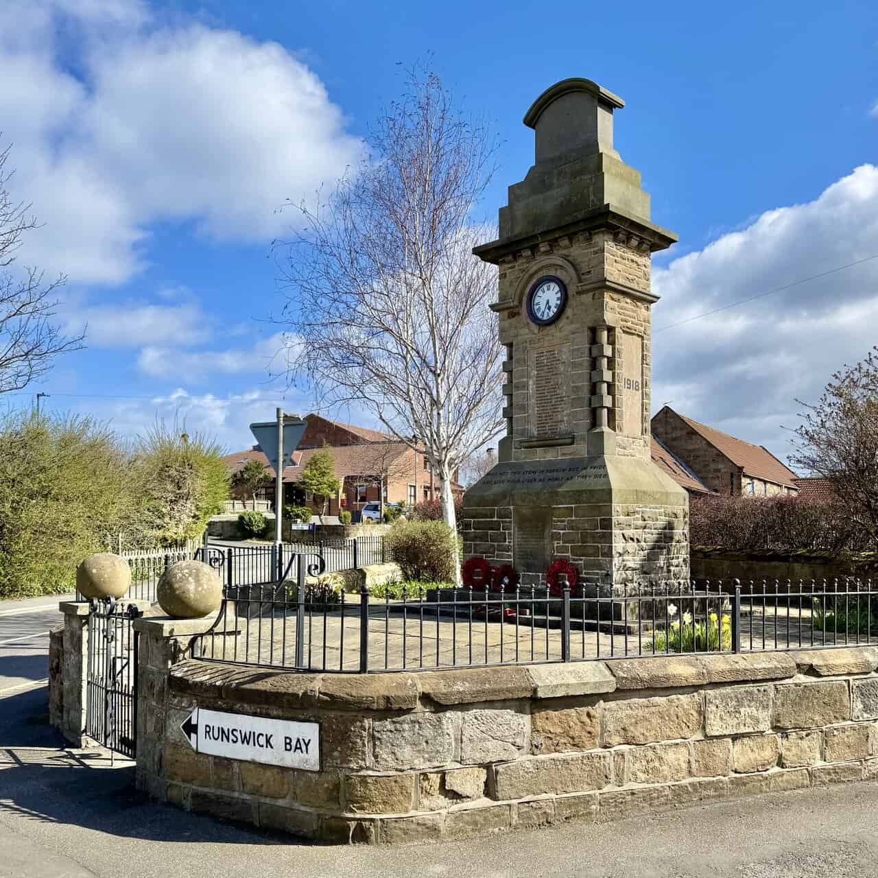
I am almost through Hinderwell now and reach the village war memorial, a Grade II listed sandstone clock tower standing at the junction where the road to Runswick Bay turns off to the left. Built by public subscription and unveiled in 1921, it commemorates the thirty-five men from Hinderwell, Port Mulgrave and Runswick who lost their lives in the two World Wars. Its inscription reads: “Pass not this stone in sorrow but in pride, and live your lives as nobly as they died.” The clock was added because the only one in the village at the time was inside the post office, and people waiting for the bus were damaging the shop front by climbing on the window sill to see the time. I take the road on the left, signposted Runswick Bay.
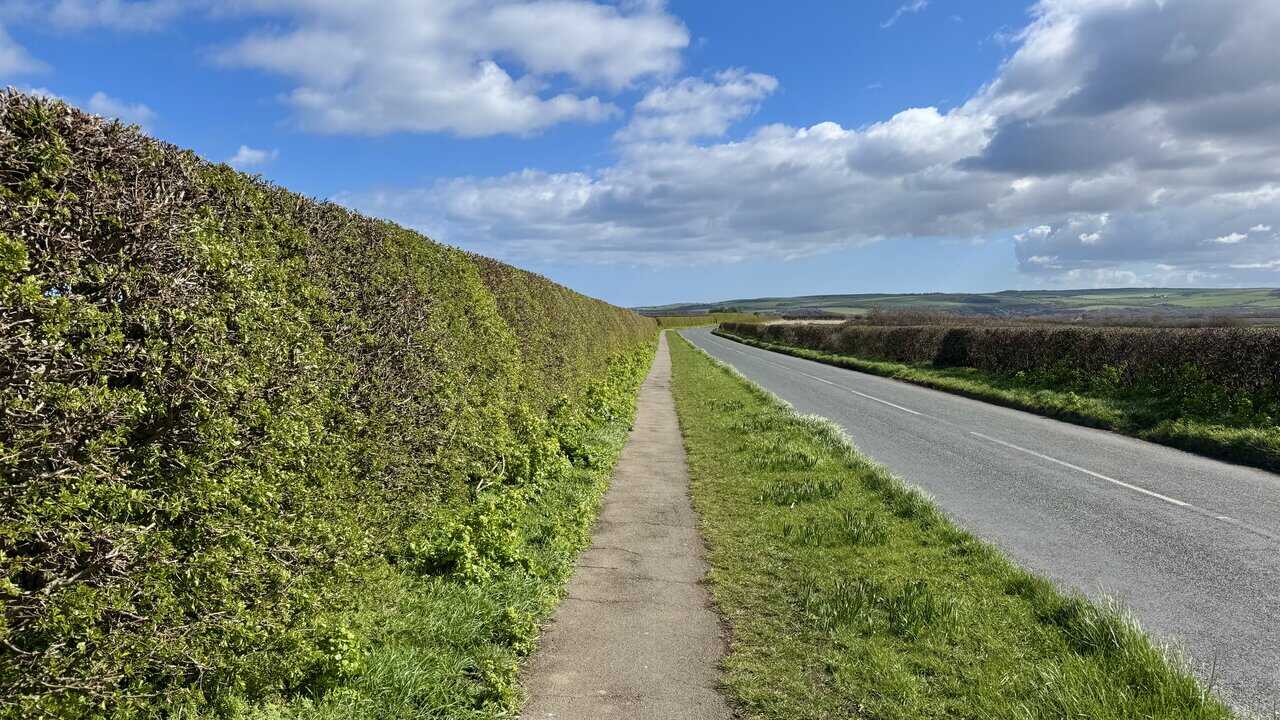
The final stretch of the Runswick Bay walk follows a narrow roadside footpath from Hinderwell, running between a tall hedge and the open road. The path is straight and level, with wide views across farmland to the moors in the distance. It is about a mile back to the car park at Runswick Bay, a pleasant and easy finish to a walk that has taken in fishing villages, industrial heritage, clifftop drama and a good deal of history along the way.
ADVERTISEMENT