ADVERTISEMENT
Complete the Cleveland 4 Peaks Challenge Across the Stunning North York Moors
Begin your Cleveland 4 Peaks walk at the Forestry England Clay Bank car park, located beside the B1257 at the top of Clay Bank, between Great Broughton and Chop Gate. From the car park, turn left and walk alongside the road in the direction of Helmsley. After a short distance, cross the road and turn right onto the public footpath signposted Cleveland Way to Carlton Bank. Follow the stone steps as the trail climbs steeply uphill. The path alternates between large stone slabs and cobbled sections, zigzagging its way up the hillside. As you reach the top, the ground levels out, marking your arrival at White Hill, the first peak of your Cleveland 4 Peaks challenge.
As you follow the level path across the top of White Hill, you’ll pass two raised mounds on the right, marking its highest points at approximately 398 metres. Continue along the Cleveland Way as it descends towards a striking rocky outcrop known as Wain Stones. Follow the path through the rocks, using the acorn-symbol waymarkers to stay on the Cleveland Way. Once through the boulders, continue along the stone path as it descends to the valley floor. You have now completed both the ascent and descent of White Hill, the first of your Cleveland 4 Peaks.
At the bottom of the hill, stay on the Cleveland Way and begin your ascent of Cold Moor, the second peak in your Cleveland 4 Peaks challenge. Follow the cobbled stone path as it climbs steadily upwards. The path leads to a level plateau, marking the summit of Cold Moor, which stands at 402 metres. From here, continue along the stone path and begin your descent into the valley below, completing the ascent and descent of your second Cleveland 4 Peaks summit.

ADVERTISEMENT
At the base of the hill, follow the Cleveland Way towards Carlton Bank. After the fourth Cleveland Way signpost, the path splits. Take the left-hand fork and follow the stone slabbed path uphill to begin your climb up Cringle Moor. As you ascend, the path eventually levels out. A small, narrow footpath on your left leads across the moorland to a large pile of stones, marking the highest point of Cringle Moor. Marked on the map as Drake Howe, this cairn stands at 432 metres, making it the highest of your Cleveland 4 Peaks.
Retrace your steps along the moorland path, then turn left to continue along the Cleveland Way. The stone path curves around to a viewpoint featuring a stone seat and a toposcope. From here, follow the cobbled path downhill, keeping the dry stone wall to your right. The descent is straightforward—continue all the way to the valley floor, completing the third of your Cleveland 4 Peaks.
Stay on the Cleveland Way as it skirts the edge of a woodland. In front of a section of trees, you will notice three benches. At this point, you have the option to take a short detour along a grassy path on your right, leading to Green Bank, where a modern stone semicircle and benches offer stunning views towards Teesside. Retrace your steps and turn right to rejoin the Cleveland Way, following the path through the woods. As you pass the café at Lordstones, continue straight ahead. When the trail splits, take the left-hand path, go through a gate, and cross the road. Follow the footpath ahead, signposted Cleveland Way to Huthwaite Green.
At the next junction, continue straight on, following the Cleveland Way as it begins the ascent of Carlton Bank, the fourth and final peak of your Cleveland 4 Peaks challenge. Climb the stone steps all the way to the top, where you’ll reach a triangulation pillar and an ancient stone post. Standing at 408 metres, this marks the highest point of Carlton Bank.

ADVERTISEMENT
From the summit, turn right and follow the narrow path downhill. The descent is initially very steep and can be slippery, so take care. As you continue, the gradient eases, and you will pass a large area of grey land, a former quarry. After the quarry, continue a little further downhill to meet another path—turn right here. You have now completed the ascent and descent of Carlton Bank, the final peak of your Cleveland 4 Peaks challenge.
At the bottom, follow the path alongside the fence until it meets the road at Lordstones. Walk straight ahead along the road for a short distance before turning left, following the signposted Cleveland Way to Clay Bank. Continue along the path past the café at Lordstones and through the woodland once more. However, instead of reascending Cringle Moor, take the left-hand footpath into the trees. When this path splits into three, take the middle path. Follow it as it gradually ascends, eventually emerging into open countryside.
The path now becomes a bridleway. Continue straight ahead for almost a mile, avoiding any left or right turns. This section is relatively flat, winding around the slopes of Kirby Bank. Eventually, the bridleway rejoins the Cleveland Way, retracing your earlier steps between Cringle Moor and Cold Moor. Walk briefly along this familiar path, then take a left at the fork, following the sign for Great Broughton. Pass two large concrete posts, descend into a dip, then climb back up and walk through a gate. Continue straight ahead along the dry stone wall.
Follow the path along the inside edge of the woods for just under a mile. The path then begins to rise again, skirting the left-hand side of Wain Stones, which will be visible above you. Continue along the woodland track, passing the steep slopes of White Hill, also on your right. After about a mile, the track gradually descends to rejoin the Cleveland Way. From here, follow the trail downhill towards the B1257. Turn left and walk alongside the road back to Clay Bank car park, where your Cleveland 4 Peaks adventure concludes.
Cleveland 4 Peaks: Maps and Tools
Visit either the OS Maps website or the Outdooractive website to view this walking route in greater detail. Both platforms offer a range of features, including the ability to print the route, download it to your device, and export the route as a GPX file. You can also watch a 3D fly-over and share the route on social media. Additionally, this page includes a printable version of the walk in PDF format. Plus there is a supporting video, available for you to watch on YouTube.
Cleveland 4 Peaks Walk: Distance, Duration, Statistics
Distance: 9 miles
Distance: 14 kilometres
Duration: 4¾ hours
Ascent: 2087 feet
Ascent: 636 metres
Type: Circular walk

ADVERTISEMENT
Recommended Ordnance Survey Map
The best map to use on this walk is the Ordnance Survey map of the North York Moors Western Area, reference OS Explorer OL26, scale 1:25,000. It clearly displays footpaths, rights of way, open access land and vegetation on the ground, making it ideal for walking, running and hiking. The map can be purchased from Amazon in either a standard, paper version or a weatherproof, laminated version, as shown below.
North York Moors Walking Guidebooks
The North York Moors, by Paddy Dillon, describes 50 walks of 4 to 14 miles across the Tabular Hills, Hambleton Hills, Cleveland Hills, high moors and Cleveland coast, plus the Lyke Wake Walk in four stages, with Ordnance Survey mapping and notes on transport and refreshments.
North York Moors Short Walks Made Easy, published by Ordnance Survey, brings together 10 accessible routes of 2.5 to 4.5 miles, each taking around a couple of hours, ideal for families or anyone short on time. Both books can be purchased from Amazon, as shown below.
Walking the North York Moors
The North York Moors, by Paddy Dillon, a Cicerone guidebook of 50 walks throughout the National Park
About the Cleveland Hills
The Cleveland Hills are a range of hills on the north-western edge of the North York Moors in North Yorkshire, overlooking Teesside. They are entirely within the North York Moors National Park. A section of the 110-mile Cleveland Way National Trail runs along these hills, as well as part of Wainwright’s Coast to Coast Walk. The hills rise steeply from the flat land of the Tees Valley, creating striking landmarks like Roseberry Topping, a distinctive cone-shaped peak near Great Ayton.
How the Cleveland Hills Were Formed
The Cleveland Hills are made up of layers of rock that were formed during the Jurassic period, over 145 million years ago. The hills stand tall above the lower land to the north and west, which is mostly covered by soft mudstone, hidden beneath thick layers of material left behind by glaciers during the last Ice Age.
Most of the rock in these hills is a mix of sandstone, mudstone, and siltstone, but some layers also contain limestone and ironstone. In the past, the Cleveland Ironstone Formation was mined to support the iron and steel industry. The plateau of the hills is mostly made of sandstone, while the peak of Roseberry Topping is a small, separate piece of rock that has been left behind due to erosion.
A type of volcanic rock, known as the Cleveland Dyke, runs through the hills, forming Langbaurgh Ridge and Cliff Ridge, just south of Roseberry Topping. Cliff Rigg Quarry has been used to mine this tough rock for road-building materials.
In some areas, gravel and sand left by melting glaciers can be found, especially around Kildale. On the flat plateau, peat has built up over time. The hillsides are unstable in places, leading to landslides, particularly on the western slopes and in Raisdale to the south.
History of the Cleveland Hills
People have lived in and around the Cleveland Hills for thousands of years. Many ancient burial mounds (tumuli) and stone circles dating back to the Bronze Age can still be found today. There are also numerous cairns (rock piles), some very old and others more recent.
Excavations in the area have uncovered hundreds of flint arrowheads from the Mesolithic and Neolithic periods (the Middle and New Stone Ages), showing that people were actively hunting and living in this landscape thousands of years ago.
Mining and Industry in the Cleveland Hills
In 1850, a man named John Marley discovered ironstone in the Eston Hills, which are an extension of the Cleveland Hills. This led to large-scale mining and helped fuel the rapid growth of Middlesbrough into an industrial centre.
By the 1870s, the area was producing huge amounts of steel, and mining expanded to extract coal, alum, jet, shale, and potash. Quarries were also used to collect sandstone and limestone for building and industry. Although mining has long since stopped, the remains of old mines and quarries can still be seen in the landscape today.
Cleveland 4 Peaks Walk: My Photos
I begin my Cleveland 4 Peaks walk from the Forestry England Clay Bank car park. From the main road at the top of Clay Bank, I pick up the Cleveland Way and immediately start the steep ascent of White Hill. With no gradual incline to ease into the climb, there’s little chance to warm up before the challenge begins.

ADVERTISEMENT
The path up White Hill is well-maintained, consisting of large cobblestones and stone slabs. Its clear and structured layout makes navigation straightforward, though the incline demands effort.

As I climb, I pause occasionally to look back and admire the views towards Urra Moor. On the moor, at Round Hill, stands a triangulation pillar at 454 metres—the highest point in the North York Moors. However, from my current vantage point, it remains hidden, set slightly further back on the hill.

ADVERTISEMENT
Reaching the summit of White Hill, I tick off the first peak of my Cleveland 4 Peaks challenge. Looking east, I spot the car park beside the B1257, where my journey began. Below me stretches Greenhow Plantation, a dense forest lying to the north of Urra Moor.

To the north, I take in the distinctive outline of Roseberry Topping, a well-known landmark. South-west of it, the village of Great Ayton is clearly visible.

ADVERTISEMENT
Also looking north, I identify the villages of Great Broughton and Stokesley, with further-reaching views extending towards Middlesbrough, Billingham, Hartlepool, and Redcar.

The path across White Hill flattens out for about half a mile—a welcome break after the steep ascent. I take the opportunity to catch my breath and soak in the scenery.

ADVERTISEMENT
At the western end of White Hill, I arrive at Wain Stones, a striking rocky outcrop. These huge sandstone boulders, shaped by thousands of years of wind and rain erosion, create a dramatic natural feature.

From Wain Stones, the views are spectacular, stretching in all directions. To the west, I spot my next challenge—Cold Moor—rising about half a mile away.

ADVERTISEMENT
Looking south from Wain Stones, I gaze down into Bilsdale, the valley flanked by Urra Moor to the east and Cold Moor to the west.

Navigating through Wain Stones, I follow a narrow path marked with acorn symbols, the official waymarkers of the Cleveland Way and other National Trails.

Descending from Wain Stones, I continue along the Cleveland Way for a short stretch before beginning my next climb—Cold Moor.

ADVERTISEMENT
Once again, the ascent is steep but well-constructed, with stone steps, large cobbles, and paving slabs designed to prevent erosion. Though sturdy, the climb is another challenging section of the Cleveland 4 Peaks route.

At 402 metres, Cold Moor marks the second peak of my Cleveland 4 Peaks challenge. From the summit, I enjoy far-reaching views north towards Great Broughton, Kirkby, and Stokesley, with the Terry Dicken Business Park visible to the south of Stokesley. In the distance, Middlesbrough, Billingham, and Redcar stretch towards the horizon.

A brief, level section across the top of Cold Moor provides a short-lived respite, unlike the longer flat stretch on White Hill. Before long, the descent begins.

ADVERTISEMENT
As I descend Cold Moor along the Cleveland Way, I easily spot my next goal—Cringle Moor—standing about a mile to the west.

Following the descent, I enjoy an easier stretch across fields, where the well-signposted Cleveland Way guides me ever closer to Cringle Moor.
After crossing the fields and passing several Cleveland Way signposts, the path splits. I take the left-hand route, following a stone pathway that marks the beginning of the climb up Cringle Moor.

ADVERTISEMENT
Not long into the ascent, I am already rewarded with a spectacular view towards Roseberry Topping, which sits on the horizon at the centre of my photo.
As I push onwards, another well-maintained path helps ease the steep climb up Cringle Moor. Huffing and puffing, I press on, knowing the next peak is within reach.

At 432 metres, Cringle Moor is the third peak of my Cleveland 4 Peaks challenge. Its highest point isn’t directly on the Cleveland Way but is marked by a large pile of stones at Drake Howe, slightly to the south of the main path. A narrow track leads to this summit landmark, as indicated on Ordnance Survey maps.

ADVERTISEMENT
After visiting Drake Howe, I return to the Cleveland Way and glance back at Cold Moor, where I stood earlier.

The Cleveland Way across Cringle Moor is mostly flat, offering a chance to recover and enjoy the views. The path curves right above the steep slopes of Kirby Bank, leading to an outstanding viewpoint, marked by a visible stone bench.

At the viewpoint, a stone bench, a toposcope, and an older stone pillar enhance the experience. The panoramic views stretch across Middlesbrough, Billingham, Redcar, Hartlepool, and out towards the North Sea.

From here, I also take in Great Broughton, Kirkby, Stokesley, and Roseberry Topping—an incredible vista that showcases the landscape of the Cleveland 4 Peaks challenge.

ADVERTISEMENT
Leaving the viewpoint, I begin my descent along the cobbled path beside a dry stone wall. In the distance, about 1.3 miles away, I spot my final target—Carlton Moor.

The path down from Cringle Moor levels out as it follows the dry stone wall along the woodland’s edge, leading towards Lordstones.

Before reaching Lordstones, I detour to Green Bank, where a semi-circle of stones stands. Though it appears ancient, this modern feature was actually erected around 2013.

One of Green Bank’s best features is the pair of benches positioned on the edge of the hillside, offering stunning views towards Teesside.

ADVERTISEMENT
Back on the Cleveland Way, I arrive at Lordstones Country Park and take a well-earned break at the café. Having visited several times, I always find it warm, welcoming, and the perfect spot for a coffee.

Refreshed, I continue along the Cleveland Way towards Huthwaite Green, which marks the start of my ascent to Carlton Moor.

As I climb, I take in breathtaking views of Teesside and the North Sea.

Reaching the summit of Carlton Moor, I complete the fourth and final peak of my Cleveland 4 Peaks challenge. At 408 metres, the top is marked by a triangulation pillar and an older stone post.
ADVERTISEMENT
To the west, I admire the tree-covered Whorl Hill, with the village of Faceby nestled below it.

Looking down, I see Carlton in Cleveland. My descent follows a narrow, steep path, which can be slippery in wet conditions. The route zigzags towards a disused quarry, where the gradient eases.

Beyond the quarry, I follow a path leading back to the road near Lordstones before rejoining the Cleveland Way through Lordstones Country Park.

From Lordstones, I take a bridleway that skirts the northern slopes of Cringle Moor, following the contour lines with minimal elevation changes. However, wet conditions make this section muddy and slippery.

ADVERTISEMENT
As I continue along Kirby Bank, I get a view of Cold Moor’s summit, where I stood earlier. This time, I follow the path around its northern side rather than ascending.

The route then winds along the slopes of Broughton Bank, overlooking Broughton Banks Farm and the village of Great Broughton.

With a dry stone wall on my right and the steep slopes of Cold Moor above, I navigate through Broughton Plantation’s woodland edge.

After roughly 1½ miles, a familiar sight greets me—Urra Moor and the car park beside the B1257.
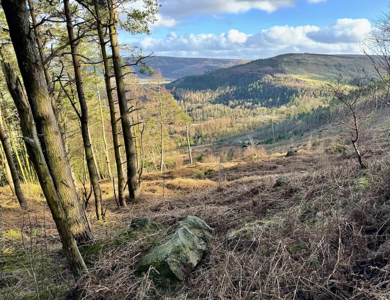
The final stretch follows a route beneath the steep northern slopes of White Hill.

ADVERTISEMENT
As the path begins to descend, I know I am nearing the end of my Cleveland 4 Peaks walk.

Rejoining the Cleveland Way, I descend the final steps to the main road. A short walk along the roadside brings me back to the car park, where my Cleveland 4 Peaks adventure comes to an end.

ADVERTISEMENT