ADVERTISEMENT
Enjoy Panoramic Views and Peaceful Trails on the Fremington Edge Walk
To begin your Fremington Edge walk, start in the centre of Reeth, where you’ll find plenty of parking. You can park on the large cobbled area in front of the pubs or use the additional parking spots around the village green. From there, head downhill on the B6270 as if you are leaving the village for Leyburn and Richmond. Soon, you’ll cross Arkle Beck via Reeth Bridge. After crossing, continue along the road into Fremington, where a footpath runs beside the road, making this section easy-going.
When you reach Fremington, turn left onto a tarmac lane signposted to High Fremington. The lane climbs steeply uphill, passing Hobson’s Cottage on your left. Continue as the lane bends to the right, taking you past Briar Cottage and Brambles. Walk straight on until the lane curves left, passing between Frog House and Stable Barn. Keep following the lane uphill, ignoring the footpath to your left, signposted to Arkendale, and proceed through Intake Wood.
After about half a mile (0.8 kilometres) of uphill walking, you will arrive at the driveway leading to White House. At this point, the tarmac lane turns into a stone track. Continue following the signpost for Hurst. Shortly after, you will see a public footpath sign pointing to the right, offering a short detour to explore the disused chert quarries, should you wish. Otherwise, go through the gate and continue up the stone track. When the track widens and splits into two, take the left fork.

ADVERTISEMENT
As you follow the left fork, you will see a sign pointing to Fremington Edge and Hurst. However, take the grassy path to your left, passing a bench dedicated to Peter and Judith on your right. The path then leads across Fremington Edge. Enjoy the stunning views as you hike this section, staying close to the edge for over 1½ miles (2.4 kilometres). Eventually, you will reach a large, cone-shaped cairn at Fell End, marking the north-western end of Fremington Edge.
From the cairn, follow a narrow grassy path for about 150 metres (492 feet) away from the edge until you meet a bridleway indicated by a wooden post. Turn left onto the bridleway and begin your descent. As you head downhill, you’ll pass a series of small stone piles and another wooden post, which will guide your way. The bridleway zigzags steeply downhill through an area of disused lead mines, offering a fascinating and memorable part of your Fremington Edge walk.
Upon reaching a dry stone wall, turn left through the gate and follow the signpost for Langthwaite. A grassy track will take you downhill between two dry stone walls, leading you to Storthwaite Hall, which is a farmhouse. At the farmhouse, turn left and follow the bridleway signposted for Raw Croft Footbridge. As you descend past the farmhouse, go through a gate and cross two large fields heading towards Arkle Beck. Go through another gate and turn left onto a stone track heading uphill towards Heggs House.

ADVERTISEMENT
Pass the rear of Heggs House and continue on the bridleway uphill. Just before reaching a gate at the top, take the path to your right. This narrow path runs beside a dry stone wall and follows the hillside for almost three-quarters of a mile (1.2 kilometres), passing behind Castle Farm. Keep following the path by the side of the dry stone wall downhill into a wooded area. After about a quarter of a mile (400 metres), you’ll reach a second path. Continue straight forward on the bridleway, staying close to the dry stone wall, and follow this path for over a mile (1.6 kilometres), ignoring any side trails along the way.
Finally, the path will lead you to a tarmac lane just above High Fremington, where you were earlier. Turn right, then almost immediately take a narrow path on your right, leading downhill into High Fremington. Once on the road, turn right and continue through a gate onto a public footpath. This path will take you across fields, leading you back to Reeth Bridge. Cross the bridge and follow the road back into Reeth, where you will conclude your Fremington Edge walk.
Fremington Edge Walk: Maps and Tools
Visit either the OS Maps website or the Outdooractive website to view this walking route in greater detail. Both platforms offer a range of features, including the ability to print the route, download it to your device, and export the route as a GPX file. You can also watch a 3D fly-over and share the route on social media. Additionally, this page includes a printable version of the walk in PDF format. Plus there is a supporting video, available for you to watch on YouTube.
Fremington Edge Walk: Distance, Duration, Statistics
Distance: 7½ miles
Distance: 12¼ kilometres
Duration: 4 hours
Ascent: 1463 feet
Ascent: 446 metres
Type: Circular walk

ADVERTISEMENT
Recommended Ordnance Survey Map
The best map to use on this walk is the Ordnance Survey map of the Yorkshire Dales Northern & Central Area, reference OS Explorer OL30, scale 1:25,000. It clearly displays footpaths, rights of way, open access land and vegetation on the ground, making it ideal for walking, running and hiking. The map can be purchased from Amazon in either a standard, paper version or a weatherproof, laminated version, as shown below.
Standard Version
Yorkshire Dales Walking Guidebooks
Walking in the Yorkshire Dales: North and East, by Dennis Kelsall, describes 43 circular day walks of 3 to 12 miles across the Howgills, Mallerstang, Swaledale, Wensleydale, Coverdale and Nidderdale, with Ordnance Survey mapping and notes on parking and refreshments.
15 Short Walks in the Yorkshire Dales, by Jonathan and Lesley Williams, covers the area around Sedbergh, Kirkby Lonsdale and Ingleton. Its 15 routes of 1 to 7 miles each take under three hours, ideal for families or a relaxed half day out. Both books can be purchased from Amazon, as shown below.
Walking the Yorkshire Dales
About Fremington Edge
Fremington Edge is a striking 3-mile (4.8-kilometre) escarpment situated north of Reeth, in Swaledale, within the Yorkshire Dales National Park. It stretches from the north-west to the south-east, reaching Fell End in the north-west, about half a mile (0.8 kilometres) east of Slei Gill, and extending to Reels Head at its south-eastern end. The escarpment overlooks the Arkengarthdale valley in its north-western part and the junction of Arkengarthdale and Swaledale in the south-east.
Related Walk: Similar to the Fremington Edge Walk
Discover stunning views on a longer Fremington Edge walk in the Yorkshire Dales
Fremington Edge was formed after the last Ice Age, when meltwater from retreating glaciers caused a landslip, revealing the rocky outcrops that give it its rugged appearance. The escarpment still bears traces of an Iron Age fort and a settlement that predates the arrival of the Anglo-Saxons in the 8th century. Scattered across the area are remnants of old lead and chert mines, with numerous disused shafts and spoil heaps. The chert once mined here was transported by lorry to Staffordshire, where it was used to manufacture china and porcelain.
Fremington Edge Walk: My Photos
Before beginning my Fremington Edge walk, I take a moment to explore the village of Reeth. It’s a lovely spot with plenty to offer, including pubs, shops, bakeries, cafés, and guest houses, all centred around or near the large village green. Located 11 miles (18 kilometres) west of Richmond, Reeth lies within the civil parish of Reeth, Fremington, and Healaugh. As the principal settlement of Upper Swaledale, it’s a popular destination for both tourists and walkers.

ADVERTISEMENT
Reeth is positioned at the meeting point of Swaledale and Arkengarthdale. Just to the south-east, Arkle Beck joins the River Swale near Grinton. The village is surrounded by the fells, including Harkerside Moor, Calver Hill, and Fremington Edge, the latter shown in this picture. Reeth is also a stop along Alfred Wainwright’s Coast to Coast Walk, a well-known long-distance path stretching from Saint Bees to Robin Hood’s Bay.

Standing on the village green is the Reeth Evangelical Congregational Church. Originally built around 1783 by Rev David Bradberry for a congregation of Protestant Dissenters, the church may have been adapted from an earlier structure. Within 70 years, it had fallen into disrepair. In 1794, Bradberry gifted the building to the congregation for a nominal fee. The first recorded baptism took place in 1787 under the ministry of George Cooke, giving rise to the name ‘Cooke’s chapel’.
During the early 1800s, the area experienced economic and social decline, which affected both the village and the church. However, in 1835, Thomas Colledge led a revival of the church. By 1866, the original structure was deemed unsafe and was demolished. A new church, designed by a Darlington architect, was built and opened in 1868. Further improvements followed, including the installation of the village clock in 1903 and the enlargement of the Sunday School in 1912.

ADVERTISEMENT
Reeth’s war memorial is an obelisk that stands on the village green. It was unveiled in 1925 to commemorate the men from the parishes of Grinton, Marrick, and Reeth who lost their lives in both the First World War (1914-1918) and the Second World War (1939-1945). The memorial, mounted on a two-step plinth, stands approximately four metres tall and is surrounded by metal railings supported by stone posts. Three tablets are affixed to the obelisk, listing 18 names from the First World War and 10 from the Second World War. No survivors are recorded.

Leaving the village of Reeth behind, I cross Reeth Bridge, which carries the B6270, the main road through Swaledale. The bridge spans Arkle Beck, which flows southwards to join the River Swale near Grinton.

ADVERTISEMENT
In High Fremington, I pass by the entrance to Fremington Hall Farm. In the distance, I catch a glimpse of Harkerside Moor.

Also in High Fremington, I come across Castle Manor. The grand entrance, which is created from the original folly to Draycott Hall, is Grade II listed. The property sits in a south-facing position within approximately 2.7 acres of castellated walled gardens.

ADVERTISEMENT
Leaving High Fremington, I begin my ascent along a narrow tarmac lane that leads northwards uphill through Intake Wood.

Once I reach the top of the lane, leaving Intake Wood behind, I’m immediately rewarded with a fantastic view of Reeth. The village is encircled by irregularly shaped green fields, divided by dry stone walls. Many of the fields contain old stone barns, making the scene even more picturesque.

ADVERTISEMENT
As I continue climbing towards Fremington Edge, the views just keep improving. In this shot, I’m looking over towards Calver Hill, which is located to the north-west of Reeth. Calver Hill serves as a natural divider between the valleys of Swaledale and Arkengarthdale.

Now at around 300 metres above sea level, I spot a white house—appropriately named ’White House’ on the Ordnance Survey map. The house sits on Cuckoo Hill and is visible from Reeth. Behind it, Fremington Edge rises impressively, the path along which I will be walking soon.

From the lane near White House, the views towards Arkengarthdale are stunning. The landscape is a patchwork of green, gold, and rich earthy tones. The bracken is a lovely mix of warm russet and golden-brown. The dry stone walls, with their weathered beige stones, blend perfectly into the natural surroundings.

ADVERTISEMENT
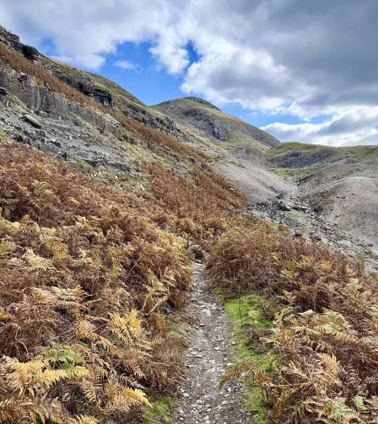
Although not part of the official Fremington Edge walk, I decide to make a brief detour to the disused Fremington Edge Chert Quarries. A tall cairn, shaped like an obelisk, sits on the hillside, offering panoramic views of Reeth and the surrounding countryside.

There is plenty of evidence of the chert quarries around me, with spoil heaps scattered across the landscape. The morning is bright and clear, but I’m conscious of the fact that rain is forecast for 2pm. I should press on, but the views are too good not to pause and enjoy.

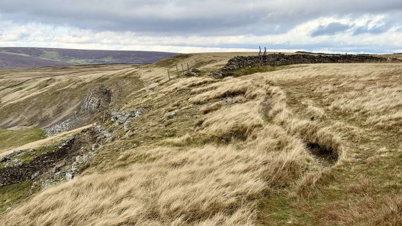
Further up the hill, the stone track splits into two. I take the left-hand track, which then leads to a grassy path. The right-hand track continues uphill to the public footpath across Fremington Edge Top. However, the public footpath runs too far from the edge and behind a high dry stone wall, which blocks the best views.
ADVERTISEMENT
After taking the left fork, I veer left again to follow the grassy path uphill. I believe this is a better option than the official footpath behind the wall. This route keeps me closer to the edge of Fremington Edge, allowing me to enjoy much better vistas.

Walking along Fremington Edge, I’m treated to some incredible views down into the Arkengarthdale valley. From this elevated position just above the steep slopes, I can see Arkle Beck winding its way through the valley. In places where the beck is hidden, the tree line still reveals its course.

The grassy path along Fremington Edge is a real delight. It’s easy to walk and offers exceptional views. The only downside might be in poor weather when the exposed position makes it windy. In that case, the sheltered public footpath behind the dry stone wall might be a better option. But for now, the weather is fine, and this path is the best choice to experience the beauty of Fremington Edge.
ADVERTISEMENT
Although the grassy path isn’t marked as a public footpath on the Ordnance Survey map, it is access land, so walkers have the right to roam. The path crosses several field boundaries, but there are stiles or gaps in the walls, making for easy passage.

The views from Fremington Edge continue to impress. Arkle Beck winds its way through the Arkengarthdale valley, with Calver Hill forming a striking backdrop. Although the day is mostly cloudy, occasional bursts of sunlight break through, illuminating parts of the landscape and creating a stunning scene.

I eventually reach the large, cone-shaped cairn at Fell End, which marks the end of Fremington Edge.

ADVERTISEMENT
This large cairn sits at the north-west end of Fremington Edge and serves as a superb viewpoint.

From the cairn, the views are breathtaking. I can see Arkle Beck flowing through the valley below, with Calver Hill dominating the landscape. The villages of Booze and Langthwaite are visible, adding charm to the already captivating view. The contrasting landscapes—patches of green fields, open moorland, and spoil heaps from disused lead mines—all add to the unique beauty of this area.

Leaving the cairn, I follow the bridleway downhill. The path is well-marked with wooden posts and small piles of stones, making it easy to follow.

As I descend along the zigzagging bridleway, I pass through areas littered with spoil heaps, reminders of the lead mining that once thrived here. Looking up, I can still see the large cairn at Fell End where I just stood.
ADVERTISEMENT
Continuing along the bridleway, I spot the small hamlet of Booze, perched on the opposite hillside.

The bridleway crosses a field and then takes me down a grassy path enclosed by dry stone walls, eventually leading to Storthwaite Hall. At the farmhouse, I pass through a gate and turn left.
After turning left at Storthwaite Hall, I follow the path past another picturesque farmhouse.
My route now takes me through two large fields down to Arkle Beck. Looking up, I can still see the cairn at Fell End. The colours in the landscape are striking, with shades of green, brown, beige, and grey contrasting against the blue sky.

ADVERTISEMENT
I continue along the elevated bridleway from Heggs House, where I find a perfect spot to sit and enjoy my lunch. Even from this lower vantage point, the views through Arkengarthdale valley are excellent. I’m glad I chose this elevated route rather than the footpath along the valley floor.

The landscape is alive with colour. The bracken is transitioning from bright green to deep golden-brown and rich amber. The fields themselves glow in different hues of green, while the distant Calver Hill is occasionally bathed in golden light beneath a soft blue sky scattered with white clouds.

The bridleway between Heggs House and Castle Farm is a delightful stretch—interesting, scenic, and without any difficult terrain.

When I reach Castle Farm, I can’t help but smile. Castle Farm House sits nestled in the valley in the distance, with a public footpath winding past it. I remember the first time I walked there and how confusing I found the route. I took a wrong turn that day, and even now, I often see other walkers looking puzzled as they try to figure it out. From my elevated position today, it’s much easier to see the right way.

ADVERTISEMENT
I always enjoy this view. The dry stone walls lead from Castle Farm to Castle Farm House, with Calver Hill providing a lovely backdrop.

As I follow the track back towards the tarmac lane above High Fremington, I’m treated to another wonderful view of Reeth.

I’m nearing the end of my Fremington Edge walk as I follow the path across a field, down to Reeth Bridge, and finally back into the village.

ADVERTISEMENT