Visit Historic Swaledale Mining Sites on the Gunnerside Gill Walk in Yorkshire
Start your Gunnerside Gill walk in the village of Gunnerside, located in Swaledale in the Yorkshire Dales. There is parking available in the village centre, with space for approximately 15 cars, and public toilets are conveniently located near the King’s Head pub. Once you’ve parked, cross the road bridge towards the pub, then turn immediately left. Follow the signposted path to Gunnerside Gill, keeping Gunnerside Beck on your left for the first half of the walk.
A few minutes into the trail, you’ll see a set of steps on your right, marked as a public footpath. Ascend these steps, and you’ll find yourself in open countryside. Continue along the well-defined path, which closely follows the beck and gently ascends through the valley. The path occasionally rises along the valley’s edge before returning closer to the water, offering a varied and scenic start to your Gunnerside Gill walk.

After around half a mile, you’ll reach the shaded area of Birkbeck Wood. Here, the trail winds through the woodland, gradually gaining elevation as you hike through this peaceful setting. Soon after, you’ll exit the woods and enter a broad area of open pastureland known as Winterings. Continue along the path, following the beck upstream until you reach the old Sir Francis Dressing Floor, a disused lead mining site. Follow the path as it rises north through the valley.
Around a mile further along, you’ll come to another historic mining site, the Bunting Mine and Dressing Floor. Walk through the remnants of this site, then look for the signposted footpath that climbs uphill towards Blakethwaite Dams. The path continues along the side of the valley, offering impressive views of the valley floor below. After about a third of a mile, you’ll spot a small pile of stones marking your next waypoint. Turn left here and descend steeply into the valley to reach the Blakethwaite Smelt Mill.
Once at the mill, cross the footbridge and turn left, making a U-turn to follow a grassy footpath. This path rises gently, heading south along the opposite side of the valley. The trail soon passes Botcher Gill Gate, where it levels out and becomes a wider stone track. Continue south-east along this track below Silver Hill and Jingle Pot Edge.

As the path turns south-west, it gradually descends towards a minor tarmac road. Here, you have the option to shorten your Gunnerside Gill walk by turning left and following the road back to Gunnerside. If you choose to continue, turn right instead and follow the quiet road as it eventually bends left, crossing a bridge over Shore Gill. Continue along this road, which leads into the hamlet of Ivelet.
In Ivelet, turn left immediately after the red telephone box. Follow the lane past the Gunnerside Estate Office, then take the public footpath on your right, marked as the Coast to Coast Low Level Route. This path descends into a small valley, where you’ll cross a footbridge over Shore Gill before ascending to emerge into open meadowland.
From here, continue east across at least a dozen grassy fields for nearly a mile. This path provides splendid views of the surrounding countryside and occasional views of the River Swale. Eventually, you’ll return to Gunnerside, completing your Gunnerside Gill walk in the picturesque Swaledale region of the Yorkshire Dales National Park.
Gunnerside Gill Walk: Maps and Tools
Visit either the OS Maps website or the Outdooractive website to view this walking route in greater detail. Both platforms offer a range of features, including the ability to print the route, download it to your device, and export the route as a GPX file. You can also watch a 3D fly-over and share the route on social media. Additionally, this page includes a printable version of the walk in PDF format. Plus there is a supporting video, available for you to watch on YouTube.
Gunnerside Gill Walk: Distance, Duration, Statistics
Distance: 7 miles
Distance: 11¼ kilometres
Duration: 3½ hours
Ascent: 1163 feet
Ascent: 354 metres
Type: Circular walk


Walking in the Yorkshire Dales with 43 Circular Routes
AD This Cicerone guidebook includes 43 circular walks exploring valleys, hills, and moors between Kirkby Stephen and Pateley Bridge. With OS maps, local highlights, and routes ranging from 3–11 miles, it is a year-round companion for walkers of all abilities.
Recommended Ordnance Survey Map
The best map to use on this walk is the Ordnance Survey map of the Yorkshire Dales Northern & Central Area, reference OS Explorer OL30, scale 1:25,000. It clearly displays footpaths, rights of way, open access land and vegetation on the ground, making it ideal for walking, running and hiking. The map can be purchased from Amazon in either a standard, paper version or a weatherproof, laminated version, as shown below.
Standard Version
About Gunnerside Gill
Gunnerside Gill (also known as Ghyll) is a picturesque valley in the Yorkshire Dales, branching off from Swaledale to the north of the village of Gunnerside. Once a centre for lead mining in the 18th and 19th centuries, the valley still displays abundant evidence of its industrial past. Throughout the valley, streams were dammed, and miners released torrents of water to wash away surface soil and expose lead ore (galena) seams. These dramatic scars, known as hushes, may even echo the sound of the water itself. You’ll find Bunton, Friarfold, and Gorton hushes along the valley’s east side, with North Hush lying on the opposite slope.
As you venture further into the valley, you’ll see large spoil heaps left by mining operations, covering vast sections of the upper valley. Scattered throughout, several historic buildings and mining structures stand as scheduled ancient monuments, marking this area’s unique industrial heritage. On this Gunnerside Gill walk, you’ll pass many of these historic sites, offering a fascinating glimpse into the valley’s mining legacy.
One notable site, the Sir Francis Level, opened in 1864 to access deeper seams. It was the first mine in the area to use compressed air drills, a significant technological advance at the time. However, despite these innovations, the mine was abandoned in 1882 after failing to yield profitable returns.
For those interested in natural history, waterfalls in Botcher Gill, a tributary of Gunnerside Beck, are rich in fossils, adding another layer of interest to the valley’s unique features.
In addition to its mining history, Gunnerside Gill attracts walkers from Alfred Wainwright’s famous Coast to Coast Walk, which traverses the valley’s upper reaches. Created in 1973 by Wainwright, this long-distance trail stretches from St Bees on the Cumbrian coast to Robin Hood’s Bay on the North Sea, crossing three national parks along the way. For many, this section through Gunnerside Gill offers a unique blend of Yorkshire’s natural beauty and historic mining landmarks.
As the valley winds southward, the scenery transforms from rugged industrial remnants to a softer landscape of woodland and sheep pastures. Eventually, Gunnerside Beck flows into the River Swale, completing its journey in the charming village of Gunnerside.
Gunnerside Gill Walk: My Photos
This is Gunnerside Beck, just under half a mile (0.8 kilometres) north of Gunnerside. At roughly this point, a path branches off to the right, climbing the valley side. This path, however, is sometimes overgrown, so it’s often better to stick to the second path that stays close to the beck.


Grisport Unisex Adult Peaklander Hiking Boots
AD The Grisport Unisex Adult Peaklander Hiking Boots are crafted in Italy with a durable waxed leather upper, Spotex breathable lining, and a reliable Track-on rubber sole. Waterproof and weighing just 1120g, they offer comfort, resilience, and dependable performance on demanding trails.
I continue along the narrow path beside Gunnerside Beck. The beck cuts through the steep-sided valley known as Gunnerside Gill, flowing southward towards the River Swale.

As I follow the path through the valley, it gently rises, with the beck below on my left. This path is full of character, and I’m already thoroughly enjoying my Gunnerside Gill walk.

Grisport Unisex Adult Peaklander Hiking Boots
AD The Grisport Unisex Adult Peaklander Hiking Boots are crafted in Italy with a durable waxed leather upper, Spotex breathable lining, and a reliable Track-on rubber sole. Waterproof and weighing just 1120g, they offer comfort, resilience, and dependable performance on demanding trails.
After about a third of a mile (0.5 kilometres) climbing up the valley, the path leads me through Birkbeck Wood, temporarily taking me away from the beck. I pass a large moss-covered boulder near a tree and know I’ll soon emerge into open countryside on my right.

Looking over a dry-stone wall at the edge of Birkbeck Wood, I get a classic view of the Yorkshire Dales. A stone barn nestles into the hillside, with dry-stone walls marking historic boundaries of fields or grazing land up the slopes. Low Scar, a rocky outcrop, is visible at the hilltop on the left side of this photograph.


Fifty Walks Across the Beautiful North York Moors National Park
AD Discover 50 routes across the North York Moors, from short easy strolls to challenging high-level hikes. With OS maps, route descriptions, and local highlights, it also includes the legendary 40-mile Lyke Wake Walk, described in four accessible stages.
At the northern end of Birkbeck Wood, I pass through a small wooden gate in the dry-stone wall and enter the beautiful pastureland called Winterings. The barn on the field’s edge looks charming in the sunlight, its roof still intact and in good condition.

I continue through this lovely pastureland, deeply enjoying my Gunnerside Gill walk. Ahead, I notice spoil heaps, signalling that I’m approaching an historic lead mining site.

Fifty Walks Across the Beautiful North York Moors National Park
AD Discover 50 routes across the North York Moors, from short easy strolls to challenging high-level hikes. With OS maps, route descriptions, and local highlights, it also includes the legendary 40-mile Lyke Wake Walk, described in four accessible stages.
I arrive at the Sir Francis Dressing Floor. Lead mining in Gunnerside Gill dates back to the 15th century, peaking from the 17th to the late 19th centuries. The Sir Francis Level, a major venture started in 1864 by Sir George Denys, aimed to tap into deep-lying deposits but never became commercially successful. Here, the dressing floor was where lead ore, or galena, was crushed and sorted before smelting. This site features a particularly fine set of bouse teams—stone chambers used to store ore-rich material before it was processed.

I continue further north, still walking by the beck along a beautiful footpath. Shortly, the path will lead me off to the right, climbing the valley side and taking me away from the beck.


Osprey Hikelite Unisex Backpack for Comfortable and Lightweight Hiking
AD The Osprey Hikelite backpack combines lightweight design with practical features, including a breathable mesh back panel, soft webbing straps, and stretch mesh water bottle pockets. With zipped storage and an organiser compartment, it is ideal for day hikes and outdoor use.
As I make my way through the countryside, I notice a derelict two-storey stone building across the beck. Currently, I’m on the east side, while this old building sits on the west bank right by the water.

Crossing the beck is not always possible, but today the water level is low enough for me to cross safely. Although there’s no sign to identify this structure, I believe it’s part of the Sir Francis Level and may have been the engine house of the Sir Francis Level Air Receiver—though I’m not entirely sure.

Osprey Hikelite Unisex Backpack for Comfortable and Lightweight Hiking
AD The Osprey Hikelite backpack combines lightweight design with practical features, including a breathable mesh back panel, soft webbing straps, and stretch mesh water bottle pockets. With zipped storage and an organiser compartment, it is ideal for day hikes and outdoor use.
Close to the two-storey stone building is the Sir Francis Level Air Receiver. When miners began driving the Sir Francis Level into Gunnerside Gill in 1864, they used hand-bored shot holes and black powder. In 1870, however, Sir George Denys introduced compressed air drills, marking the first use of this technology in a Yorkshire mine. A waterwheel-driven compressor and air receiver provided ventilation, removing the need for airshafts and allowing men to work continuously.

Now about one and three-quarter miles (2.8 kilometres) north of Gunnerside, I continue my Gunnerside Gill walk, high up on the valley’s eastern side. Looking left, I see Botcher Gill Nook—a distinctive cut in the landscape that I’ll cross later.


Peak Bagging Wainwrights with Routes to Complete All Fells
AD This comprehensive guide offers 45 circular routes linking all 214 Wainwright fells. With maps, GPX downloads, elevation profiles, and practical advice, it provides efficient yet inspiring ways to complete this classic Lake District challenge at your own pace.
A little further on, I spot the impressive rocky outcrop of Swina Bank Scar up to my right.

Looking west from Swina Bank Scar, I see a large, disused spoil tip and derelict stone buildings. My Ordnance Survey map shows that this is the site of the disused Dolly Lead Level.

Peak Bagging Wainwrights with Routes to Complete All Fells
AD This comprehensive guide offers 45 circular routes linking all 214 Wainwright fells. With maps, GPX downloads, elevation profiles, and practical advice, it provides efficient yet inspiring ways to complete this classic Lake District challenge at your own pace.
This landscape is endlessly fascinating. As I continue north past Swina Bank Scar, I have a wonderful view of Gunnerside Beck in the valley below on my left. Ahead, I sense more mining history awaits.

I reach the Bunting Mine and Dressing Floor, located about two and a quarter miles (3.6 kilometres) north of Gunnerside. The Bunting Level was the main access to the workings on Gunnerside Gill’s east side, with mining activity here dating back to the late 18th century. The dressing floor features well-preserved bouse teams for storing ore before dressing, as well as remains of a water-powered crushing mill and a smithy.


Berghaus Hillmaster II GTX Men's High Rise Hiking Boots
AD The Berghaus Hillmaster II GTX men’s hiking boots feature a waterproof, breathable GORE-TEX membrane, a memory foam tongue and collar for a personalised fit, and a Vibram sole delivering exceptional grip, stability, and shock protection for confident performance on any terrain.
At the Bunting Level, a signpost offers a choice: I could descend into the valley via the public footpath on the left, but I choose to stay at a higher level and follow the sign to Blakethwaite Dams.

Keeping to the higher path gives me a bird’s-eye view of Blakethwaite Smelt Mill before I descend into the valley to explore it.

Berghaus Hillmaster II GTX Men's High Rise Hiking Boots
AD The Berghaus Hillmaster II GTX men’s hiking boots feature a waterproof, breathable GORE-TEX membrane, a memory foam tongue and collar for a personalised fit, and a Vibram sole delivering exceptional grip, stability, and shock protection for confident performance on any terrain.
Where Blind Gill meets Blakethwaite Gill, I reach one of the highlights of my Gunnerside Gill walk. There’s an immense amount of history here.

I arrive at Blakethwaite Smelt Mill. Mining output from the upper Gunnerside Gill mines increased sharply in 1819, prompting the construction of this smelt mill. Operational by 1821, the mill used peat and coal to fuel two ore-hearths, processing ore from the Blakethwaite and Lownathwaite mines. The fumes were drawn up a flue to a now-demolished chimney on the crag above.


Kendal Mint Co Energy Gel with Citrus and Mint Flavour
AD Kendal Mint Co energy gels deliver 27g of fast-absorbing carbohydrates plus electrolytes and B vitamins for improved performance. Vegan, gluten free, and Informed Sport certified, these caffeine-free gels are refreshing, easy to digest, and ideal for running, cycling, and endurance.
At Blakethwaite Smelt Mill, a large stone slab serves as the footbridge over the beck.

From the footbridge, I look north into Blakethwaite Gill. There’s a public bridleway leading further up the valley towards Blakethwaite Dams, but I’ll save that adventure for another day.

Kendal Mint Co Energy Gel with Citrus and Mint Flavour
AD Kendal Mint Co energy gels deliver 27g of fast-absorbing carbohydrates plus electrolytes and B vitamins for improved performance. Vegan, gluten free, and Informed Sport certified, these caffeine-free gels are refreshing, easy to digest, and ideal for running, cycling, and endurance.
After crossing the footbridge, I look back at the derelict mine buildings. There’s so much to see here. I decide to pause and enjoy my lunch before continuing.

Now heading south on the valley’s western side, I pass North Hush, marked on the Ordnance Survey map as part of the disused Lownathwaite Lead Mines.


Thermos Stainless King Flask for Travel and Daily Adventures
AD The Thermos Stainless King 470ml flask keeps drinks hot for 18 hours or cold for 24. With durable stainless steel, vacuum insulation, a serving cup, and a leakproof design, it is perfect for commutes, journeys, and outdoor adventures.
I pass through Botcher Gill Gate, where a waterfall cascades over the hillside. The water has carved a narrow channel known as Botcher Gill Nook. I saw this feature earlier from the eastern valley side.

My route continues south across Silver Hill. Looking east across Gunnerside Gill, I see Winterings Scar, part of Winterings Edge and Melbecks Moor. More disused spoil tips line the hillside, reminders of the lead mining industry.

Thermos Stainless King Flask for Travel and Daily Adventures
AD The Thermos Stainless King 470ml flask keeps drinks hot for 18 hours or cold for 24. With durable stainless steel, vacuum insulation, a serving cup, and a leakproof design, it is perfect for commutes, journeys, and outdoor adventures.
Following the path along Silver Hill’s eastern slopes, I enjoy superb views. Below, Gunnerside Beck meanders through the valley of Gunnerside Gill, flowing towards the River Swale. The hills on Swaledale’s south side, including Blea Barf, Pickerstone Ridge, and High Carl, create a stunning backdrop.

From this vantage point, I can see the barn at Winterings and the Sir Francis Dressing Floor, both of which I passed earlier. The beck sparkles in the sunlight as it winds through the valley.

Lake District High Level and Fell Walks with Thirty Routes
AD This pocket-sized guide presents 30 routes on the Lake District’s highest fells, including Scafell Pike, Helvellyn, and Blencathra. With OS maps, colour photographs, and practical notes, it offers circular walks from 4–15 miles graded by difficulty.
Continuing along the slopes of Jingle Pot Edge, I look east and see the rocky outcrop known as High Scar at the very top of the steep hillside. The landscape is dotted with fields, dry-stone walls, and stone barns, creating a classic patchwork of the Yorkshire Dales.

Rounding Jingle Pot Edge, I’m greeted by stunning views to the east, right across the Swaledale valley floor, with the village of Gunnerside visible below.

Lake District High Level and Fell Walks with Thirty Routes
AD This pocket-sized guide presents 30 routes on the Lake District’s highest fells, including Scafell Pike, Helvellyn, and Blencathra. With OS maps, colour photographs, and practical notes, it offers circular walks from 4–15 miles graded by difficulty.
Continuing my Gunnerside Gill walk, I cross a bridge over Shore Gill and follow the road towards Ivelet.

Upon entering Ivelet, a small hamlet in Swaledale, I turn left just past the red telephone box.

Super Sparrow Stainless Steel Insulated Water Bottle with Two Lids
AD The Super Sparrow stainless steel water bottle keeps drinks cold for 12 hours or hot for several. With a straw lid, bamboo cap, BPA-free construction, and durable 18/8 steel, it is ideal for sport, travel, work, and outdoor use.
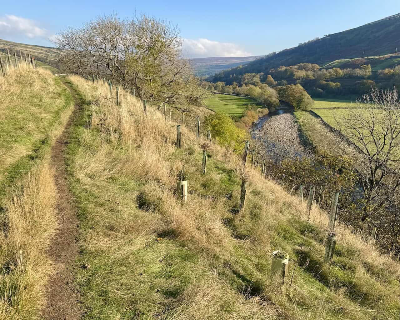
Leaving Ivelet, I have slightly less than a mile (1.6 kilometres) to go. The path heads east across several fields, passing through gates in dry-stone walls. This relaxing section is a perfect way to wind down the walk.

Halfway along this final stretch between Ivelet and Gunnerside, I look to my right and see the River Swale below.
Super Sparrow Stainless Steel Insulated Water Bottle with Two Lids
AD The Super Sparrow stainless steel water bottle keeps drinks cold for 12 hours or hot for several. With a straw lid, bamboo cap, BPA-free construction, and durable 18/8 steel, it is ideal for sport, travel, work, and outdoor use.
I’m nearly back in Gunnerside, reflecting on what an incredible journey my Gunnerside Gill walk has been. The village lies just ahead, marking the end of a memorable day.
