ADVERTISEMENT
Robin Hood’s Bay Views and Coastal Scenery on the Hayburn Wyke Walk
The Hayburn Wyke walk begins at the small pay-and-display car park close to the Hayburn Wyke Hotel. The car park is designated for visitors to the nature reserve, the waterfall, and the cave, and is clearly signposted as such. At the time of writing, the charge was £5 for the day, payable by cash only.
Leave the car park and head towards the Hayburn Wyke Hotel. Walk past the front of the hotel, following the sign for motorhomes, then continue straight ahead through the large metal gate into the fields beyond. Follow the public footpath across the fields and, shortly after, bear right to head down into the woodland. Go through the gate to enter the woodland, where a sign marks the entrance to the Hayburn Wyke National Trust area.
Descend the steps, turn left, and follow the footpath downhill through the woods. After the steps, pass the first turnings to the left and right without taking them, and continue straight ahead as the path sweeps around to the right. Follow the path through the woods, gradually descending towards the coast. When the path splits near a wooden signpost, take a moment to visit the waterfall on the left before continuing downhill, following the signpost marked for the Cleveland Way to Ravenscar.
ADVERTISEMENT
At the bottom, explore the rocky beach and waterfall if you wish. When you are ready to continue, cross the footbridge over Hayburn Beck and follow the Cleveland Way up the stone steps on the opposite side of the valley. Shortly after, descend slightly and cross a second footbridge. Continue following the Cleveland Way up further steps and out of the valley to reach the clifftop.
Now follow the straightforward clifftop coastal path for just over a mile to reach Petard Point, where a signpost indicates a left turn to Staintondale. Ignore this turning and continue straight ahead on the Cleveland Way. After a further one and a half miles you will reach the site of the Ravenscar World War II Radar Station. Take time to explore this fascinating site before continuing north along the Cleveland Way clifftop path.
After about two thirds of a mile, you will reach a signpost pointing left to Ravenscar Tea Rooms. Continue straight ahead along the Cleveland Way for now, as you will return to the tea rooms later in the walk. Pass the large white late-Victorian house on your left, known as Cliff House and dated 1899. Continue along the grassy clifftop path until you can go no further, then turn left onto Hammond Road, a wide rough track.
Continue straight ahead along Hammond Road to reach Station Road, then turn right into Ravenscar, still following the signs for the Cleveland Way. At the end of Station Road, walk past the driveway entrance to the Raven Hall Hotel and follow the track on your right, downhill, signposted to Peak Fault as a public footpath. Head downhill along the track to enjoy one of the finest views on the Hayburn Wyke walk, looking out across Robin Hood’s Bay.
ADVERTISEMENT
Continue down, keeping to the track as it bends around to the left in a U-turn and doubles back on itself above the golf course. Follow the track down towards the trees, then turn left onto the public footpath just before the cattle grid and follow the path back uphill. You will now be walking on the left-hand side of a dry stone wall. Walk past the farmhouses and wooden sheds, then turn right onto the tarmac lane. At the top, turn left and follow the concrete lane past the Ravenscar Visitor Centre. Continue straight ahead onto Station Road and follow it along to the Ravenscar Tea Rooms.
At the tea rooms, turn right and walk in front of the buildings to reach the platform of the former Ravenscar railway station. Turn left and walk along the platform to join the Cinder Track, heading south in the direction of Scarborough. Continue straight ahead through a set of wooden gates signposted for the Cinder Track. Follow the grey gravel path south for two thirds of a mile and pass through the tunnel beneath Bent Rigg Lane.
Continue on the Cinder Track for a further one and three quarter miles to reach the former station at Staintondale. Pass straight through the station, between the two platforms, and continue through the tunnel a little further along. Follow the Cinder Track for another mile, after which you will notice a track on your left leading back down to the Hayburn Wyke Hotel, completing the Hayburn Wyke walk.
Hayburn Wyke Walk: Maps and Tools
Visit either the OS Maps website or the Outdooractive website to view this walking route in greater detail. Both platforms offer a range of features, including the ability to print the route, download it to your device, and export the route as a GPX file. You can also watch a 3D fly-over and share the route on social media. Additionally, this page includes a printable version of the walk in PDF format. Plus there is a supporting video, available for you to watch on YouTube.
Hayburn Wyke Walk: Distance, Duration, Statistics
Distance: 9¼ miles
Distance: 14¾ kilometres
Duration: 4½ hours
Ascent: 1256 feet
Ascent: 383 metres
Type: Circular walk
ADVERTISEMENT
Recommended Ordnance Survey Map
The best map to use on this walk is the Ordnance Survey map of the North York Moors Eastern Area, reference OS Explorer OL27, scale 1:25,000. It clearly displays footpaths, rights of way, open access land and vegetation on the ground, making it ideal for walking, running and hiking. The map can be purchased from Amazon in either a standard, paper version or a weatherproof, laminated version, as shown below.
North York Moors Walking Guidebooks
North York Moors Pathfinder Walking Guide, by Brian Conduit and Dennis Kelsall, describes 28 circular walks of 3 to 11 miles from the coast at Whitby to the Cleveland Hills, graded by length and difficulty, with OS Explorer map extracts, GPS waypoints and parking information for every route.
100 Walks in Yorkshire: North York Moors and Wolds, by Gary Richardson, offers routes of up to 10 miles to suit all abilities, with easy-to-follow directions, Ordnance Survey route maps, and details of parking and places to eat and drink. Both books can be purchased from Amazon, as shown below.
North York Moors Pathfinder
About Hayburn Wyke
Hayburn Wyke is one of the most distinctive natural spots on this stretch of the Yorkshire Coast. Rather than open clifftop scenery, it has the feel of a sheltered coastal valley, with paths dropping through ancient woodland to a rocky bay where Hayburn Beck reaches the shore in a double waterfall. That combination of trees, beck, rock and sea gives the place its special character, and it’s one of the reasons a Hayburn Wyke walk feels so different from many other walks nearby.
There is also much more to Hayburn Wyke than its scenery. It is a Site of Special Scientific Interest, recognised for both its geology and its wildlife. The cliffs here date from the Middle Jurassic period and are capped by a thick layer of boulder clay. As Hayburn Beck has cut its way through the valley, it has exposed the Hayburn Wyke plant bed, part of the Cloughton Formation. This exposure contains around sixty fossil species, especially cycads, and it has long been regarded as one of Yorkshire’s most important Jurassic plant fossil sites. One liverwort species found here is known only from Hayburn Wyke, which makes the site especially significant.
Related Walk: Similar to the Hayburn Wyke Walk
Alum Works and Boggle Hole on the Ravenscar walk to Robin Hood’s Bay
The woodland is just as important as the geology. The slopes above the shore are covered with deciduous woodland that follows the line of the beck and gradually merges into mixed woodland further inland. Trees here include oak, ash, birch, elm and large-leaved lime, with hazel, holly and willow growing beneath them. The damp, sheltered conditions also support a rich variety of ferns, mosses and liverworts, adding to the lush, hidden feel of the valley.
Hayburn Wyke is also rich in birdlife. Breeding birds recorded here include chiffchaff, willow warbler, pied flycatcher, redstart and blackcap, which helps make the woodland feel lively in spring and summer. What makes the place so memorable is the way all these elements come together in one relatively small valley. On a Hayburn Wyke walk, you’re not simply visiting a pretty cove with a waterfall. You’re exploring a landscape where ancient woodland, active natural processes and nationally important fossil beds all meet in one remarkably beautiful place.
Hayburn Wyke Walk: My Photos
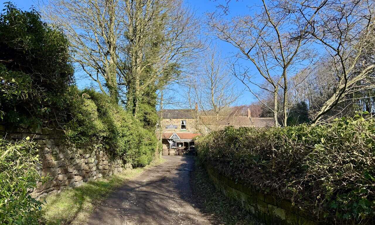
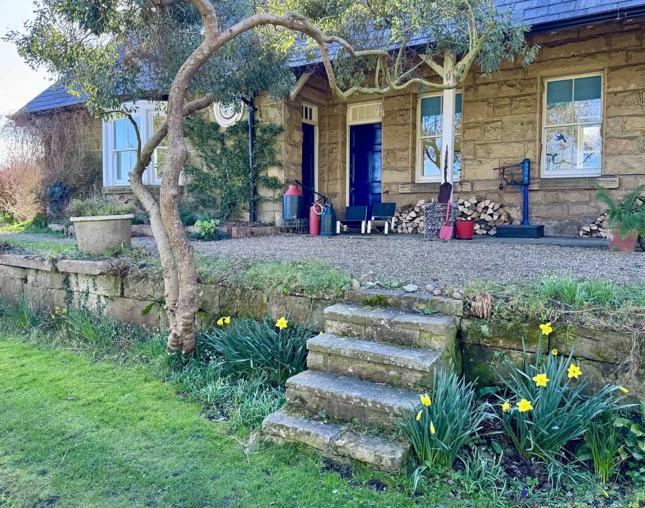
I set off from the small pay-and-display car park near the Hayburn Wyke Hotel on a gloriously clear morning. The short lane leading towards the hotel is sheltered, flanked by old stone walls and trees reaching up into a brilliant blue sky. It’s a promising start to the Hayburn Wyke walk.
ADVERTISEMENT
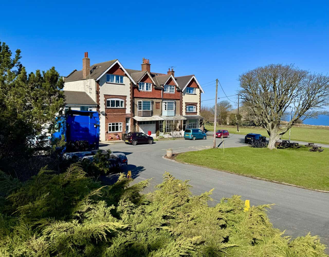
The Hayburn Wyke Hotel is a charming stone-built pub sitting at the heart of this peaceful corner of the North Yorkshire coast. An 18th-century coaching inn with outdoor benches and wooden barrels arranged out front, it has the feel of a classic country pub. It’s a welcoming sight at the start of the walk, and well worth bearing in mind for the return.

From the hotel, I cross a field and drop down into the woodland, where a National Trust sign marks the entrance to Hayburn Wyke. The trees close in around me and the path winds ahead through the dappled light. It’s a beautiful introduction to this stretch of the walk.

ADVERTISEMENT
Before heading down to the coast, I take a short detour to visit the waterfall formed by Hayburn Beck as it tumbles over a series of mossy rocks through the woodland. The beck cascades in several small drops, the water catching the light as it rushes between banks of moss-covered stone. It’s a lovely spot, and well worth the brief diversion.
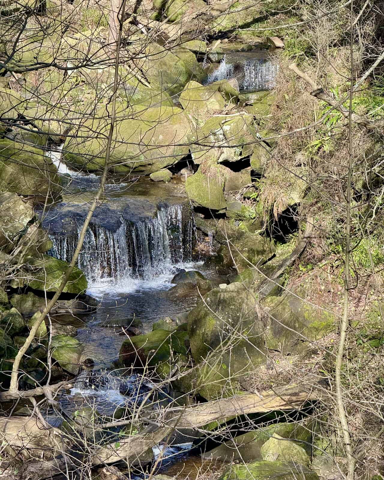
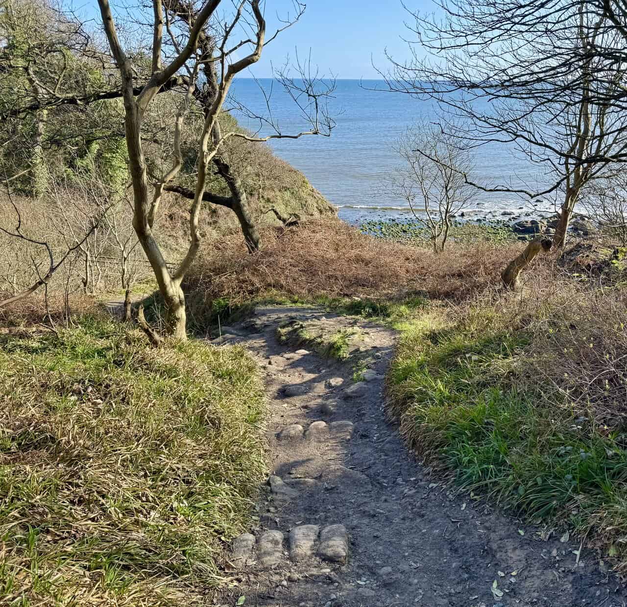
Returning from the waterfall, I continue down through the trees and the sea begins to appear through the branches ahead. The path descends gradually, its surface worn and rocky underfoot, until the full sweep of Hayburn Wyke opens up before me. It’s a wonderful first glimpse of the coast.
ADVERTISEMENT
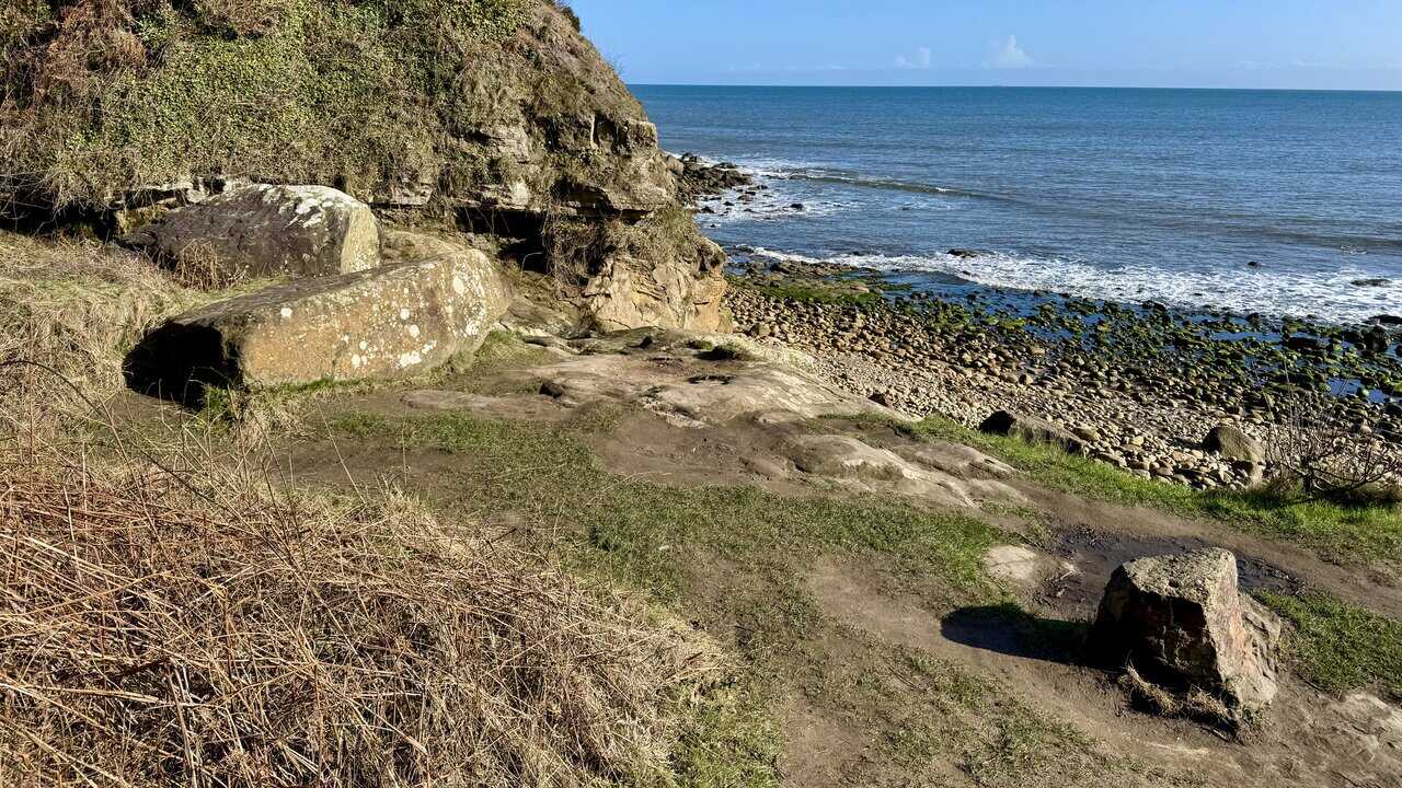
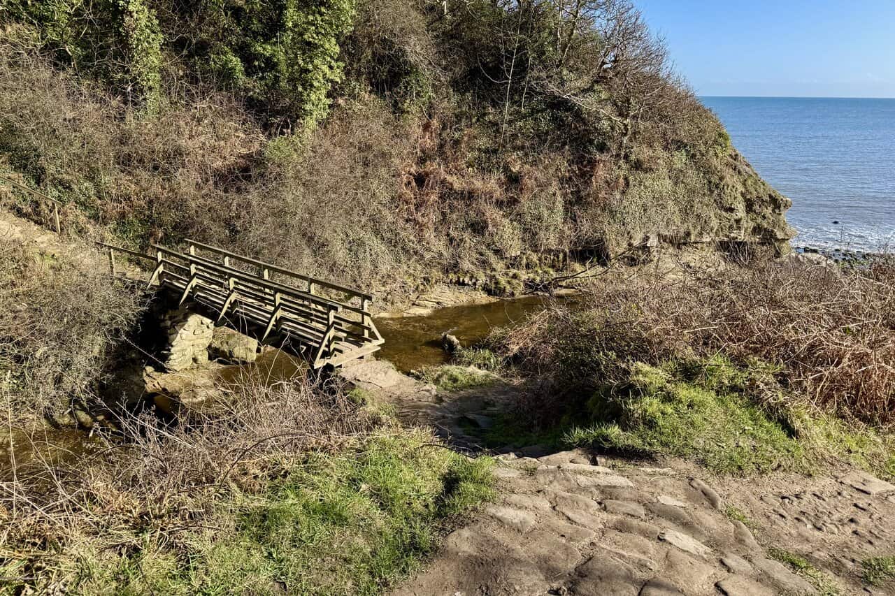
At the bottom of the path, a wooden footbridge crosses Hayburn Beck just before it reaches the sea. I’ll be using that a little later, crossing over and heading up through the valley to continue the walk. But first, it’s time to explore the beach at Hayburn Wyke.
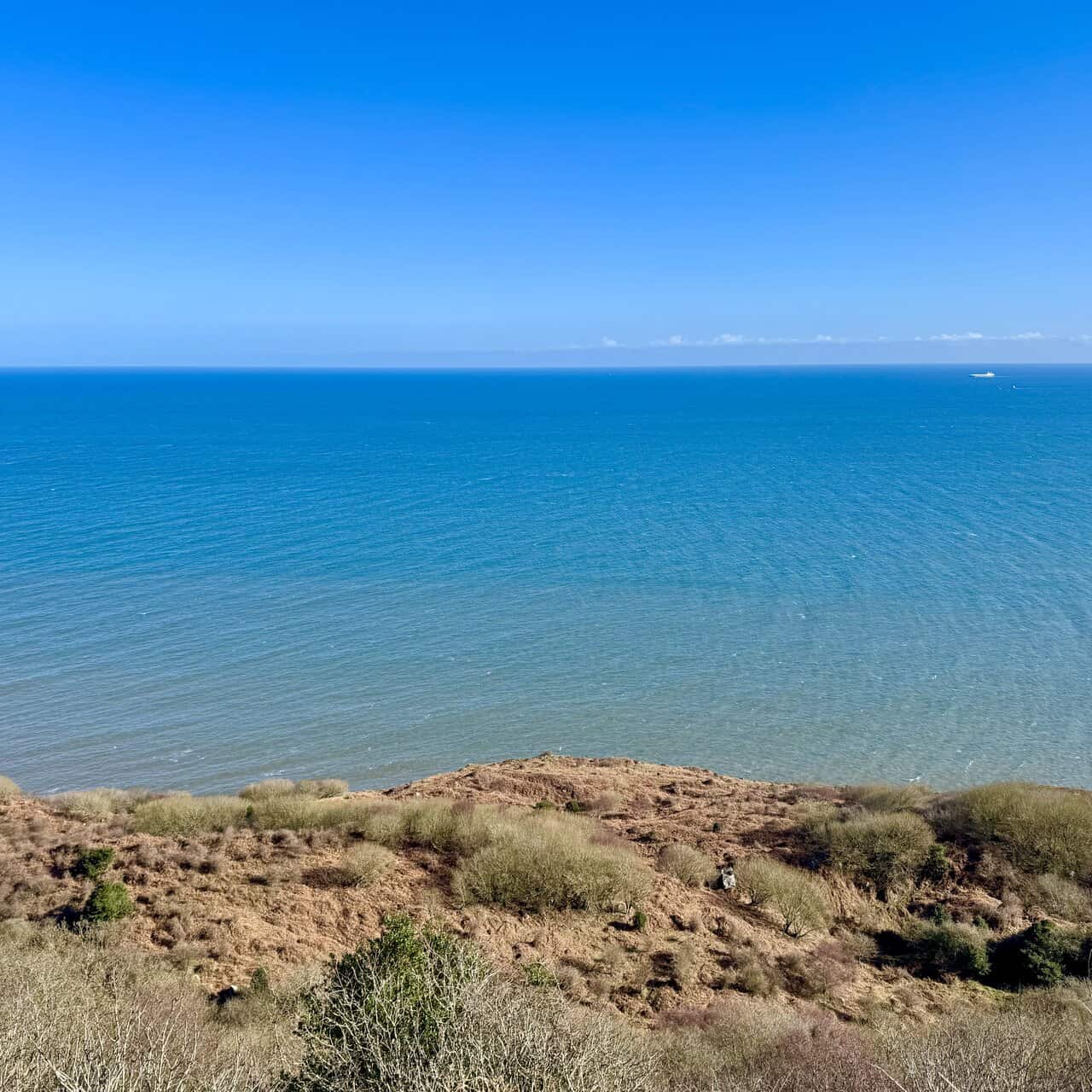
A short path leads to a flat rocky ledge with a fine view over the beach and out across the North Sea. It’s the perfect spot to stop for an early coffee and take in the surroundings. Hayburn Wyke is a wonderfully unspoilt little cove, with its rocky shore, tumbling cliffs, and the sound of the waves below.
ADVERTISEMENT
Down on the beach, Hayburn Beck makes its final journey over the rocks and tumbles onto the shore as a small but charming waterfall. It’s a delightful feature, with the beck cascading over the cliff face into a pool surrounded by boulders and rounded pebbles. Few beaches can boast their own waterfall, which makes Hayburn Wyke a particularly special place.
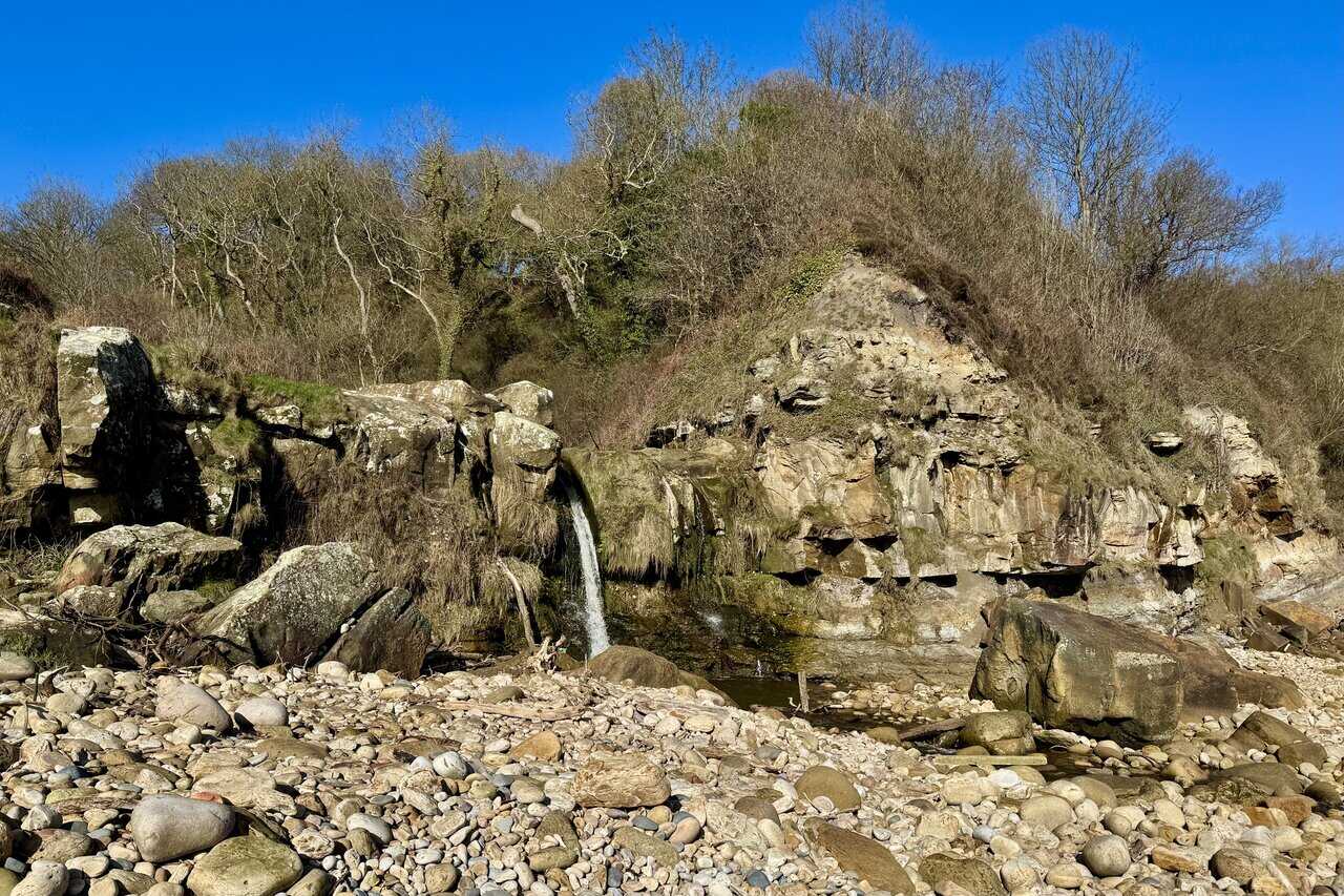
Looking north along the beach, the cove stretches out in a sweep of rounded boulders and pebbles, their surfaces worn smooth by centuries of wave action. Seaweed-covered rocks emerge from the water’s edge, vivid green against the pale stone. It’s a wild and beautiful shoreline, completely unspoilt and utterly peaceful.

ADVERTISEMENT
Moving closer to the waterfall, I get a better sense of just how special this spot is. Hayburn Beck tumbles over the low cliffs and falls directly onto the beach below, a remarkably rare natural feature. The beck has also, over time, exposed the Hayburn Wyke plant bed in the cliff face, which contains fossils of around sixty species dating back to the Middle Jurassic period, making this a place of considerable geological interest as well as natural beauty.

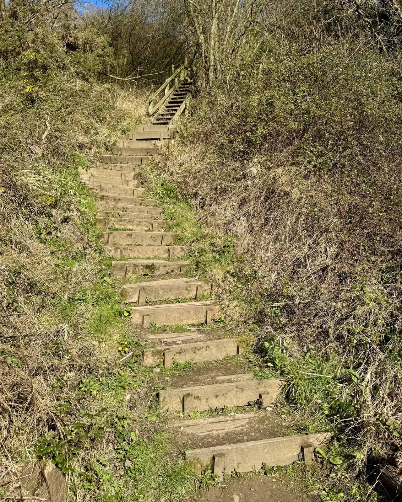
Returning to the footbridge, I cross Hayburn Beck and begin the climb up the other side of the valley on a long flight of wooden steps. They are steep and worth taking at a steady pace, and like much of the path infrastructure in this area, they are maintained by dedicated volunteers. It’s one of the more memorable moments of the Hayburn Wyke walk, leaving the sheltered cove behind and heading back up towards the coastal path above.
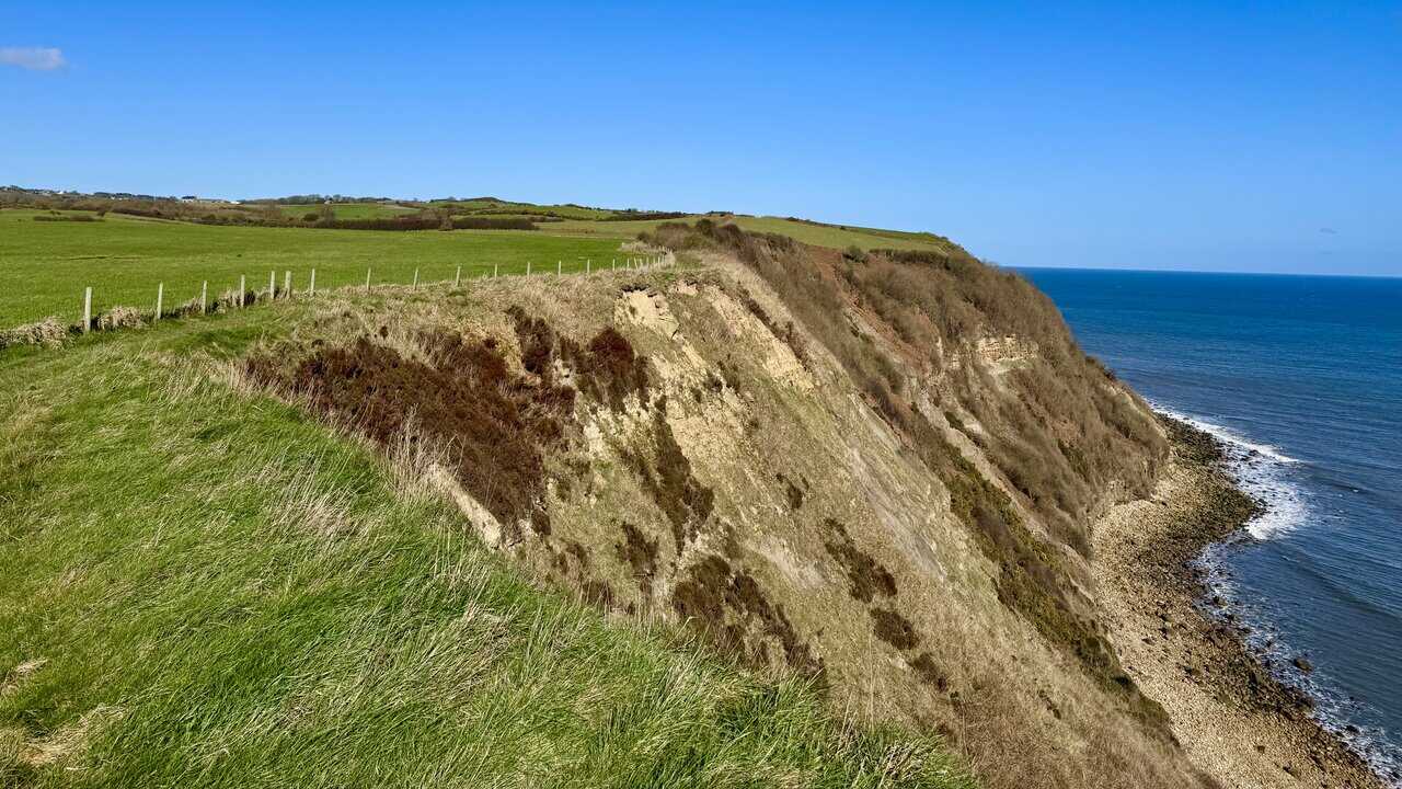
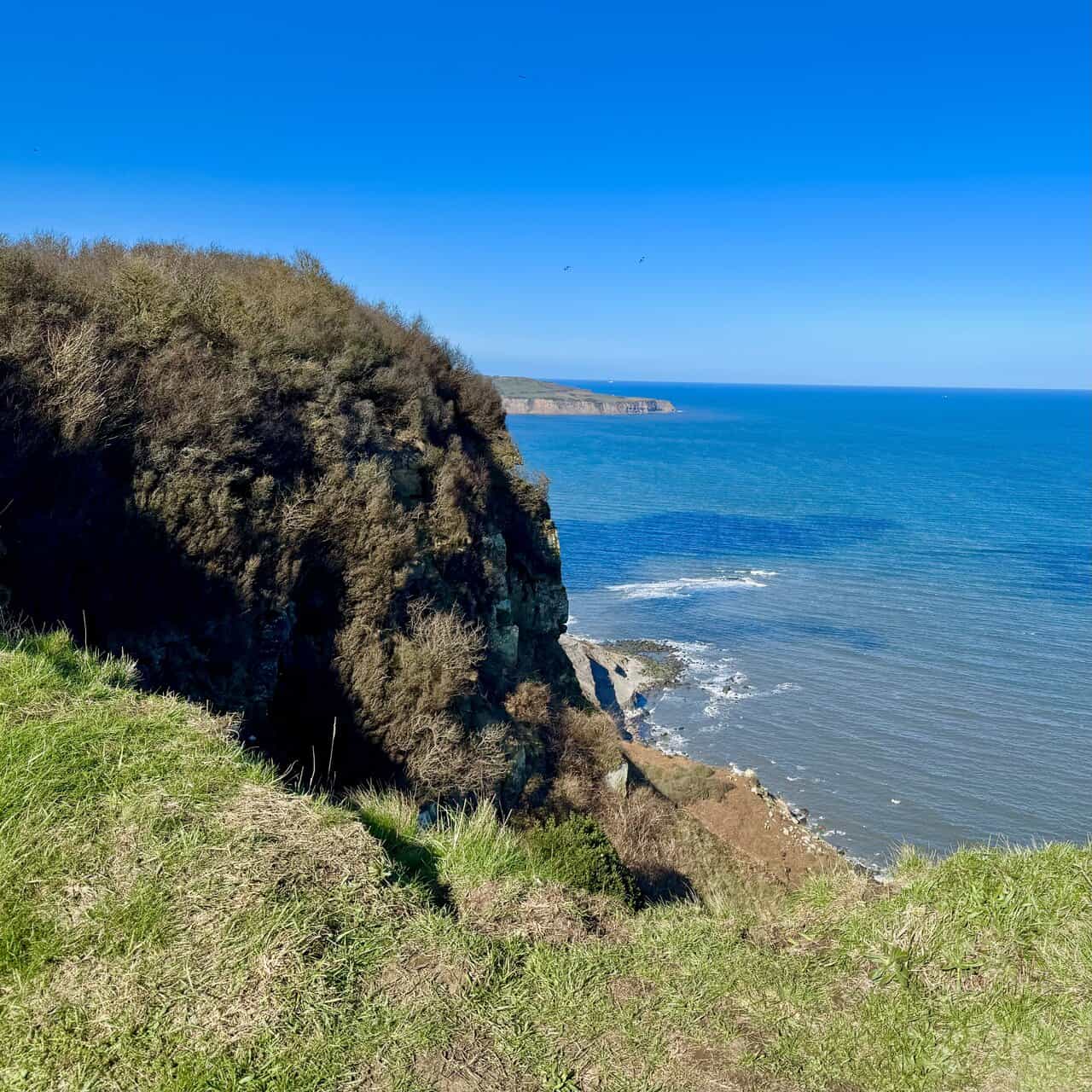
Back on the clifftop, the path heads north and the views open up dramatically. To the right, the cliffs drop sharply to the rocky shore below, their eroding faces revealing the layered geology of this ancient coastline. To the left, green fields stretch away inland under a wide, clear sky.
ADVERTISEMENT
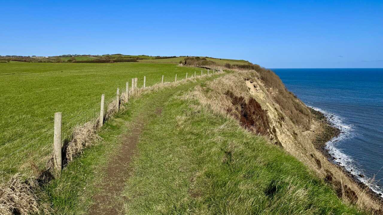
The clifftop path heads north, wide and clear underfoot, with the green fields of North Yorkshire stretching away to the left and the North Sea to the right. This is the Cleveland Way National Trail, one of England’s most celebrated long-distance walking routes. Opened in May 1969, it was only the second National Trail to be officially recognised in England and Wales, covering 109 miles between the market town of Helmsley and Filey Brigg on the coast.
The path dips and rises as it follows the clifftop contours, winding through patches of gorse and scrub before opening up again to reveal sweeping views along the coast. The Cleveland Way follows a horseshoe-shaped course, crossing the heather moorland of the North York Moors before turning south along the coast, taking in fishing villages, ruined abbeys, and dramatic cliff scenery along the way. Up to 2,000 walkers complete the full route every year, while many more enjoy shorter sections such as this one.
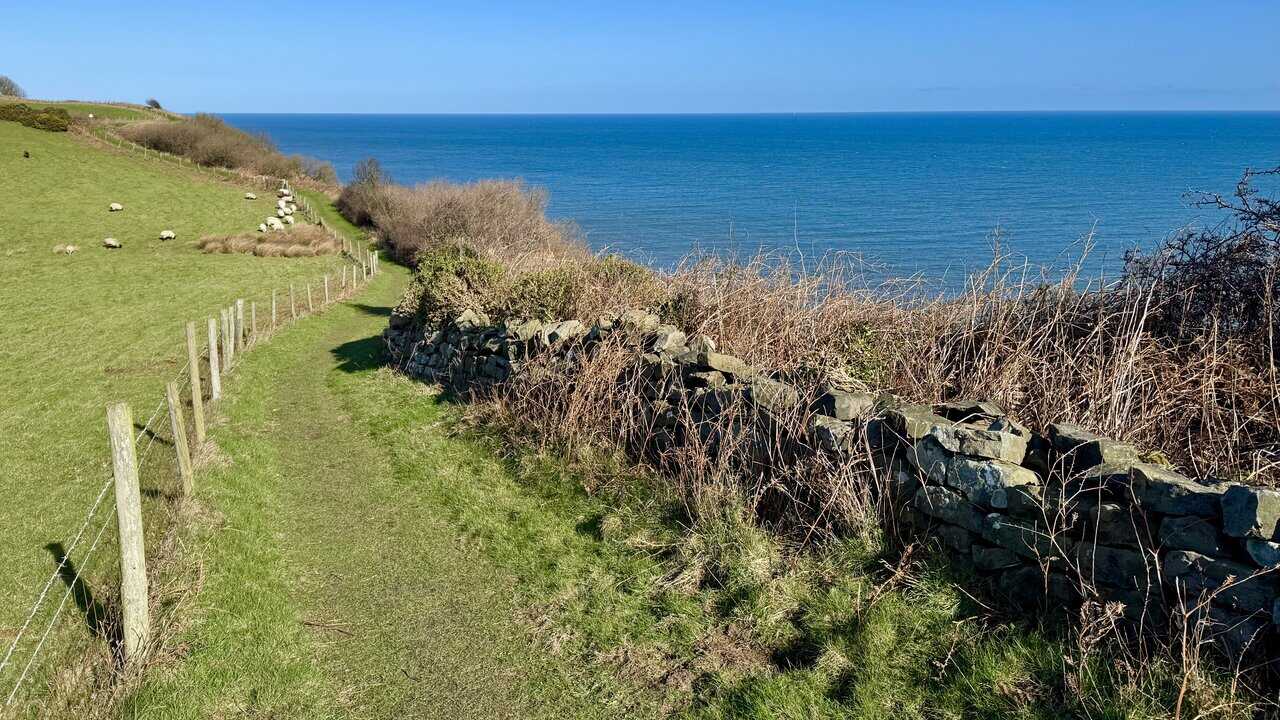
A dry stone wall runs along the cliff edge, with sheep grazing peacefully in the fields beyond and the wide expanse of the North Sea filling the horizon ahead. This stretch of the Cleveland Way also forms part of the King Charles III England Coast Path, an ambitious new National Trail that is currently nearing completion and, at around 2,700 miles, will be the longest managed coastal walking route in the world. It will encircle the entire English coastline, linking world-famous landmarks with hidden corners that many walkers have never previously been able to access.
ADVERTISEMENT
Looking north along the clifftop, the coastline stretches dramatically ahead, the cliffs dropping sharply to the rocky shore below, their layered faces showing clear signs of ongoing erosion. On this section, the Cleveland Way and the King Charles III England Coast Path share the same route, with the Cleveland Way waymarked on the ground and the England Coast Path shown on the Ordnance Survey map. It’s a magnificent stretch of walking, with the kind of wide-open coastal scenery that makes the North Yorkshire coast one of the finest walking destinations in England.

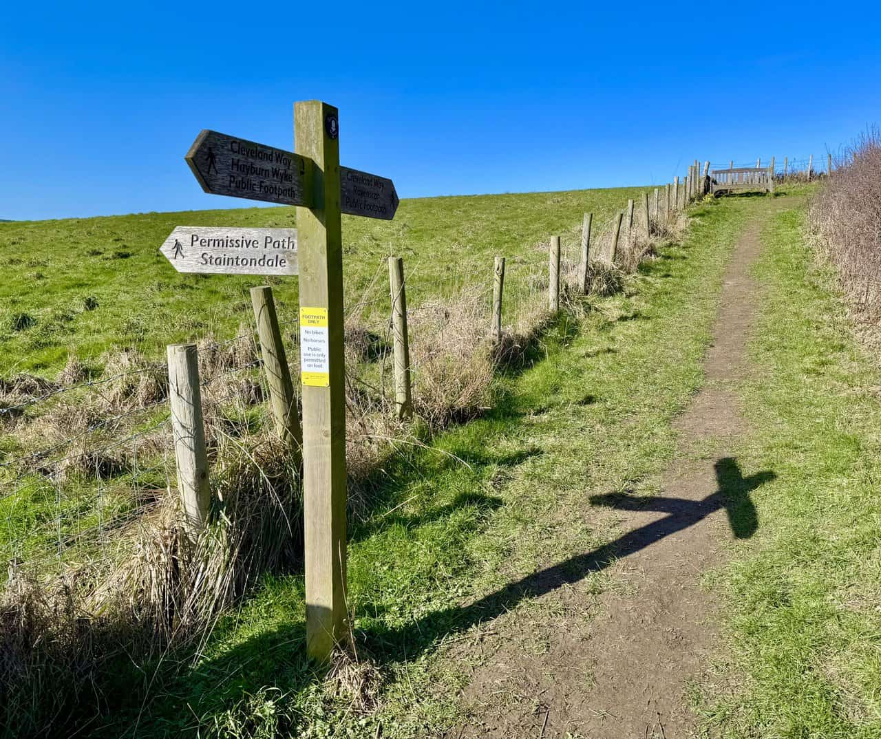
After around one and a quarter miles of clifftop walking, I reach Petard Point, where a wooden signpost marks the junction with the permissive path to Staintondale. I keep straight ahead on the Cleveland Way, and just beyond the signpost I find a welcome bench with a fine view out over the North Sea. It’s a perfect spot to take a short break and enjoy a coffee before continuing north along the path.
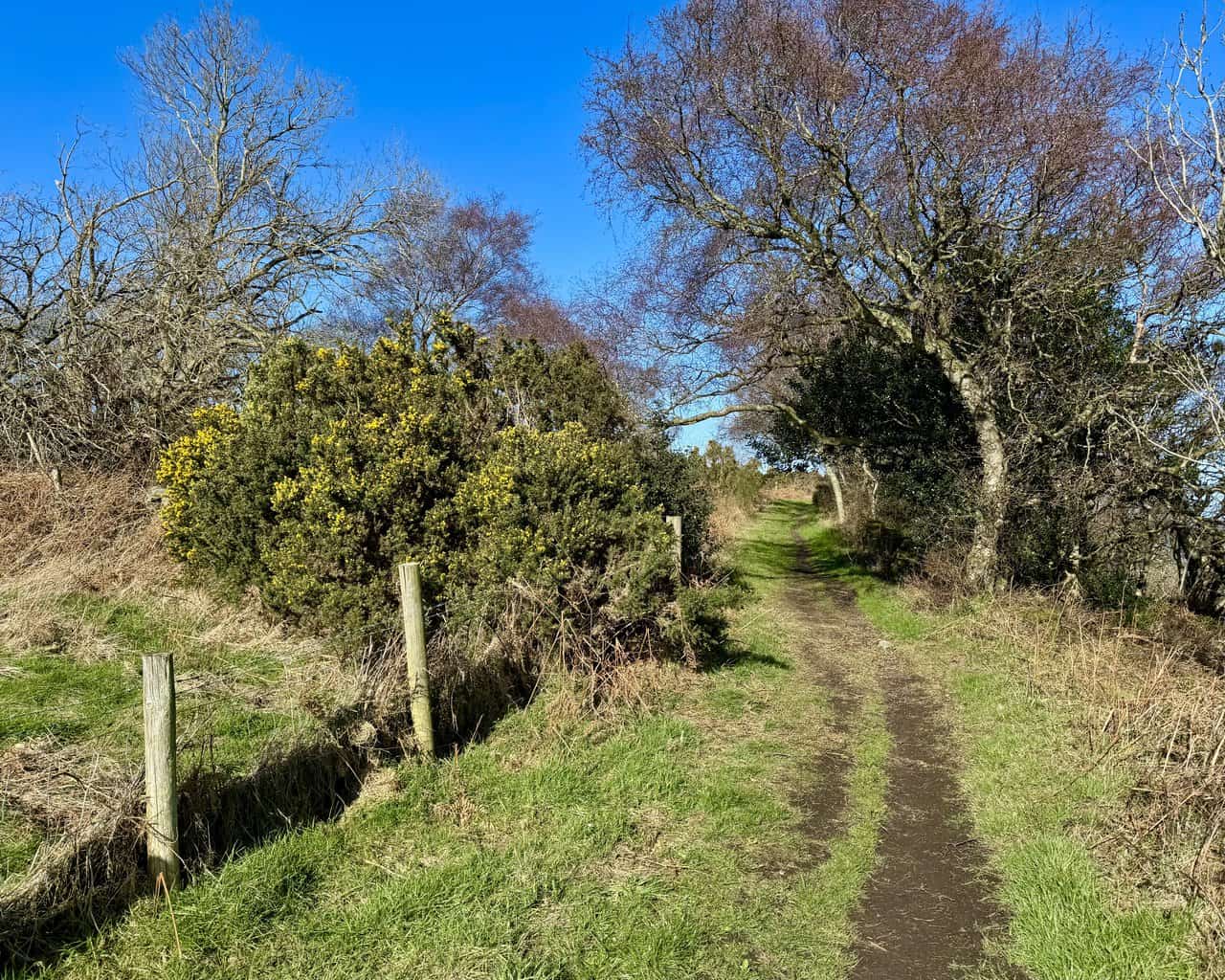
Continuing north, the path narrows and becomes more sheltered, with gorse bushes pressing in on either side and trees arching overhead. It’s a pleasant change of character after the open clifftop, and the path feels almost tunnel-like as it winds through the scrub. The contrast between this enclosed section and the wide coastal views on either side makes the walk all the more varied and enjoyable.
ADVERTISEMENT
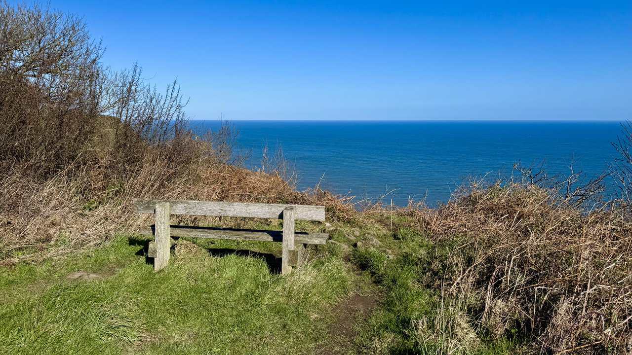
The path soon opens out again to reveal a simple wooden bench perched right on the cliff edge, looking out over a vast, calm expanse of the North Sea. It’s a wonderfully placed seat, tucked among the scrub with an uninterrupted view stretching all the way to the horizon. Few benches can claim a finer outlook than this one.
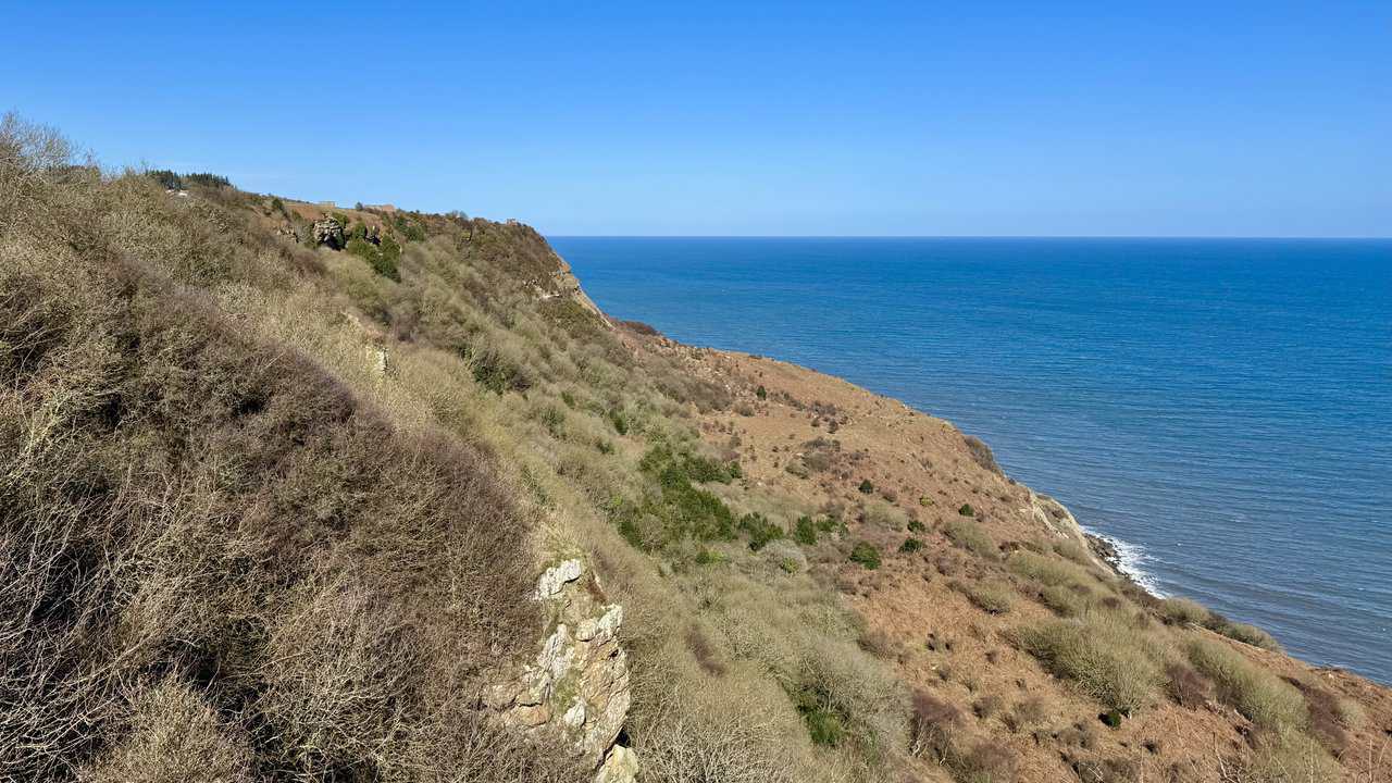
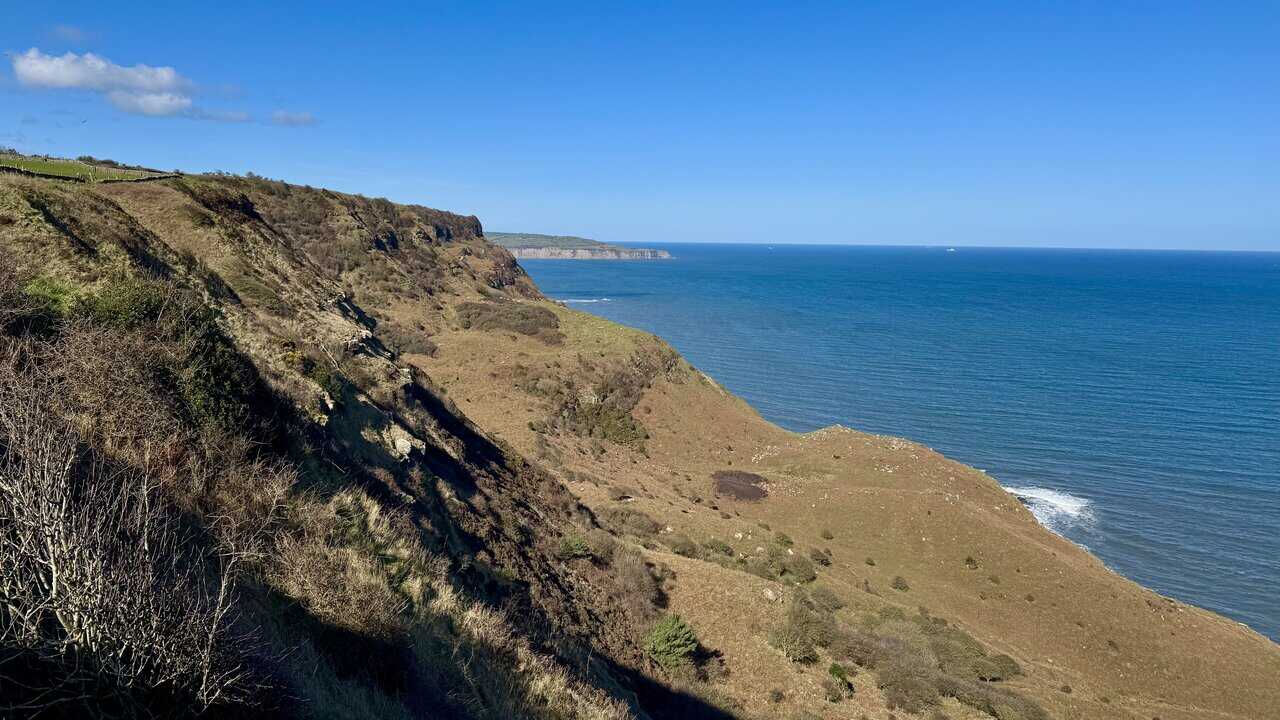
The path brings me to the clifftop above Common Cliff, where the coastline curves dramatically away to the north, the cliff face falling steeply through scrub and bare rock to the sea below. The views along this stretch are among the finest on the Hayburn Wyke walk, with the rugged North Yorkshire coastline stretching away into the distance under a vast blue sky.
Looking out to sea, the North Sea stretches away to the horizon in a deep, vivid blue, calm and seemingly endless. A solitary cargo ship sits far out on the water, the only sign of life on an otherwise empty horizon. It’s a scene of real tranquillity, and one of those moments on a clifftop walk where it’s hard not to simply stop and stare.
ADVERTISEMENT
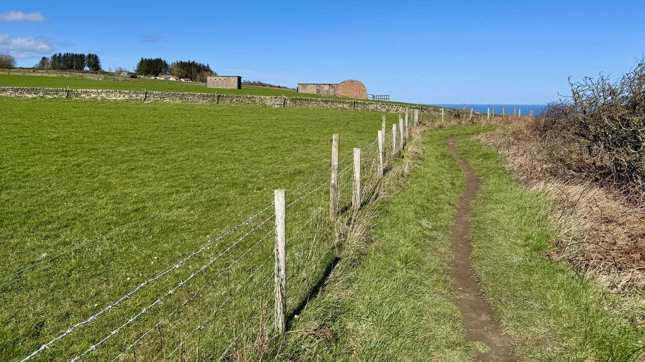
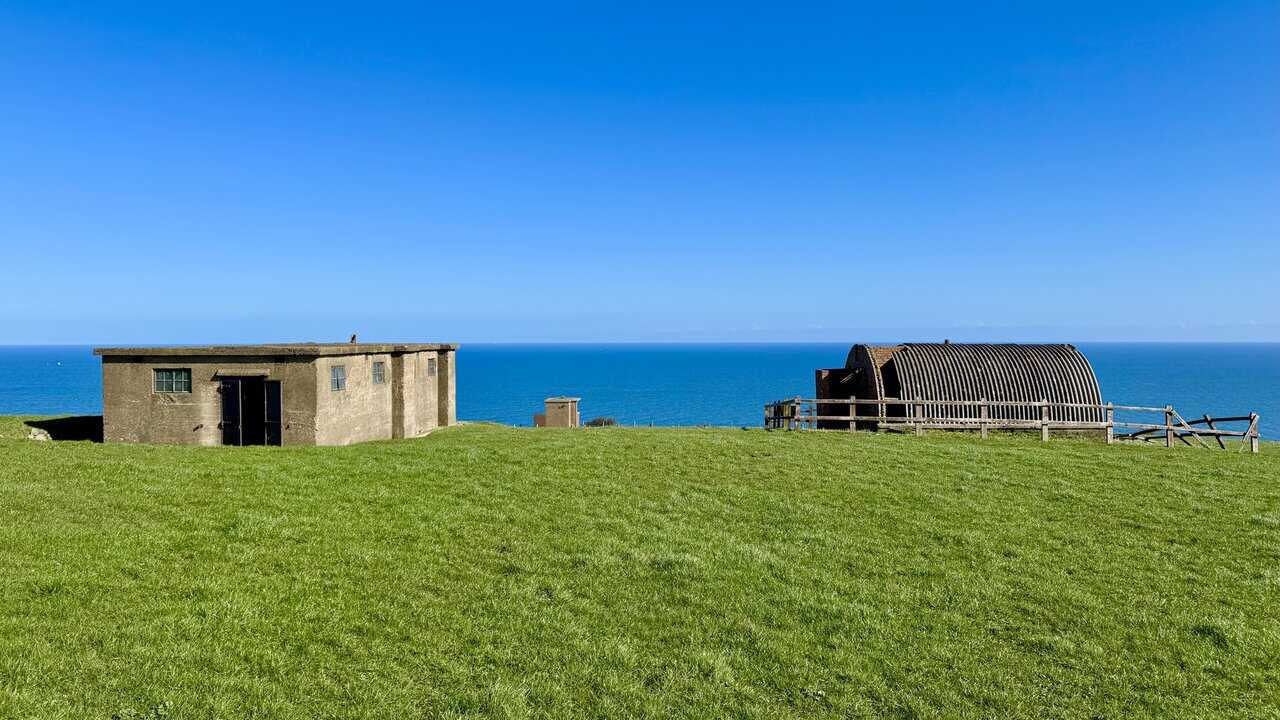
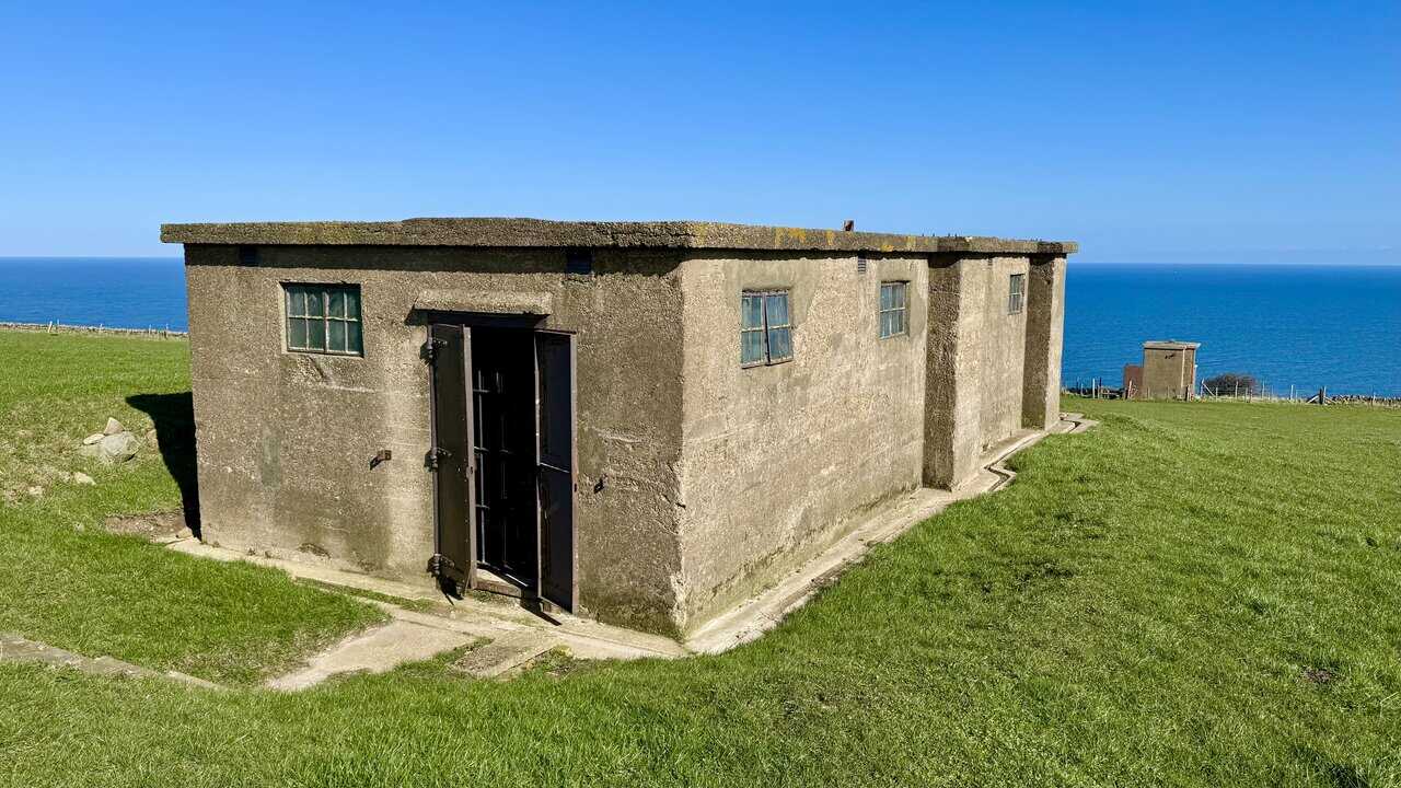
Continuing north along the clifftop, the path runs between green fields and the cliff edge, with a fence bordering the farmland to the left and the North Sea stretching out to the right. As the path curves ahead, a collection of brick and stone structures gradually comes into view in the distance, sitting incongruously on this otherwise open and unspoilt stretch of coastline. These are the surviving remains of the Ravenscar World War II Radar Station, and they tell a compelling story of a nation on high alert.
During the Second World War, Britain faced the very real threat of a German invasion, and this station formed part of a chain of coastal radar installations built in 1941 and 1942 specifically to detect an approaching enemy fleet. Opened in early 1942, the station worked by sending short pulse radio signals out across the sea. When those signals struck an object, they bounced back, and the time taken to return revealed precisely how far away the object was. That information was then passed by telephone landline to the Naval Plotting Room at Immingham in Lincolnshire, where it was cross-referenced against records of known friendly shipping movements. Anything unidentified was considered potentially hostile and could have been the first warning of an invasion force.
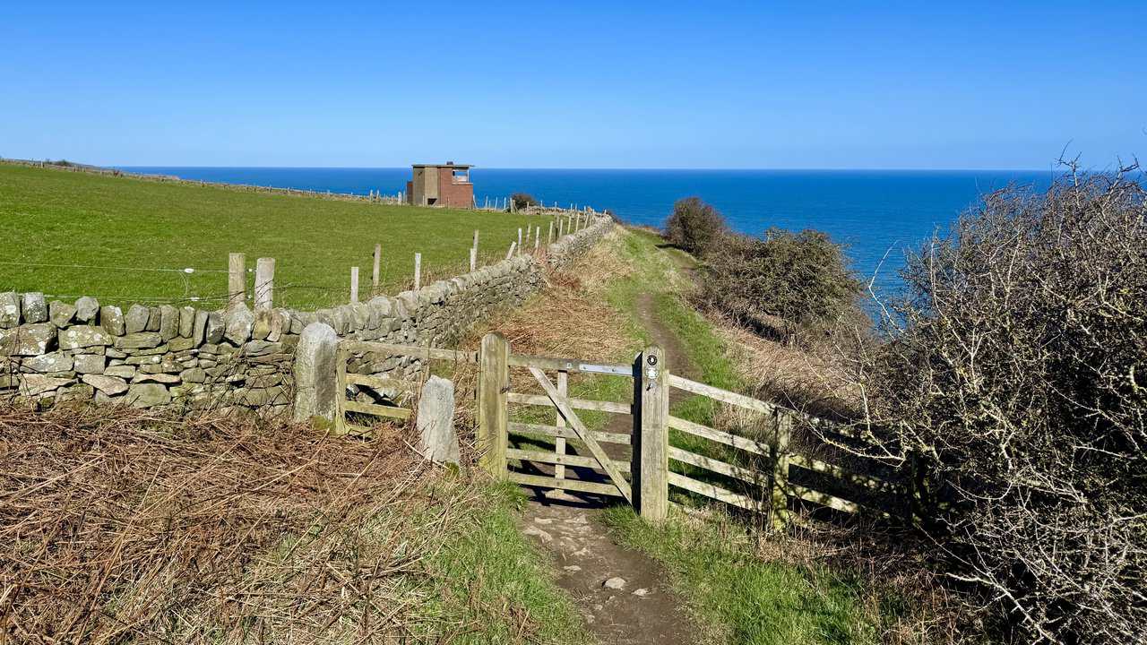
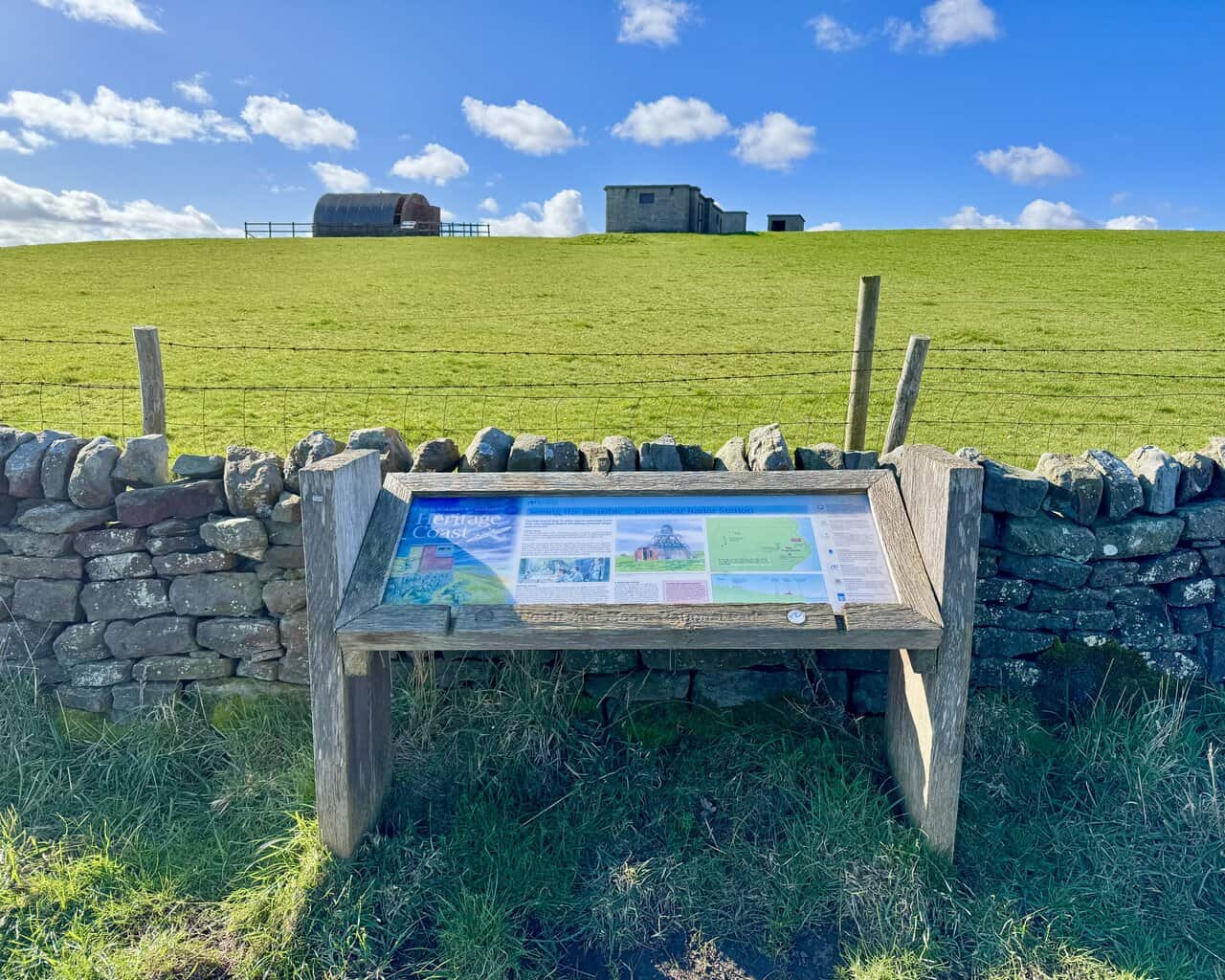
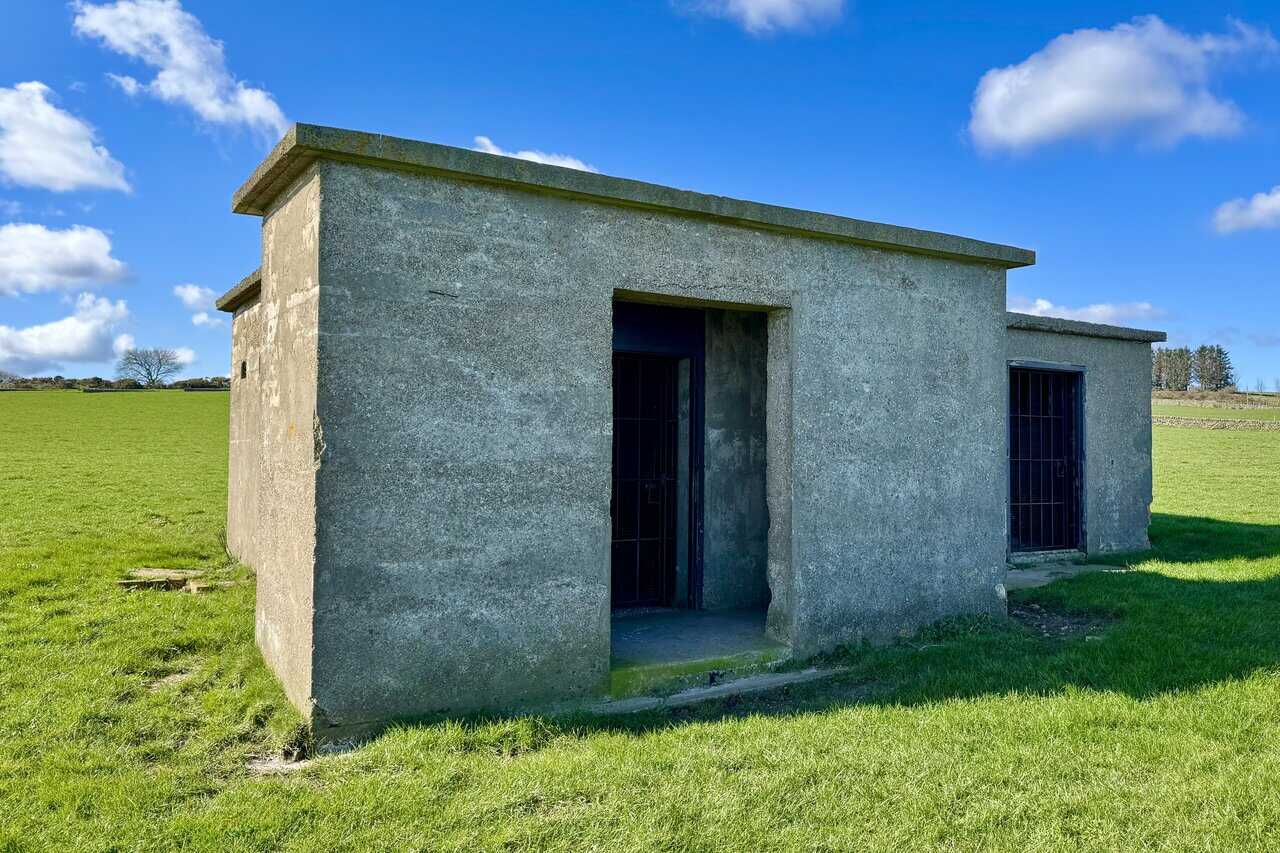
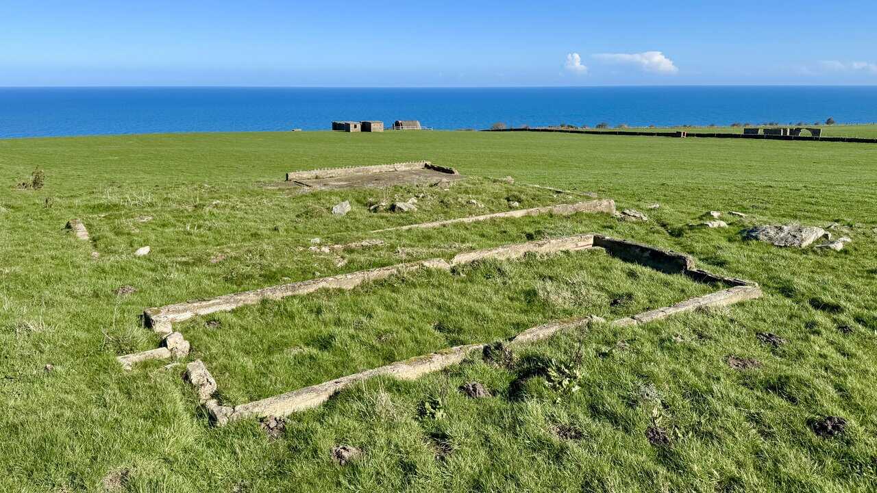
I first reach the Coastguard Station, a sturdy brick building perched right on the cliff edge with its windows looking out across the sea, keeping watch over the shipping lanes below. Behind it, the path opens into a field where the remaining buildings of the Radar Station come fully into view. The radar equipment was housed here at the bottom of the field, while 35 men and one officer lived in accommodation buildings that once stood at the top of the hill, close to the former Scarborough and Whitby Railway, now known as the Cinder Track.

The shells of the buildings that remain follow the standard plan for radar stations built across the UK during the war. The main operational part of the site was the cluster of buildings in the field behind the Coastguard Station, close to the cliff edge. These included the Communications Hut, the Transmitter and Receiver Block, the Fuel Store, and the Engine House, which housed the generator that kept the station running. Together, they formed the working heart of the installation, from which the radar signals were sent and received.
ADVERTISEMENT
Further up the field stood the Accommodation Buildings, where the station crew lived and slept. I’ll take a closer look at those on my return, after visiting Ravenscar and following the Cinder Track back. The Ravenscar Radar Station became part of the National Trust estate in 1986, and today its historic value and significance are much more widely appreciated. The site is now specially protected as a Scheduled Ancient Monument, ensuring that this remarkable piece of wartime history is preserved for future generations.
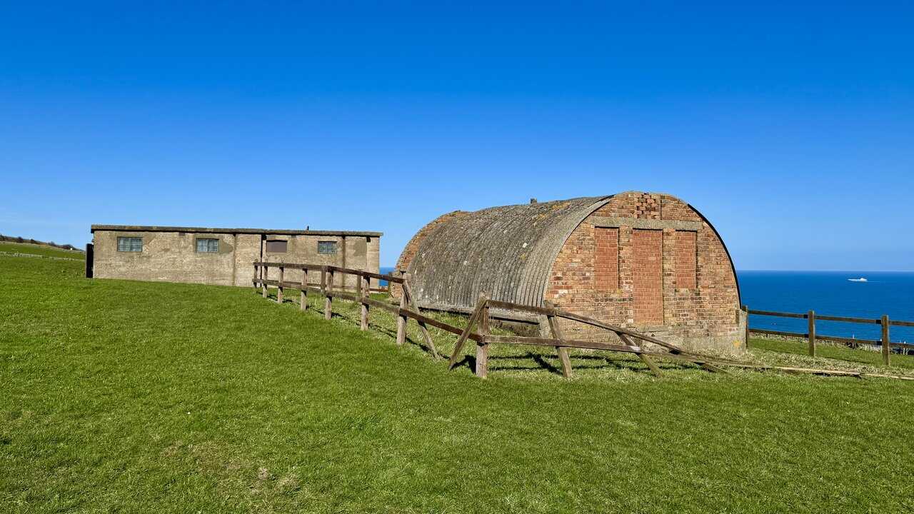
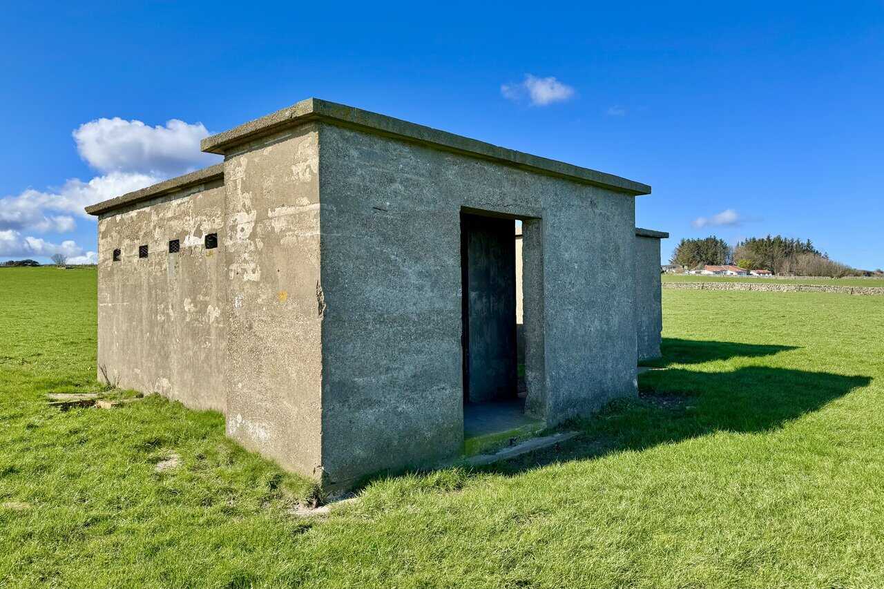
The first building I look at closely is the Communications Hut, a single-storey, three-cell brick building with a distinctive barrel-shaped corrugated roof. It was here that radar operators tracked enemy aircraft formations and monitored the movements of British aircraft. Each watch lasted five hours, with operators, mechanics, and officers working around the clock in shifts to maintain constant surveillance of the skies.
It is hard to overstate how significant radar technology was considered to be during the Second World War. Until Robert Watson-Watt developed radar in the mid-1930s, there had been no reliable way of knowing whether enemy aircraft were approaching until they could actually be seen or heard. Working at Bawdsey Manor and Orford Ness on the Suffolk coast, Watson-Watt and his small team of scientists proved that radar could detect the range of an aircraft, and by 1939 this had been developed into the Chain Home early detection system. After the war, Ravenscar was eventually replaced by RAF Fylingdales, the radar base and early warning system that still operates a few miles inland on the North York Moors.
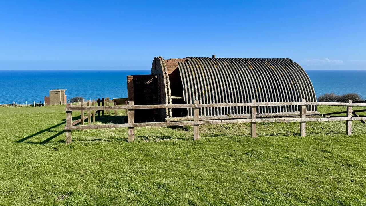
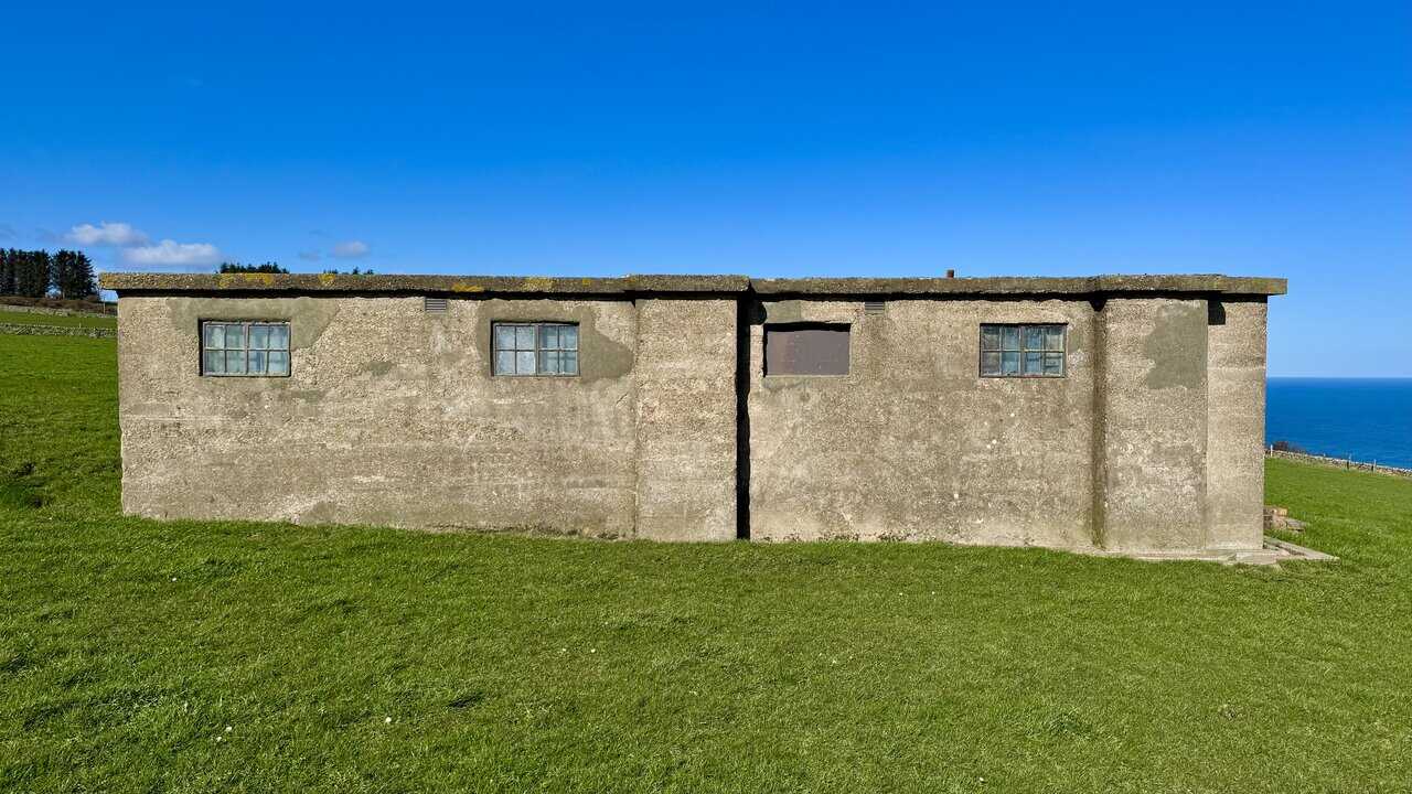
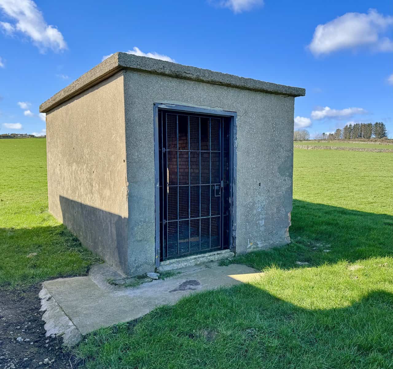
Next to the Communications Hut stands the Transmitter and Receiver Block, known as the Tx/Rx Block, a single-storey, three-cell building of reinforced concrete and brick with a flat concrete roof. This was the operational heart of the station, where radar information was plotted and processed. Acting with speed and accuracy was essential: coordinates from the Tx/Rx Block were telephoned to a Filter Room, where information was collated and corrected before being passed to a Fighter Command Group, ready to scramble squadrons to intercept enemy aircraft.
ADVERTISEMENT
Inside the Tx/Rx Block, it is still possible to see the remains of blast shutters fitted to the windows, a reminder that the station itself was considered a potential target for enemy attack. The building worked by sending out a very short pulse of radio signal to bounce off aircraft. Timing the echo and multiplying it by the speed of light revealed precisely how far away the aircraft was, a remarkably simple principle that proved to be one of the most decisive technological advantages of the entire war.
A short distance from the Tx/Rx Block stands the Fuel Store, a single-storey, single-cell brick building with a flat concrete roof. Inside, it housed the diesel tanks that kept the station’s generator running. It was positioned deliberately apart from the Engine House and other buildings to minimise the risk of fire spreading if it were struck by enemy artillery.
Concealment was a constant concern at sites like this one. Structures within radar station complexes were often camouflaged to avoid detection from the air, and at Ravenscar the open terrain meant the buildings would have been clearly visible both from enemy aircraft and from the nearby railway line. Rumour has it that farmers were paid to graze their sheep close to the buildings in order to fool enemy surveillance missions into mistaking them for ordinary farm outbuildings. Whether or not it worked, it speaks volumes about the ingenuity of those responsible for keeping the station hidden and operational.
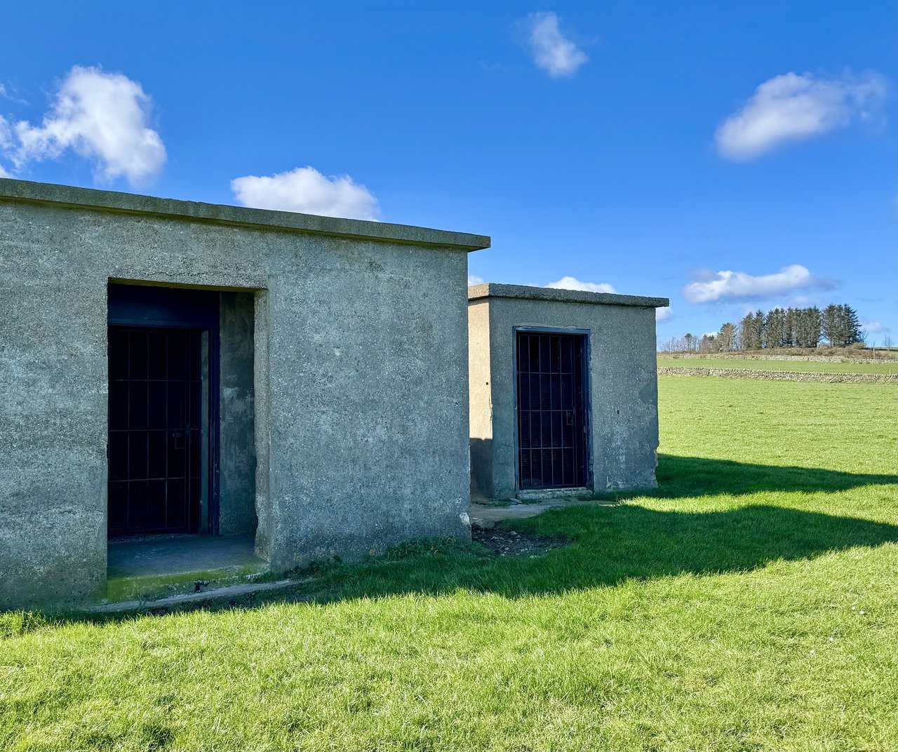
The final building in this cluster is the Engine House, also known as the Standby Set House, a single-storey building of reinforced concrete with a flat concrete roof and a large screened porch at the front. To function effectively, the radar station required a connection to the mains power supply, the telephone system, and access to a water source. The Engine House contained a generator to provide an emergency back-up power supply for the Tx/Rx Block in the event of a mains failure, ensuring the station could continue operating without interruption at any hour of the day or night.
ADVERTISEMENT
Looking around the interior of the Engine House, it is still possible to make out the outline of the machine bed on the floor, which once supported the generator. Vents in the walls, positioned at different heights on both the inside and outside of the building, allowed air to circulate and were probably designed to offer some protection in the event of an explosion. Standing here, it is not difficult to imagine the noise and heat of the engine running through the night, keeping the radar equipment alive while operators in the Tx/Rx Block watched the screens for any sign of an approaching enemy.
Leaving the radar station behind, I continue north along the clifftop path with the cliffs rolling away steeply to the sea on my right. Looking ahead, the cliffs on the northern side of Robin Hood’s Bay are clearly visible on the horizon, roughly four miles away. It’s a magnificent stretch of walking, with a real sense of space and remoteness.
Looking down from the cliff edge, the slope falls away sharply through scrub and rough grass to the rocky shore far below. At around 146 metres (480 feet) above sea level, these are high cliffs, and the view down to the sea is genuinely dramatic. The water is a deep, clear blue, washing gently against the base of the cliffs, a powerful reminder of just how wild and exposed this coastline truly is.

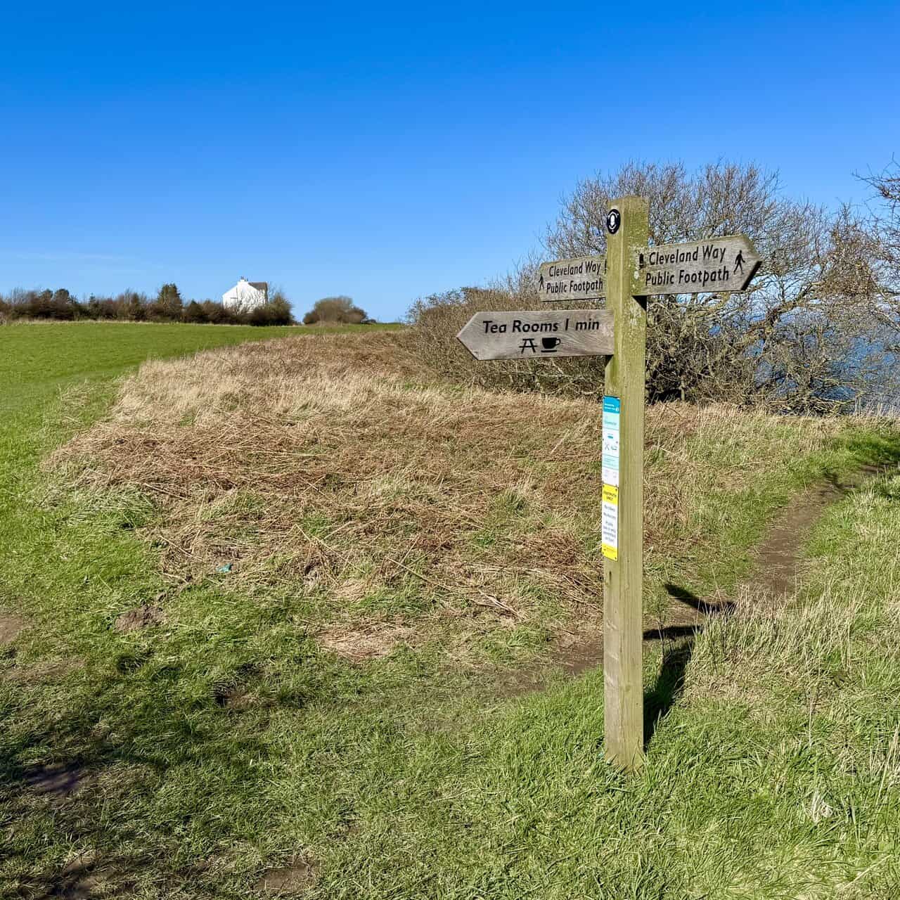
As I approach Ravenscar, a signpost marks a junction on the path. One arm points enticingly towards tea rooms just one minute away to the left, but I press on straight ahead along the Cleveland Way for now. The tea rooms will have to wait, as they make a very welcome stop later on the Hayburn Wyke walk, and the thought of a warm drink is a fine incentive to complete this next stretch of the route.
ADVERTISEMENT
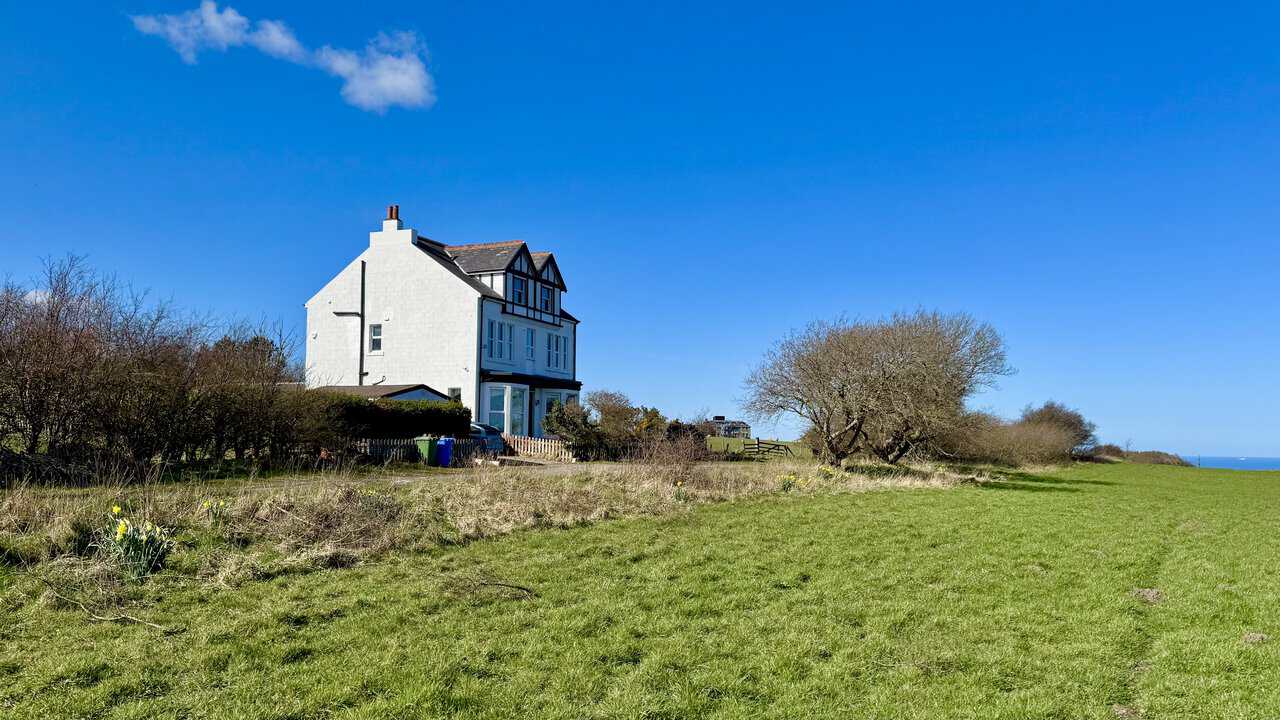
A short distance further along the path, a large white Victorian house comes into view, sitting in splendid isolation on the clifftop with the North Sea visible beyond. Built in 1899, it’s a handsome and substantial property, with its distinctive timber-framed gable giving it a classic late-Victorian character. It must have one of the finest and most dramatic settings of any house on this stretch of the North Yorkshire coast.
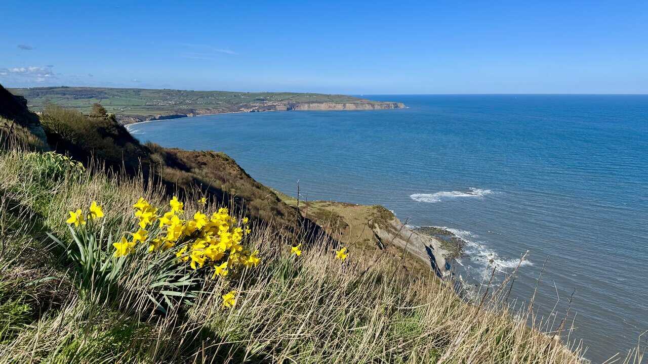
Just beyond the Victorian house, the clifftop opens up to reveal a dramatic view of the sheer rock face dropping steeply to the sea below, with the headland on the northern side of Robin Hood’s Bay just coming into view on the horizon. The cliff here is particularly striking, its dark, vegetation-covered face plunging vertically to the rocky shore, with seabirds wheeling overhead in the clear blue sky.
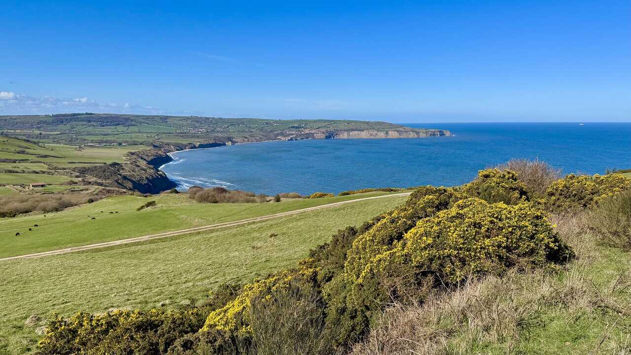
A few steps further and the view opens up fully, with Robin Hood’s Bay sweeping magnificently into view across the water. The village itself is just visible nestled beneath the cliffs in the far distance, and the long arc of the bay stretches away to the north in a scene of real grandeur. It’s the finest view of Robin Hood’s Bay so far on the walk, though I know an even better one awaits as I continue on towards Ravenscar.
The path brings me past the rear of the Raven Hall Hotel, a substantial and historic building with a fascinating past. Originally built in 1774 by Captain William Childs, the owner of the local alum works, it was opened as a hotel in 1895 following a major extension project. The hall was later owned by Dr Francis Willis, physician to King George III, and it is reputed that the king himself stayed here during his treatment. Today, the hotel sits within 100 acres of grounds on the clifftop overlooking Robin Hood’s Bay, with the Cleveland Way passing right through its estate.
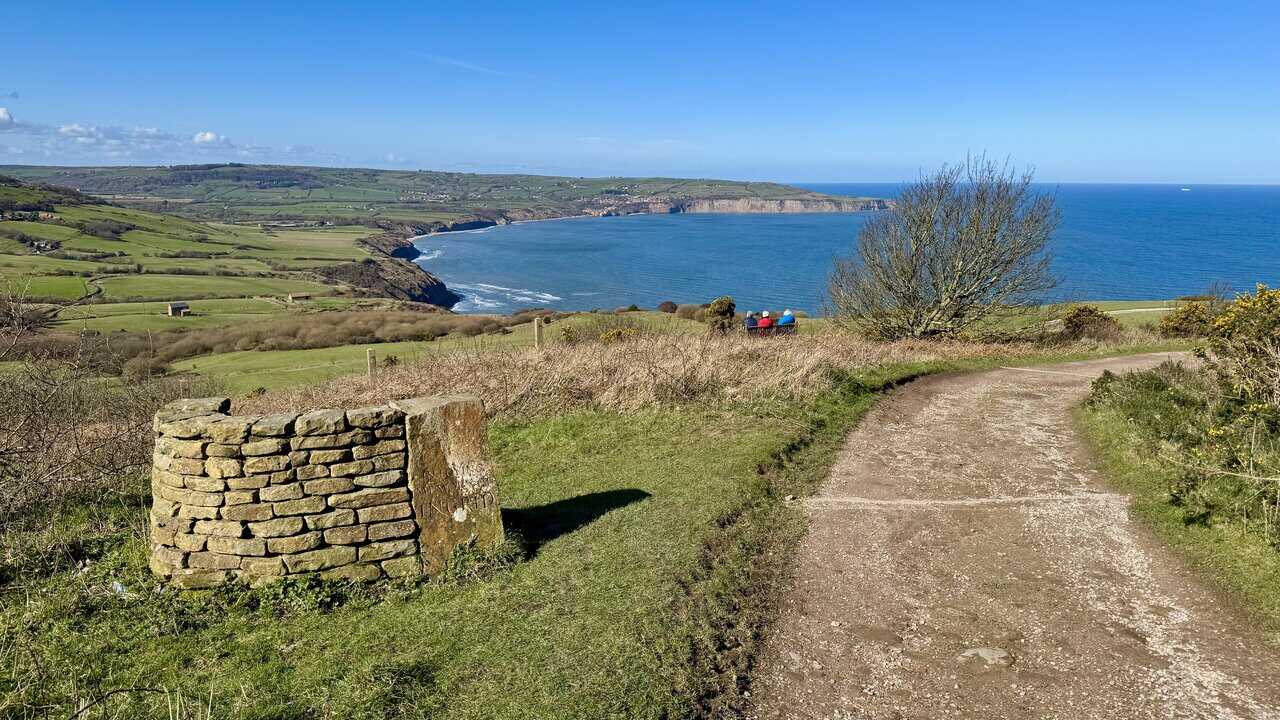
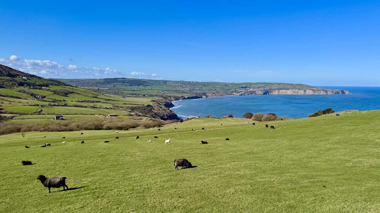
From Station Road in Ravenscar, I follow the path in front of the Raven Hall Hotel and begin to descend towards the golf course, where the view across Robin Hood’s Bay opens up in the most breathtaking fashion. A group of visitors are already seated on a bench, taking in the scene, and it’s easy to see why they stopped. This is without question the finest view on the Hayburn Wyke walk, with the full sweep of the bay laid out before me and the village of Robin Hood’s Bay just visible beneath the headland on the far side of the water.
ADVERTISEMENT
The path continues to descend, with gorse bushes lining the route and the great wide arc of Robin Hood’s Bay stretching out below. The green fields of the North Yorkshire countryside roll down to the cliffs on the far side of the bay, with the headland beyond standing proud against a clear blue sky. It’s a view of remarkable breadth and grandeur, and one that deserves to be taken in slowly.
Lower down, the path passes through the hotel’s golf course, where a flock of sheep graze contentedly across the vivid green fairways with Robin Hood’s Bay as their backdrop. The village is now clearly visible on the far side of the bay, its buildings clustered beneath the cliffs on the far headland. It’s a scene of real beauty, combining the pastoral tranquillity of the North Yorkshire countryside with one of the finest coastal panoramas in England.
Returning to Station Road, I pass the neat brick building of the Ravenscar Coastguard Rescue Team. This specialised volunteer unit forms part of HM Coastguard UK, providing a 24-hour emergency response service on this stretch of the North Yorkshire coast. The team specialises in cliff rescues, coastal searches, and water rescues, often working alongside the Scarborough and Whitby teams to assist with incidents involving treacherous terrain, falling rocks, or visitors stranded by the tide.

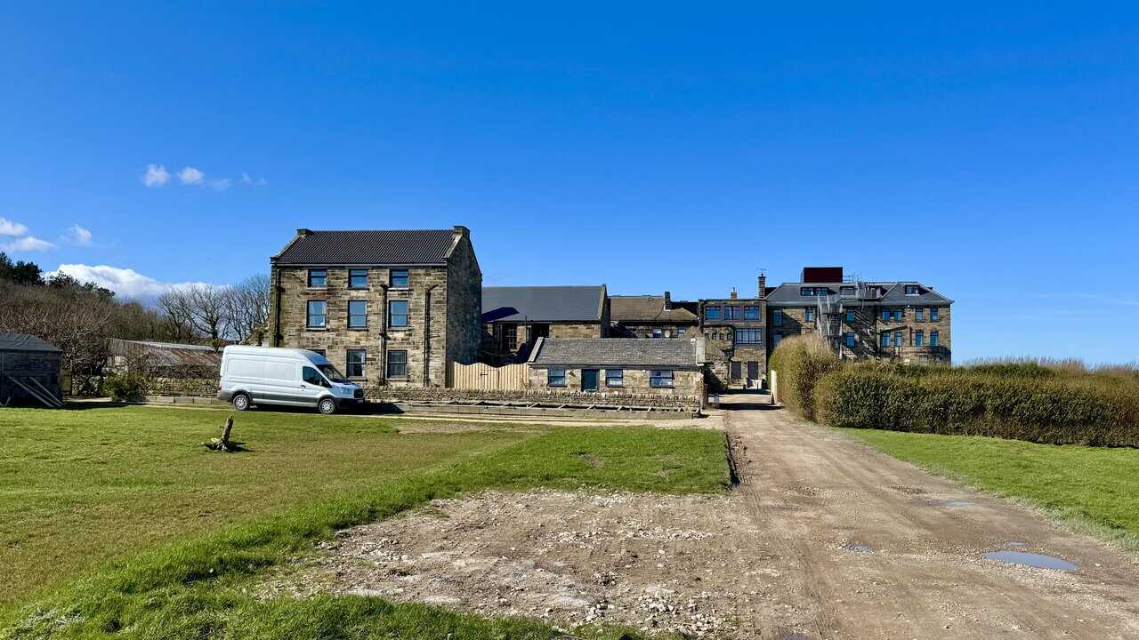
From Station Road, I walk past the Ravenscar Tea Rooms and across the old station area towards the former railway platform. Looking back, the tea rooms and surrounding buildings make a fine sight in the sunshine, their mix of brick and render giving them a pleasantly well-worn, characterful appearance. The tea rooms are a traditional, independently run café, popular with walkers and cyclists, offering both indoor seating and outdoor tables.
I join the Cinder Track at the old Ravenscar station platform, a reminder that this clifftop village was once connected to the railway line between Scarborough and Whitby. Ravenscar marks the halfway point between those two towns, and as the twentieth century began there were ambitious plans to develop it into a seaside resort to rival them both. Streets were laid out and sewers were built, but very few plots were ever sold and the enterprise collapsed, leaving Ravenscar as the ghost town that never was. Much of the land around here is now owned and cared for by the National Trust, and a small but excellent visitor centre in the village tells the full story of this fascinating area.

ADVERTISEMENT
The Cinder Track follows the route of the former Scarborough and Whitby Railway, which takes its name from the cinders used to lay the track bed rather than the usual crushed stone. The line opened in 1885 and closed in 1965, and today the route provides over 21 miles of coast and countryside to explore on foot, by bike, or on horseback. It never strays more than a mile or so from the sea, passing through several villages and eight former station stops, making it easy to enjoy in manageable sections.
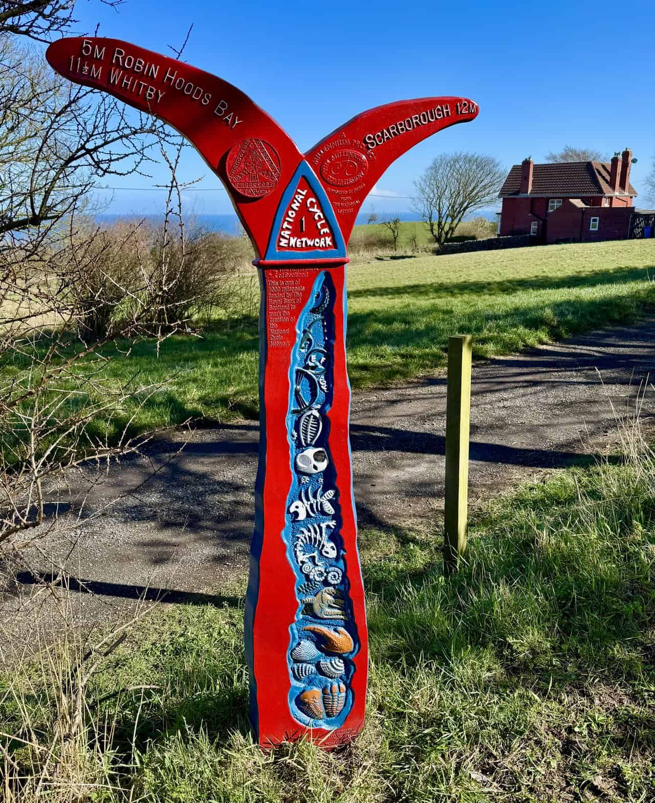
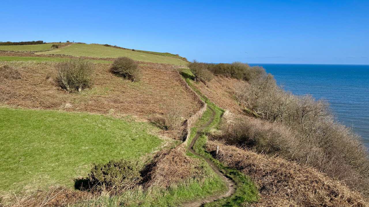
Heading south along the Cinder Track towards Hayburn Wyke, the path is wide, level, and easy underfoot, bordered by dry stone walls and open farmland with the sea visible to the left. The track forms part of National Cycle Network Route 1 and is popular with walkers, cyclists, and horse riders alike. It’s a wonderful contrast to the clifftop path walked earlier in the day, and a thoroughly enjoyable way to complete the return leg of the Hayburn Wyke walk.
A short distance along the Cinder Track, I pass the site of the Accommodation Buildings that once housed the crew of the Ravenscar World War II Radar Station. There were probably four main buildings here, likely Nissen huts of curved corrugated steel and iron sheeting over a semicircular frame with brick end walls, each measuring around 11 metres by 5 metres. Airmen slept twelve to a room, sergeants eight, and senior officers had four rooms each, while women stationed here had their own separate accommodation and washhouse. Most of the buildings were demolished between 1944 and 1946 once the station had been decommissioned, and today very little remains to mark the spot.
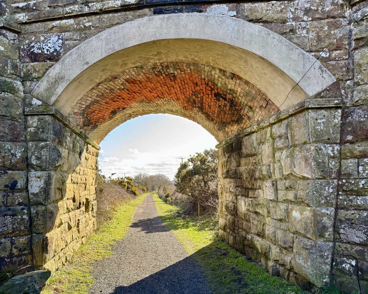
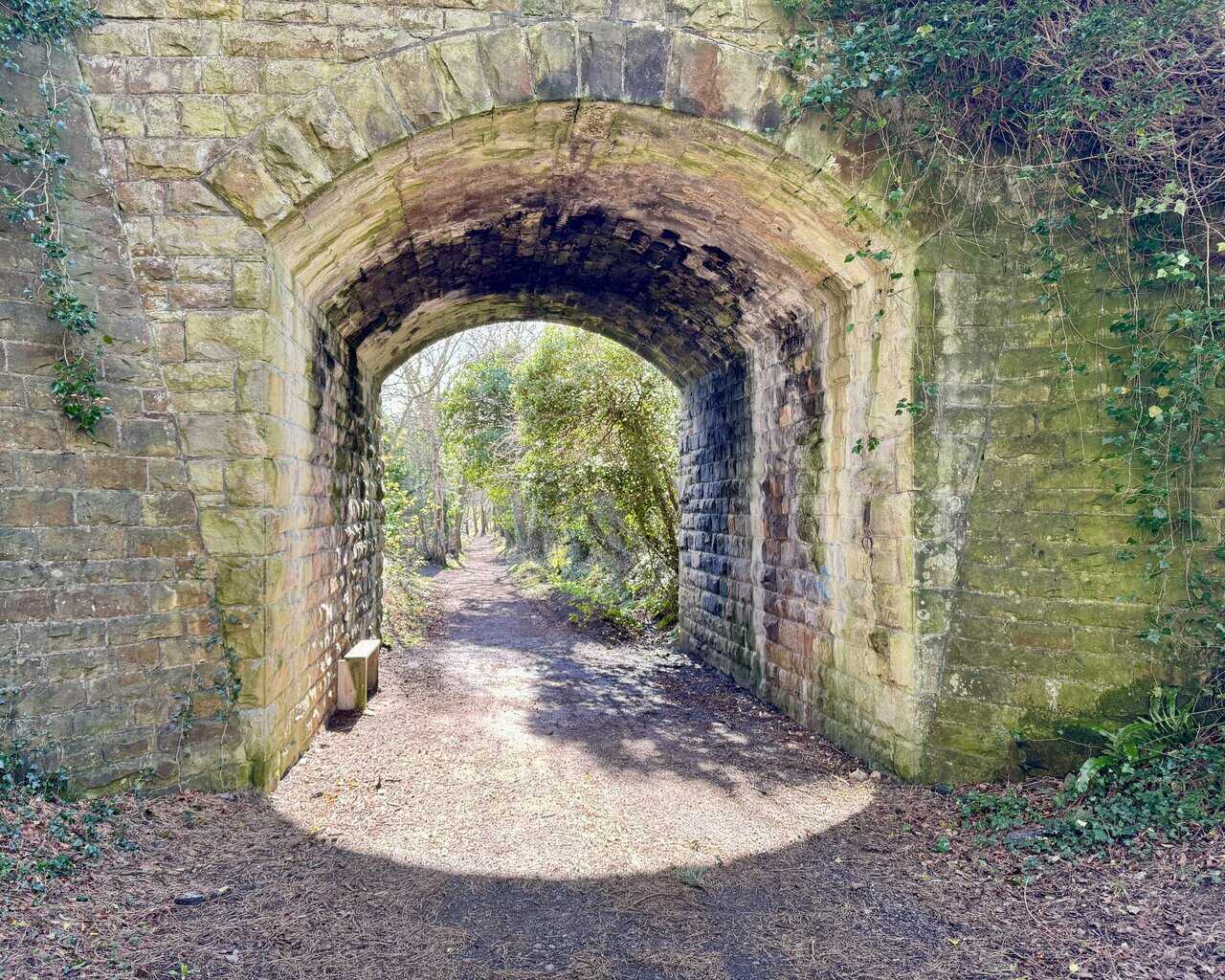
About three quarters of a mile south of Ravenscar, the Cinder Track passes beneath Bent Rigg Lane through a handsome stone-built tunnel. The arch is beautifully constructed, with a ring of warm red brick set within the larger stonework, and the path stretches away invitingly beyond. It’s a lovely feature of the old railway line and a reminder of the craftsmanship that went into building this route back in the 1880s.
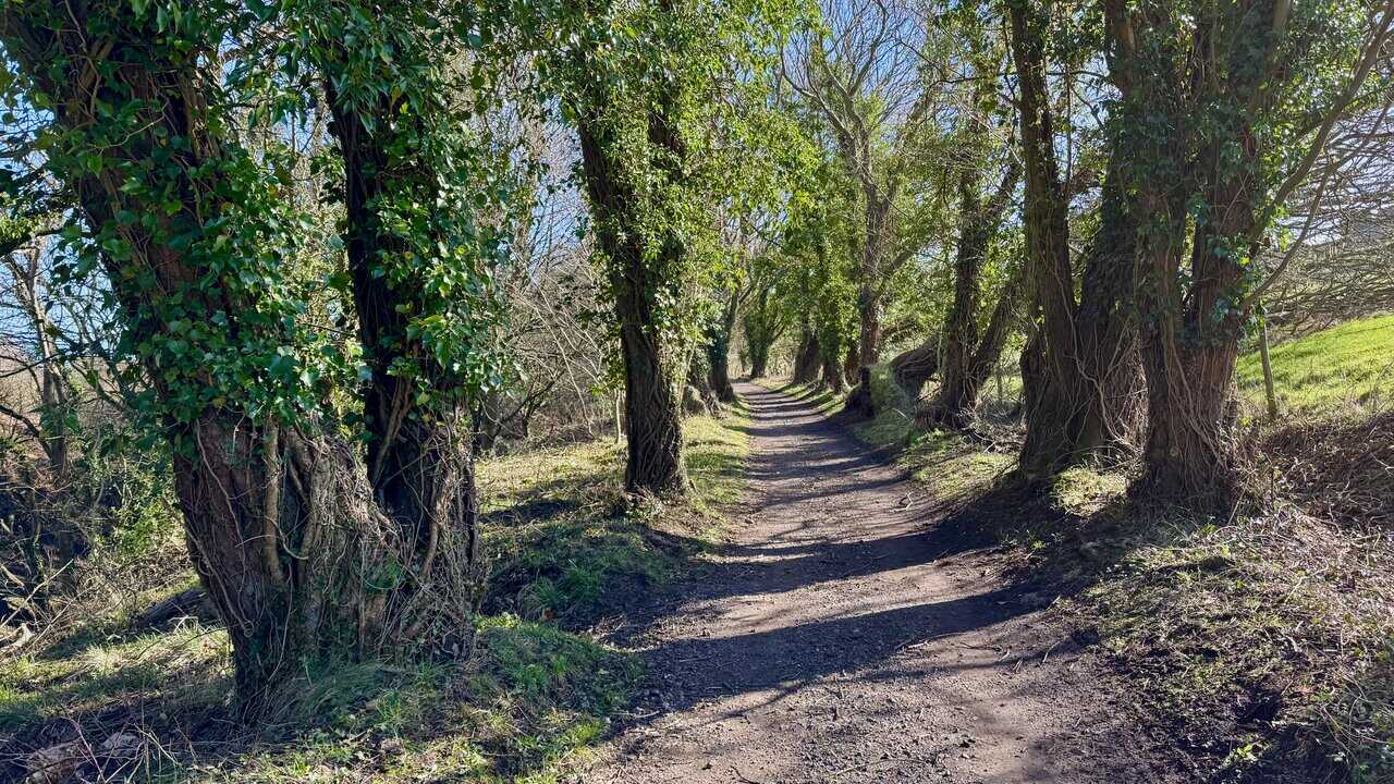
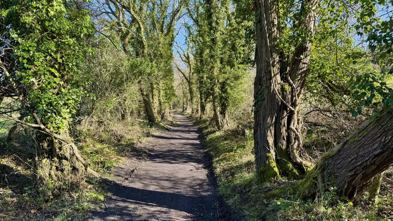
A mile further south, the Cinder Track passes through a beautiful tree-lined section where the old railway cutting creates a natural avenue of mature trees on either side of the path. The branches arch overhead, filtering the light and giving the track a quiet, sheltered character that feels quite different from the open clifftop walking earlier in the day. It’s one of the most attractive sections of the Hayburn Wyke walk, and a peaceful contrast to the exposed coastal path walked outward.
ADVERTISEMENT
About two thirds of a mile further along the Cinder Track, I pass the former Staintondale Railway Station, now a beautifully maintained private house sitting alongside the old line. The station opened on 16 July 1885 with the Scarborough and Whitby Railway, serving the scattered hamlet of Staintondale and the surrounding farms on this high stretch of coast. It had two platforms, both of which are still clearly visible, and by 1904 it was recorded as handling general goods, livestock, horse boxes, and prize-cattle vans.
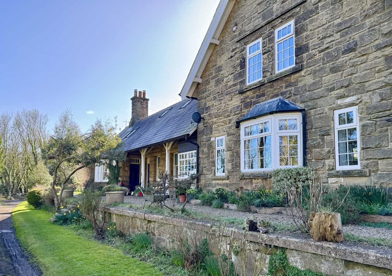
The station passed through the hands of the North Eastern Railway, the LNER, and finally British Railways, carrying local passengers, holiday traffic, and farm produce between Scarborough and Whitby throughout its working life. Like so many rural stations, it eventually became uneconomic, and Staintondale closed to all traffic on 8 March 1965 as part of the Beeching cuts. Today, the stone building looks in fine condition, a handsome reminder of the railway age that once brought life and commerce to this quiet corner of the North Yorkshire coast.
Shortly after passing the former station, the Cinder Track passes through another fine stone tunnel, this one carrying the lane that links Bridge Farm and Whitehouse Farm overhead. This tunnel has a slightly different character to the one at Bent Rigg Lane, built entirely in stone with ivy and vegetation creeping across its outer face, giving it a more weathered appearance. The track continues into a leafy, sheltered section beyond, the tree canopy closing in on either side.
Beyond the tunnel, the Cinder Track continues south through another lovely tree-lined section, the path forming a natural corridor of mature trees draped in ivy, their trunks moss-covered and gnarled with age. With roughly a mile still to go, the walking remains easy and pleasant, the flat, well-surfaced track making for a comfortable final stretch. It’s a fitting conclusion to the Hayburn Wyke walk, with the Hayburn Wyke Hotel and the car park waiting just ahead at the end of the route.
ADVERTISEMENT