ADVERTISEMENT
Explore the Penhill Walk from West Witton in the Heart of Wensleydale
Start your Penhill walk at the roadside car park on the A684, located on the eastern side of West Witton. From the car park, walk along the grass verge beside the main road, heading back towards the village. Ignore the first public footpath on your left, signposted to Common Lane. Continue past a few cottages on your left until you see a public footpath signposted to Capple Bank. This path runs between two cottages, Valley View and Fold Cottage.
Emerging into open countryside, follow the footpath diagonally across several fields in a south-easterly direction. The trail may not always be clear, but aim to approach the eastern grassy slopes of Capple Bank in the far distance. After approximately three-quarters of a mile (1.2 kilometres), you will intersect another footpath. This second path is also subtle, but you will recognise it as the slopes of Capple Bank start to diminish, revealing an area of exposed rocks. Turn right here and follow the path south, ascending between the rocks before continuing through the centre of a large square field.
At the far side of the field, head straight towards the woodlands of Capplebank Plantation. Cross the stile and climb the steep stone steps through the woodland. At the top, you will meet a minor tarmac road. Turn right and follow this road for about half a mile (800 metres) to reach Penhill Farm. This point marks roughly one-quarter of the way round your Penhill walk.

ADVERTISEMENT
At Penhill Farm, turn left and continue uphill along the minor road for one-third of a mile (500 metres). Look for a bridleway on your right, signposted to Penhill. Follow this well-defined bridleway as it gently ascends towards the summit of Penhill. On a clear day, you will see the stone shelter at the top, which serves as your next landmark. After nearly three-quarters of a mile (1.2 kilometres), you will reach the base of a steeper section. Although the grassy bridleway curves to the left, it is best to climb directly up the slope, following the path through grooves cut into the hillside.
At the summit, you will arrive at the stone shelter commemorating the reign of Queen Elizabeth II. From here, follow the path towards the northern edge of the hill to Penhill Beacon, a grassy mound of rocks. Continue west along the path, staying near the top of the slopes. The trail leads across Penhill Scar; keep the dry stone wall on your left for guidance.
As you approach Black Scar, you will come to a large gate in the dry stone wall. Do not pass through it. Instead, turn right opposite the gate and follow the flagged stone path downhill. This path zigzags through the disused tips and levels of the former Penhill Quarry, marking the halfway point of your Penhill walk.

ADVERTISEMENT
At the bottom, the path meets a public footpath. Follow it west, then south, descending further to reach a wide stone track near Stony Gate. Turn left and walk along this track for half a mile (800 metres). Then, turn right onto another stone track enclosed by dry stone walls. Continue on the track to a concrete road, which descends and bends sharply left. At the next bend, leave the concrete road and take the public footpath across a field, signposted to Temple Farm.
Follow this path downhill to the remains of the Penhill Preceptory. This historic site marks three-quarters of the way around your Penhill walk. After exploring the preceptory, turn right and take the grassy path east along the edge of Long Bank Wood. Continue for about a mile (1.6 kilometres), following signs for West Witton.
As you near the A684, the path leads diagonally across three fields to the right-hand corner of a woodland area. From here, continue to the main road on the western side of West Witton. Walk through the village along the road to return to the car park, completing your Penhill walk.
This scenic trail in Wensleydale, part of the Yorkshire Dales, offers a memorable trek of just over 8 miles (13 kilometres). Along the way, you’ll encounter breathtaking views, diverse landscapes, and fascinating landmarks, including the historic Penhill Preceptory, which adds a touch of medieval intrigue to your journey. Enjoy every step of this rewarding and picturesque adventure!
Penhill Walk: Maps and Tools
Visit either the OS Maps website or the Outdooractive website to view this walking route in greater detail. Both platforms offer a range of features, including the ability to print the route, download it to your device, and export the route as a GPX file. You can also watch a 3D fly-over and share the route on social media. Additionally, this page includes a printable version of the walk in PDF format. Plus there is a supporting video, available for you to watch on YouTube.
Penhill Walk: Distance, Duration, Statistics
Distance: 8¼ miles
Distance: 13¼ kilometres
Duration: 4 hours
Ascent: 1316 feet
Ascent: 401 metres
Type: Circular walk

ADVERTISEMENT
Recommended Ordnance Survey Map
The best map to use on this walk is the Ordnance Survey map of the Yorkshire Dales Northern & Central Area, reference OS Explorer OL30, scale 1:25,000. It clearly displays footpaths, rights of way, open access land and vegetation on the ground, making it ideal for walking, running and hiking. The map can be purchased from Amazon in either a standard, paper version or a weatherproof, laminated version, as shown below.
Standard Version
Yorkshire Dales Walking Guidebooks
Walking in the Yorkshire Dales: North and East, by Dennis Kelsall, describes 43 circular day walks of 3 to 12 miles across the Howgills, Mallerstang, Swaledale, Wensleydale, Coverdale and Nidderdale, with Ordnance Survey mapping and notes on parking and refreshments.
15 Short Walks in the Yorkshire Dales, by Jonathan and Lesley Williams, covers the area around Sedbergh, Kirkby Lonsdale and Ingleton. Its 15 routes of 1 to 7 miles each take under three hours, ideal for families or a relaxed half day out. Both books can be purchased from Amazon, as shown below.
Walking the Yorkshire Dales
About Penhill
Penhill stands at 526 metres (1726 feet) above sea level at the triangulation pillar near Penhill Scar, located at the eastern end of the hill. Its highest point, known as Height of Hazely, reaches 553 metres (1814 feet) at the western side. This ridge dominates the skyline, forming a striking natural boundary between Wensleydale to the north and Coverdale to the south. Its distinctive concave shape was sculpted during the last Ice Age, as glaciers carved Wensleydale into the classic U-shaped glacial valley seen today.
Just east of the triangulation pillar lies Penhill Beacon, standing at 514 metres (1686 feet). This green, turf-covered mound dates back to the reign of Elizabeth I, when beacons were lit across the country to warn of the Spanish Armada. The mound, which measures 10 metres (33 feet) in diameter and 1 metre (3 feet) in height, once featured a central stone block base measuring 5 metres (16 feet) square. These stones likely supported the beacon structure. Burnt debris from a Jubilee bonfire lit in 1977 remains visible as a reminder of its enduring historical significance.
Related Walk: Similar to the Penhill Walk
Explore Yorkshire’s Semer Water walk and the historic Roman Road
Nearby, you’ll find what was once a cairn, noted on Ordnance Survey maps as ‘Pile of Stones’. This structure has been rebuilt and transformed into a shelter by the Wensleydale Round Table. Their work commemorates the reign of Queen Elizabeth II, from 1952 to 2022. A plaque on the shelter reads:
Wensleydale Round Table
Commemorating the Reign of Queen Elizabeth II 1952–2022.
The name ‘Penhill’ is a pleonasm, combining the Brittonic word penn (meaning ‘hill’ or ‘head’) with the Old English hyll (also meaning ‘hill’). This repetition highlights the region’s rich linguistic history. Local legend adds a touch of mystery to the hill, telling of the Penhill Giant, a fearsome figure said to have stolen sheep from the surrounding flocks.
Penhill Walk: My Photos
After parking in the car park beside the main road, we begin our Penhill walk by heading into the village of West Witton. We ignore the first public footpath on the left, signposted to Common Lane, and pass a very large cream-painted house on our left-hand side.

ADVERTISEMENT
A little further along, we pass a few more cottages on our left. Shortly after, we take the second public footpath on the left-hand side. This path, signposted to Capple Bank, runs between two charming cottages called Valley View and Fold Cottage.

The footpath guides us diagonally across several fields in a south-easterly direction towards Capple Bank. Ahead, we know we will meet a second public footpath, where we will turn right and head directly south into Capplebank Plantation. This woodland is visible on the horizon in this photograph.

ADVERTISEMENT
The path south up Capple Bank isn’t immediately obvious, but we manage to find our way. Eventually, we reach the edge of Capplebank Plantation. Here, we cross a stile and ascend steep steps through the woods. This section of our Penhill walk is steep and invigorating, leaving our hearts pumping by the time we reach the top.

Emerging from the woods after our climb, we arrive at a minor road—a welcome change of pace. From this point, Penhill dominates the skyline ahead. That is where we are heading!
ADVERTISEMENT
The main road towards Penhill Farm runs alongside a large field used for gallops. A public footpath crosses the field, giving us a perfect opportunity to capture a quick photograph of the gallops before continuing.

After the steep climb through Capplebank Plantation, this stretch along a quiet country road feels like a relaxing stroll. Penhill remains our constant focal point, visible in the distance, as we make our way towards Penhill Farm.

ADVERTISEMENT
We reach Penhill Farm, a distinguished equestrian property set in the heart of the Yorkshire Dales National Park.

Turning left, we continue along the quiet road that runs in front of Penhill Farm. The farm comprises a traditional stone-built detached farmhouse, a large two-storey barn, and a substantial hangar-like building used to stable horses.

ADVERTISEMENT
The farm’s gallops stretch across Middleham High Moor, known locally as Middleham Gallops. The day is beautifully clear, allowing us to take in the expansive views across the moorland.

After walking south uphill along the minor road from Penhill Farm, we turn right and follow a bridleway leading across the moors.

The bridleway is a well-defined track that gently ascends. It takes us across fields, through gates, and between gaps in the dry stone walls, making for straightforward navigation.

ADVERTISEMENT
As we follow the grassy bridleway towards Penhill, we pause now and then to look back and marvel at the breathtaking views of the surrounding Wensleydale countryside.

Our Penhill walk continues to delight. Even though we are climbing steadily uphill, the gradient is gentle and far less demanding than we originally anticipated.

The summit looms ever closer, and with it, the final, much steeper ascent. It’s a clear day and the stone shelter, where we are heading, is visible on the left-hand side of the hill.

ADVERTISEMENT
As the bridleway curves to the left, we opt for the direct route uphill towards the stone shelter. Following one of the grooves etched into the hillside, we muster our energy and begin the climb.

Reaching the stone shelter is a triumph. From here, the views over Wensleydale are truly stunning. Marked as ‘Pile of Stones’ on the Ordnance Survey map, this shelter was rebuilt and enhanced by the Wensleydale Round Table. Their work commemorates the reign of Queen Elizabeth II, from 1952 to 2022. A plaque on the shelter reads:
Wensleydale Round Table
Commemorating the Reign of Queen Elizabeth II 1952–2022.

A little further along, we reach the location known as Penhill Beacon. At an elevation of 514 metres above sea level, the views here are nothing short of spectacular. Visible landmarks include Leyburn, West Witton, Preston-under-Scar, Castle Bolton, and many others.
ADVERTISEMENT
Penhill Beacon is a green, turf-covered mound believed to date back to the reign of Elizabeth I at the time of the Spanish Armada threat. The mound measures 10 metres in diameter and one metre high. At its centre, remnants of a 5-metre square stone block base may have supported the beacon. Burnt debris from the 1977 Jubilee bonfire is still visible.

Walking along the path from Penhill Beacon, we enjoy exceptional views of Penhill Scar, a rocky outcrop. Below lies Penhill Crags, a rugged area scattered with rocks and boulders. This is a highlight of our Penhill walk.

As we continue along the path above Penhill Scar, we notice a triangulation pillar on the opposite side of the wall. It stands at 526 metres, marking one of the high points of our Penhill walk.

ADVERTISEMENT
The path above Penhill Scar is narrow but well-defined and easy to follow. With today’s clear weather, the views across Wensleydale are nothing short of extraordinary.

A little further along, just before Black Scar, we come across a gate in the dry stone wall on our left. Opposite this gate lies the paved stone path that will guide us downhill as we begin our descent.

The grassy path zigzags down the steep north-facing slopes of Penhill. The zigzag design makes the gradient manageable, and the path itself is well-maintained and comfortable to walk along.

As we make our way downhill, we pass through the remnants of Penhill Quarry. This area, with its disused tips and levels, offers an intriguing glimpse into the site’s industrial past.
ADVERTISEMENT
Leaving the quarry behind, we follow a grassy public footpath downhill towards Stony Gate. From this vantage point, we enjoy a spectacular view of Bolton Castle, perched on the northern side of the Wensleydale valley floor.

The grassy path gradually becomes a wider, stony track as we approach Stony Gate. This part of the Penhill walk is as pleasant as ever, with the surrounding countryside enhancing the experience.

Our descent provides us with sweeping views of the vibrant green fields below. These fields, divided by the iconic dry stone walls of the Yorkshire Dales, create a timeless and picturesque patchwork.

Beyond the fields, we can see the northern hillside of Wensleydale. Prominent landmarks such as Preston-under-Scar, the rocky Redmire Scar, and the historic Bolton Castle add depth to the view.

ADVERTISEMENT
From Stony Gate, we follow a wide stone track heading west. Shortly after, we turn north onto a walled track flanked by two trees. This route leads us towards the remains of the Penhill Preceptory.

This track guides us to the top of a bank, where we are treated to panoramic views of Wensleydale. Castle Bolton and the village of Redmire are particularly striking as they stand out amidst the breathtaking landscape.

From the top of the bank, we take a concrete lane downhill, which sweeps sharply to the left. A grassy footpath then leads us across fields, bringing us closer to the Penhill Preceptory.

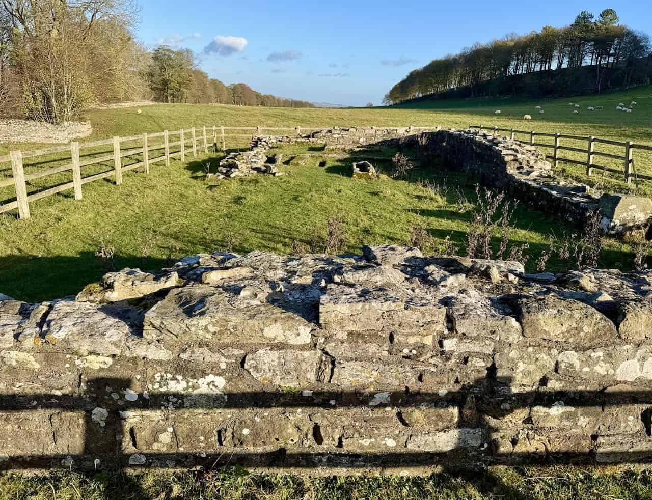
The Penhill Preceptory
At last, we arrive at the Penhill Preceptory. This historic site is a highlight of our Penhill walk, and it is protected as a monument of national importance under the Ancient Monuments Acts.

ADVERTISEMENT
The Penhill Preceptory was established around 1200 as a base for the Knights Templar. This military and religious order, founded in the early 12th century, played a significant role during the Crusades. The preceptory served as a local administrative centre, managing agricultural operations and supporting the Templars’ activities across the region.

Following the suppression of the Knights Templar in 1312, the Penhill Preceptory, along with other Templar properties, was transferred to the Knights Hospitaller. By 1328, however, records indicate that the Hospitallers considered the site worthless due to its dilapidated state. Over the centuries, the preceptory fell into ruin, and its precise location remained unknown until 1840, when the chapel’s remains were uncovered.

Today, visitors to the Penhill Preceptory can explore the exposed foundations of the chapel, which measure approximately 17.5 metres by 6.8 metres. Inside, three stone coffins and the base of the original altar are visible. While the adjoining residential buildings have not yet been excavated, the surrounding earthworks hint at their former presence.
Leaving the Penhill Preceptory, we take a grassy path heading east along the southern edge of Long Bank Wood. Occasionally, gaps in the trees offer fleeting views of Bolton Castle in the distance, adding to the charm of this part of our Penhill walk.

ADVERTISEMENT
Re-entering the village of West Witton, we pass the Remembrance Day memorial on the village green. At its centre stands a striking silhouette of a soldier draped in the Union Jack. This poignant tribute honours the soldiers who served in past conflicts.

As we continue through the village, we pass The Wensleydale Heifer. This historic 17th-century coaching inn has been transformed into a boutique hotel and seafood restaurant. For over 20 years, Lewis and David Moss, a father-and-son team, have owned and operated this beloved establishment. Their dedication to creating a warm, welcoming atmosphere has earned it a stellar reputation.

The Wensleydale Heifer is celebrated for its 13 themed rooms, which include designs such as ‘James Bond’, ‘Black Sheep’, ‘James Herriot’, and ‘All Creatures Great & Small’. Its commitment to culinary excellence and exceptional hospitality makes it a favourite among locals and walkers. Its blend of historical charm and modern luxury adds to its appeal.

A little further along the main road in West Witton, we pass Arkwright’s, the village store. Its name brings to mind the classic sitcom Open All Hours, and like many others passing by, we can’t help but wonder if it lives up to its name.

Our Penhill walk concludes with a stunning view northwards across the Wensleydale valley floor. From this vantage point, we can see the village of Preston-under-Scar nestled in the landscape. This final view provides a fitting and beautiful end to a rewarding journey.

ADVERTISEMENT
ADVERTISEMENT