Cliffs and Coastline Along the Robin Hood’s Bay Walk to High Hawsker
Start your Robin Hood’s Bay walk at Station Car Park in Robin Hood’s Bay. This is a long-stay pay and display car park with toilet facilities, and it has plenty of spaces. There is also an overflow car park if the main one is full. From the car park, make your way towards Fylingdales Village Hall and the doctor’s surgery. Walk past the village hall, keeping the old station buildings on your right, and continue straight ahead downhill to Thorpe Lane. Turn right onto Thorpe Lane and, shortly afterwards, turn left onto the Cinder Track.
Head south along the Cinder Track for about three-quarters of a mile, passing Middlewood Farm Holiday Park on your right. After the caravan park, turn left onto the tarmac lane signposted to Boggle Hole, then almost immediately turn left again onto Mark Lane. Bear left in front of the farmhouse, following the footpath signed to Robin Hood’s Bay and Boggle Hole. Continue along the path towards the coast, following the public path as it bears left, signposted Cleveland Way and Robin Hood’s Bay. Follow the flagged stone path and then go down a set of steps towards Robin Hood’s Bay. Halfway down the steps the path splits. Turn right if you want to go down to the café and beach, otherwise turn left. At the bottom of the steps, turn right onto the narrow lane which leads to New Road, then turn left.
Follow New Road uphill through Robin Hood’s Bay, between the shops and houses. At the top of the hill you’ll reach the cobbled roundabout in front of the Victoria Hotel. Follow Station Road past the front of the Victoria Hotel and other bed and breakfast establishments on your right. Continue along the road and you’ll reach The Grosvenor Hotel, also on your right. Soon after, turn right onto Mount Pleasant North, where you’ll see signs for the Cinder Track, the Cleveland Way and the Coast to Coast Path. Walk along Mount Pleasant North, following it as it bears around to the left uphill, keeping to the signs for the Cinder Track and the Cleveland Way. Turn right onto the Cinder Track, signposted Cinder Track and Cleveland Way to Whitby. After a short distance, when the path splits into two, take the right-hand fork and join the Cleveland Way and Coast to Coast Path towards Hawsker and Whitby.
Keep heading north along the Cleveland Way clifftop coastal path, which also forms part of the King Charles III England Coast Path. The route is very straightforward along this stretch. After about one and a half miles you’ll reach a small valley called Rain Dale. Ignore the left-hand permissive footpath to the Cinder Track and keep straight ahead on the Cleveland Way, signposted to Whitby. After about another mile you’ll reach an area called Limekiln Slack. Again, ignore the permissive footpath on your left, which leads up to the Cinder Track, unless you feel you’ve gone far enough and want a shortcut back. Instead, carry on straight ahead on the Cleveland Way clifftop path. You are now about halfway around your Robin Hood’s Bay walk.
A little further along there is another left-hand turn, a public footpath leading to Northcliffe Holiday Park. You’ll be able to see the caravans from here. This is another opportunity to rejoin the Cinder Track if you’d prefer a shorter route. Otherwise, keep following the Cleveland Way coastal path. The route dips down into a wooded valley, then climbs some steps back up the other side and onto the top of the cliffs. Shortly after, another small wooded ravine follows, with another descent, a footbridge crossing, and then a climb back up again.

Soon after that, turn left and follow a public footpath leading uphill along the edge of a grassy field beside a dry stone wall. Follow the path around to the farmhouse, then turn left, cross a cattle grid and begin walking inland on the broad stone track. Keep walking inland for about two-thirds of a mile and use the bridge to cross over the Cinder Track. Walk past the farm buildings on your right to reach the B1447 at High Hawsker, then turn left and walk towards The Hare and Hounds.
Follow the road through the village. It soon bends around to the left, signposted to Robin Hood’s Bay and Fylingthorpe. Follow the roadside footpath and grass verge out of the village. At the point where the road bends sharply to the right, follow Bottoms Lane straight ahead into Northcliffe and Seaview Holiday Parks. Ignore the right turn into Seaview Holiday Park and keep going straight ahead along Bottoms Lane. Soon afterwards, turn right onto the Cinder Track.
Follow the Cinder Track for about two and a half miles heading back towards Robin Hood’s Bay. Almost in Robin Hood’s Bay, the Cinder Track merges with the Cleveland Way. Continue forward, following the signpost for Robin Hood’s Bay. The houses of Robin Hood’s Bay will soon come into view. At this point, turn left and follow the Cinder Track down into Robin Hood’s Bay to rejoin Mount Pleasant North. Walk along Mount Pleasant North to the end, then cross the main road and continue straight ahead to return to the car park, completing your Robin Hood’s Bay walk.
Robin Hood’s Bay Walk: Maps and Tools
Visit either the OS Maps website or the Outdooractive website to view this walking route in greater detail. Both platforms offer a range of features, including the ability to print the route, download it to your device, and export the route as a GPX file. You can also watch a 3D fly-over and share the route on social media. Plus there is a supporting video, available for you to watch on YouTube.
Robin Hood’s Bay Walk: Distance, Duration, Statistics
Distance: 9¼ miles
Distance: 14¾ kilometres
Duration: 4¼ hours
Ascent: 945 feet
Ascent: 288 metres
Type: Circular walk

Walking in the Yorkshire Dales with 43 Circular Routes
AD This Cicerone guidebook includes 43 circular walks exploring valleys, hills, and moors between Kirkby Stephen and Pateley Bridge. With OS maps, local highlights, and routes ranging from 3–11 miles, it is a year-round companion for walkers of all abilities.
Recommended Ordnance Survey Map
The best map to use on this walk is the Ordnance Survey map of the North York Moors Eastern Area, reference OS Explorer OL27, scale 1:25,000. It clearly displays footpaths, rights of way, open access land and vegetation on the ground, making it ideal for walking, running and hiking. The map can be purchased from Amazon in either a standard, paper version or a weatherproof, laminated version, as shown below.
About Robin Hood’s Bay
Robin Hood’s Bay is one of the most distinctive villages on the North Yorkshire coast, a maze of narrow streets and red-roofed cottages tumbling down a steep hillside to the sea. Locally known simply as Bay or Bay Town, it sits within the North York Moors National Park, between Whitby to the north and Scarborough to the south. The village lies in the ancient parish of Fylingdales, a name believed to derive from the Old English word “Fygela”, meaning marshy ground. For anyone planning a Robin Hood’s Bay walk, the village and its surroundings offer a rich mix of history, geology and coastal scenery.
The origin of the name Robin Hood’s Bay remains uncertain, and there is little evidence that the legendary outlaw ever visited this stretch of coast. The earliest recorded reference dates from a letter written between 1322 and 1346 by Louis, Count of Flanders, to King Edward III, complaining that Flemish fishermen and their boats had been taken by force to “Robyn Oedes Bay”. By the 16th century, the settlement had grown from an inland hamlet at Raw to a thriving coastal community. Henry VIII’s topographer, John Leland, described it in 1536 as “a fischer tounlet of 20 bootes”, and by 1540 the village was said to have around fifty cottages by the shore, making it a sizeable settlement for the time.
Smuggling at Robin Hood’s Bay
Robin Hood’s Bay has a long and colourful association with smuggling, particularly during the 18th and early 19th centuries, when the village was one of the busiest smuggling hubs on the Yorkshire coast. High taxes on imported luxury goods such as tea, tobacco, silk, brandy and gin made smuggling a profitable, if dangerous, trade, and nearly the entire community was involved in some way. Fisherfolk, farmers, innkeepers and even clergy played their part in the so-called “free trade”.
The village’s layout made it ideal for the purpose. A warren of narrow alleys, hidden doorways and tightly packed cottages allowed goods to be moved quickly and discreetly once they were ashore. There is a long-standing local claim that a bale of silk could pass from the bottom of the village to the top without seeing the light of day, thanks to a network of interconnected cellars and passageways. Fierce confrontations between smugglers and excise men were not uncommon. In 1773, two excise cutters were outgunned and chased out of the bay by three smuggling vessels, and in 1779 a pitched battle took place in the dock over 200 casks of brandy and gin. Bay wives were known to pour boiling water over revenue officers from bedroom windows in the narrow alleyways.
By the 1830s, smuggling began to decline as the government reduced taxes and built coastguard stations along the coast. The arrival of the railway brought more trade and more oversight, and the profits gradually disappeared. Families turned instead to fishing or joined the merchant navy, but the stories never left the village. Visitors today can still explore the maze of streets and spot reminders of the village’s secretive past, from cottage names and old inn signs to the displays at the Robin Hood’s Bay and Fylingdales Museum on Fisherhead.
Fishing at Robin Hood’s Bay
Fishing and farming were the occupations followed by generations of Bay folk, with fishing reaching its peak in the mid-19th century. Many houses in the village were built between 1650 and 1750, and whole families were involved in the industry. Numerous families owned or part-owned cobles, the traditional flat-bottomed boats perfectly suited to launching from the beach. Fishermen used the coble for line fishing during the colder months and a larger boat for herring fishing. The annual herring season brought particular prosperity, with boats arriving from Scotland and other northern ports to join the local fleet.
Women played a vital role in the industry, baiting lines, mending nets and carrying fish in panniers up the steep streets to be loaded for markets in Pickering and York. By the 1820s, Robin Hood’s Bay’s fishing industry was larger than that of Whitby, with nearly 200 boats operating from the bay at its peak. The village supported a wide range of trades and services, from boat builders and sailmakers to rope makers and blacksmiths.
The fishing industry began to decline in the late 19th century, as the railway opened up new markets for fresh fish but also brought competition from larger ports. Many young people left for industrial towns, and the community gradually shifted towards tourism, which remains its main source of income today.
Related Walk: Similar to the Robin Hood’s Bay Walk
Alum Works and Boggle Hole on the Ravenscar walk to Robin Hood’s Bay
Geology and Fossils
Robin Hood’s Bay sits on one of the finest stretches of Jurassic coastline in northern England, and the beach and foreshore are well known for fossil hunting. The rocks exposed along this part of the coast date from the Lower Jurassic period, around 185 to 200 million years old, and include shales, mudstones and sandstones laid down when the area was covered by a warm, shallow sea. The cliffs between Robin Hood’s Bay and Hawsker Bottoms are considered one of the finest Lower Jurassic sections in northern Europe.
Ammonites are the most commonly found fossils, particularly on the foreshore rocks on the north side of the bay, and especially after storms. Other finds include belemnites and Gryphaea, the oyster-like shells commonly known as Devil’s toenails. The area is designated as a Site of Special Scientific Interest (SSSI), which means visitors can collect loose fossils from the beach but must not hammer the bedrock or cliff face. The Old Coastguard Station, now run by the National Trust, offers information on the local geology and wildlife, and guided fossil hunts are available along this stretch of coast.
Lifeboats at Robin Hood’s Bay
In the late 18th and early 19th centuries, the main highway linking coastal towns and villages was the sea. A huge number of vessels plied their trade in the North Sea, and many were in an unseaworthy condition. Wrecks were common and loss of life frequent. Although the Royal National Lifeboat Institution (RNLI) was founded in 1824, a lifeboat was not established in Robin Hood’s Bay until 1881. Before that time, rescue at sea was an informal affair between the local coastguard and fishermen.
In 1829, the RNLI awarded its Gold Medal to Lieutenant Lingard RN, Chief Officer of the Coastguard at Robin Hood’s Bay, for his “very meritorious exertions” in local rescues. The following year, a coastguard boat fitted with air cases and a belt of cork was stationed at Bay as the first formal rescue boat, replaced in 1839 by a properly designed lifeboat built in Whitby. Tragically, in 1843, twelve men, including Lieutenant Lingard, were lost during the rescue of the crew of the brig Ann. The lifeboat was seldom used after this tragedy, with rescues accomplished instead using the shore-based rocket apparatus. The parish church of St Stephen’s has numerous memorials to those lost at sea, including the lifeboatmen who died in 1843.
In 1881, the RNLI established their first lifeboat in the village. On the morning of 19th January 1881, the brig Visiter sank off Robin Hood’s Bay. The village lifeboat was deemed unfit to put to sea, and this led to the historic hauling overland of the Whitby lifeboat, a distance of six miles through heavy snowdrifts, with 200 men clearing the way and 18 horses pulling at the tow lines. The lifeboat was eventually launched and everyone on board the Visiter was rescued. A plaque on the wall at the top of Bay Bank commemorates this remarkable event. A second boat replaced the first in 1902, and the service was finally withdrawn in 1931. Between them, the two boats were launched 46 times and saved a total of 82 lives. All the lifeboats stationed in the village were rowing lifeboats. Today, a fast modern lifeboat based in Whitby serves these coastal waters, still crewed by volunteers. The old lifeboat house in Robin Hood’s Bay, now a public shelter, stands as a memorial to all those who put to sea to save the lives of others.
Exploring England’s Coast to Coast Path
Robin Hood’s Bay is where the long line of the Coast to Coast finally meets the tide. For many walkers, it’s the point where feet are washed and soothed in the North Sea after days or weeks on the move. For others, it’s the place where a first step is taken towards the west.
Alfred Wainwright originally devised and published his “A Coast to Coast Walk” in 1973, and it quickly became a favourite with walkers from all over the world. The 197-mile route crosses northern England from St Bees in Cumbria to Robin Hood’s Bay, passing through three national parks — the Lake District, the Yorkshire Dales and the North York Moors. Around 6,000 people walk the full route each year, generating an estimated £7 million for the local economy.
In March 2026, the Coast to Coast was officially launched as a National Trail, following a £5.6 million programme of improvements including better signage, upgraded surfaces and new paths. The designation brought improved accessibility while keeping the spirit of Wainwright’s original walk alive. The Coast to Coast remains, at heart, faithful to what it has always been: around 190 miles of varied landscapes offering the challenge and achievement of crossing the country. For those arriving in Robin Hood’s Bay at the end of a Robin Hood’s Bay walk or a longer Coast to Coast journey, the village is a fitting and memorable place to finish.
Robin Hood’s Bay Walk: My Photos
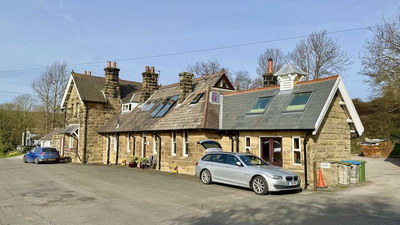
I begin my Robin Hood’s Bay walk at Station Car Park, making my way past Fylingdales Village Hall and the handsome old station buildings. The former Robin Hood’s Bay station opened in 1885 as part of the Scarborough and Whitby Railway, closing to passengers in March 1965. The stone buildings survive in good condition and are now in private use.

Grisport Unisex Adult Peaklander Hiking Boots
AD The Grisport Unisex Adult Peaklander Hiking Boots are crafted in Italy with a durable waxed leather upper, Spotex breathable lining, and a reliable Track-on rubber sole. Waterproof and weighing just 1120g, they offer comfort, resilience, and dependable performance on demanding trails.
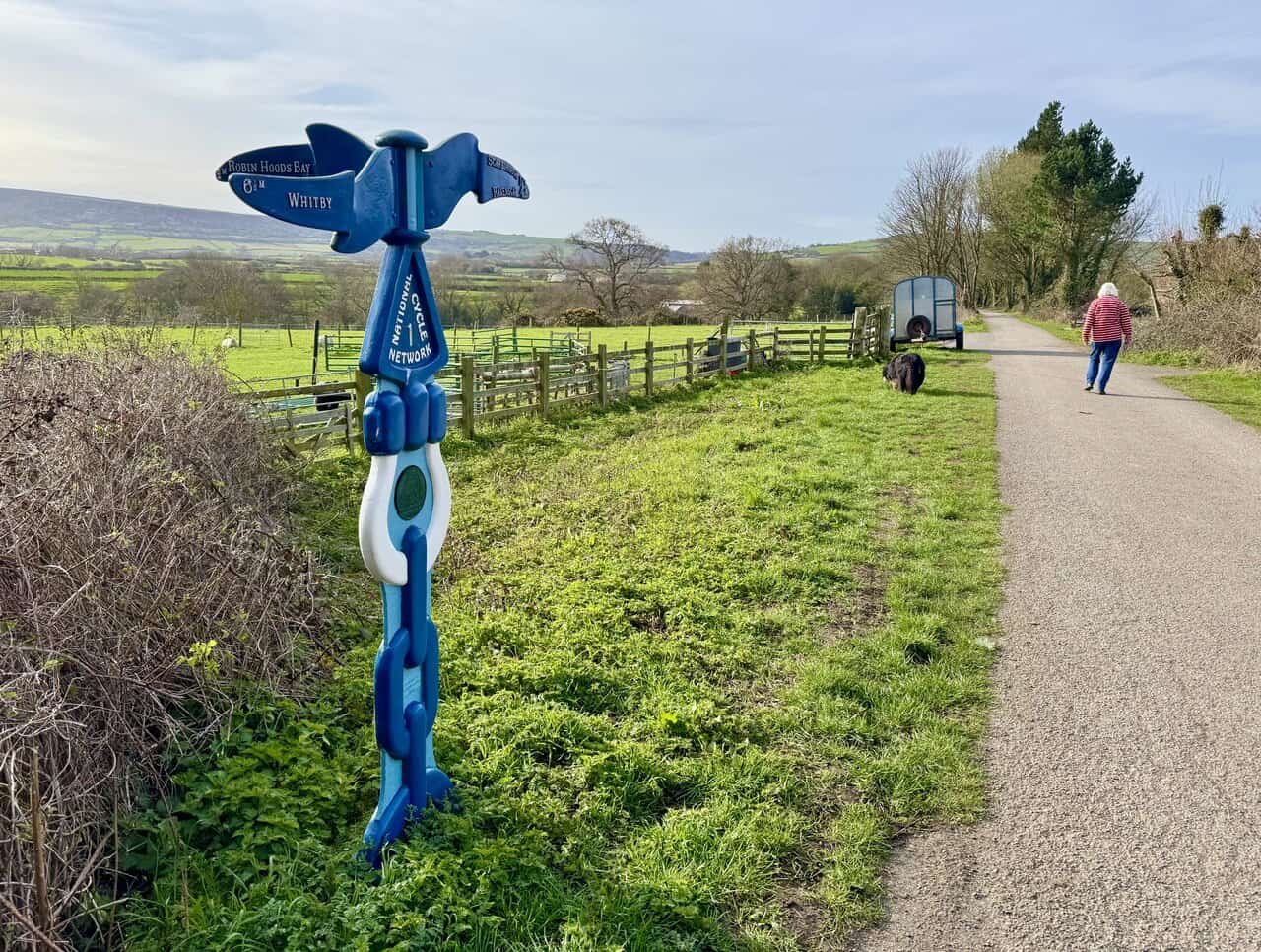
From Thorpe Lane, I join the Cinder Track and head south towards Ravenscar and Scarborough. A distinctive blue signpost for National Cycle Network Route 1 marks the way, its ornate design pointing towards Robin Hood’s Bay and Whitby in the opposite direction. The route follows the trackbed of the old Scarborough and Whitby Railway, now a popular path for walkers and cyclists.
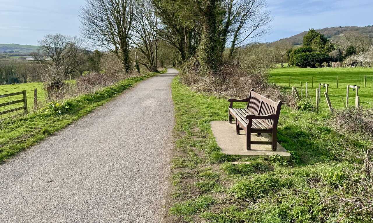
I continue heading south along the Cinder Track, following the well-surfaced path as it curves gently between open fields. A wooden bench beside the track offers a pleasant spot to pause and take in the views across the surrounding farmland. The path is lined with mature trees, and the route feels peaceful and easy underfoot.
Grisport Unisex Adult Peaklander Hiking Boots
AD The Grisport Unisex Adult Peaklander Hiking Boots are crafted in Italy with a durable waxed leather upper, Spotex breathable lining, and a reliable Track-on rubber sole. Waterproof and weighing just 1120g, they offer comfort, resilience, and dependable performance on demanding trails.
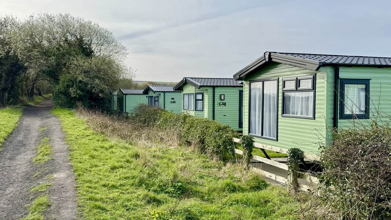
A little further on, I pass the caravans at Middlewood Farm Holiday Park, lined up neatly alongside the track. The Cinder Track runs right past the edge of the site, with the path narrowing slightly as it continues south through the trees. Middlewood Farm is a popular holiday park close to Robin Hood’s Bay, offering a convenient base for exploring the coast.
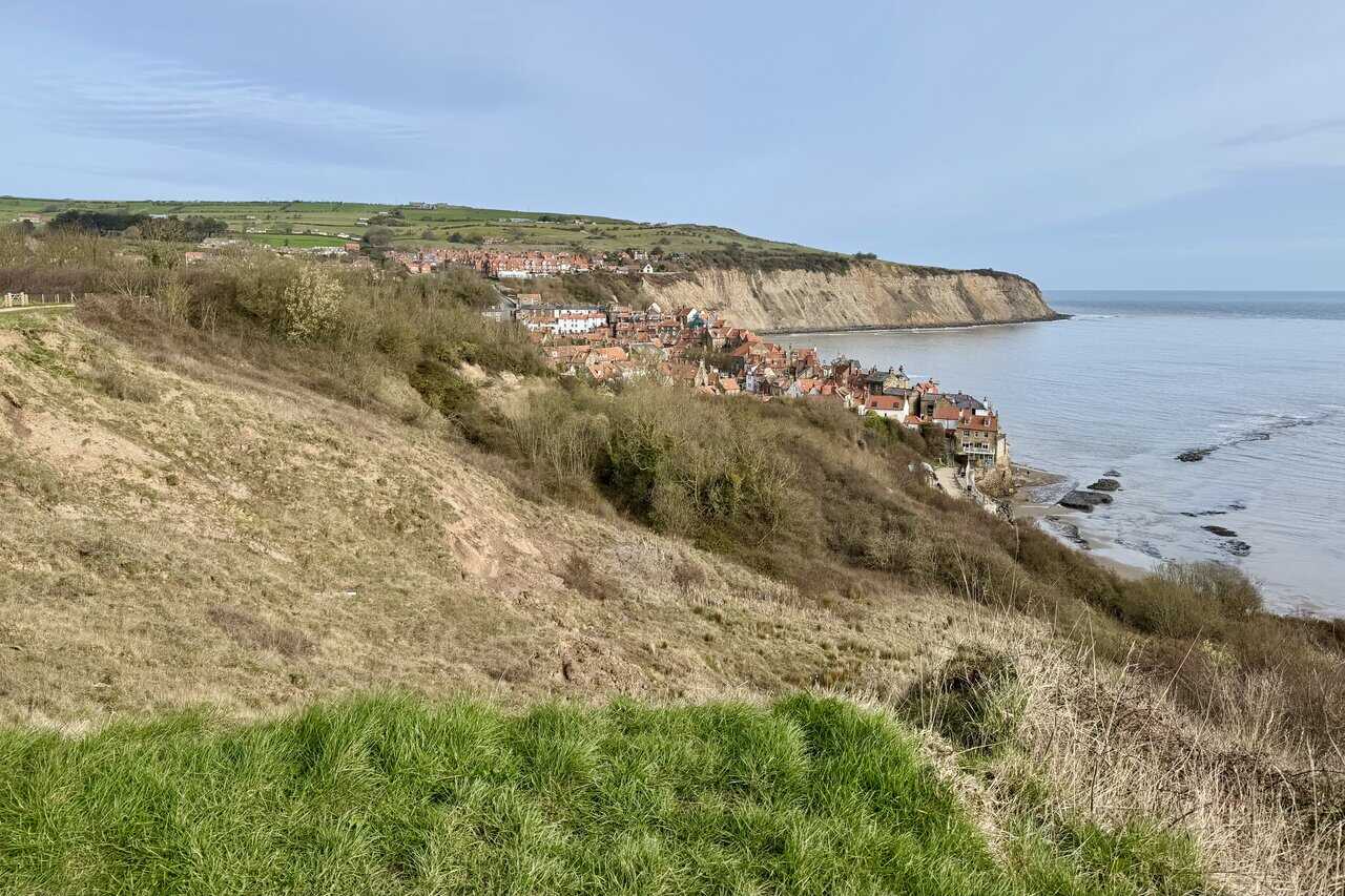
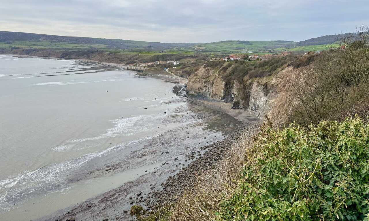
From the Cinder Track, I walk along Mark Lane and join the Cleveland Way, heading north along the clifftop path towards Robin Hood’s Bay. The view from here is one of the first real highlights of the Robin Hood’s Bay walk, with the red-roofed village tumbling down the hillside towards the sea. Tall cliffs rise beyond the old town, and the rocky shoreline stretches out below.

Fifty Walks Across the Beautiful North York Moors National Park
AD Discover 50 routes across the North York Moors, from short easy strolls to challenging high-level hikes. With OS maps, route descriptions, and local highlights, it also includes the legendary 40-mile Lyke Wake Walk, described in four accessible stages.
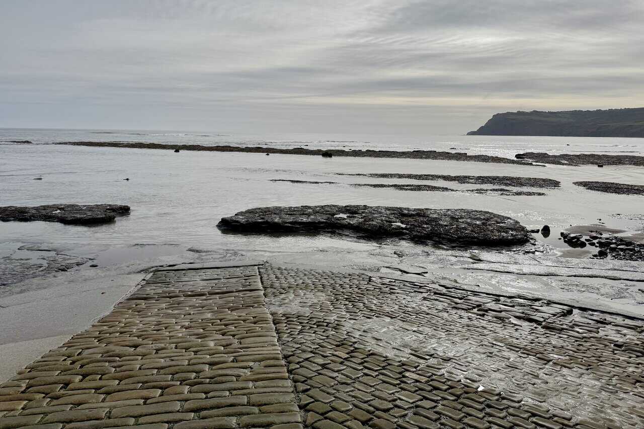
Descending into Robin Hood’s Bay, I make my way down to the old cobbled slipway at the bottom of the village. The tide is out, revealing broad rock platforms and dark slabs of stone stretching across the shore. In the distance, the headland at Ravenscar rises through the haze, adding a sense of scale to the coastline.
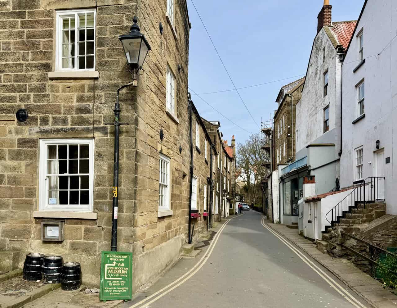
I follow New Road uphill through Robin Hood’s Bay, passing between the closely packed stone and whitewashed buildings that line the narrow street. A green sign on the corner points the way to the Robin Hood’s Bay Museum of Local History, housed in the old coroner’s room and mortuary. Old lamp posts and steep stone steps add to the character of this part of the village.
Fifty Walks Across the Beautiful North York Moors National Park
AD Discover 50 routes across the North York Moors, from short easy strolls to challenging high-level hikes. With OS maps, route descriptions, and local highlights, it also includes the legendary 40-mile Lyke Wake Walk, described in four accessible stages.
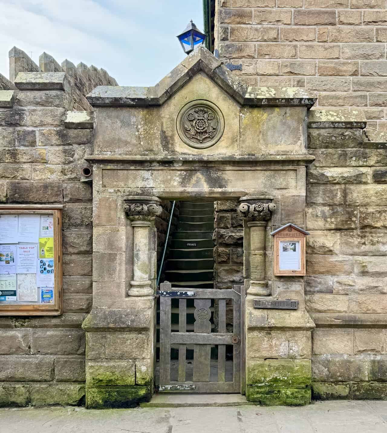
Following the road uphill, I pass Beckfield, the old police station in Robin Hood’s Bay. The handsome stone building with its green-trimmed gables was built in 1886 at a cost of £1,500, prompted by the influx of navvy labour working on the Scarborough and Whitby Railway. Saturday was pay day, and beer flowed freely, often leading to brawls on the beach between the workers and locals. Offenders were carted off to Whitby under a net and put in prison, so it was decided that Robin Hood’s Bay needed its own police house, complete with an office, two stoutly built cells and an exercise yard.
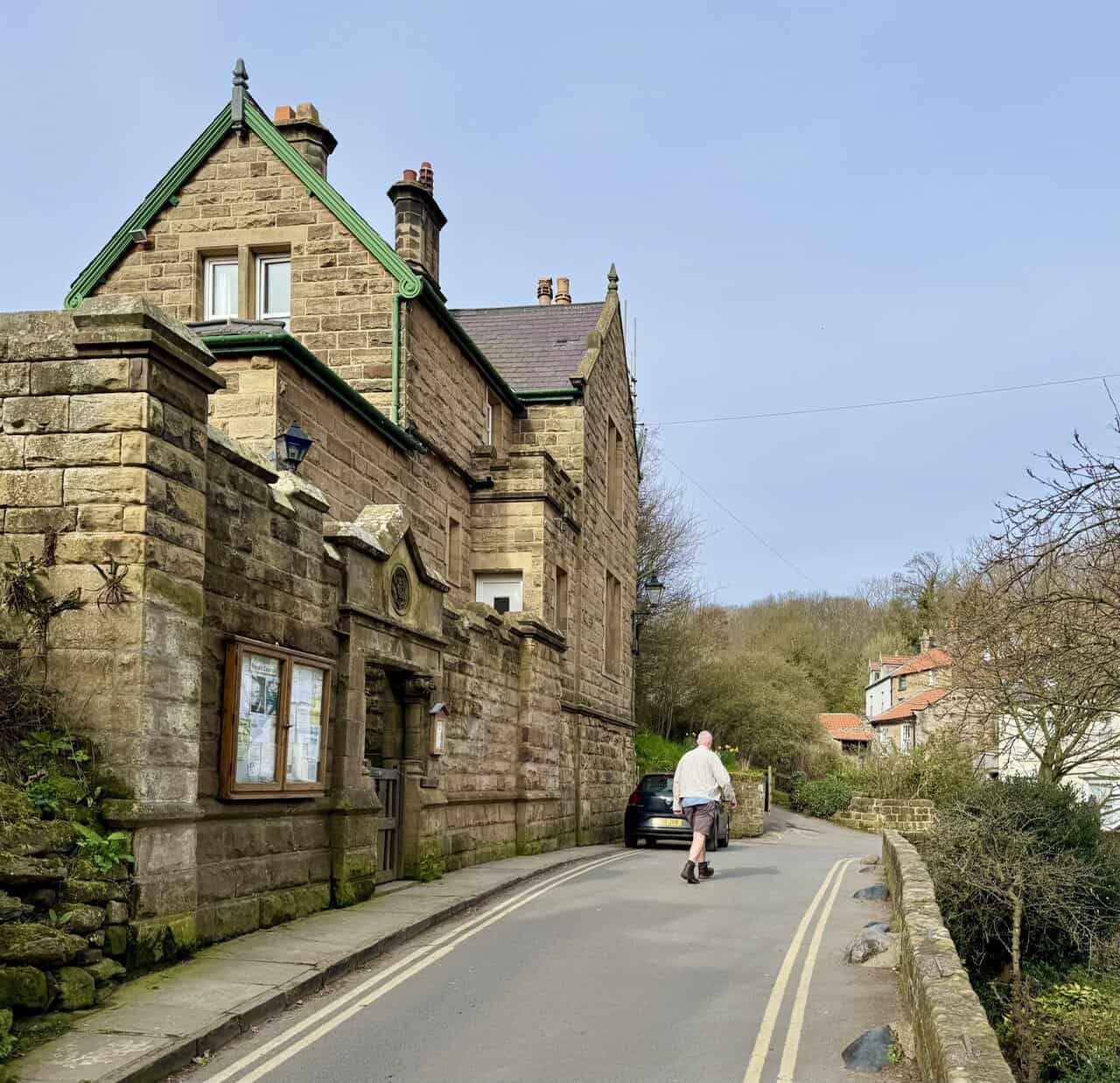
A closer look at the entrance reveals fine carved stonework, ornate columns and a circular rose motif above the doorway. According to local fisherman Oliver Storm, only two prisoners ever stayed overnight. After someone was killed during one of the beach struggles, the railway was completed in haste and the navvies moved on. The station became surplus to requirements and was sold in 1938 to the family who still own it, renaming it Beckfield. It now serves as a holiday cottage, and bookings can be made through Airbnb under the title “Quirky Police House”.

Osprey Hikelite Unisex Backpack for Comfortable and Lightweight Hiking
AD The Osprey Hikelite backpack combines lightweight design with practical features, including a breathable mesh back panel, soft webbing straps, and stretch mesh water bottle pockets. With zipped storage and an organiser compartment, it is ideal for day hikes and outdoor use.
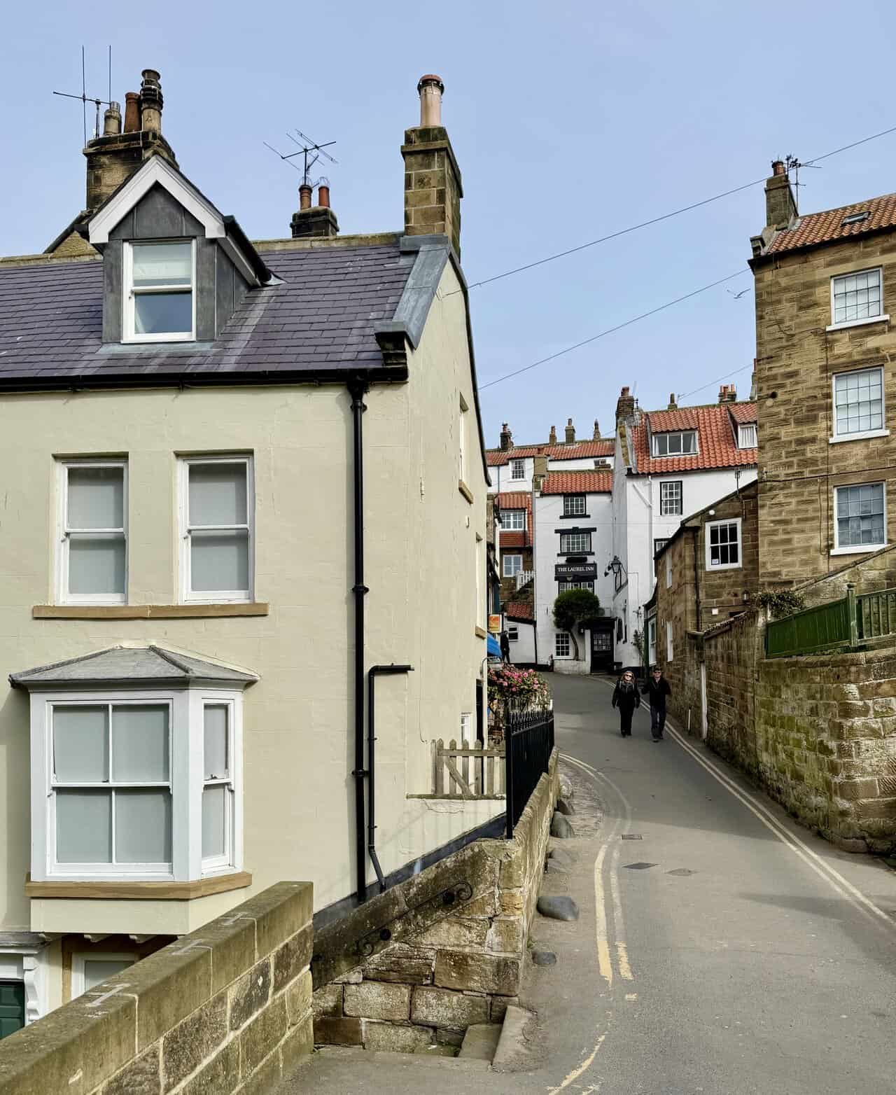
I continue uphill through the narrow streets of Robin Hood’s Bay, passing tightly packed cottages and traditional stone buildings. Ahead, the whitewashed frontage of The Laurel Inn comes into view, one of the village’s well-known pubs. The steep lanes and mix of painted and sandstone buildings give this part of the village plenty of character.
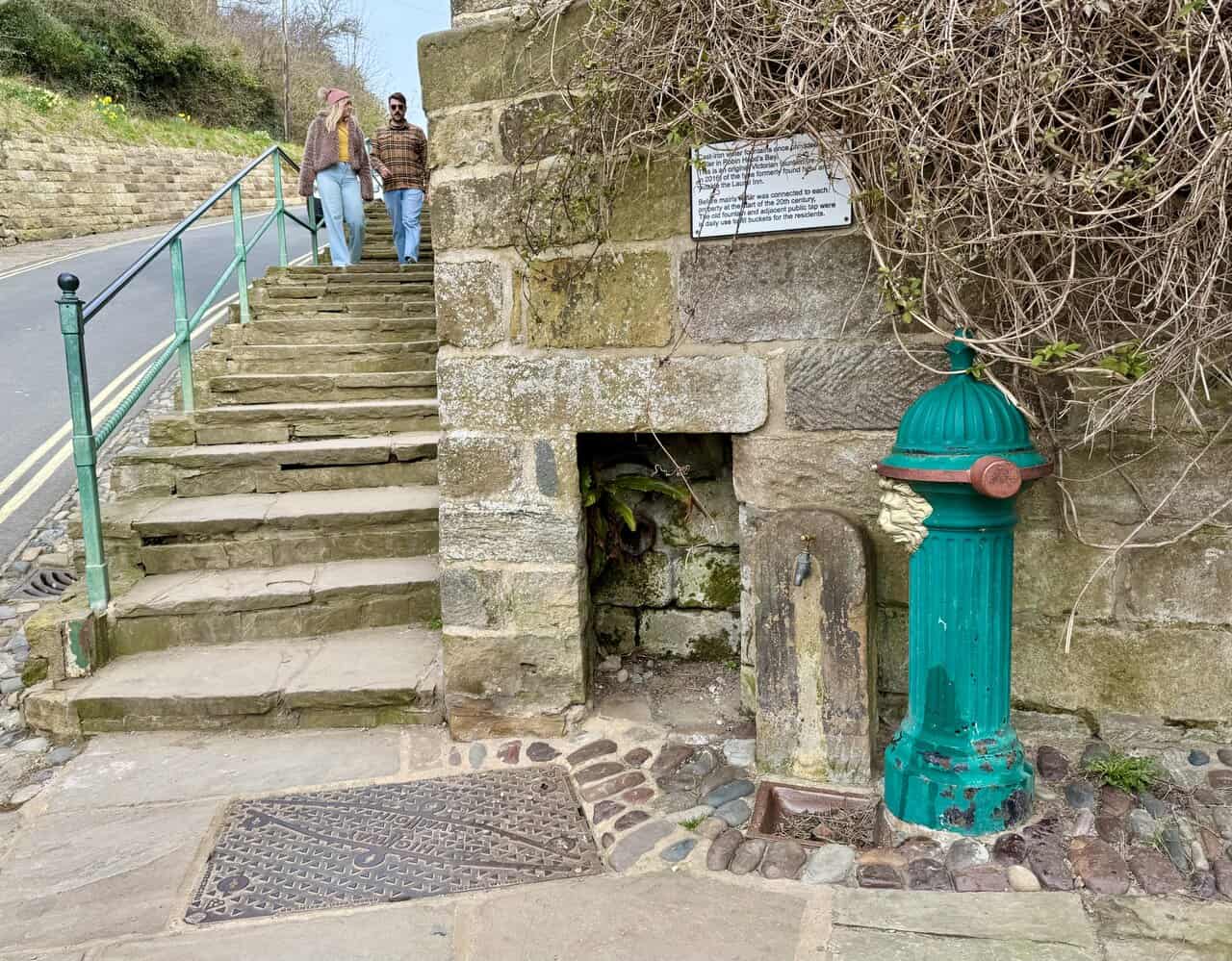
A little further up, I stop to look at a cast-iron water fountain set into the stonework beside a flight of steps. This is an original Victorian fountain, re-installed in 2016, of the type once found here and outside The Laurel Inn. Before mains water was connected to each property at the start of the 20th century, the old fountain and adjacent public tap were in daily use, with residents filling buckets for their households.
Osprey Hikelite Unisex Backpack for Comfortable and Lightweight Hiking
AD The Osprey Hikelite backpack combines lightweight design with practical features, including a breathable mesh back panel, soft webbing straps, and stretch mesh water bottle pockets. With zipped storage and an organiser compartment, it is ideal for day hikes and outdoor use.
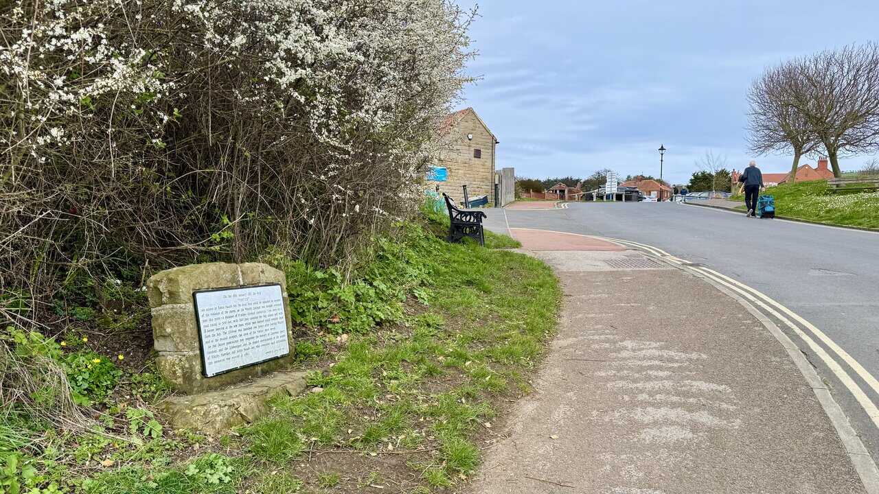
Almost at the top of the hill, I pass a memorial stone set on the grass verge. It tells the remarkable story of the brig Visiter, which ran ashore at Robin Hood’s Bay on 18th January 1881. With local boats unable to launch in the violent storm, the Whitby lifeboat was hauled overland past this very spot, a distance of six miles through seven-foot snowdrifts, with 200 men clearing the way and 18 horses pulling at the tow lines. Two hours after leaving Whitby, the lifeboat was launched and the crew of the Visiter were saved. The memorial was erected in 1981 to honour the bravery of Coxswain Henry Freeman and the determination of the people of Whitby, Hawsker and Robin Hood’s Bay.
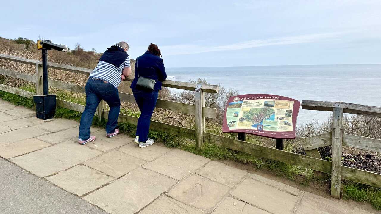
At the top of the hill, visitors lean against the wooden fence to take in the sea views, with a North York Moors National Park information board welcoming them to Robin Hood’s Bay. A telescope is also positioned here for a closer look along the coast. It’s a popular spot to pause and enjoy the outlook before continuing my Robin Hood’s Bay walk.

Peak Bagging Wainwrights with Routes to Complete All Fells
AD This comprehensive guide offers 45 circular routes linking all 214 Wainwright fells. With maps, GPX downloads, elevation profiles, and practical advice, it provides efficient yet inspiring ways to complete this classic Lake District challenge at your own pace.
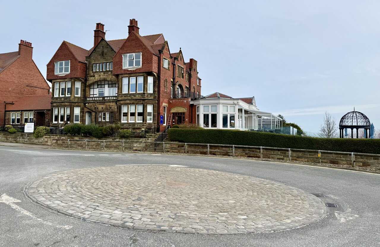
I reach the cobbled roundabout at the top of Robin Hood’s Bay, where the Victoria Hotel stands prominently overlooking the village and the sea. This grand Victorian hotel sits proudly at the clifftop, offering some of the best coastal views in North Yorkshire. With its striking stone and red-brick frontage, ornate gables and glass conservatory, it makes a fine landmark at this end of the village. An ornamental iron gazebo in the hotel grounds adds an elegant touch to the setting.
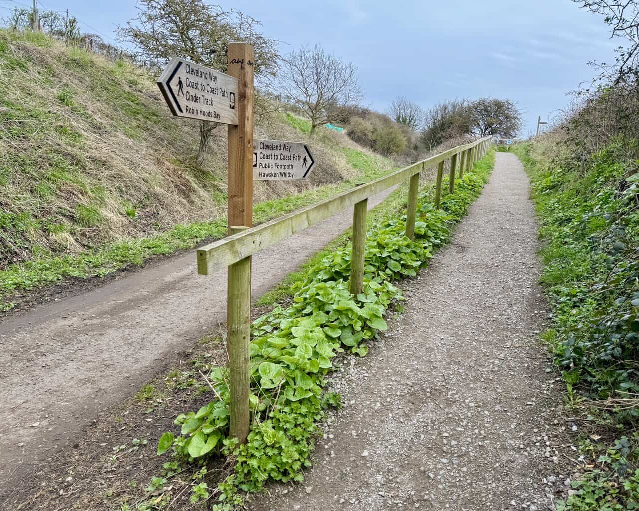
Leaving Robin Hood’s Bay, I follow the signs for the Cleveland Way and the Coast to Coast Path. Where the path splits into two, a wooden signpost marks the junction, with the Cinder Track to the left and the Cleveland Way, Coast to Coast Path and public footpath to Hawsker and Whitby to the right. I take the right-hand fork and head north along the clifftop path.
Peak Bagging Wainwrights with Routes to Complete All Fells
AD This comprehensive guide offers 45 circular routes linking all 214 Wainwright fells. With maps, GPX downloads, elevation profiles, and practical advice, it provides efficient yet inspiring ways to complete this classic Lake District challenge at your own pace.
After walking hardly any distance at all, I reach a wooden bench at a clifftop viewpoint looking back across Robin Hood’s Bay. The sweeping curve of the coastline stretches south towards Ravenscar, its broad headland rising in the distance. It’s a fine spot to sit and appreciate the scale of the bay before pressing on along the Cleveland Way.
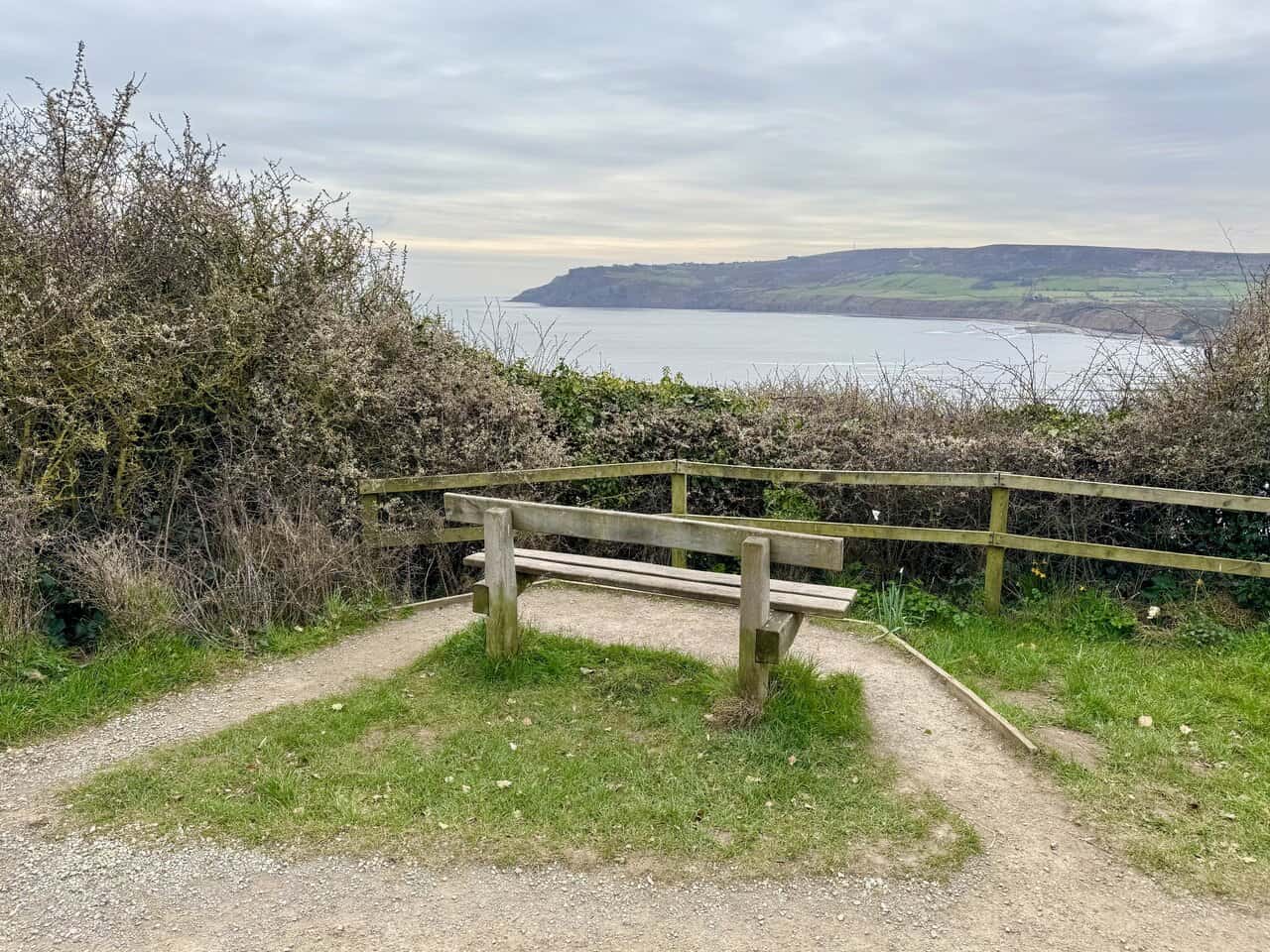
A little further along the Cleveland Way, I reach a spot marked on the Ordnance Survey map with the blue fan symbol for an exceptional viewpoint, and it doesn’t disappoint. It’s one of the best views on my Robin Hood’s Bay walk, looking back across the village nestled between steep, eroded cliffs and green farmland rising behind. Below, the tide washes over a rocky shore, and the full sweep of the bay curves away to the south.

Berghaus Hillmaster II GTX Men's High Rise Hiking Boots
AD The Berghaus Hillmaster II GTX men’s hiking boots feature a waterproof, breathable GORE-TEX membrane, a memory foam tongue and collar for a personalised fit, and a Vibram sole delivering exceptional grip, stability, and shock protection for confident performance on any terrain.
I head north along the Cleveland Way, following a grassy clifftop path between open fields and the sea. The Cleveland Way is one of England’s oldest National Trails, officially opened in 1969 as only the second national trail after the Pennine Way. It runs for 109 miles from the market town of Helmsley to Filey, tracing a roughly horseshoe-shaped route around the North York Moors National Park.
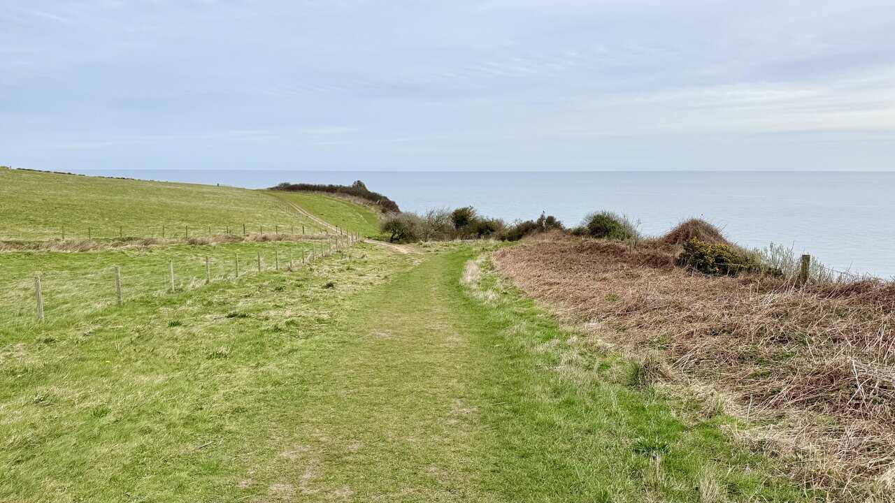
The Cleveland Way trail is a walk of two halves. The inland section crosses the heather moorland and escarpments of the North York Moors, while the coastal stretch follows the dramatic clifftops south from Saltburn-by-the-Sea, passing through Whitby, Robin Hood’s Bay and Scarborough on its way to Filey. Here, between Robin Hood’s Bay and Hawsker, the narrow, sandy trail climbs steadily through gorse and open grassland above the sea.
Berghaus Hillmaster II GTX Men's High Rise Hiking Boots
AD The Berghaus Hillmaster II GTX men’s hiking boots feature a waterproof, breathable GORE-TEX membrane, a memory foam tongue and collar for a personalised fit, and a Vibram sole delivering exceptional grip, stability, and shock protection for confident performance on any terrain.
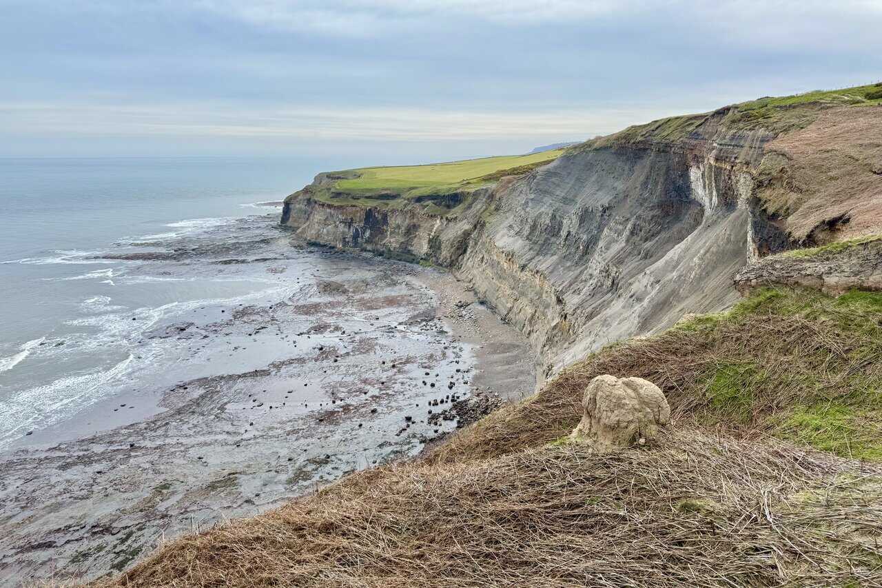
The Cleveland Way also forms part of the King Charles III England Coast Path along this stretch of coastline. Standing above Bulmer Steel and Ness Point, I’m rewarded with excellent views south, looking along the eroded cliffs towards Robin Hood’s Bay and Ravenscar beyond. The exposed rock layers and crumbling cliff face show the power of the sea along this coast, with boulders and rock platforms scattered across the shore far below.
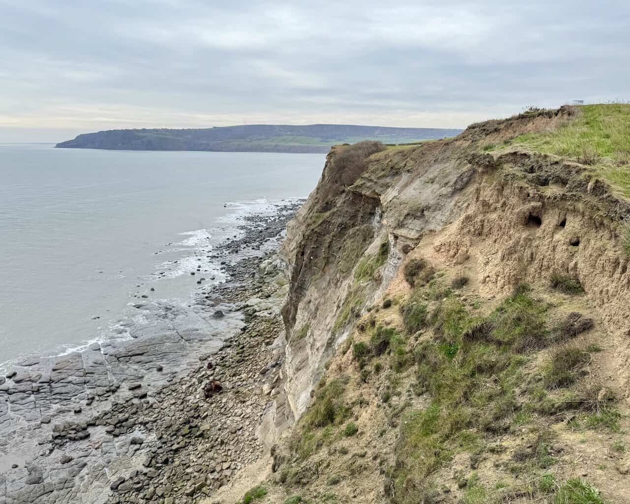
A little further along, above Craze Naze and the Cow and Calf, I look north-west along the coastline. The layered cliff face drops steeply to a broad expanse of rock platforms below, with the sea washing over boulders and slabs of stone. The cliffs stretch ahead in a series of jagged headlands, with green farmland running right to the edge above.

Kendal Mint Co Energy Gel with Citrus and Mint Flavour
AD Kendal Mint Co energy gels deliver 27g of fast-absorbing carbohydrates plus electrolytes and B vitamins for improved performance. Vegan, gluten free, and Informed Sport certified, these caffeine-free gels are refreshing, easy to digest, and ideal for running, cycling, and endurance.
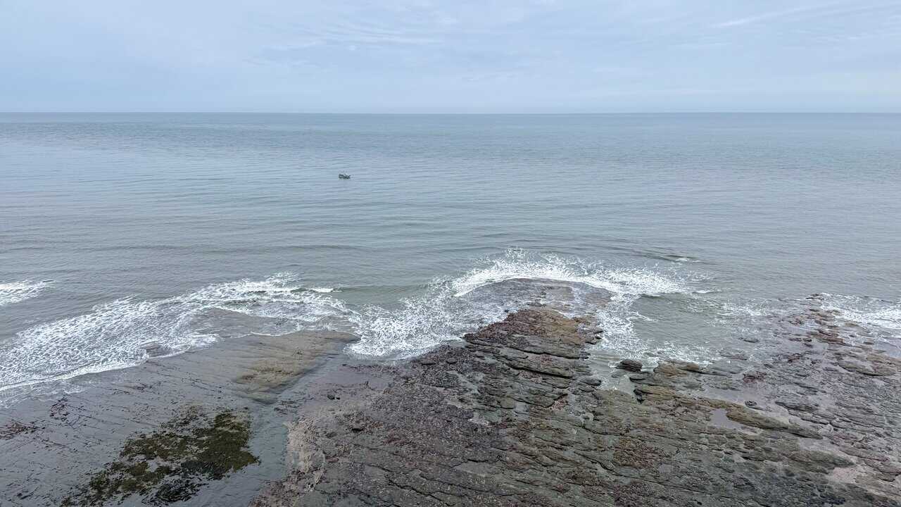
From the same spot, I look east out to sea. The water washes gently around broad rock platforms below the cliff edge, with seaweed and patches of colour visible across the stone. A small fishing boat sits quietly offshore on the still, grey-green water, and I’m really enjoying my Robin Hood’s Bay walk.
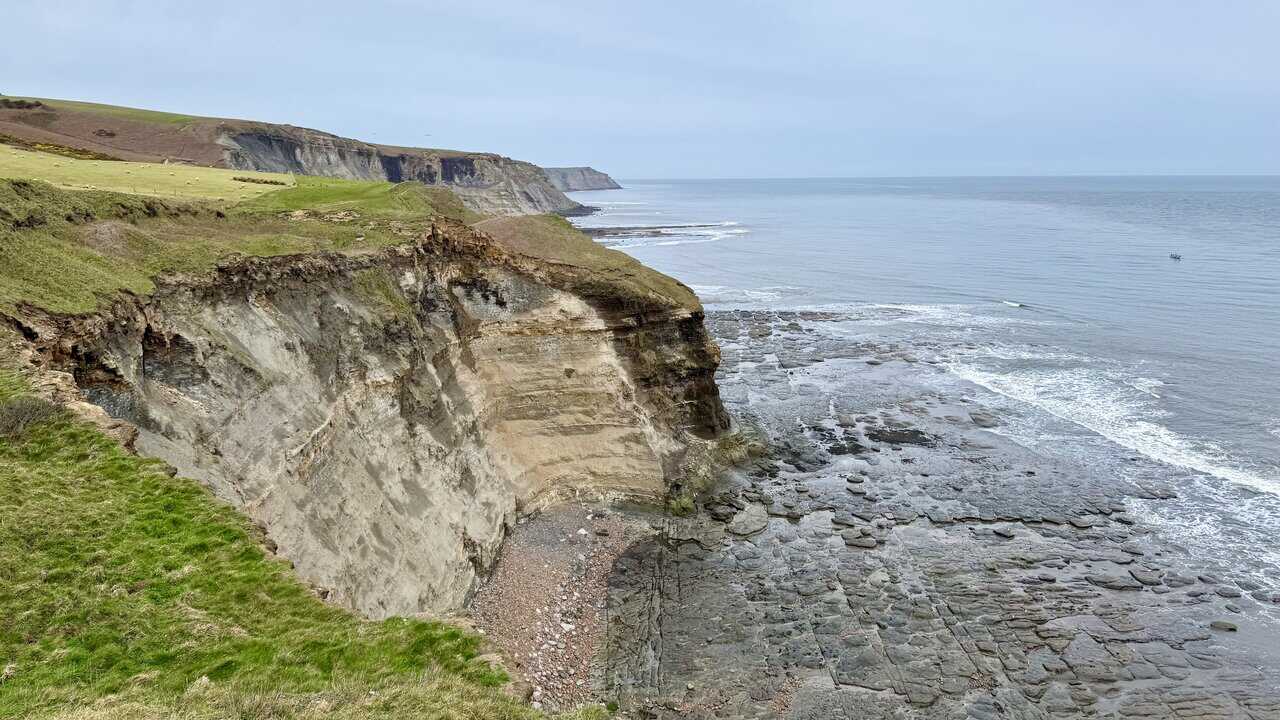
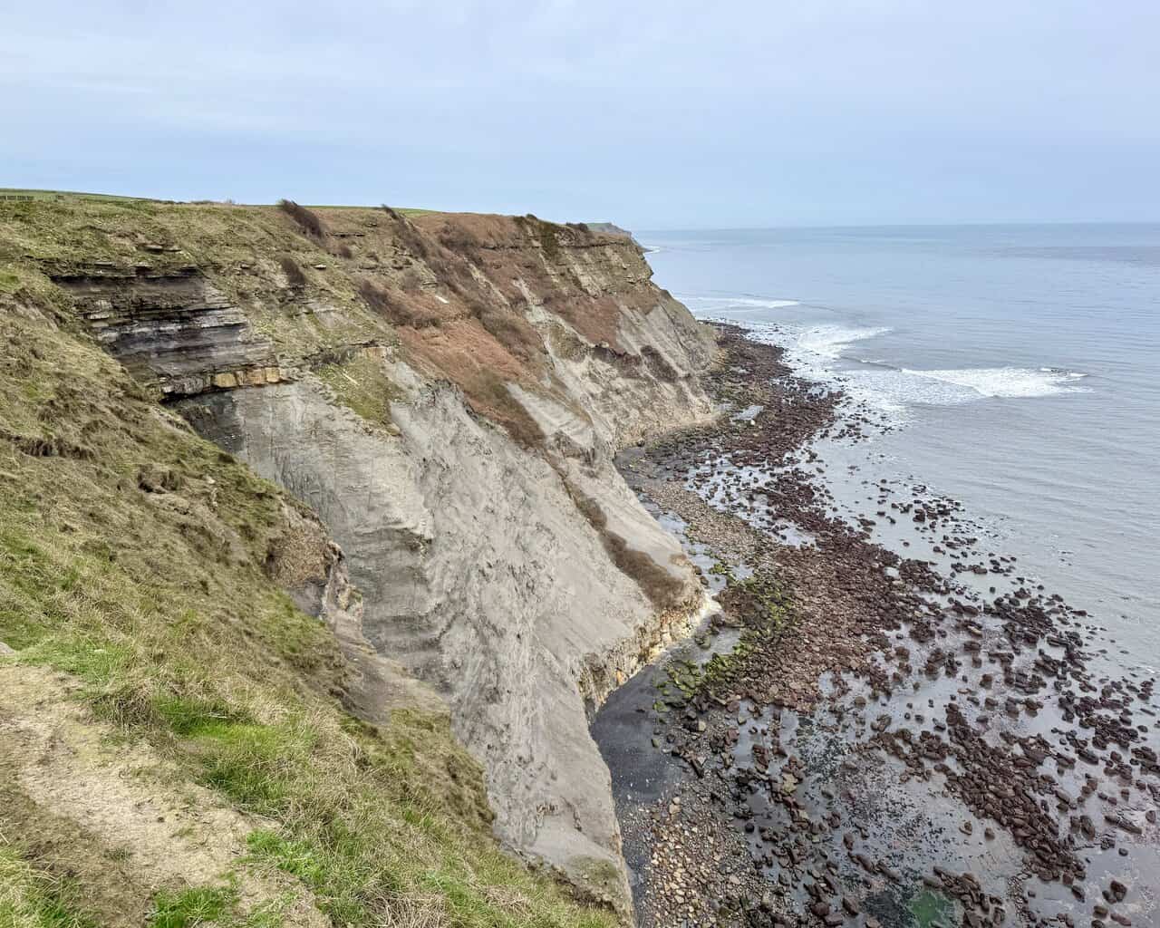
Further along the Cleveland Way, I’m treated to more excellent views from above Clock Case Nab, looking down towards the area marked on the OS map as Far Jetticks. The tall, layered cliffs reveal bands of rock in shades of grey, brown and ochre, with the sea washing across a wide, flat shore below. The coastline continues to impress as it stretches north towards Whitby.

Kendal Mint Co Energy Gel with Citrus and Mint Flavour
AD Kendal Mint Co energy gels deliver 27g of fast-absorbing carbohydrates plus electrolytes and B vitamins for improved performance. Vegan, gluten free, and Informed Sport certified, these caffeine-free gels are refreshing, easy to digest, and ideal for running, cycling, and endurance.
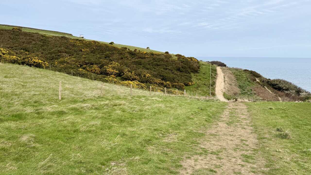
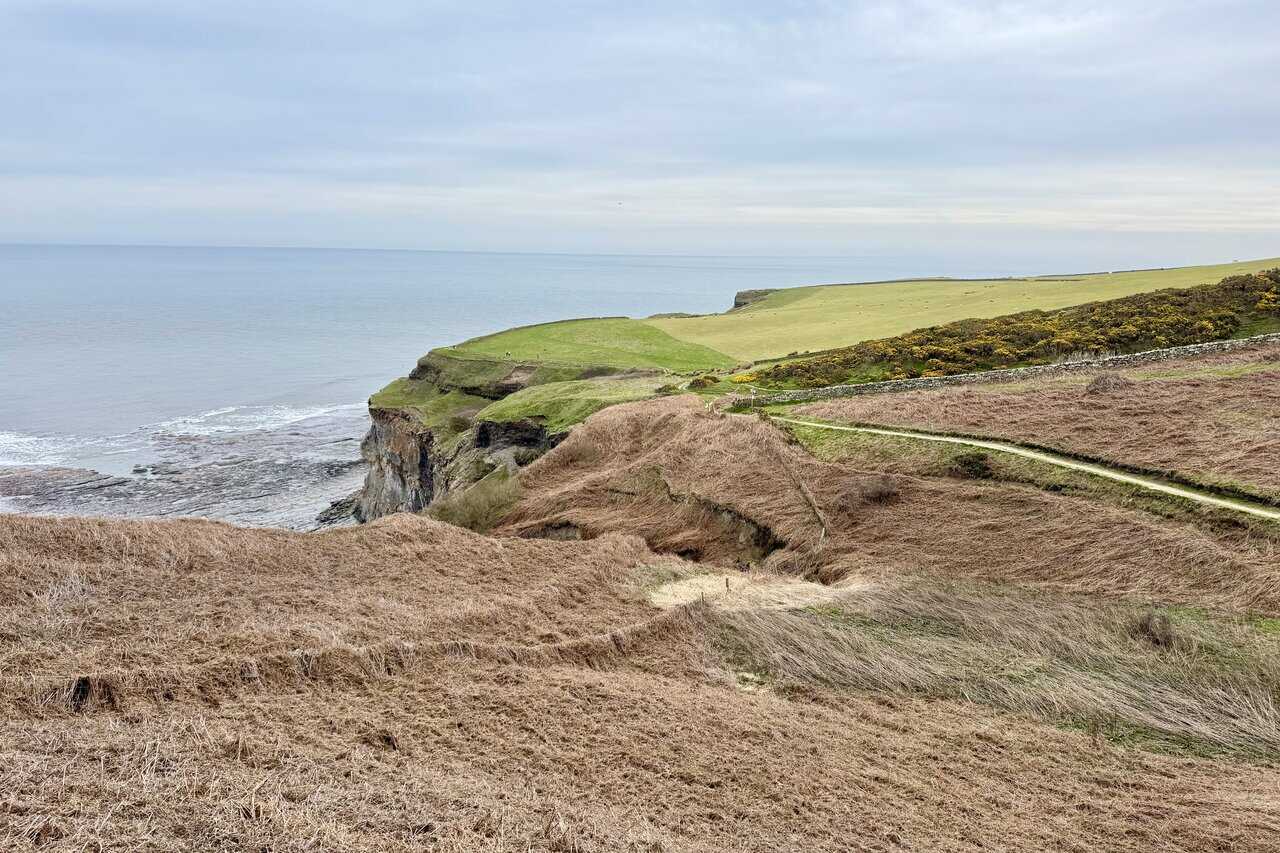
Continuing north, I look back towards Rain Dale, where the clifftop drops steeply into a deep, grassy hollow. The path winds ahead along the cliff edge, with a dry stone wall and patches of gorse running alongside. Beyond Rain Dale, green fields stretch out to the headland, with the sea calm and flat below.
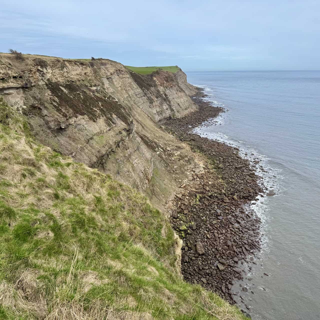
I reach the clifftop above Normanby Stye Batts and look back south towards Far Jetticks. The sheer cliff face reveals dramatic layers of grey and brown rock, with deep fissures carved out by the sea. Below, the tide retreats across a wide, boulder-strewn shore, and green fields run to the very edge of the crumbling cliffs ahead.

Thermos Stainless King Flask for Travel and Daily Adventures
AD The Thermos Stainless King 470ml flask keeps drinks hot for 18 hours or cold for 24. With durable stainless steel, vacuum insulation, a serving cup, and a leakproof design, it is perfect for commutes, journeys, and outdoor adventures.
From the same spot, I look north along the coastline. The cliffs here are heavily eroded, with exposed layers of rock tilting at steep angles and large sections of the cliff face fallen away. Dark boulders are scattered across the shore below, and the coast continues to stretch ahead towards Hawsker and Whitby.
Just below Northcliffe Holiday Park, I reach a signpost where the Coast to Coast Path branches off to the left towards Hawsker, one mile away. I carry straight on, following the Cleveland Way towards Whitby, three and a half miles ahead, with Robin Hood’s Bay now three miles behind me. The updated wooden signs here reflect the recent recognition of Alfred Wainwright’s Coast to Coast Walk, which was awarded National Trail status in 2022 and officially opened in March 2026. The 197-mile route runs from St Bees in Cumbria to Robin Hood’s Bay, crossing three national parks, and the new signage is part of a £5.6 million programme of improvements including better waymarking, upgraded surfaces and new paths along the route.
Thermos Stainless King Flask for Travel and Daily Adventures
AD The Thermos Stainless King 470ml flask keeps drinks hot for 18 hours or cold for 24. With durable stainless steel, vacuum insulation, a serving cup, and a leakproof design, it is perfect for commutes, journeys, and outdoor adventures.
A little further along, it’s time for me to branch off left from the Cleveland Way and make my way inland. Before I do, I take one final look north along the cliffs. The layered rock face drops steeply to a narrow, boulder-strewn shore, with the sea lapping gently at its edge. Green fields sit right at the cliff top, their edges slowly giving way to the constant erosion below.
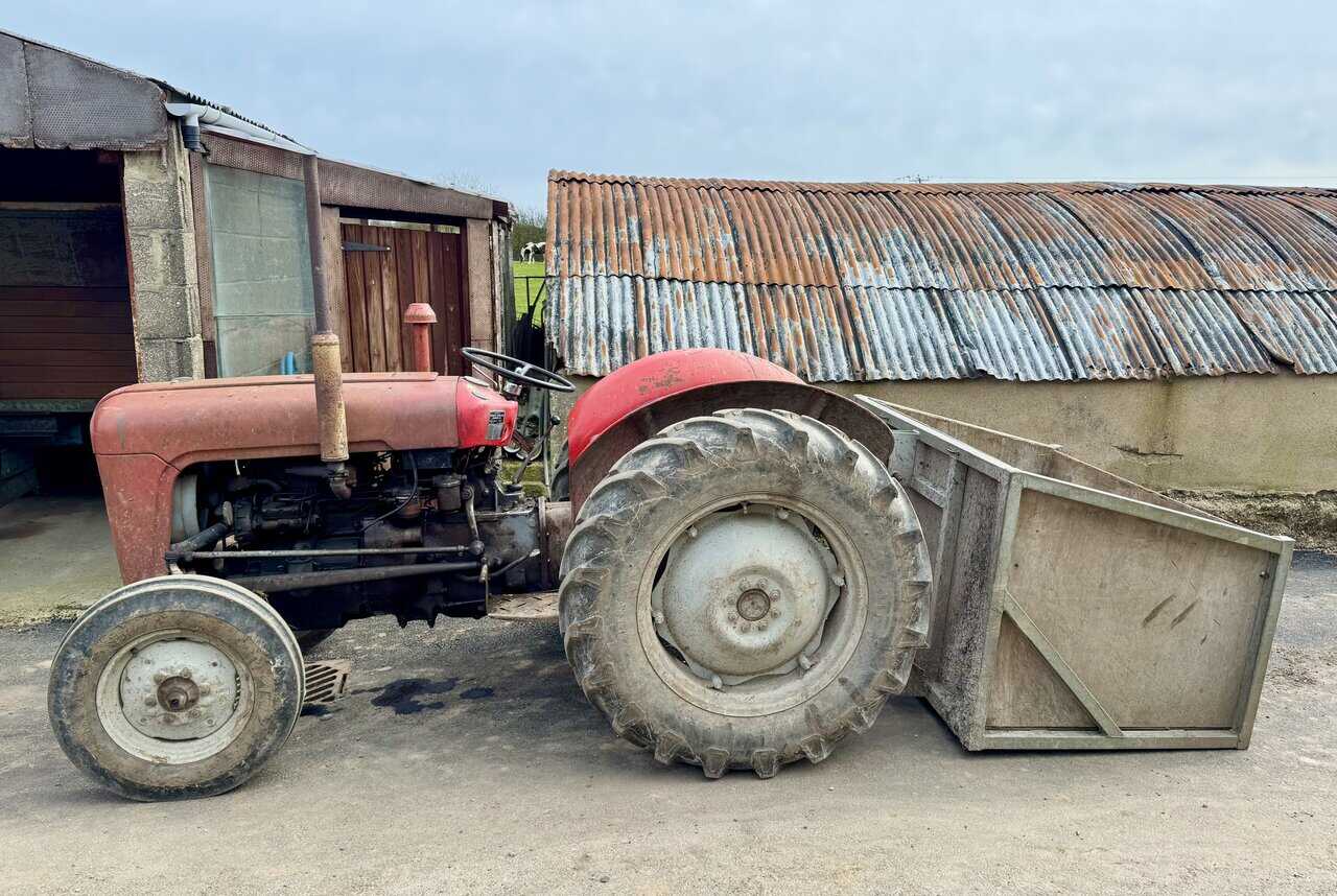
My route follows a broad stone track heading inland, crossing the Cinder Track and passing through a farm on the way to High Hawsker. In the farmyard, I can’t help but stop to admire this old red Massey Ferguson tractor, parked up beside a corrugated iron barn with a wooden transport box propped against its rear wheel. It looks like it’s seen plenty of hard work over the years.
Lake District High Level and Fell Walks with Thirty Routes
AD This pocket-sized guide presents 30 routes on the Lake District’s highest fells, including Scafell Pike, Helvellyn, and Blencathra. With OS maps, colour photographs, and practical notes, it offers circular walks from 4–15 miles graded by difficulty.
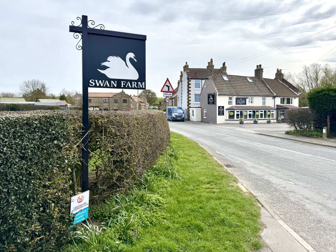
After the farm, I reach the B1447 at High Hawsker and turn left along the main road. The Swan Farm sign stands on the roadside, with The Hare and Hounds pub just ahead. It would be rude not to call in for a drink, so I do exactly that before continuing through the village.
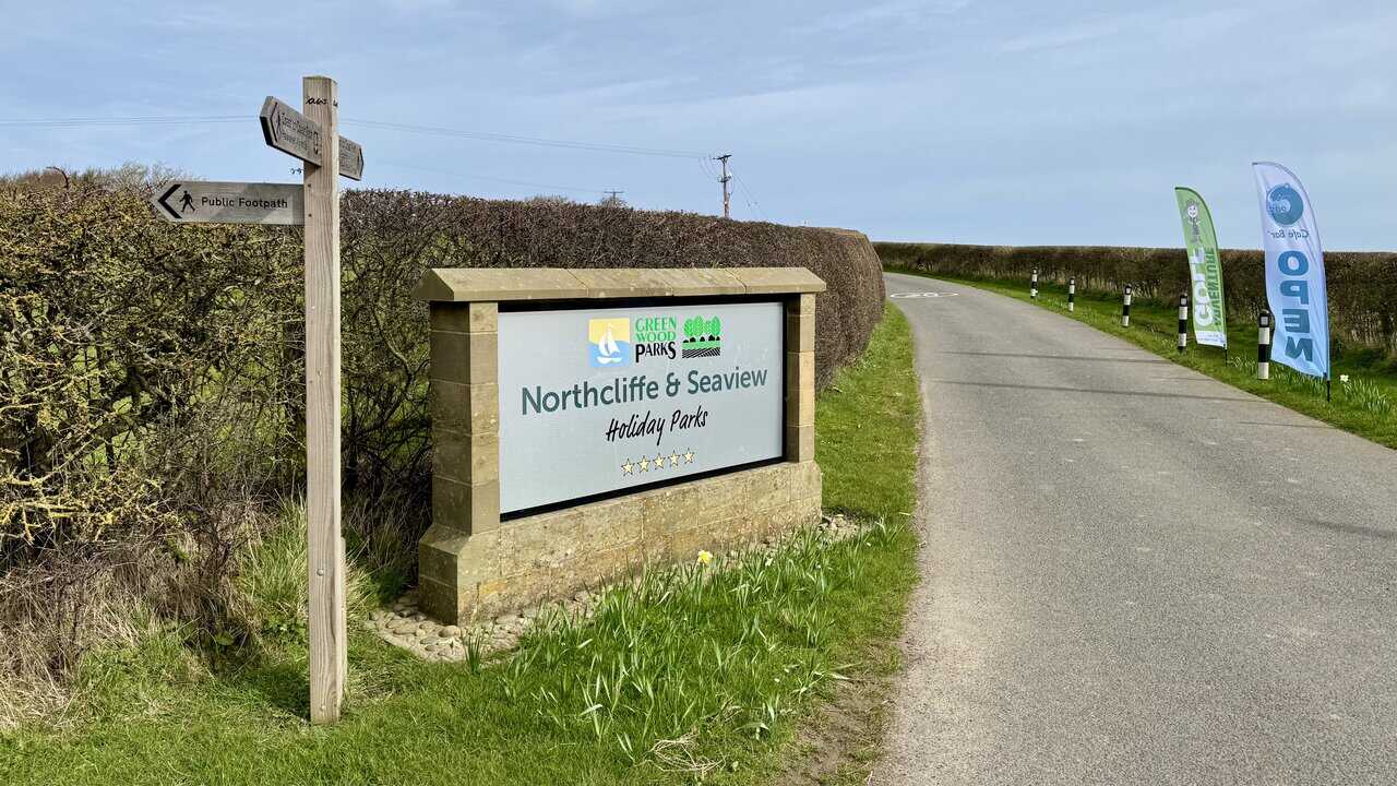
After leaving the village, I continue along the road before turning into Northcliffe and Seaview Holiday Parks, part of Green Wood Parks. A public footpath sign points the way, and the five-star park’s entrance road stretches ahead between neatly trimmed hedgerows. I passed the Cleveland Way signpost on the clifftop side of this park earlier in my Robin Hood’s Bay walk.
Lake District High Level and Fell Walks with Thirty Routes
AD This pocket-sized guide presents 30 routes on the Lake District’s highest fells, including Scafell Pike, Helvellyn, and Blencathra. With OS maps, colour photographs, and practical notes, it offers circular walks from 4–15 miles graded by difficulty.
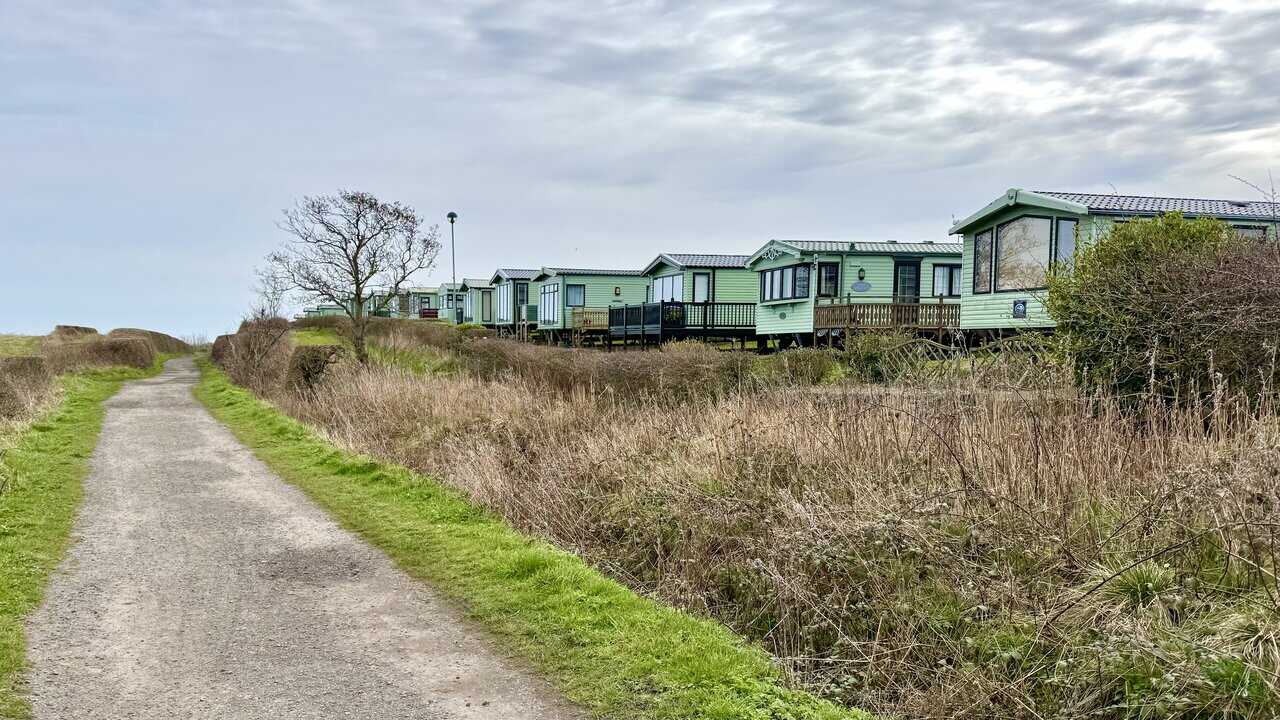
Between Seaview and Northcliffe, I turn right and rejoin the Cinder Track, now heading east back towards Robin Hood’s Bay. A row of green static caravans with wooden decking sits alongside the path, and the track stretches ahead as a straight, gravel path with grassy verges on either side. I’m now on the return leg of the walk.
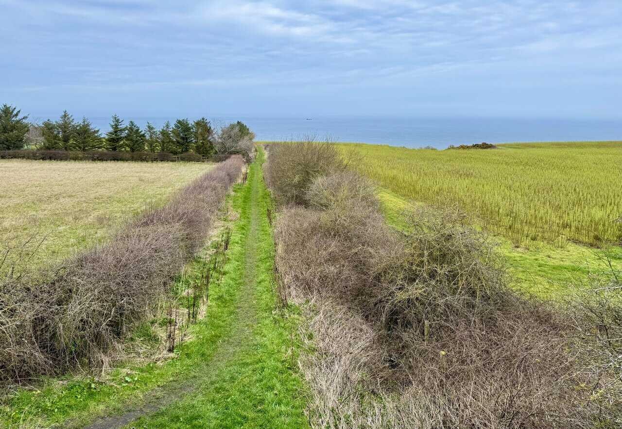
From the Cinder Track, I glance to the left and catch sight of a narrow green path running straight between hedgerows towards the sea. I don’t take it, but it’s a lovely view, with farmland on either side and the North Sea visible on the horizon. A row of conifers lines the edge of one field, and the path looks like it would make a fine walk of its own.
Super Sparrow Stainless Steel Insulated Water Bottle with Two Lids
AD The Super Sparrow stainless steel water bottle keeps drinks cold for 12 hours or hot for several. With a straw lid, bamboo cap, BPA-free construction, and durable 18/8 steel, it is ideal for sport, travel, work, and outdoor use.
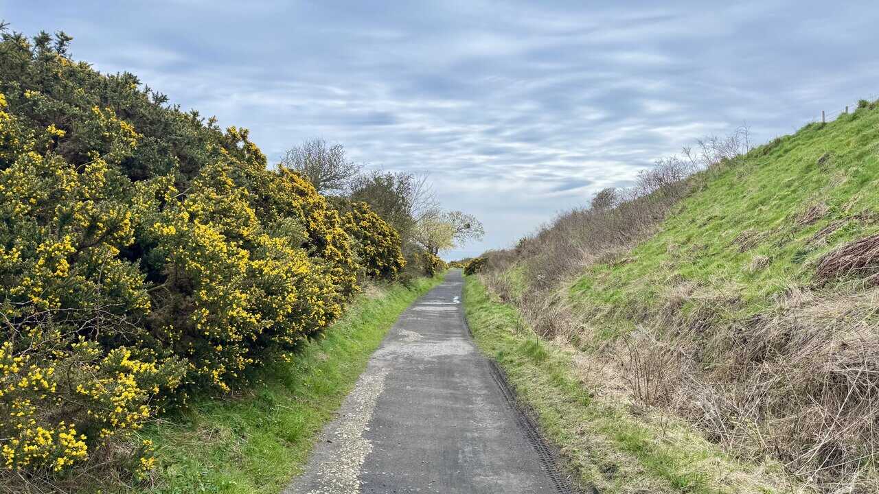
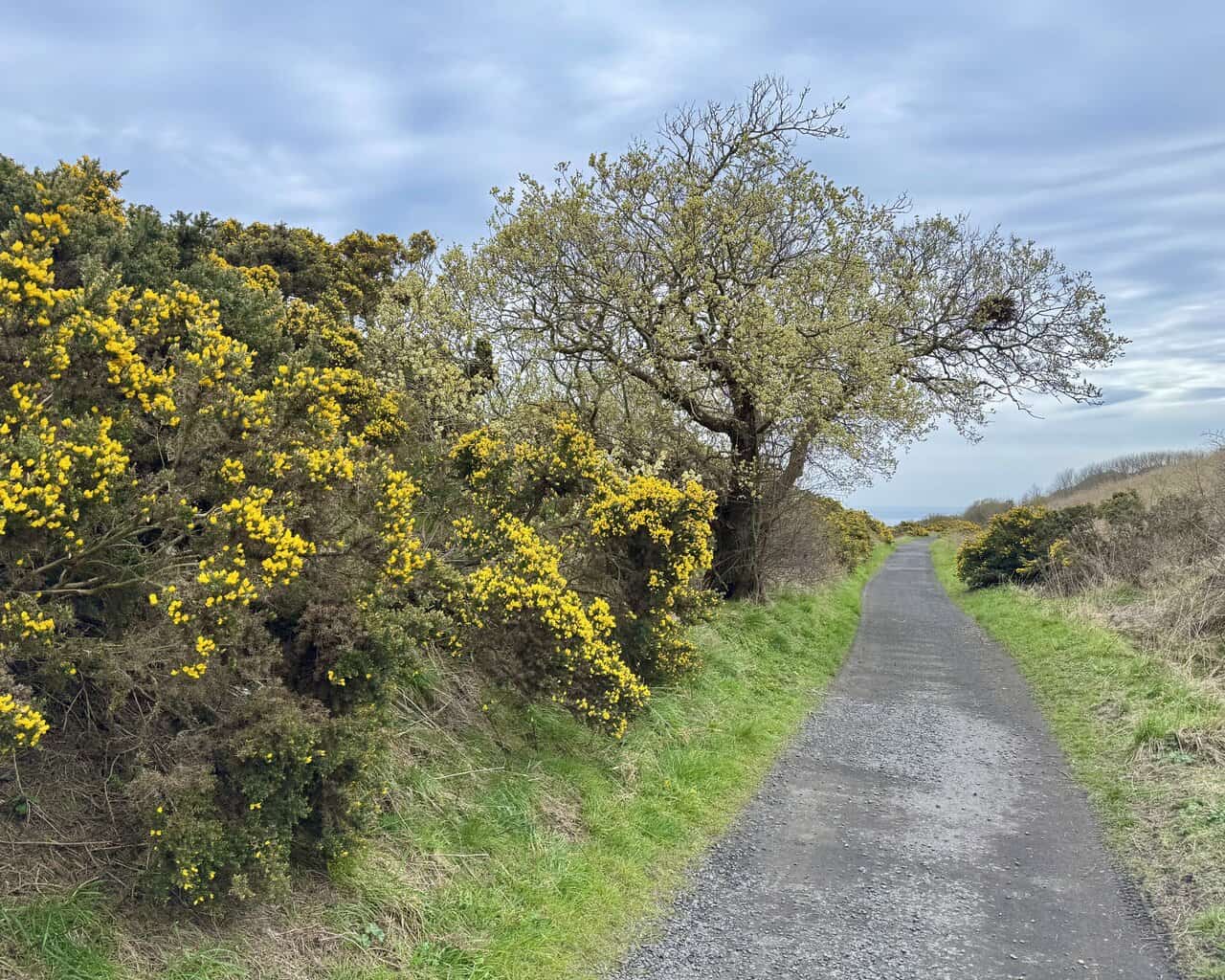
I continue along the Cinder Track towards Robin Hood’s Bay, with tall gorse bushes in full yellow flower lining the left-hand side of the path. The track runs 21 miles from Scarborough to Whitby, following the former trackbed of the Scarborough and Whitby Railway, which operated from 1885 until its closure in 1965 as part of the Beeching cuts. The ballast was made from cinders rather than crushed stone, which gives the route its name.
The Cinder Track now forms part of National Cycle Network Route 1 and is a popular route for walkers, cyclists and horse riders. The path here is well surfaced, running straight ahead through a cutting with grassy banks rising on either side. It’s a pleasant contrast to the clifftop walking earlier in the day, and I’m making good progress on the return leg towards Robin Hood’s Bay.
Super Sparrow Stainless Steel Insulated Water Bottle with Two Lids
AD The Super Sparrow stainless steel water bottle keeps drinks cold for 12 hours or hot for several. With a straw lid, bamboo cap, BPA-free construction, and durable 18/8 steel, it is ideal for sport, travel, work, and outdoor use.
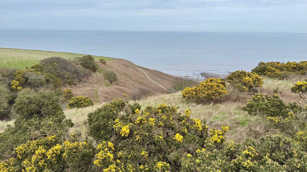
From the Cinder Track, I look down towards Rain Dale and the Cleveland Way, where I was walking earlier in my Robin Hood’s Bay walk. The narrow clifftop path is clearly visible, winding its way across the headland between thick clumps of yellow gorse. The sea stretches out beyond, calm and flat, with the rocky shore just visible below the cliffs.
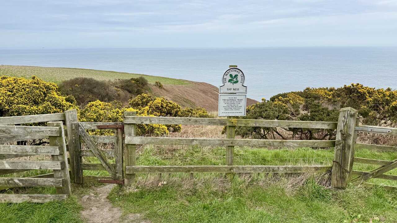
From roughly the same point, I spot a National Trust sign for Bay Ness, standing next to a wooden gate at the edge of the clifftop. The sign asks visitors to help care for the property, and beyond the gate, gorse-covered slopes drop away towards the sea. Bay Ness is marked on the OS map just west of Ness Point, and it’s good to see this stretch of coastline in National Trust care.
Mountain Warehouse Merino Womens Long Sleeve V Neck Top
AD This Mountain Warehouse Merino top combines warmth, comfort, and practicality. Made with high-quality wool, it is naturally antibacterial, lightweight, and easy to pack. Designed for outdoor activities, it keeps you fresh and warm, and comes with a two-year warranty.
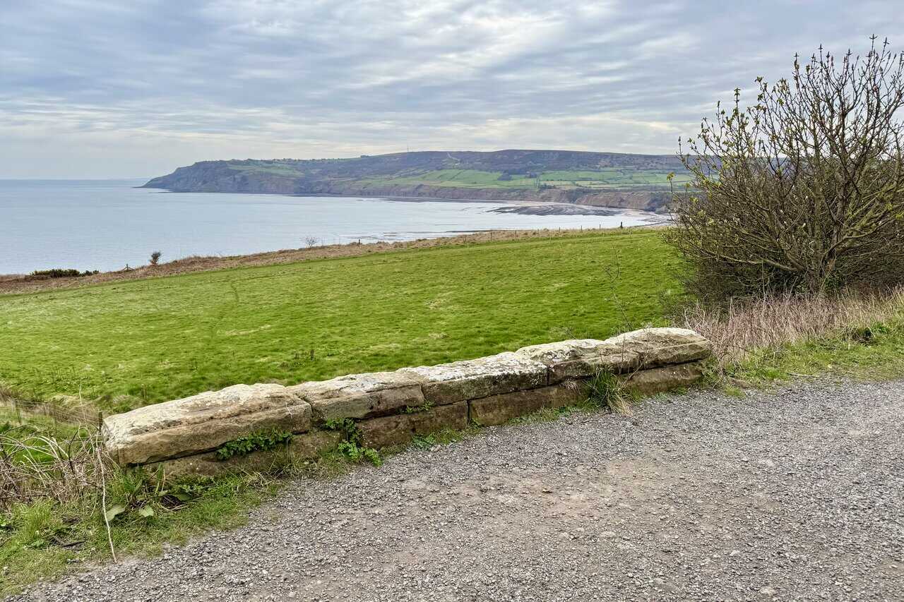
Shortly afterwards, the Cinder Track crosses a small single-arched stone bridge with a low parapet, and I’m treated to a wonderful view south across Robin Hood’s Bay towards Ravenscar. Green fields run right to the cliff edge, and the full sweep of the bay curves away in the distance. It’s one of the finest viewpoints on the Cinder Track, and a reminder of just how impressive this stretch of coastline is.
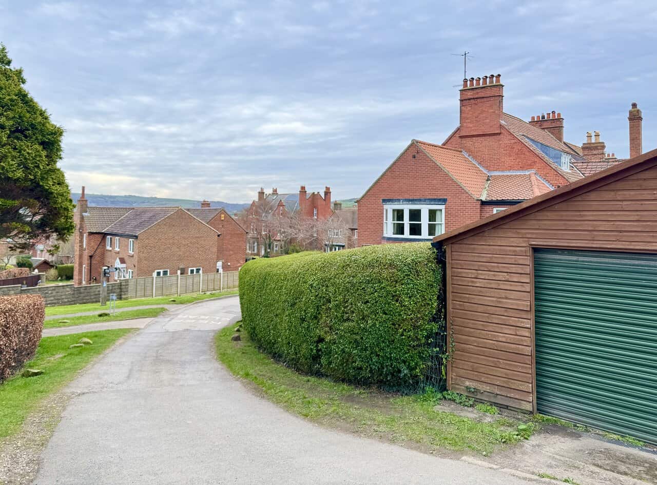
I’m almost at the end of my Robin Hood’s Bay walk now, as the Cinder Track brings me back into the village. The path curves between neat hedges and red-brick houses, with the moorland visible in the distance beyond the rooftops. It’s been a varied and rewarding walk, and I’m looking forward to the final stretch back to the car park.
Mountain Warehouse Merino Womens Long Sleeve V Neck Top
AD This Mountain Warehouse Merino top combines warmth, comfort, and practicality. Made with high-quality wool, it is naturally antibacterial, lightweight, and easy to pack. Designed for outdoor activities, it keeps you fresh and warm, and comes with a two-year warranty.
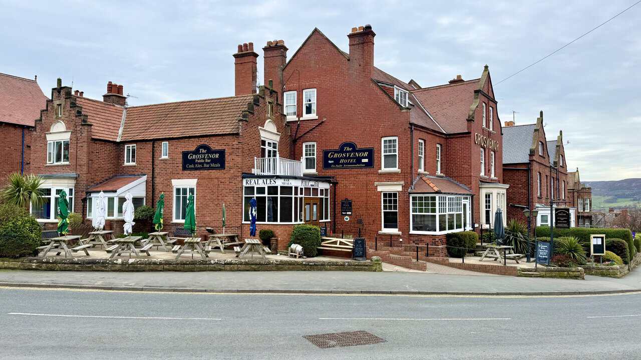
I finish my Robin Hood’s Bay walk back at Station Car Park, directly opposite The Grosvenor Hotel. This handsome red-brick building was purpose-built in the late 1890s and sits at the top of the village, offering cask ales, bar meals and en-suite accommodation. With its outdoor seating and prominent position on Station Road, it’s a popular stop for walkers completing the Cleveland Way or Coast to Coast Path.