Explore Why the Osmotherley Walk is a Favourite in the North York Moors
Begin your Osmotherley walk in the centre of Osmotherley, where there is a reasonable amount of roadside and other parking options. It is advisable to arrive fairly early to secure a spot. Start from the village green, heading north uphill along the road called N End. Although this road leads to Cod Beck Reservoir, you won’t be going that far. After about a quarter of a mile, turn left into Ruebury Lane. Look for the signpost indicating the Cleveland Way, Scarth Nick, and Lady Chapel.
Continue west uphill along Ruebury Lane, but be careful not to go too far. Turn right, following the footpath to Lady Chapel. Walk north through Chapel Wood, and at the end of the path, take the steps up into the grounds of Lady Chapel. Continue past the chapel and exit via the northern gate. Optionally, before you leave, if you have time, why not consider a short detour along the Rosary Path, which circles the chapel and returns you to the grounds.

After leaving the chapel grounds, go through a gate and turn right, following the signs for the Cleveland Way. Descend and pass through another gate, turning right again. Follow the Cleveland Way north and uphill for about a mile, initially through woods and then along the eastern edge of the woods. You’ll pass a radio and TV transmission station on your left before reaching a gate where the path emerges onto Scarth Wood Moor.
Here, you’ll find a delightful stone-paved path crossing the moor, offering fantastic views of the surrounding countryside. As you reach the end of the path, look for a signpost indicating the Cleveland Way. Instead of continuing on the Cleveland Way, bend to the right and follow the public bridleway, which will lead you down to a minor road. Walk south along this quiet road to the footbridge and ford known as Sheepwash.
Cross the bridge and head up the stone track, guiding you south along High Lane. This route skirts the eastern edge of a large forested area above Cod Beck Reservoir. After just over a mile, the stone track will lead you to a minor road. Continue south along this road to the luxury guest house known as Chequers. Shortly after passing Chequers, look out for a path to your right, signposted as a public footpath. This grassy path heads south-west, initially across moorland and then downhill to reach a farm in Oak Dale.

Turn right and walk past the farm, rejoining the Cleveland Way. Continue along the Cleveland Way, crossing a bridge in the wooded valley, then head uphill north-west along a concrete track leading to a minor road. Notice a house with an amazing garden at this road. Turn left, then immediately turn right, signposted Cleveland Way and Osmotherley. Walk uphill along this track for a few minutes, then take a left again, following the Cleveland Way signs.
The route will guide you along a track towards Whitehouse Farm. Before reaching the farm, veer off to the right, again following the Cleveland Way signs. Descend into a small, narrow, wooded valley, cross a footbridge, and climb out of the valley up some steep steps. At the top, emerge from the woods and follow a stone-paved path across the fields. This path will lead you back into the village of Osmotherley.
This lovely walk in the North York Moors is just under 7 miles (11 kilometres) in length. You’re sure to enjoy this scenic and rewarding Osmotherley walk.
Osmotherley Walk: Maps and Tools
Visit either the OS Maps website or the Outdooractive website to view this walking route in greater detail. Both platforms offer a range of features, including the ability to print the route, download it to your device, and export the route as a GPX file. You can also watch a 3D fly-over and share the route on social media.
Osmotherley Walk: Distance, Duration, Statistics
Distance: 6¾ miles
Distance: 11 kilometres
Duration: 3½ hours
Ascent: 1094 feet
Ascent: 333 metres
Type: Circular walk

Recommended Ordnance Survey Map
The best map to use on this walk is the Ordnance Survey map of the North York Moors Western Area, reference OS Explorer OL26, scale 1:25,000. It clearly displays footpaths, rights of way, open access land and vegetation on the ground, making it ideal for walking, running and hiking. The map can be purchased from Amazon in either a standard, paper version or a weatherproof, laminated version, as shown below.
About Osmotherley
Osmotherley is a charming village and civil parish in the Hambleton Hills of North Yorkshire, situated six miles (9.6 kilometres) north-east of Northallerton. Nestled at the western edge of the North York Moors National Park, Osmotherley lies on the route of the 110-mile (177-kilometre) Cleveland Way, one of the National Trails established by Natural England.
The Origin of Osmotherley’s Name
The name Osmotherley likely originates from a Viking named ‘Asmund’ or a Saxon named ‘Osmund’, with ‘ley’ meaning a clearing. In the Domesday Book, it was recorded as Asmundrelac, later evolving into Osmundeslay and Osmonderlay.
A local legend tells a poignant story of the village’s name. It is said that Oswald or Osmund’s mother ventured out in winter to gather firewood. When she did not return, her son went to find her and discovered her lying in the snow, either dead or dying from the cold. Unable to carry her back, he lay beside her and died as well. Thus, the village was named Osmotherley, meaning ‘Oswald’s mother lies here’.
Governance in Osmotherley
Historically part of the North Riding of Yorkshire, Osmotherley has been administered as part of North Yorkshire since 1972. The village falls under the jurisdiction of North Yorkshire Police, established by the Local Government Act 1972.
The electoral ward named Osmotherley extends north and south from the village, with a population of 1764 according to the 2011 census. It is part of the Richmond and Northallerton parliamentary constituency.
Amenities in Osmotherley
Osmotherley boasts several amenities, including Osmotherley Primary School, founded in 1857, with the current building dating from 1878. The school, located on School Lane, has fewer than 50 pupils.
The village features three public houses within a 55-yard (50-metre) radius: the Queen Catherine, the Three Tuns, and the Golden Lion. Other amenities include a newsagent, a Youth Hostel, and an antique shop. In 2019, the Osmotherley Fish and Chip Shop was awarded the best fish and chip shop in Northern England at the England Business Awards.
The Barter Table on the village green, a five-legged structure with a stone slab top, is a Grade II listed site where goods were historically exchanged.
Religion in Osmotherley
St Peter’s Church, built on an Anglo-Saxon site, contains Norman elements and was largely rebuilt in 1892 by architect C. Hodgson Fowler. The church is Grade II listed.
John Wesley, the founder of Methodism, preached at the Barter Table several times, starting in 1745. A Methodist Chapel was erected in 1754.
The Osmotherley Friends Meeting House, a traditional stone building from either 1690 or 1723, holds monthly meetings and is thought to have been visited by George Fox, a prominent Quaker, in the late 17th century.
The Geography of the Osmotherley Walk
Osmotherley is located on the edge of the North York Moors, the largest expanse of upland moorland in Great Britain. To the north lies Cod Beck Reservoir, named after Cod Beck, a tributary of the River Swale. The beck derives its name from the Celtic word ‘Coed’, meaning wood. Nearby is Sheepwash, a picturesque location along the beck.
The village is near the western end of the Lyke Wake Walk, with the official starting point at a stone marker. About 1½ miles (2.4 kilometres) from Osmotherley, near the A19, are the ruins of Mount Grace Priory, a Carthusian religious house founded around 1396.
Osmotherley Walk: My Photos
I make my way west up Ruebury Lane soon after starting my Osmotherley walk. The lane, and indeed much of this walk, follows the Cleveland Way National Trail.

As I gain a bit of height, reaching around 200 metres, I peek over the hedge. The views to the west over the Vale of Mowbray are stunning. It is a beautiful start to the walk, hinting at what is to come with the fantastic weather.

A toposcope greets me immediately after turning right off Ruebury Lane onto the path leading to the Lady Chapel. Facing south-west, it offers views across the Vale of Mowbray towards Masham and Ripon, extending to the eastern Yorkshire Dales’ hills and mountains. A gap in the trees enhances the view. The toposcope lists places like York to the south, Northallerton to the west, and Durham to the north. Erected in 1980, it honours Walter Evans, a founder member of the Osmotherley Civic Society.

Along the picturesque path from Ruebury Lane to Lady Chapel, winding through serene Chapel Wood, I encounter a series of poignant wooden crosses. The path features nine crosses, with the remaining six situated within the Lady Chapel grounds, totalling fifteen. Each wooden cross is accompanied by a carved wooden plaque with inscriptions reflecting significant moments in Jesus’ journey. These inscriptions commemorate Jesus’ trials and sacrifices, offering profound reflections on his suffering, compassion, and ultimate triumph:
- I. Jesus is condemned to death.
- II. Jesus receives his cross.
- III. Jesus falls the first time.
- IV. Jesus meets his mother.
- V. Simon of Cyrene helps Jesus to carry his cross.
- VI. Veronica wipes the face of Jesus.
- VII. Jesus falls again.
- VIII. Jesus consoles the women of Jerusalem.
- IX. Jesus falls the third time under his cross.
- X. Jesus is stripped of his garments.
- XI. Jesus is nailed to the cross.
- XII. Jesus dies on the cross.
- XIII. Jesus is taken down from the cross.
- XIV. Jesus is buried.
- XV. Jesus rises from the dead.


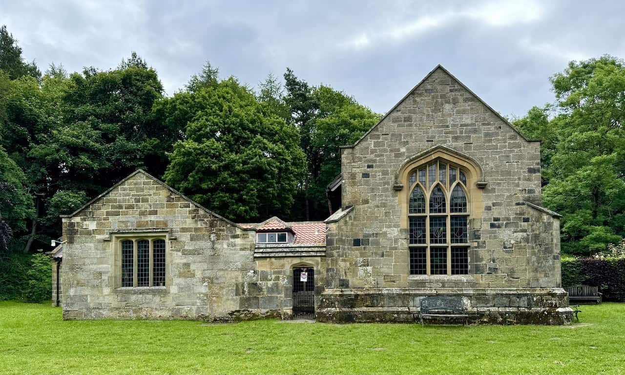
The path to Lady Chapel passes a large sycamore tree on the left and then ascends steps to the southern entrance of the chapel grounds. The visit to Lady Chapel is a highlight of this Osmotherley walk.

The Lady Chapel on the Osmotherley Walk
The full name of the Lady Chapel is the Shrine of Our Lady of Mount Grace. Its origins are unknown. In 1366, the manor of Bordelby, where Mount Grace Priory and the Lady Chapel stand, was conveyed to trustees for a religious purpose. John Ingelby, in 1397, received a licence for a chapel and Mass celebration in the manor house. In 1398, Thomas de Holand, possibly an original trustee, founded a Carthusian Monastery, naming it the House of Mount Grace of Ingleby. The Lady Chapel’s foundations suggest monks built it around the same time as the monastery cells, likely for their use before the 15th century’s end. Evidence indicates Hugh lived as a hermit in the chapel, with the first resident priest mentioned in 1522.

In 1515, former Franciscan Thomas Parkinson entered the hermitage at the Lady Chapel, supported by Katharine of Aragon. He remained until Mount Grace Priory’s dissolution in 1539. The priory’s lands and buildings then passed to Sir James Strangways. John Wilson, the last prior, received a pension and the Lady Chapel in perpetuity. Despite being in ruins, the chapel continued to attract pilgrims, alarming York authorities. On 7 September 1614, sixteen people were arrested for praying there.

Pilgrims included sisters of the Institute of the Blessed Virgin Mary, praying for their foundress Mary Ward. Jesuit priest John Robinson visited during the Civil War period. In 1665, Lady Juliana Walmsley founded a Franciscan Friary in Osmotherley to support pilgrims. Despite calls for repairs, by 1745, John Wesley reported the chapel was in poor condition.
After Catholic emancipation in 1829, secular clergy served the chapel. In 1916, Flora Morrish discovered the chapel and contacted landowner Sir Thomas Hugh Bell, who protected the ruins and restored a cottage. Then in 1942, priests Peter Storey and Michael O’Sullivan found the ruins, leading to increased interest.

In 1953, the National Trust took over the priory ruins. The Lady Chapel site was purchased by Lord Eldon and Ralph Scrope, who established a trust for its rebuilding. Restoration plans were approved in 1956, and by 1959, work began using stone from Rosedale Abbey. The chapel was re-dedicated in 1961.

Today, the chapel features a 17th-century statue of the Madonna and Child and a wooden crucifix symbolising liberation. The stained glass windows bear the arms of Queen Katharine of Aragon and the Scrope and Eldon families. Inscriptions and mason’s marks from penal times are visible. In 1965, Franciscan Friars returned, building facilities for pilgrims. In 1994, Benedictine monks from Ampleforth Abbey took over, and in 2013, the Diocese of Middlesbrough assumed responsibility. The Lady Chapel continues to be a place of pilgrimage and devotion.

Lovely benches are placed around the quaint chapel grounds, perfect for a rest and perhaps a bite to eat or a coffee. It’s a moment to enjoy this peaceful place.

Behind the bench in this photo, a gap in the trees offers panoramic views. I am fortunate to visit on a clear day and can see the unmistakable shape of Penhill in the Yorkshire Dales, almost 30 miles (48 kilometres) away, roughly between Leyburn and Aysgarth.

Before leaving the chapel grounds from the northern exit, there is a path to the right called the Rosary Path. It’s worth taking a walk here. The path leads uphill and circles around the elevated eastern side of the chapel. It’s a short path that brings you back to the chapel.

The Rosary Path is a lovely little detour during this Osmotherley walk. It winds through the woods behind the chapel with plenty of benches to sit on and enjoy.

At the top of the Rosary Path, there is a bench right on the edge of the woods.

The bench offers views across the open fields towards the Cleveland Hills.
As I walk along the Rosary Path near Lady Chapel, I encounter several plaques marking significant moments for reflection and meditation. Each plaque provides a focal point for pilgrims to pause, pray, and meditate on these profound events, enriching their spiritual journey along the path. These plaques detail the Mysteries of the Rosary, with titles indicating their sequence within each set, such as ‘First Mysteries of the Rosary’, ‘Second Mysteries of the Rosary’, and so on. The Rosary is a cherished form of prayer in the Catholic tradition, with the Mysteries grouped into four sets, each containing five events:
- Joyful Mysteries: the Annunciation, the Visitation, the Nativity, the Presentation in the Temple, and the Finding of Jesus in the Temple.
- Sorrowful Mysteries: the Agony in the Garden, the Scourging at the Pillar, the Crowning with Thorns, the Carrying of the Cross, and the Crucifixion.
- Glorious Mysteries: the Resurrection, the Ascension, the Descent of the Holy Spirit, the Assumption of Mary, and the Coronation of Mary.
- Luminous Mysteries: the Baptism of Jesus in the Jordan, the Wedding Feast at Cana, the Proclamation of the Kingdom, the Transfiguration, and the Institution of the Eucharist.

Immediately after leaving the chapel from the northern exit, some steps lead down to the Cleveland Way signpost. Here, I am greeted with remarkable views west across the Vale of Mowbray, seeing in the distance the hills and mountains in the Swaledale, Wensleydale, and Wharfedale regions of the Yorkshire Dales. My Osmotherley walk is living up to my expectations.

Continuing downhill from the Lady Chapel exit, there’s another signpost at a junction. To the left is the route of Alfred Wainwright’s Coast to Coast walk. But my route follows the track to the right, continuing along the Cleveland Way uphill through the woods.

The route through the woods climbs fairly steeply uphill, arriving at a viewpoint at the top. The views are amazing. Over the tops of the trees in the foreground, I can see the expansive landscape of the Vale of Mowbray, its patchwork of fields stretching out towards the horizon. In the distance, the hills and mountains of the Swaledale and Wensleydale regions of the Yorkshire Dales are visible.

From the same viewpoint, the views are equally stunning, looking north-west across the lowlands of the Tees Valley.

The Cleveland Way passes by the radio and TV transmission station.

This is the triangulation pillar just north of the transmission station, standing at 299 metres. The pillar is in a field just off the main path, to the east of Arncliffe Wood. Directly behind is the tree-covered Whorl Hill near Faceby. On the horizon, on the left side of the picture, is the distinctive cone-shaped Roseberry Topping.

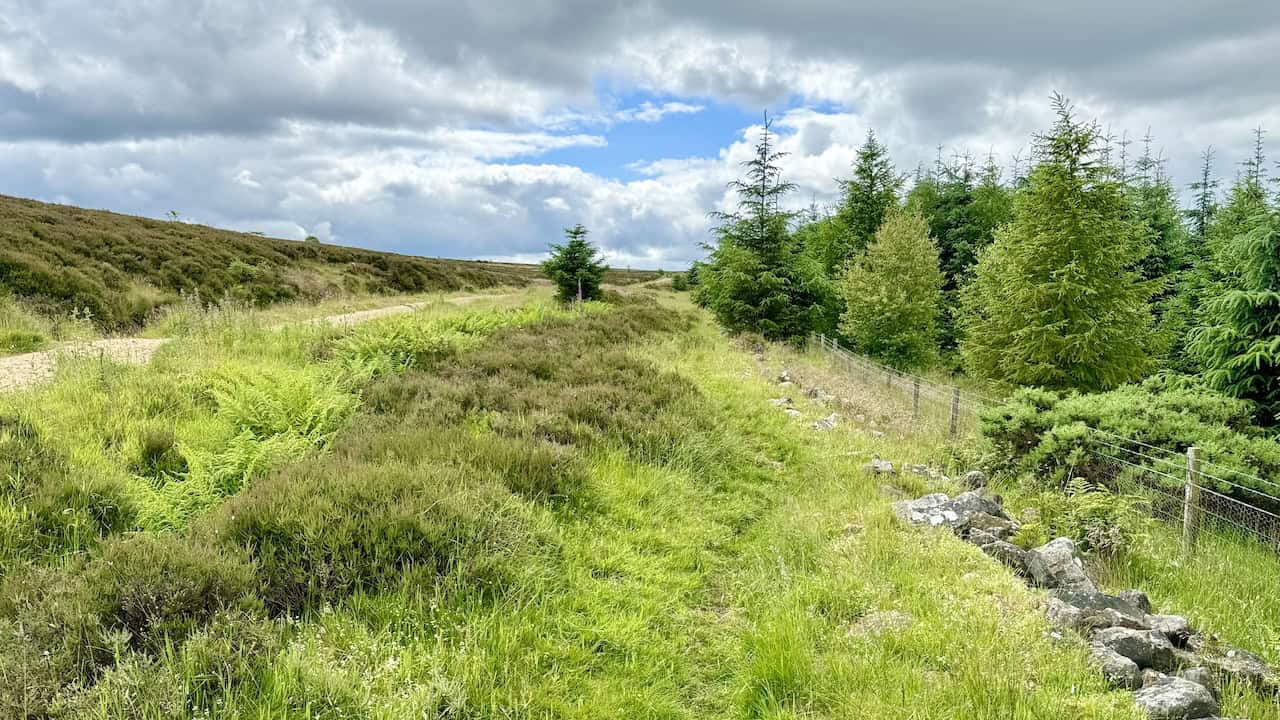
Progressing slightly further north from the triangulation pillar, the Cleveland Way footpath leaves the edge of the woodland and crosses Scarth Wood Moor. Just behind the wall on the right-hand side, but not in view, is a bench. If I am lucky enough, it may be free for a rest and to enjoy these magnificent views. But alas, someone is already sitting there.

This is the very easy-going stone-paved track across Scarth Wood Moor. It’s a pleasure to walk along, its elevated position affording great views ahead towards the Cleveland Hills, making it an enjoyable part of this awesome Osmotherley walk.
The view looking north as I cross Scarth Wood Moor shows the industry of Teesside around Middlesbrough and Billingham.

The view from Scarth Wood Moor to the north-east looks down to Swainby with Whorl Hill on the right.

After dropping down from Scarth Wood Moor and leaving the Cleveland Way, there is a short walk south along a minor road. The road has a footpath beside it, but to be honest, the road is quiet enough to walk along anyway. The road leads to a footbridge and ford known as the Sheepwash.

This is the footbridge and ford known as the Sheepwash near the northern end of Cod Beck Reservoir. The name possibly derives from shepherds bringing their sheep down from the surrounding moorland and washing them in the beck at the ford. The ford across Cod Beck was on an old drovers’ road between Scotland and the south of England, known as the Hambleton Drove Road. For this Osmotherley walk, I cross the bridge and continue up the track in the photo.

The stone track called High Lane leads south from the Sheepwash and is straightforward. It heads along the edge of the forest on the east side of Cod Beck Reservoir.
Eventually, High Lane (Track) reaches a small car parking area and then a minor road. It’s straight on along the road to Chequers. The hill in the background is called Black Hambleton, which reaches 400 metres.

There are great views down to Oak Dale from the road leading to Chequers.

Chequers was a legendary pub on the Hambleton Drove Road. It has also been a tearoom and is now a luxury guesthouse. The route for this Osmotherley walk goes slightly past Chequers, then right along a signposted public footpath leading down to Oak Dale.

On the track between Chequers and Oak Dale, there are lovely views north-west towards Osmotherley.

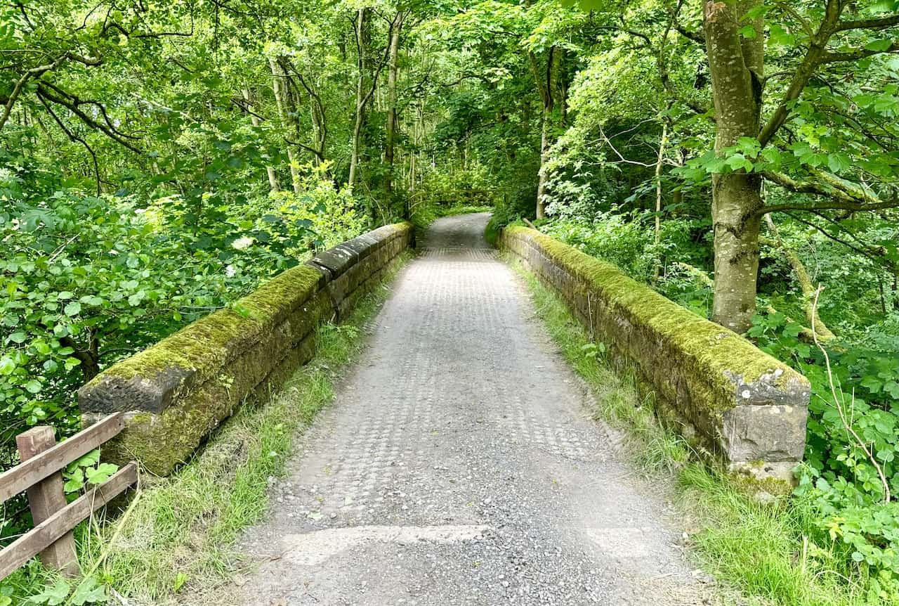
Back on the Cleveland Way, which crosses a bridge over a stream in the Oak Dale valley, I prepare for a bit of an incline out of the valley.
This beautiful garden is at the end of the track leading out of Oak Dale. The house is hidden behind the trees.

This is the track that leads down to Whitehouse Farm. But I turn right, following the sign for the Cleveland Way.

A footbridge crosses Cod Beck in a small, narrow valley on the eastern side of Osmotherley. I am ready for the tiring steps on the other side, leading uphill out of the valley.

Almost at the end of my Osmotherley walk now, a paved stone path leads back into the village.

From the paved stone path, the final part of this Osmotherley walk goes by the left-hand side of number 14, leading straight to the village.

Amazon’s Top Walking Boots: Four Standout Choices for Men and Women
For walking and hiking, the right boots are essential for both comfort and safety. While Amazon boasts a wide range, certain boots emerge as top-sellers. From those, here are four I personally favour. As an Amazon affiliate, I may earn a small commission from any purchases made through the links provided. This helps support the upkeep of this website. Rest assured, you won’t pay a penny extra, but your purchase will contribute to keeping my site running smoothly. Happy walking!

Berghaus Men’s Hillmaster II Gore-Tex Walking Boots
These fully waterproof leather walking boots feature a Gore-Tex lining, ensuring no water enters whilst allowing feet to breathe and stay cool. Made from full-grain leather, they promise unmatched durability and comfort. The boots come with memory foam tongues and cuffs that mould to your feet for a tailored fit, and the Vibram Hillmaster outsoles offer confidence on challenging terrains.

Salewa Men’s Mountain Trainer Mid Gore-Tex Walking Boots
Made from durable suede and abrasion-resistant textile, these men’s hiking boots are both lightweight and sturdy. The upper material is enhanced by a 360° full rubber sheath. Their dual-layer midsole with Bilight technology ensures ergonomic cushioning and grip, especially on extended hikes. The Vibram Wrapping Thread Combi outsoles allow a natural walking feel, and the Gore-Tex lining provides waterproofing, breathability, and optimal weather protection. Furthermore, the patented Salewa 3F system ensures flexibility, a secure heel grip, and a blister-free fit.

Berghaus Women’s Supalite II Gore-Tex Walking Boots
Specially designed for women, these hiking boots offer waterproofing and breathability, thanks to their Gore-Tex lining. Crafted from full-grain abrasion-resistant leather, they’re durable enough for the toughest hikes. The Supalite soles ensure stability and traction, and the EVA midsoles add comfort for extended walks.

Merrell Women’s Moab 3 Mid Gore-Tex Walking Boots
These hiking boots incorporate a Gore-Tex waterproof membrane, blending breathability with superior waterproof performance. The combination of pigskin leather and mesh on the uppers, along with the suede outer material, ensure durability and style. Enhancements include 100% recycled laces, webbing, and mesh lining. Additionally, bellows tongues, protective toe caps, and Vibram TC5+ rubber soles ensure protection and ease on any terrain.