Follow a Wensleydale Walking Route Featuring the Tupgill Park Estate
Begin your Tupgill Park walk at Wensley Bridge. There is a large tarmac roadside car park on the A684, situated next to Wensley Bridge just south of Wensley village. The car park lies on the south side of the River Ure.
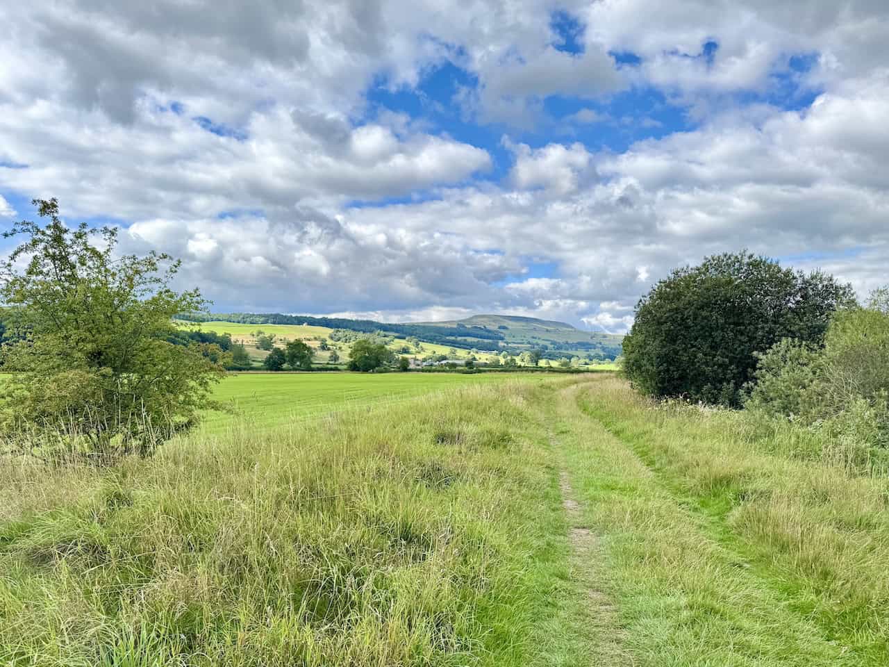
From the car park, cross the road and walk towards Wensley Bridge, but do not cross it. Just before the bridge, turn right onto the public footpath. If you are heading in the right direction, the River Ure will be on your left-hand side as you follow the path. Walk along the riverside for approximately 1½ miles, keeping the river close by on your left.
When the river bends sharply to the left, turn right and cross the field to meet a wide stone track. Turn left here and walk along the track. Continue until you meet the river again, then turn right onto a public bridleway near a large metal gate. Follow this bridleway uphill to the south, crossing a large field and entering a wooded area.
Continue on the bridleway through another couple of large fields. Follow the blue public bridleway waymarker arrows to stay on course. Eventually, you’ll reach a metal gate at a junction where a public footpath branches left and the bridleway continues right. Take the public footpath to the left and follow it along the edge of three more fields, heading east. As you progress, you’ll begin to see the tops of the houses in Middleham appearing ahead.
Eventually, you’ll reach a T-junction with another public footpath. Turn right and walk uphill. Just before reaching a row of bungalows at the top, turn left. Follow the path behind the backs of the houses to reach the top of St Alkelda’s Road. Continue straight ahead and take the path that leads to a children’s play area. Go straight on, passing the play area, and head towards the churchyard of the Church of St Mary and St Alkelda in Middleham.
Walk straight through the churchyard, passing the church entrance on your left, and continue through the stone archway to exit the grounds. Keep going straight ahead to reach the A6108. Turn right and walk uphill to the old stone cross on the cobbled area in Middleham’s Market Place. This marks roughly a quarter of the way around your Tupgill Park walk.
Turn right again, following Coverham Lane uphill towards Middleham Castle. Continue along this lane to reach Swine Cross, then turn left and walk up to the castle. Pass the front of the castle and turn right onto a tarmac road, which soon becomes a stone track. This public footpath, part of the Six Dales Trail, leads to Cover Banks. Shortly after passing the castle, take the public footpath through a dry stone wall on the right-hand side.
Follow the path across a couple of fields that are often used for grazing horses. Continue straight ahead with the dry stone wall and the road on your right-hand side. Follow the edge of the fields for about a quarter of a mile, then exit through a gate in the wall. Cross the road and go through a wooden gate to enter Middleham Low Moor. Here you’ll see an information sign reminding visitors to stick to public rights of way during racehorse training hours.
The route you’ll be following is marked in blue on the sign and follows a designated public bridleway. The bridleway crosses Middleham Low Moor from east to west. Roughly halfway across, the bridleway splits. You’ll be taking the left-hand fork, which gradually bears south and leads off the moor towards a well-defined stone track.
After familiarising yourself with the directions, start your crossing of Middleham Low Moor. At first, the grassy bridleway is visible underfoot, but it soon becomes indistinct. To stay on course, keep the racehorse gallops fairly close on your right as you continue west. These gallops are easy to identify, enclosed by white fencing.
Follow the line of the gallops for about a mile. Eventually, they will veer away and come to an end. This roughly marks a bridleway junction, although you may not see it clearly underfoot. At this point, take the more southerly or lower path, branching left across the open moor. Follow this route for another two-thirds of a mile, gradually descending towards the edge of the moor.
The path meets a stone track beside a dry stone wall. Continue straight ahead along the track with the wall on your left. A short distance later, turn left through two large stone pillars and follow a public bridleway downhill. Walk past a large house called Fern Gill on your left. Continue along the track, passing two ponds on the left. This is roughly the halfway point of your Tupgill Park walk.
Walk past the Fishing Temple on your left, then go through the large wrought iron gates marking the exit from Fern Gill House. Turn right and follow the tarmac lane uphill to a roundabout where the Tupgill Park welcome sign is displayed. With the entrance to the Forbidden Corner in front of you, turn right and follow the tarmac lane. This lane climbs uphill through Ashgill, part of the Tupgill Park Estate.
At the top of the hill, go through the gate to leave the estate and continue straight along a wide stone track. When you reach the road, continue forward and pass Havana House and Laurens Lodge, both part of Spigot Lodge. Stay on the road as it passes more Spigot Lodge dwellings. A little further along, turn left onto a public footpath.
The path runs alongside the edge of woodland before cutting across a large field. Pass the wind turbine as you walk, then exit the field and pass the front of some farm buildings before returning to open pasture. Follow the public footpath west for about half a mile, crossing three large fields. Eventually, the path meets a wider stone track that bends to the right and descends into woodland.
Do not follow the bend. Instead, continue straight ahead across more fields. As you progress, the houses of West Witton will come into view ahead, with the grassy slope of Capple Bank rising to your left. Keep to the public footpath and continue heading downhill for just over 1¼ miles, diagonally crossing around ten fields towards West Witton.
Eventually, the path emerges onto the A684. Turn left and walk into the village. When you reach the Fox & Hounds pub, turn right and follow the path to St Bartholomew’s Church. This marks roughly three-quarters of the way around your Tupgill Park walk.
Pass the church and walk straight through the graveyard along a slabbed path. This leads to a flight of stone steps that descend to a tarmac lane called Church Lane. Turn right and follow Church Lane steeply downhill. At the bottom, turn left onto another tarmac lane, Flats Lane, heading north.
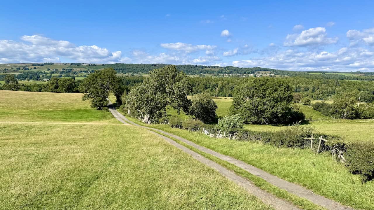
Continue along Flats Lane for about two-thirds of a mile, passing West Witton Farm. Keep following the lane as it bends right and leads past the front of High Wanlass Farm and its buildings. The track continues towards Low Wanless Farm, visible ahead. Walk past the right-hand side of the farm buildings. Then continue along the footpath through three more fields, heading towards the River Ure.
Soon you’ll reach a wooden fingerpost. Follow the public footpath signposted to Wensley Bridge. Cross several more fields for roughly half a mile, heading in the direction of Lords Bridge. Exit the final field onto a stone track. Turn left and head down towards Lords Bridge. Just before reaching it, turn right onto a riverside path with the River Ure on your left-hand side.
Follow the trail through woodland beside the river. The path may be slightly overgrown at first, but it soon becomes a lovely woodland walk, with the river close beside you on the left. Continue along the riverside path for just over a mile. Eventually, you’ll return to Wensley Bridge and the car park where you started, concluding your Tupgill Park walk.
Tupgill Park Walk: Maps and Tools
Visit either the OS Maps website or the Outdooractive website to view this walking route in greater detail. Both platforms offer a range of features, including the ability to print the route, download it to your device, and export the route as a GPX file. You can also watch a 3D fly-over and share the route on social media. Additionally, this page includes a printable version of the walk in PDF format. Plus there is a supporting video, available for you to watch on YouTube.
Tupgill Park Walk: Distance, Duration, Statistics
Distance: 11¼ miles
Distance: 18 kilometres
Duration: 5 hours
Ascent: 817 feet
Ascent: 249 metres
Type: Circular walk

Walking in the Yorkshire Dales with 43 Circular Routes
AD This Cicerone guidebook includes 43 circular walks exploring valleys, hills, and moors between Kirkby Stephen and Pateley Bridge. With OS maps, local highlights, and routes ranging from 3–11 miles, it is a year-round companion for walkers of all abilities.
Recommended Ordnance Survey Map
The best map to use on this walk is the Ordnance Survey map of the Yorkshire Dales Northern & Central Area, reference OS Explorer OL30, scale 1:25,000. It clearly displays footpaths, rights of way, open access land and vegetation on the ground, making it ideal for walking, running and hiking. The map can be purchased from Amazon in either a standard, paper version or a weatherproof, laminated version, as shown below.
Standard Version
About Tupgill Park
The Tupgill Park Estate near Middleham, Leyburn, North Yorkshire, is a vibrant destination known for its unique attractions, family-friendly amenities, and picturesque rural setting.
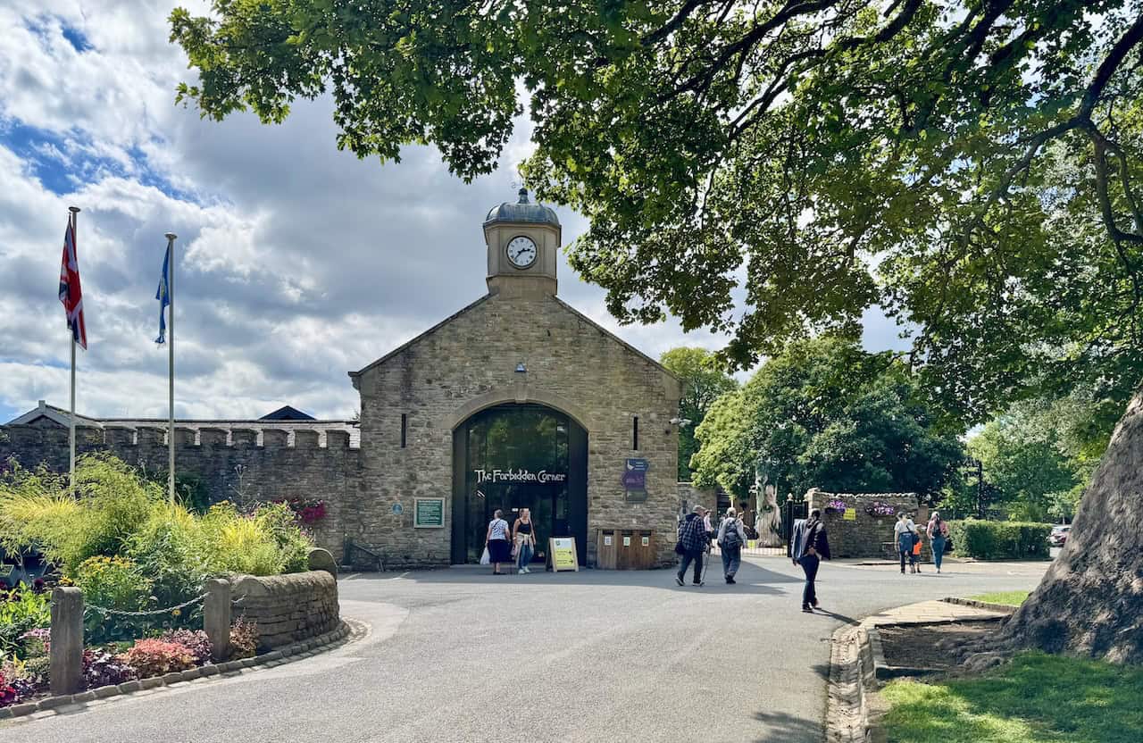
The Forbidden Corner at Tupgill Park is renowned as ‘the strangest place in the world’. It’s a celebrated labyrinth of tunnels, chambers, follies, and imaginative sculptures set within a four-acre garden. It’s a must-visit for families, adventurous visitors, and anyone looking for a truly unique day out in the Yorkshire Dales.
Tupgill Park also offers a range of self-catering holiday cottages with free Wi-Fi and on-site parking. The cottages are ideal for guests seeking a peaceful rural stay, with convenient access to the estate’s attractions, including The Forbidden Corner.
The Saddle Room is the estate’s on-site restaurant, known for its high-quality, locally sourced food and welcoming atmosphere. It’s perfect for rounding off a visit with a memorable meal or a local pint in a beautiful countryside setting.
Another highlight is the Herb Garden, created by Dennis Fawcett. It contains over 100 herbs displayed in thoughtfully designed raised beds, making it a popular spot for gardening enthusiasts and those looking for a calm, sensory experience.
The Fish Temple adds a touch of the unexpected to the estate. Once a horsebox used for animal health, it has been creatively repurposed as a whimsical feature that contributes to Tupgill Park’s distinctive character.
With over 500 acres of countryside and several public rights of way, Tupgill Park is also a great choice for walkers and nature lovers. Its footpaths and trails offer easy access to the unspoiled landscapes of Coverdale and the surrounding Yorkshire Dales.
Tupgill Park Walk: My Photos
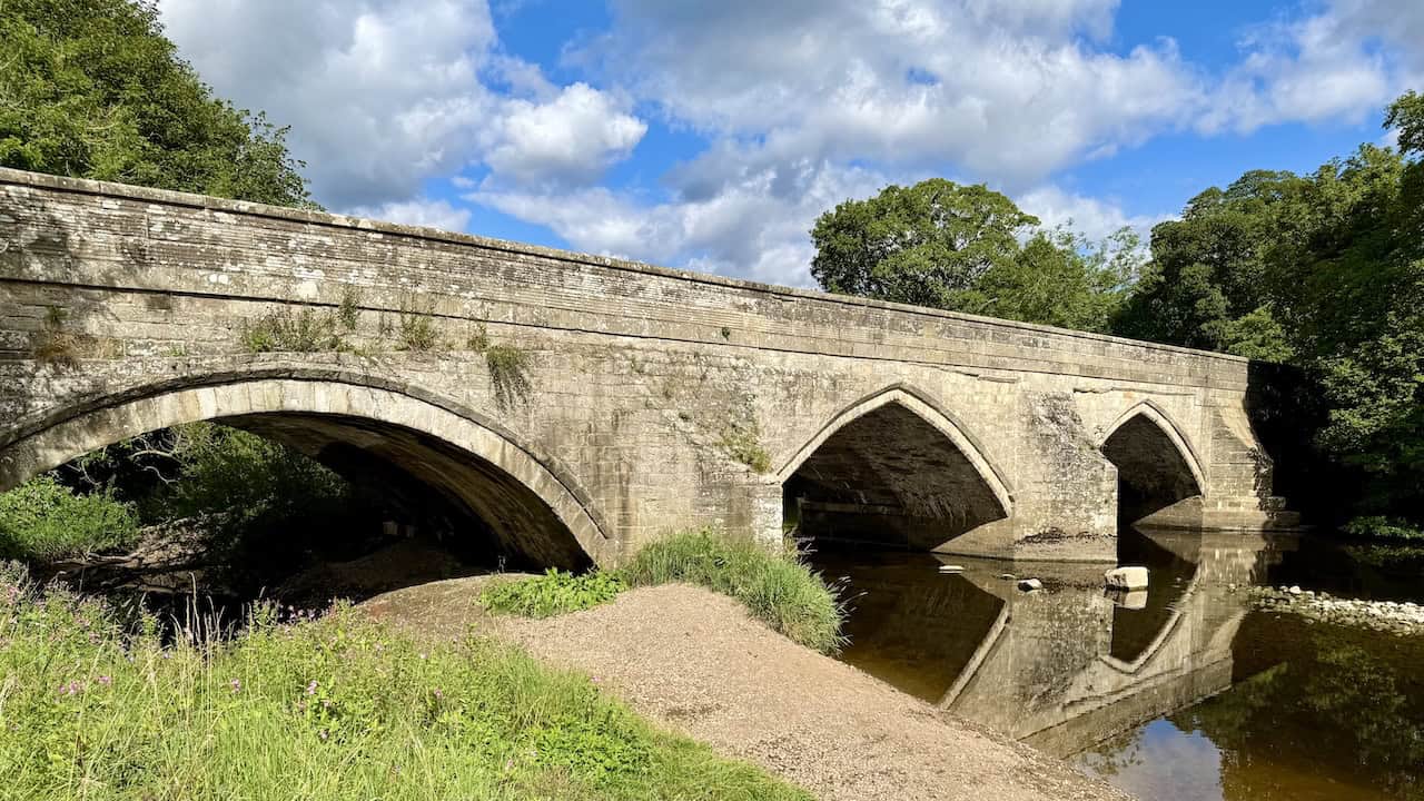
I start my Tupgill Park walk at Wensley Bridge, a historic stone structure spanning the River Ure. The early morning light catches its weathered stonework, and the calm water below creates a perfect reflection of the pointed arches. I can see two central pointed arches, likely dating to the 15th century. Adjacent to these is an 18th-century segmental arch, and beyond that, a semicircular arch from the early 19th century. According to historical records, Alwyne, the rector of Wensley, constructed the bridge before 1436. It was widened in 1818 and is now designated both as a Grade II listed building and a Scheduled Ancient Monument.

Grisport Unisex Adult Peaklander Hiking Boots
AD The Grisport Unisex Adult Peaklander Hiking Boots are crafted in Italy with a durable waxed leather upper, Spotex breathable lining, and a reliable Track-on rubber sole. Waterproof and weighing just 1120g, they offer comfort, resilience, and dependable performance on demanding trails.
Continuing east along the riverside path beside the River Ure, I glance back and catch a clear view of Penhill rising in the distance. Behind me, the wide grassy track stretches between open fields and a thick line of trees hiding the river, while soft light breaking through the cloud cover highlights the folds of the distant hillside.
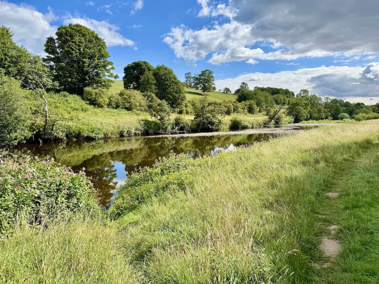
About halfway along the riverside path, the tall hedgerow that had been concealing the River Ure suddenly opens up, revealing a wide, open view. It’s a beautiful day. The river runs low and steady, its surface reflecting the trees and sky on the opposite bank. The grassy path underfoot is easy to follow, comfortable to walk on, and keeps me close to the water’s edge as I continue east.
Grisport Unisex Adult Peaklander Hiking Boots
AD The Grisport Unisex Adult Peaklander Hiking Boots are crafted in Italy with a durable waxed leather upper, Spotex breathable lining, and a reliable Track-on rubber sole. Waterproof and weighing just 1120g, they offer comfort, resilience, and dependable performance on demanding trails.
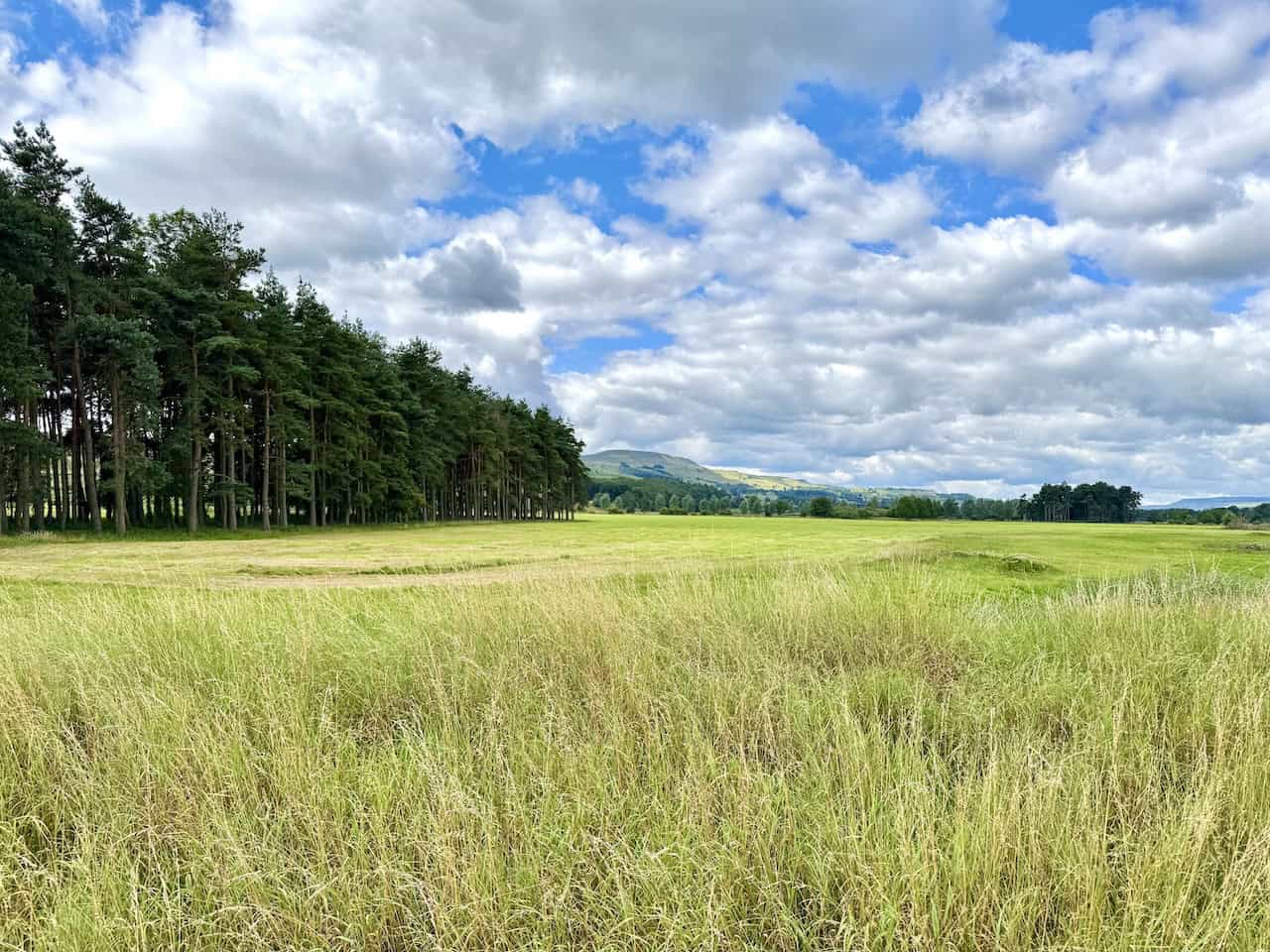
I reach the edge of a quiet belt of woodland next to an open area known as The Wishings. From here, Penhill remains in view on the horizon, its broad shape rising gently above the patchwork of fields and trees. The contrast between the dense pines and the open pasture makes this a striking point in the Tupgill Park walk, and the wide skies add to the sense of space.
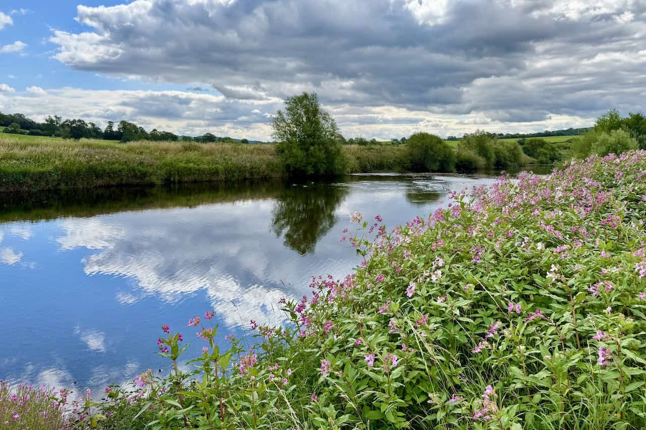
Just beyond the woodland, I reach a slower, deeper stretch of the River Ure. A thick fringe of Himalayan balsam lines the bank, their pink flowers leaning over the edge as if admiring their reflection. The sky is heavy with cloud, but there’s no chance of rain according to the forecast. The river remains still, catching the light and mirroring every detail with perfect clarity. It’s a peaceful moment in the walk, and I pause here for a while to take it in.

Fifty Walks Across the Beautiful North York Moors National Park
AD Discover 50 routes across the North York Moors, from short easy strolls to challenging high-level hikes. With OS maps, route descriptions, and local highlights, it also includes the legendary 40-mile Lyke Wake Walk, described in four accessible stages.
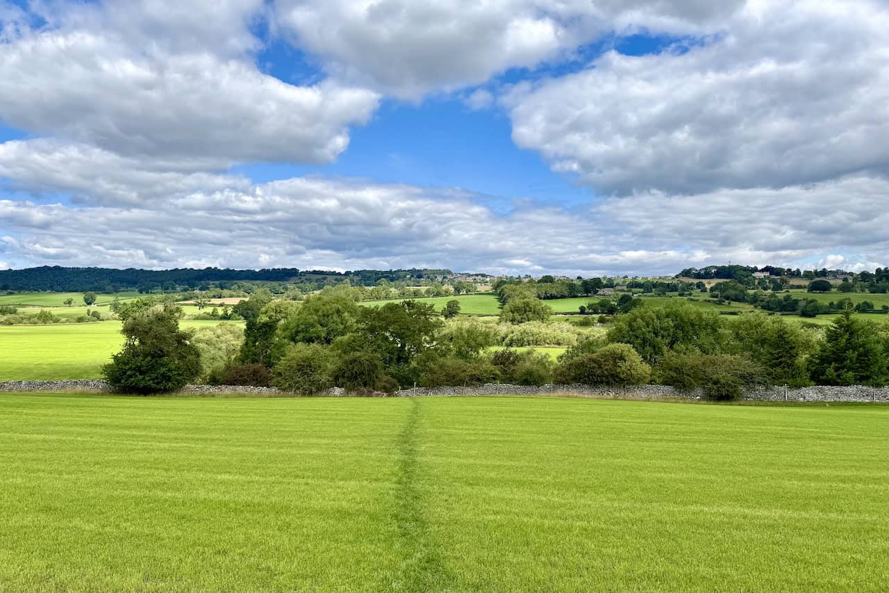
After leaving the River Ure, I follow a bridleway south across a wide, open field of bright green grass. When I glance back, I’m treated to a distant, elevated view of Leyburn on the horizon. The village catches the light between bands of trees and pasture, framed by a long line of woodland. It’s one of those views that makes you stop and take it all in.
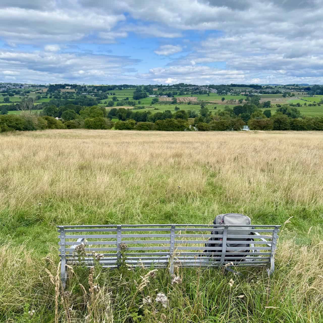
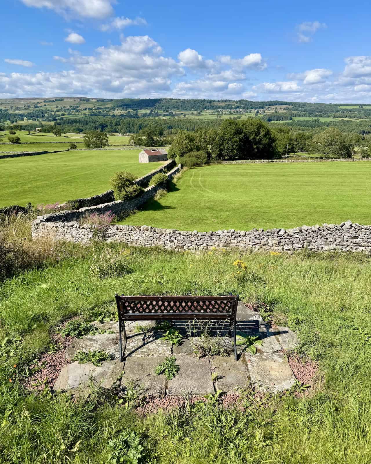
I’m nearly in Middleham now, following a quiet path along the back of a row of houses when I come across this well-placed bench. It’s the perfect spot for a coffee and a snack, with a wide view across the fields towards Harmby. My pack rests beside me as I pause and take in the layered green of the valley, scattered with farms, hedgerows, and distant rooftops.
Fifty Walks Across the Beautiful North York Moors National Park
AD Discover 50 routes across the North York Moors, from short easy strolls to challenging high-level hikes. With OS maps, route descriptions, and local highlights, it also includes the legendary 40-mile Lyke Wake Walk, described in four accessible stages.
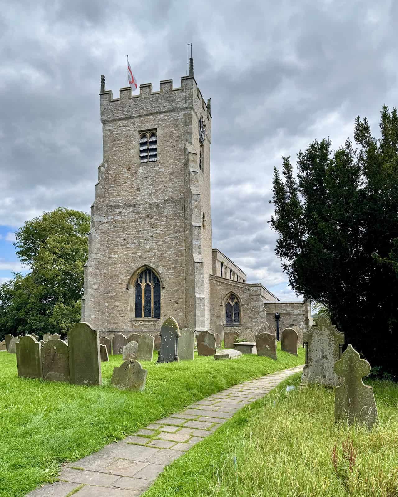
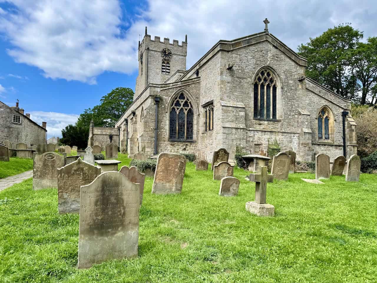
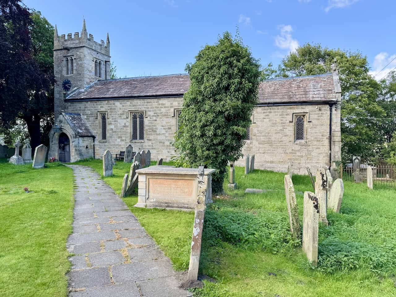
Now in Middleham, I reach the top of St Alkelda’s Road and carry straight on, following the path that leads to a children’s play area. From there, I head into the peaceful churchyard of the Church of St Mary and St Alkelda. The tower rises solid and square above the old gravestones, flying the flag of St George, and the flagged stone path draws me gently towards the church entrance.
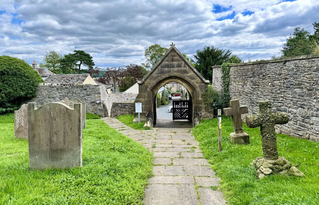
I leave the church through a striking stone archway at the far end of the churchyard, its pointed shape framing the quiet street beyond. Just before I reach it, I pass two unusual stone crosses on the right, one of them thick with carved ivy, as if nature itself has claimed it. The flagged path leads me between rows of gravestones and through a sturdy wooden gate, back into the heart of Middleham.

Osprey Hikelite Unisex Backpack for Comfortable and Lightweight Hiking
AD The Osprey Hikelite backpack combines lightweight design with practical features, including a breathable mesh back panel, soft webbing straps, and stretch mesh water bottle pockets. With zipped storage and an organiser compartment, it is ideal for day hikes and outdoor use.
I pause and glance back at the Church of St Mary and St Alkelda as I leave the churchyard. The building dates from the 13th century and was designated a Grade I listed structure in 1967. It became a collegiate church in 1477 under Richard, Duke of Gloucester, who established a body of clergy that included a dean, six chaplains, four clerks, and six choristers. Richard’s son, Edward of Middleham, Prince of Wales, is thought to have been buried here following his death nearby at Middleham Castle in 1484. The church remained a Royal Peculiar until 1856, when the office of Dean was replaced by that of Rector.
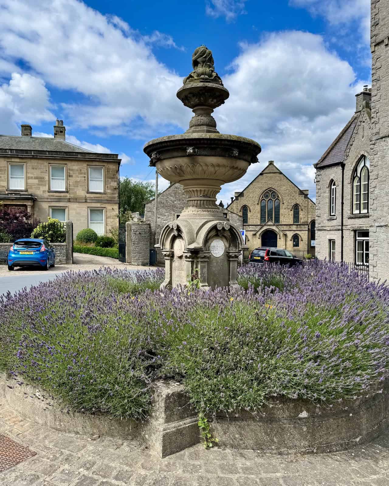
After leaving the church, I walk up to the old stone cross on the cobbled area in Middleham’s Market Place, then follow Coverham Lane to reach Swine Market—a lovely spot just a minute or so away. In the centre stands the Jubilee Fountain, built to commemorate Queen Victoria’s Golden Jubilee and funded by public subscription. It’s a striking piece of stonework, completed at a cost of £150 and originally fed by a water supply from the upper Dales. Although the fountain still works, it was turned off at the request of local residents—the slightest breeze was enough to soak anyone walking past. Today, it’s surrounded by lavender and quietly watched over by the buildings of the square.
Osprey Hikelite Unisex Backpack for Comfortable and Lightweight Hiking
AD The Osprey Hikelite backpack combines lightweight design with practical features, including a breathable mesh back panel, soft webbing straps, and stretch mesh water bottle pockets. With zipped storage and an organiser compartment, it is ideal for day hikes and outdoor use.
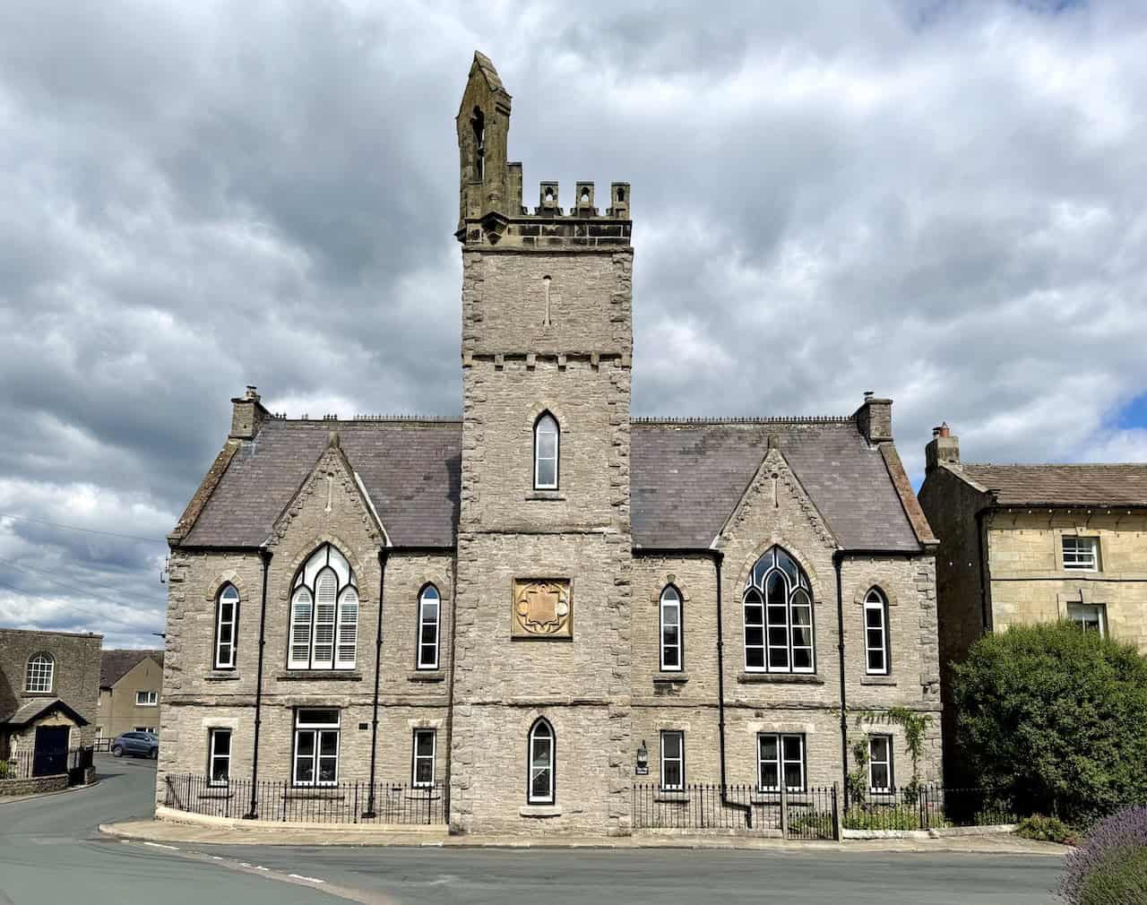
Just across from the Jubilee Fountain stands The Old School, built in 1869 in the Victorian Gothic style. It served as the local schoolhouse for many years, and the bell still hangs proudly in the tower above. Since closing as a school, the building has taken on various roles—a gallery, a tearoom, and an arts and crafts workshop—before eventually becoming a private home. Lit by the bright morning sun, its arched windows and steep gables still give it a strong sense of presence in the heart of Middleham. I love this building, and in fact, the whole town. I’m roughly a quarter of the way around my Tupgill Park walk.
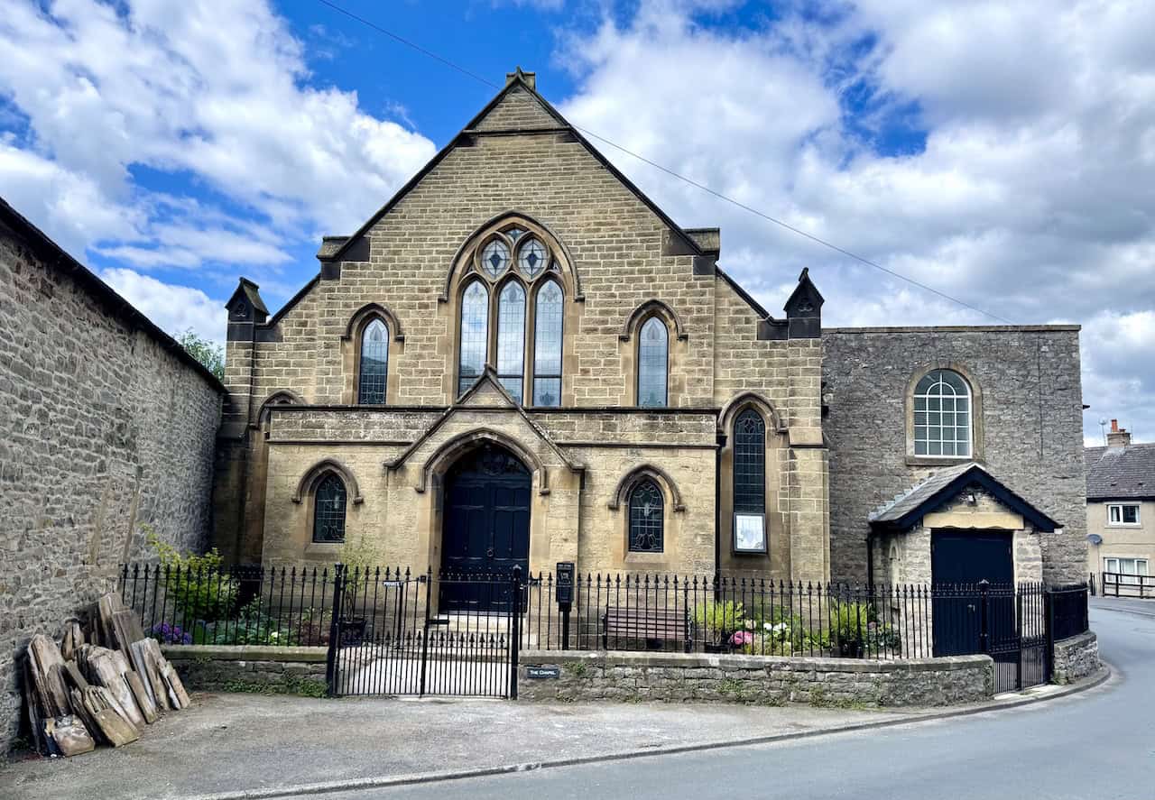
Next to the old school is Middleham’s former Methodist Church, a handsome building that reflects the strong Methodist tradition once rooted in the Dales. Enlarged in 1914 to serve a growing congregation, it stands directly across from the original chapel, which has since been converted into a private home. The church closed its doors for worship in February 2019 and has since been sold, but its pointed-arch windows and symmetrical façade still speak of its proud past.

Peak Bagging Wainwrights with Routes to Complete All Fells
AD This comprehensive guide offers 45 circular routes linking all 214 Wainwright fells. With maps, GPX downloads, elevation profiles, and practical advice, it provides efficient yet inspiring ways to complete this classic Lake District challenge at your own pace.
Middleham Castle
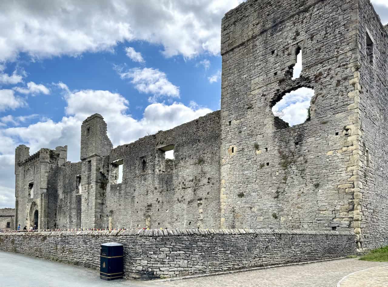
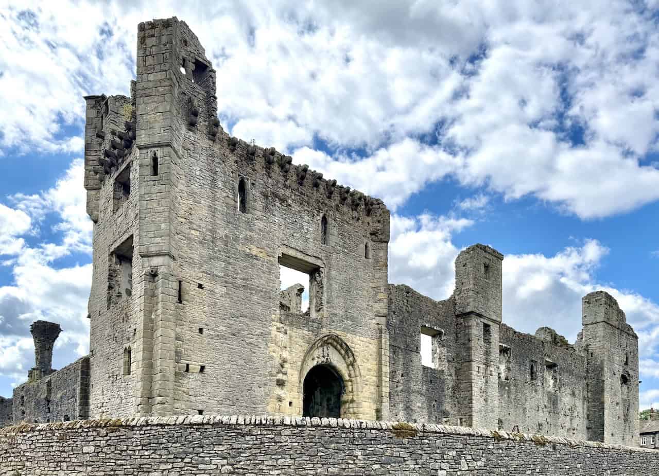
Just around the corner, I come to the commanding remains of Middleham Castle, a structure that has dominated this part of Wensleydale since the late 12th century. It was begun around 1190 by Robert FitzRandolph, 3rd Lord of Middleham and Spennithorne. Richard III spent much of his youth here, though little of his reign. The castle’s position was chosen to guard the road between Richmond and Skipton, though some argue that a nearby earlier site would have offered better defence. Following Richard’s death, the castle stayed in royal hands until the 17th century, when it was left to decay. Over time, its stones were scavenged for use in the surrounding town.
Walking past the north-east side, I catch sight of the tall 15th-century tower that serves as the main entrance. The original gateway, located to the east, led into an outer courtyard, though only its foundations remain today. Later modifications in the 14th century included the addition of turrets and a defensive arch, along with carefully designed openings in the walls for archers and defenders. Despite its ruined state, the outer wall still forms an almost complete circuit, giving a clear impression of the castle’s once-formidable footprint.
Peak Bagging Wainwrights with Routes to Complete All Fells
AD This comprehensive guide offers 45 circular routes linking all 214 Wainwright fells. With maps, GPX downloads, elevation profiles, and practical advice, it provides efficient yet inspiring ways to complete this classic Lake District challenge at your own pace.
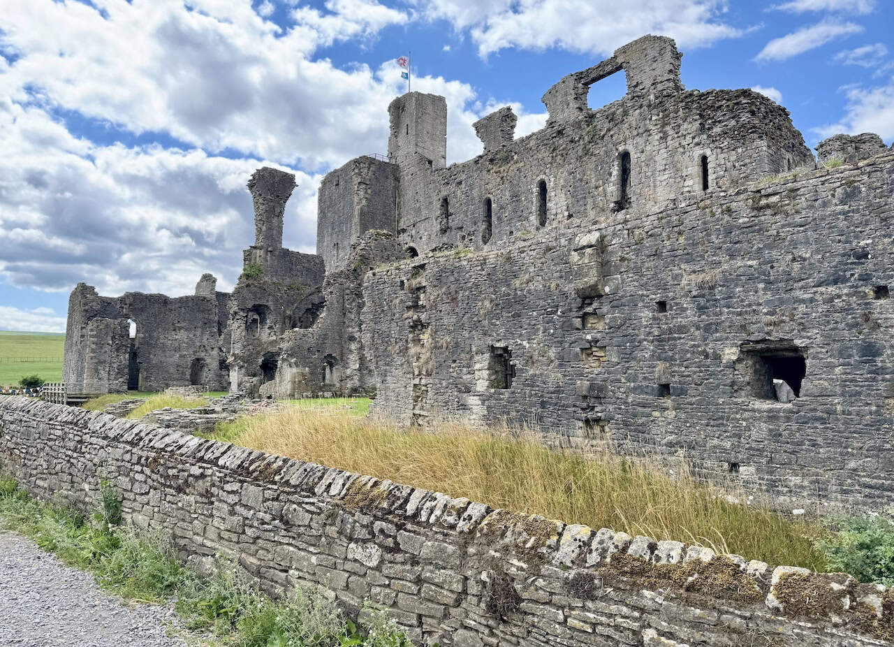
At the centre of the castle lies a colossal Norman keep—among the largest in England. It’s rectangular in plan, with thick walls and towers placed at the corners and midway along each side. Inside, a dividing wall separates the space into two levels: the lower level contains vaulted chambers, while the upper features grand halls illuminated by tall, narrow windows. A chapel was added later near the first-floor entrance. In the 15th century, the influential Neville family transformed the fortress into a lavish residence, building additional living quarters and linking them to the keep with elevated walkways. Though much of the upper structure has collapsed, the scale and setting of Middleham Castle remain deeply atmospheric.
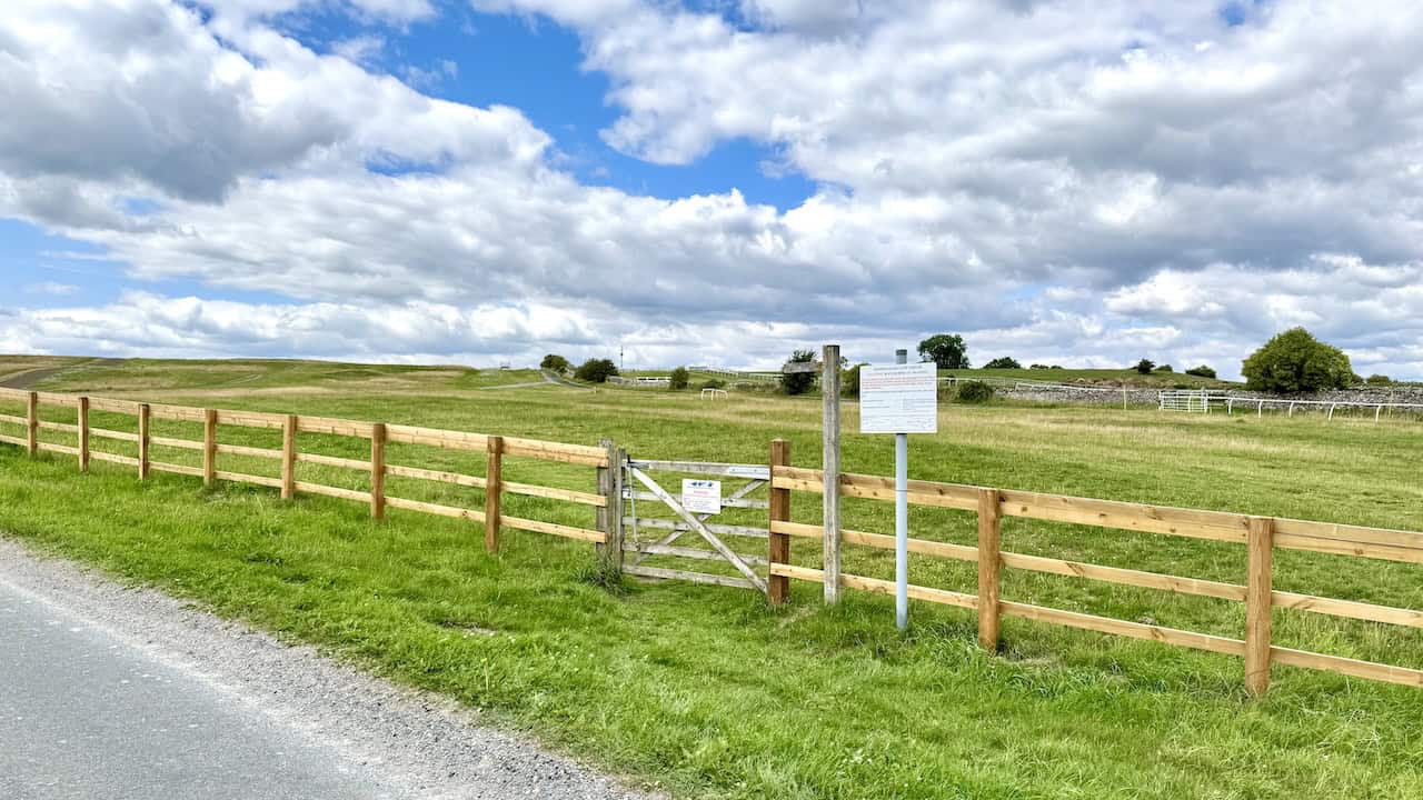
Leaving the town of Middleham, I arrive at the gateway to Middleham Low Moor, where a wooden gate and newly fenced access point lead out onto wide, open moorland. In the distance, the distinctive white rails of the gallops cut across the gently undulating landscape, hinting at the area’s racing heritage. It’s a peaceful, spacious scene with uninterrupted skies. Next to the gate, a large information board warns of restrictions during racehorse training hours. Under the Countryside and Rights of Way Act 2000, there’s no right of access across the land between dawn and midday, or at any other time when training is underway. During these periods, walkers must stick to public rights of way or the permissive bridleways. The sign explains that training typically takes place daily between 6 am and 1 pm and includes a clear map showing the designated paths, gallops, and access boundaries. As I’ll be following the bridleway across the moor, I know I’ll be staying within the rules.

Berghaus Hillmaster II GTX Men's High Rise Hiking Boots
AD The Berghaus Hillmaster II GTX men’s hiking boots feature a waterproof, breathable GORE-TEX membrane, a memory foam tongue and collar for a personalised fit, and a Vibram sole delivering exceptional grip, stability, and shock protection for confident performance on any terrain.
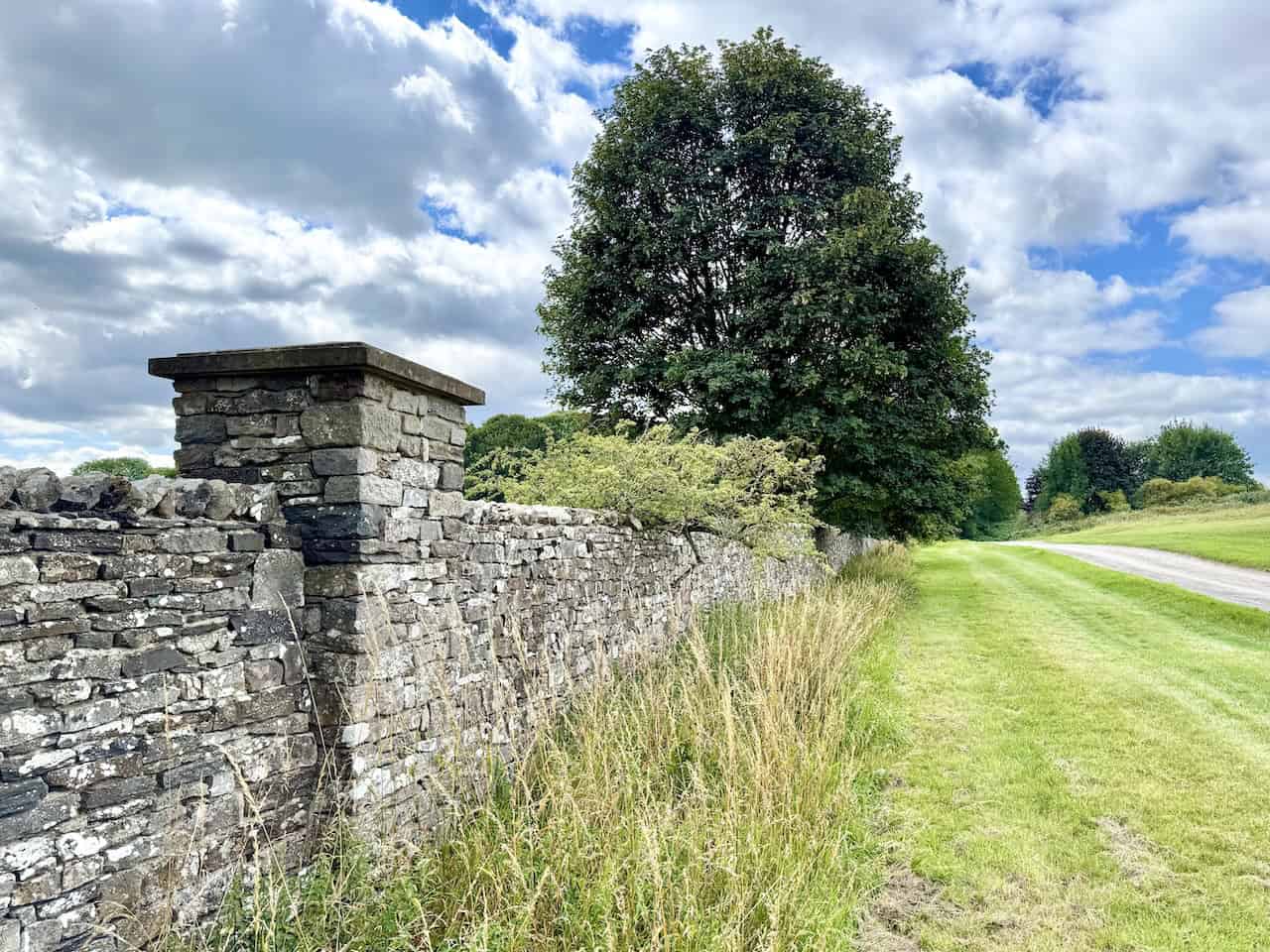
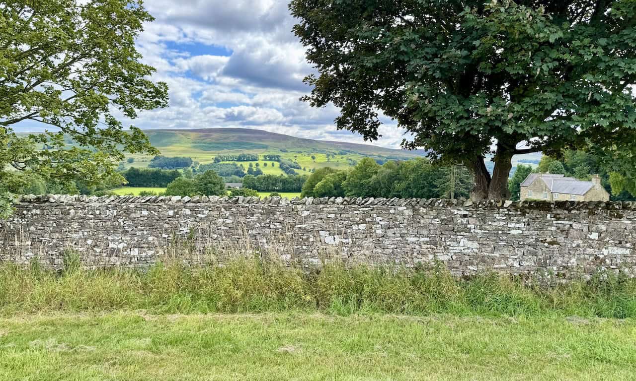
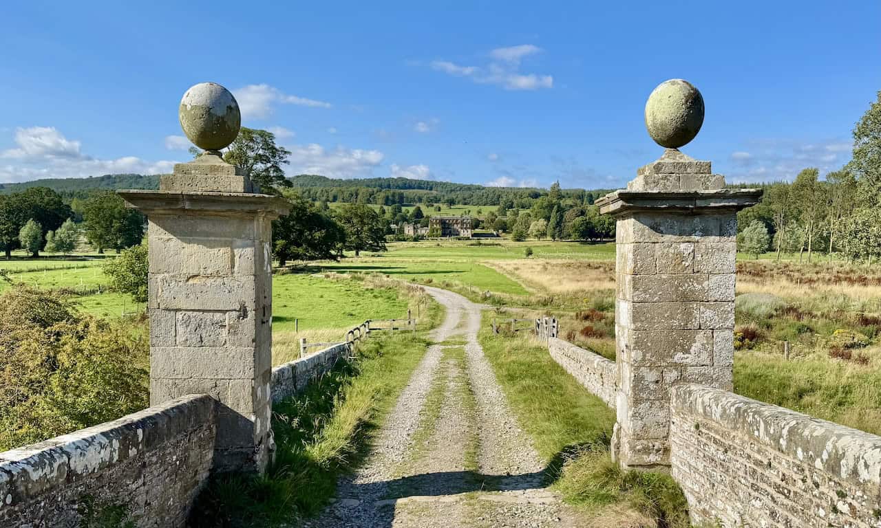
I cross Middleham Low Moor by way of the bridleway, a stretch that’s nearly two miles long. The terrain is gentle, and the reasonably short-cropped grass makes for easy walking, but the route itself isn’t always obvious underfoot. With no clear line to follow, careful navigation is needed. Eventually, I reach the far side of the moor and join a broader stone track that runs beside a tall dry stone wall, which encloses Tupgill Park.
Peering over the dry stone wall, I take in a broad sweep of green fields stretching across the valley. The landscape is gently layered, with hedgerows and scattered trees marking the boundaries between pastures. Sunlight breaks through the drifting clouds, casting soft golden patches across the slopes and lighting up the folds of the land with a warm, inviting glow. In the distance, the rising ground of Braithwaite Moor is capped by the distinctive outline of Flamstone Pin, standing dark against the sky.
Berghaus Hillmaster II GTX Men's High Rise Hiking Boots
AD The Berghaus Hillmaster II GTX men’s hiking boots feature a waterproof, breathable GORE-TEX membrane, a memory foam tongue and collar for a personalised fit, and a Vibram sole delivering exceptional grip, stability, and shock protection for confident performance on any terrain.
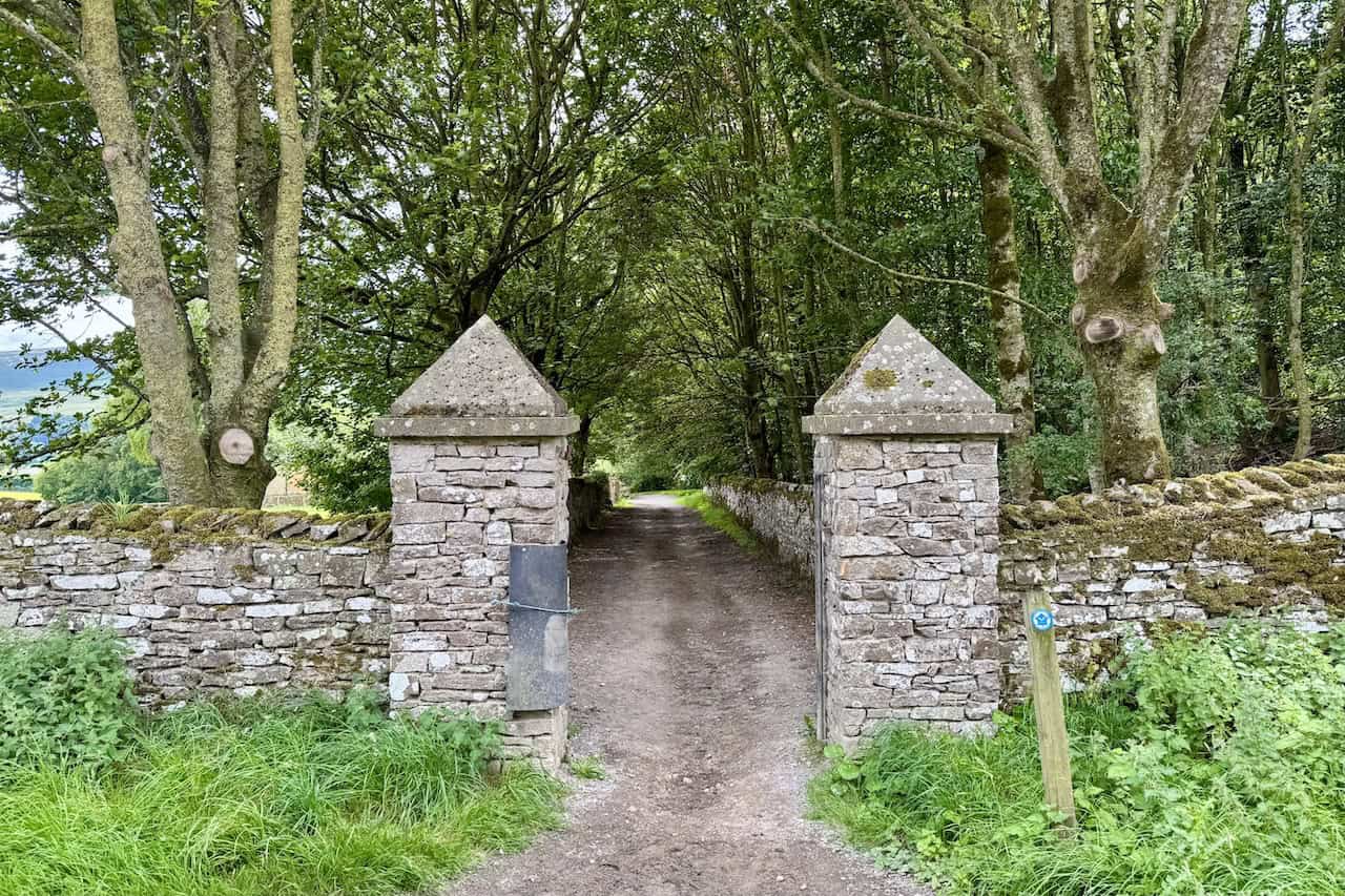
From the wide stone track, I turn left through a pair of impressive gateposts with pointed caps. The path leads invitingly into a shady tunnel of trees, with dry stone walls lining both sides. This marks the entrance into Tupgill Park, where the woodland track promises a peaceful change of pace from the open moorland behind me.
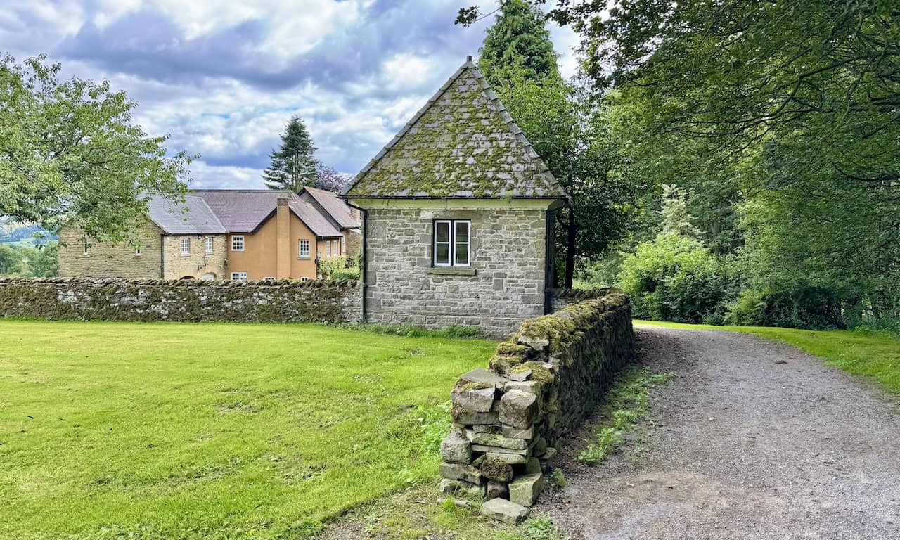
Almost as soon as I enter Tupgill Park, I pass a curious little stone building tucked beside the path, not far from Fern Gill House. Its steep, moss-covered roof and solitary window give it an almost storybook appearance, though its original purpose remains unclear to me. Surrounded by neat lawns and dry stone walls, it adds a quiet charm to this peaceful corner of the estate.

Kendal Mint Co Energy Gel with Citrus and Mint Flavour
AD Kendal Mint Co energy gels deliver 27g of fast-absorbing carbohydrates plus electrolytes and B vitamins for improved performance. Vegan, gluten free, and Informed Sport certified, these caffeine-free gels are refreshing, easy to digest, and ideal for running, cycling, and endurance.
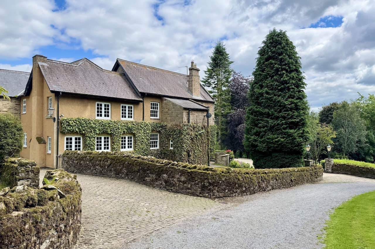
I walk past Fern Gill House, a handsome and well-kept property nestled within the grounds of Tupgill Park. The house blends rendered and stone-built sections, with climbing plants softening its façade and winding around neat rows of white-framed windows. Moss-covered walls and a cobbled drive lend a sense of age and character, while carefully trimmed hedges and tall conifers give the grounds a sheltered, secluded feel. It’s a beautiful and very elegant house.
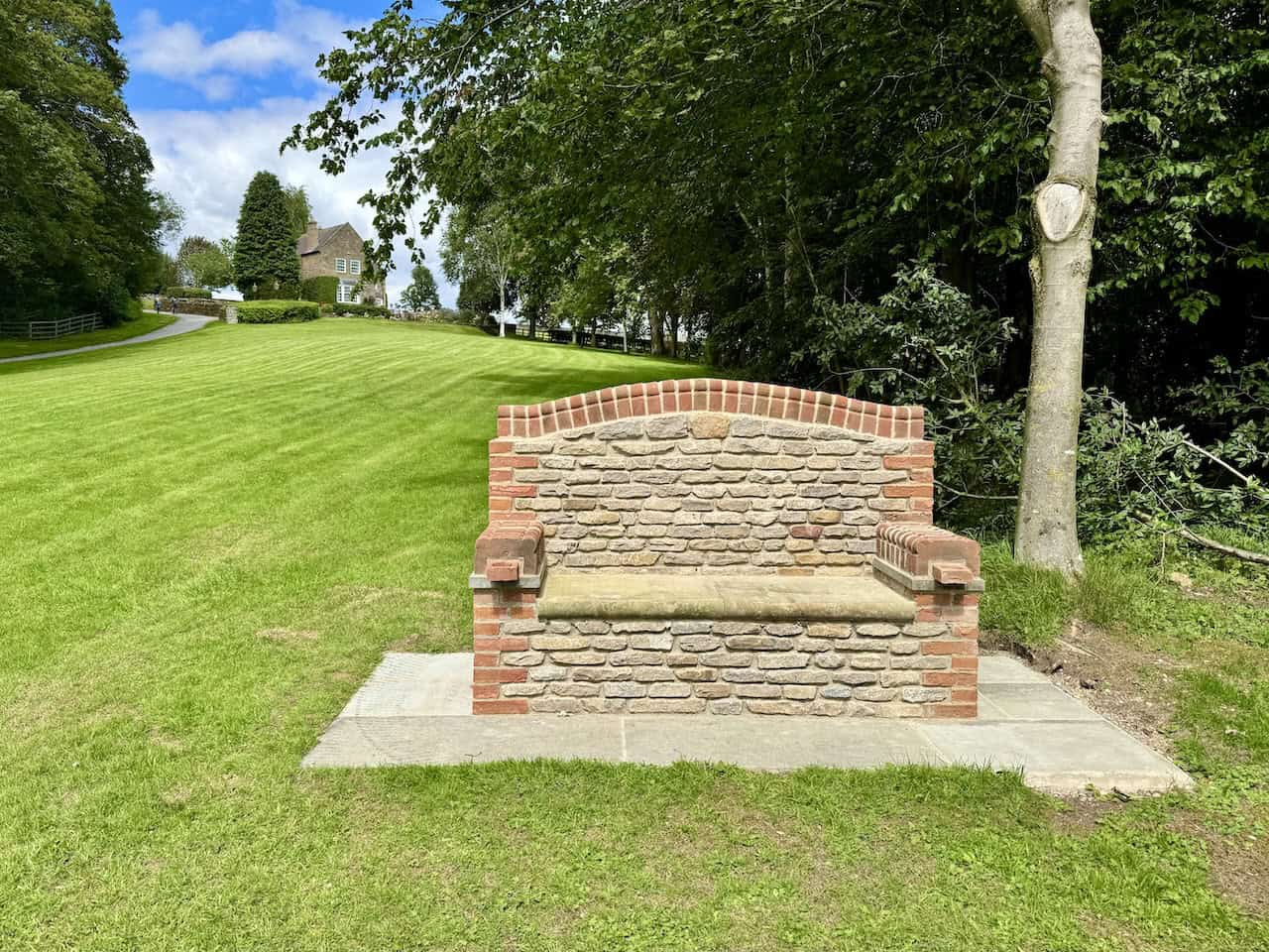
A little further along the bridleway from Fern Gill House, I come across a charming seat set in a quiet corner of the park. Constructed from a mix of bricks and neatly laid stone, it blends beautifully with its surroundings and provides a great view of the park, which I’m about to walk through. From the front, it looks simple and inviting, nestled against a backdrop of trees and lush lawn. From the back, I discover the reason for its presence. A small plaque reveals this is ‘Leo’s Seat’, dedicated to someone who passed away in December 2024.
Kendal Mint Co Energy Gel with Citrus and Mint Flavour
AD Kendal Mint Co energy gels deliver 27g of fast-absorbing carbohydrates plus electrolytes and B vitamins for improved performance. Vegan, gluten free, and Informed Sport certified, these caffeine-free gels are refreshing, easy to digest, and ideal for running, cycling, and endurance.
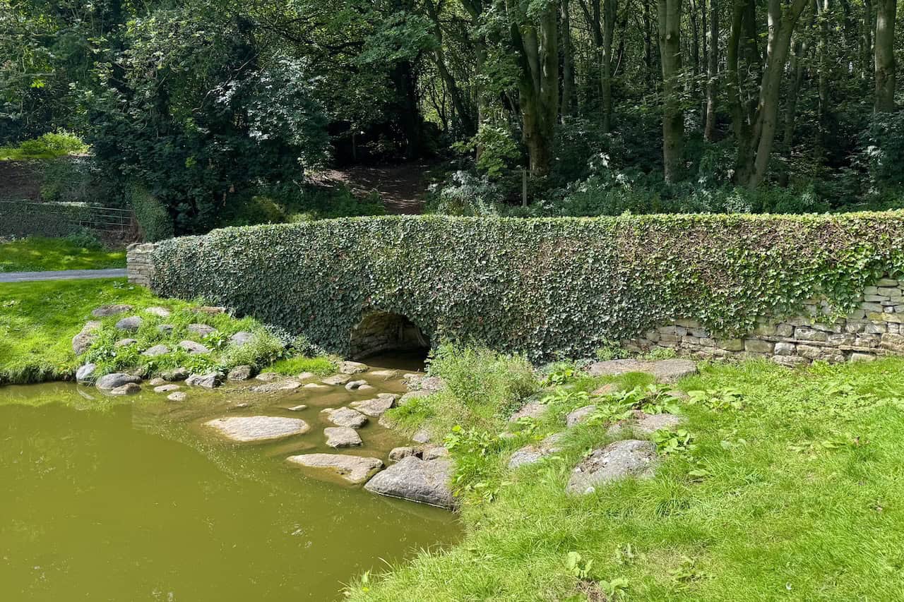
The bridleway takes me across an ivy-clad stone bridge that arches neatly over a stream flowing into two ornamental ponds. It’s a peaceful and picturesque spot, with flat stones scattered in the shallows and broad-leaved plants softening the banks. I notice a path leading into the trees, where dappled light filters through the canopy. It looks inviting, and it’s another right of way, but it’s not the one I’ll be following on this Tupgill Park walk.
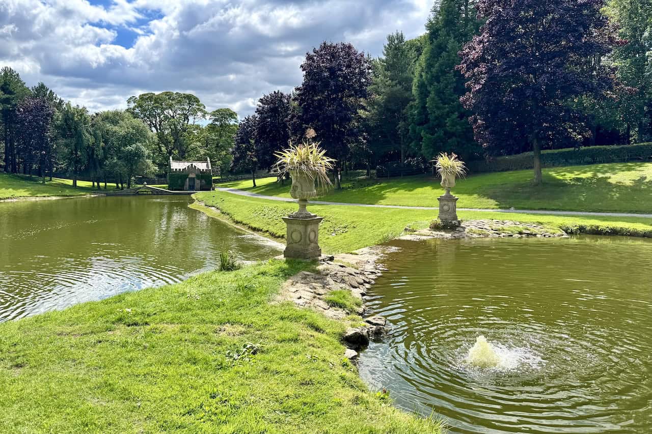
I pause near the bridge to take in a spectacular view across the ornamental ponds. Two lovely stone statues stand proudly above the rippling water. A gentle fountain bubbles in the foreground. Beyond the far pond, a charming building sits framed by tall trees, while the winding path curves gracefully through the well-kept lawns of Tupgill Park. It’s a lovely day, and this place is amazing, so I decide to find somewhere to sit and enjoy lunch.

Thermos Stainless King Flask for Travel and Daily Adventures
AD The Thermos Stainless King 470ml flask keeps drinks hot for 18 hours or cold for 24. With durable stainless steel, vacuum insulation, a serving cup, and a leakproof design, it is perfect for commutes, journeys, and outdoor adventures.
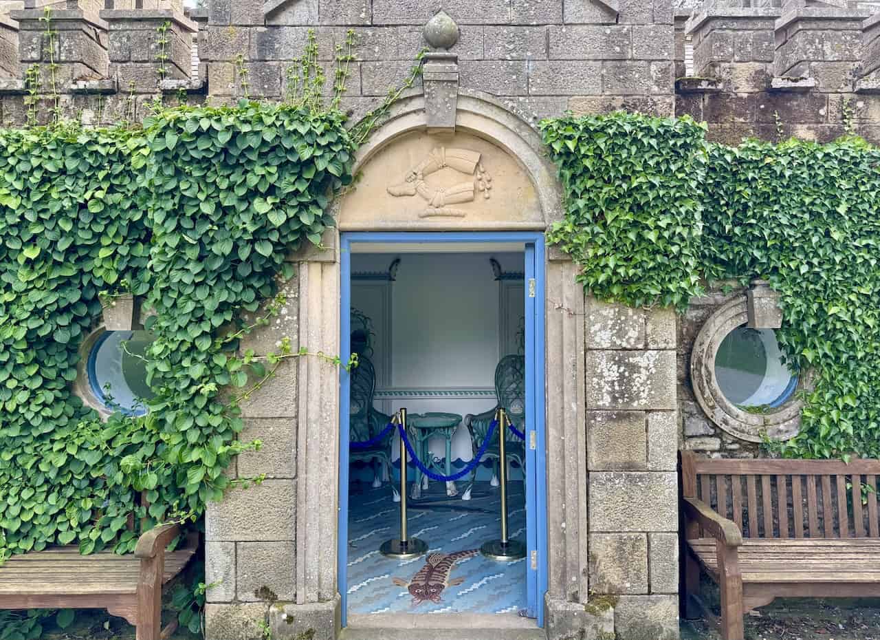
I reach the Fishing Temple, a striking little stone building draped in green ivy and tucked beside a gracefully arched bridge. Originally built in 1910 as a water box for horses’ health, it’s now a quiet spot for rest and reflection. A blue plaque on the wall tells the story of its past and labels it as ‘an area for contemplation, thought and rest’. Benches outside the entrance provide a peaceful place to sit and admire the surroundings. With the gentle ripples of the pond just beyond and mature trees forming a protective canopy, it’s one of the most tranquil corners of Tupgill Park.
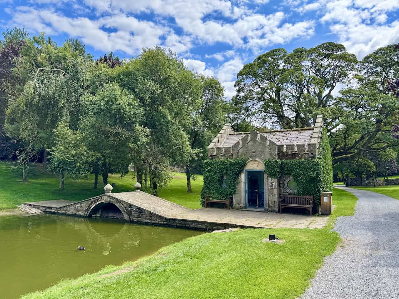
From the outside, the Fishing Temple is an eccentric little building, with ivy creeping across its stonework and a pair of round windows flanking a blue-painted door. Benches on either side of the entrance invite walkers to pause and take in the peaceful view across the lake. Above the doorway, a curious stone carving shows what appears to be an arm and hand holding a leg—though its meaning isn’t clear to me, it adds to the temple’s quirky and slightly surreal charm.
Thermos Stainless King Flask for Travel and Daily Adventures
AD The Thermos Stainless King 470ml flask keeps drinks hot for 18 hours or cold for 24. With durable stainless steel, vacuum insulation, a serving cup, and a leakproof design, it is perfect for commutes, journeys, and outdoor adventures.
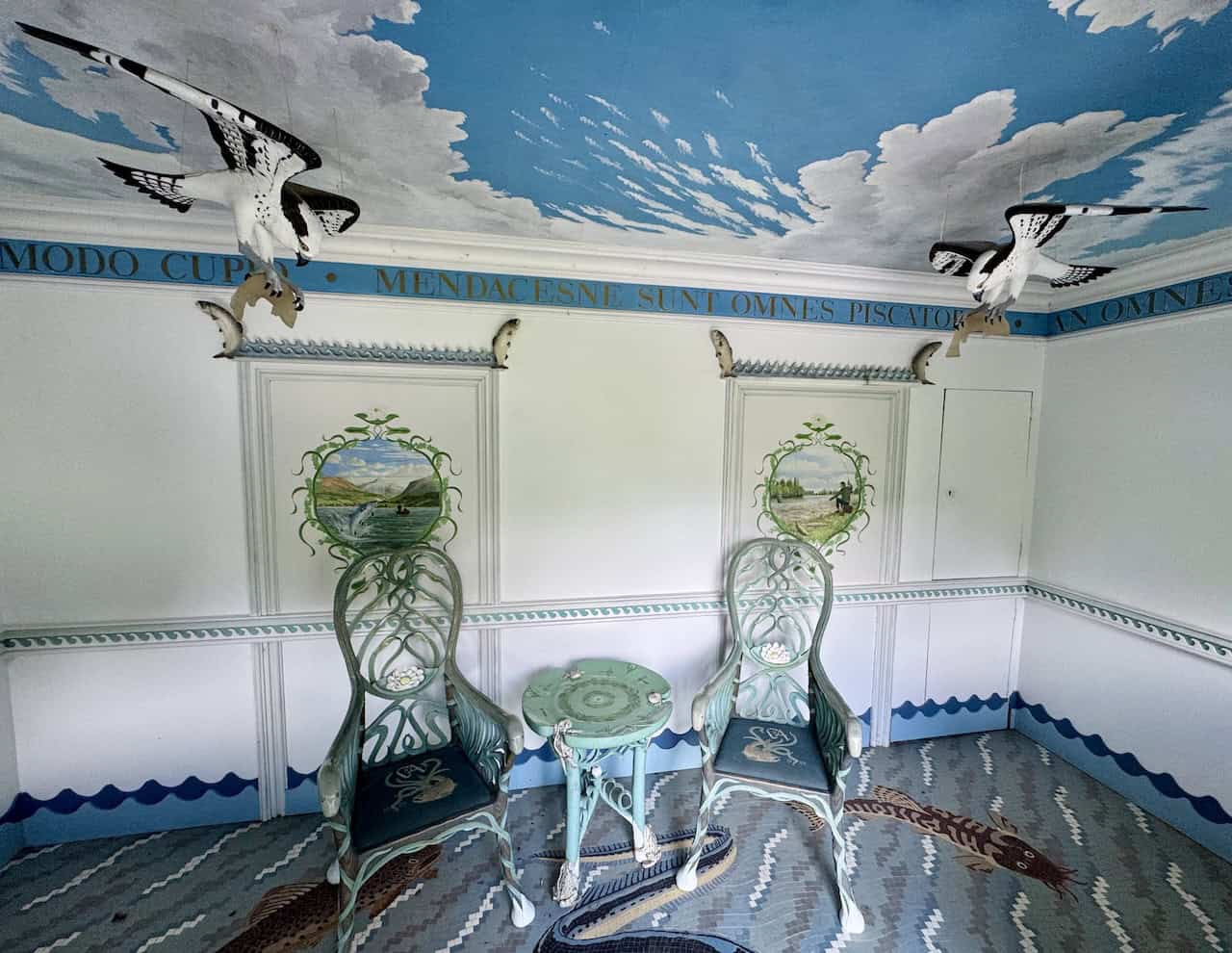
Inside, the building is intricately decorated, with hand-painted furniture, mosaic flooring, and a ceiling painted with blue sky and clouds. Two birds hang from above—Ospreys, perhaps—frozen mid-flight, fish in their claws, while the walls feature painted scenes of fishing on the lake. Latin text runs around the cornice, and everything from the chairs to the floor tiles reflects the angling theme.
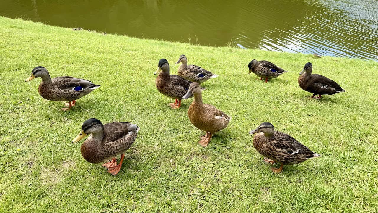
As I settle down on one of the benches near the Fishing Temple to enjoy my lunch, I’m quickly joined by an inquisitive group of ducks. They waddle up confidently across the grass, clearly well-practised in scoping out picnickers for potential snacks. Their feathers catch the light—rich brown patterns with flashes of blue—and they stand watching me expectantly, as if waiting for me to drop a crumb or two.
Lake District High Level and Fell Walks with Thirty Routes
AD This pocket-sized guide presents 30 routes on the Lake District’s highest fells, including Scafell Pike, Helvellyn, and Blencathra. With OS maps, colour photographs, and practical notes, it offers circular walks from 4–15 miles graded by difficulty.
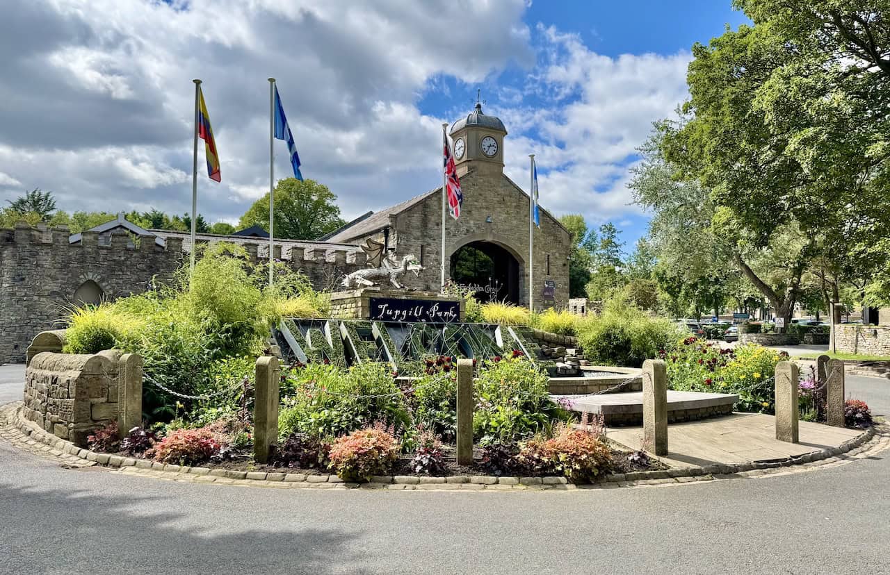
After my lunch, I make my way a little further through Tupgill Park and soon reach the area near the entrance to The Forbidden Corner. This lively welcome sign sits in a shallow pool, its huge letters filled with greenery and surrounded by bubbling water. Above it, a silvery dragon perches on a plinth with glowing green eyes and a burst of spray from its mouth, bringing a playful touch to the otherwise formal stonework of the courtyard buildings behind.
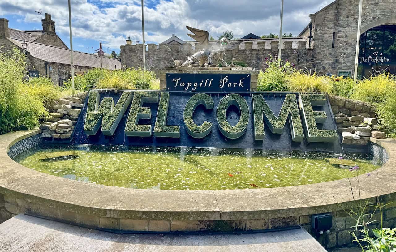
I stand back a little to admire the scene in full. This striking welcome sign sits in a small circular garden at the centre of a roundabout near the entrance to The Forbidden Corner. Surrounded by colourful planting and neat stonework, the water feature spells out ‘WELCOME’ in bold green letters, each one filled with foliage and framed by flowing water. Behind the sign, the arched stone building with its castellated wall and prominent clock tower marks one of the main entrances to The Forbidden Corner. The clock is set into a small turret with a domed roof, giving the structure the look of a miniature gatehouse or folly. Beneath the archway, I glimpse the main path into the attraction, drawing visitors towards the curious world beyond.
Lake District High Level and Fell Walks with Thirty Routes
AD This pocket-sized guide presents 30 routes on the Lake District’s highest fells, including Scafell Pike, Helvellyn, and Blencathra. With OS maps, colour photographs, and practical notes, it offers circular walks from 4–15 miles graded by difficulty.
With the entrance to The Forbidden Corner directly ahead, I turn right and join the bridleway that skirts the edge of the attraction. The path leads me gently uphill, threading through the grounds of Ashgill, and soon I find myself leaving the boundaries of Tupgill Park behind. From here, the route begins to feel more rural again, swapping landscaped gardens for rugged open countryside and quiet lanes.
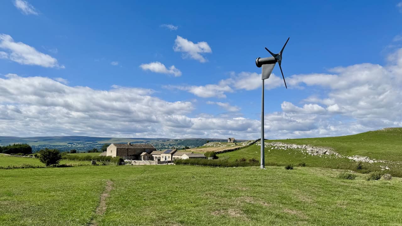
Leaving the park behind and following a route past Spigot Lodge, I find myself crossing a broad, open field. A small wind turbine turns lazily in the breeze, its slender form standing out against the wide blue sky. Ahead are the stone buildings of a beautifully maintained farm—perhaps holiday lets—set among limestone outcrops, with distant moorland rising behind them. The view stretches far across the dale. On top of a hill is a building I’ve seen many times from the other side of the valley. On the map, it’s called The Mount Tower, but there’s no public right of way leading to it and it’s not on open access land, so I give it a miss.

Super Sparrow Stainless Steel Insulated Water Bottle with Two Lids
AD The Super Sparrow stainless steel water bottle keeps drinks cold for 12 hours or hot for several. With a straw lid, bamboo cap, BPA-free construction, and durable 18/8 steel, it is ideal for sport, travel, work, and outdoor use.
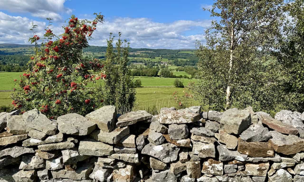
I follow a public footpath across several gently sloping fields in the direction of West Witton. Pausing by a dry stone wall, I peer over and take in the peaceful view stretching across Wensleydale. Among the patchwork of green meadows and scattered woodland, Bolton Hall stands out, tucked neatly into the landscape below. With clusters of red berries in the foreground and rolling hills beyond, it’s a classic Dales scene that captures the charm of this part of the valley.
I reach the main road in West Witton and pause to take in one of the finest views of the day. Looking north across the valley floor, I can see the village of Preston-under-Scar nestled at the foot of the hills, framed by fields, dry stone walls, and a solitary stone barn with a rust-red roof. A well-positioned bench on a quiet grassy rise offers a peaceful spot to stop and reflect before I continue my journey west through the village.
Super Sparrow Stainless Steel Insulated Water Bottle with Two Lids
AD The Super Sparrow stainless steel water bottle keeps drinks cold for 12 hours or hot for several. With a straw lid, bamboo cap, BPA-free construction, and durable 18/8 steel, it is ideal for sport, travel, work, and outdoor use.
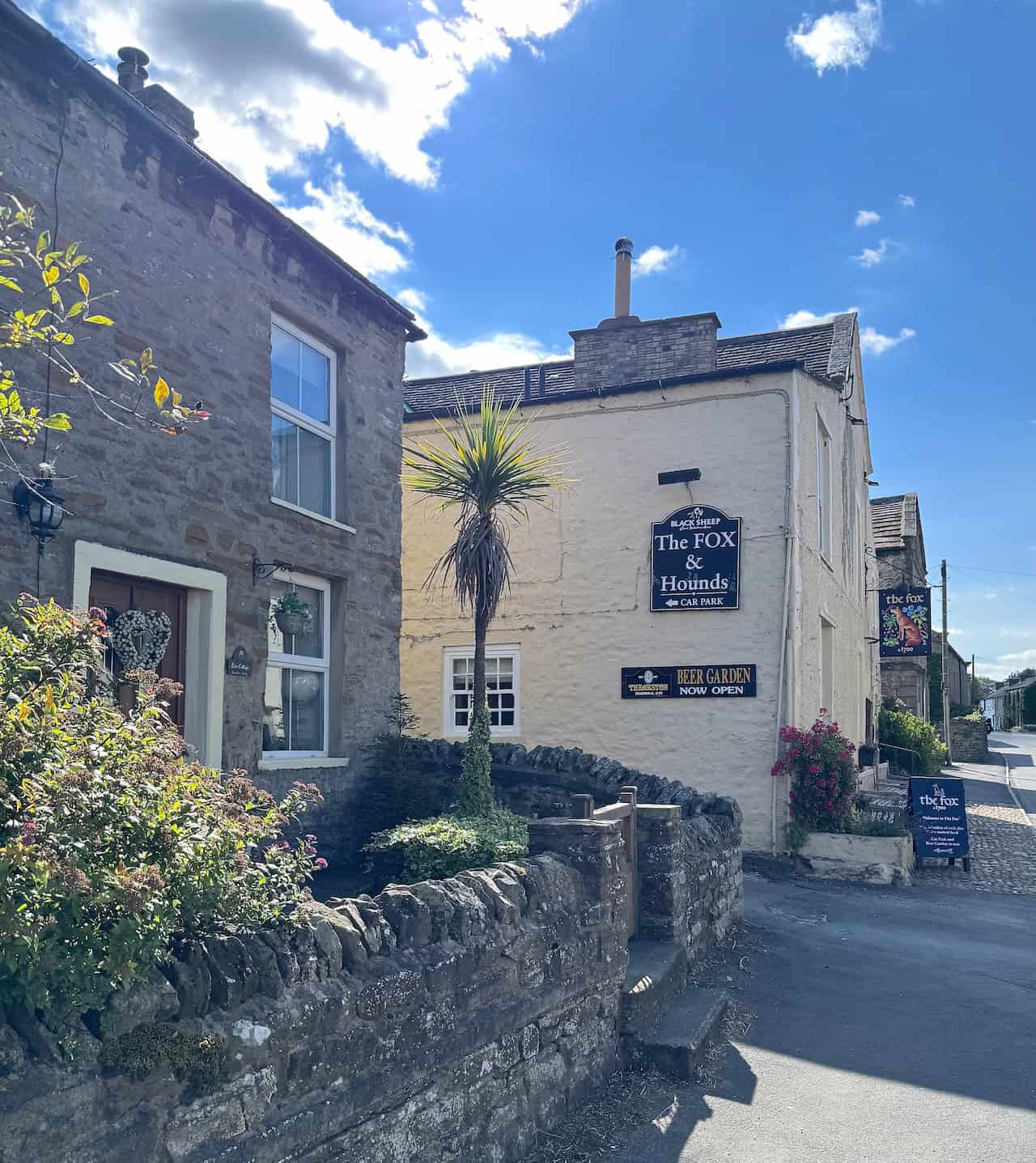
I continue west along the main road through the centre of West Witton, passing pretty cottages and well-kept gardens. Reaching the Fox & Hounds, a traditional Dales inn, I turn right and head towards the village church.
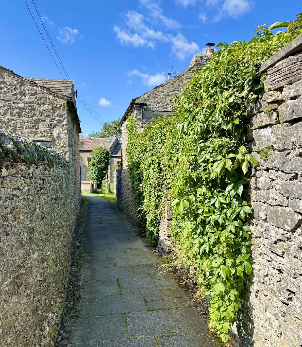
I follow a short, narrow passageway enclosed by old stone walls on either side, one of them thick with trailing ivy. The path is neatly paved and leads gently ahead, drawing me between the back walls of cottages towards the open green space around the church.

Mountain Warehouse Merino Womens Long Sleeve V Neck Top
AD This Mountain Warehouse Merino top combines warmth, comfort, and practicality. Made with high-quality wool, it is naturally antibacterial, lightweight, and easy to pack. Designed for outdoor activities, it keeps you fresh and warm, and comes with a two-year warranty.
I approach St Bartholomew’s Church, a peaceful and well-kept parish church in the heart of West Witton. Its tower dates from the 13th century and is the only surviving part of the original medieval structure. The rest of the church was rebuilt in 1875, during a major restoration carried out by the Bolton estate. The current building was designed by the Yorkshire architects Bownas and Atkinson and opened later that year with a service led by the Bishop of Ripon. It’s a modest and charming village church, beautifully set within its grassy churchyard.
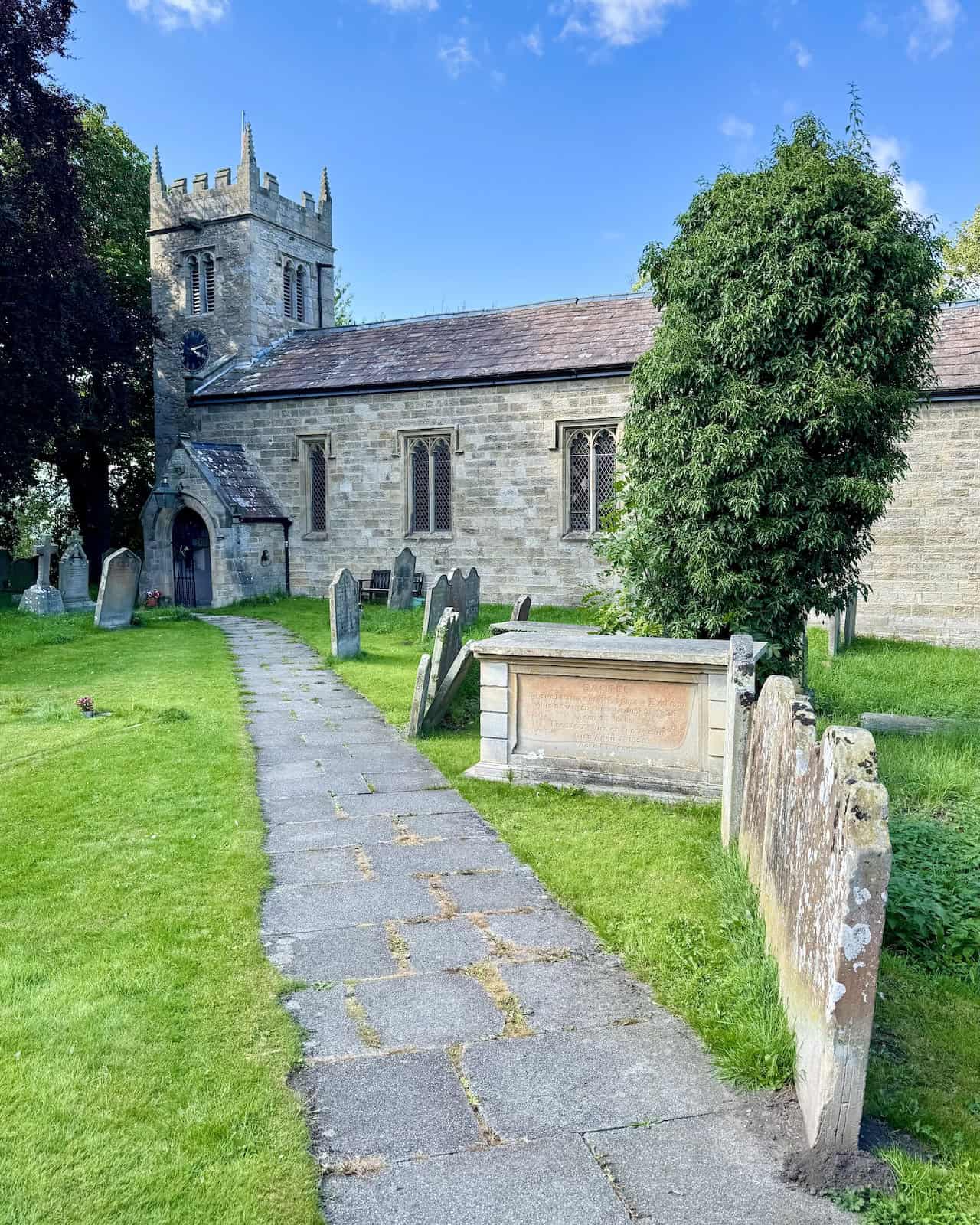
St Bartholomew’s Church remains active today and serves as part of a wider parish that includes nearby churches in Aysgarth, Redmire, Preston-under-Scar, Wensley, and Castle Bolton. St Bartholomew’s also has a small claim to fame—it featured in the original All Creatures Great & Small television series, in an episode titled ‘Cats & Dogs’. It’s a quiet, contemplative place with a sense of history, and a lovely spot to pause before continuing the Tupgill Park walk.
Mountain Warehouse Merino Womens Long Sleeve V Neck Top
AD This Mountain Warehouse Merino top combines warmth, comfort, and practicality. Made with high-quality wool, it is naturally antibacterial, lightweight, and easy to pack. Designed for outdoor activities, it keeps you fresh and warm, and comes with a two-year warranty.
From the church, I pick up a track known as Flats Lane and begin heading north across open fields. The track descends gently between grassy slopes, with hedgerows and scattered trees lining the way. In the distance, across the valley, I can see the village of Preston-under-Scar perched on the hillside, its stone buildings blending into the surrounding landscape. It’s a peaceful and inviting stretch as I make my way towards High Wanlass.
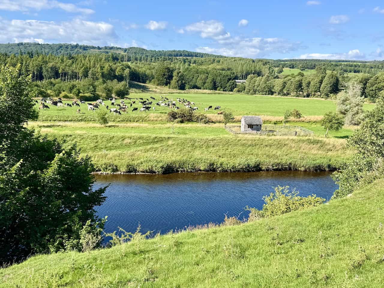
After passing through the farms at High and Low Wanlass, I follow a series of field paths that guide me gently downhill towards the River Ure. The descent brings with it a wide-open view of the valley floor, with the river glinting in the afternoon sun as it winds its way through lush green meadows. On the far bank, a large herd of cattle grazes contentedly near a small wooden shed, backed by a belt of woodland rising towards the hills beyond.
The Coast to Coast Walk Map Booklet with OS Mapping
AD This handy map booklet covers the full 188-mile Coast to Coast route from St Bees to Robin Hood’s Bay. Featuring 1:25,000 OS maps, it is pocket-sized, practical, and designed for use in either direction across England’s landscapes.
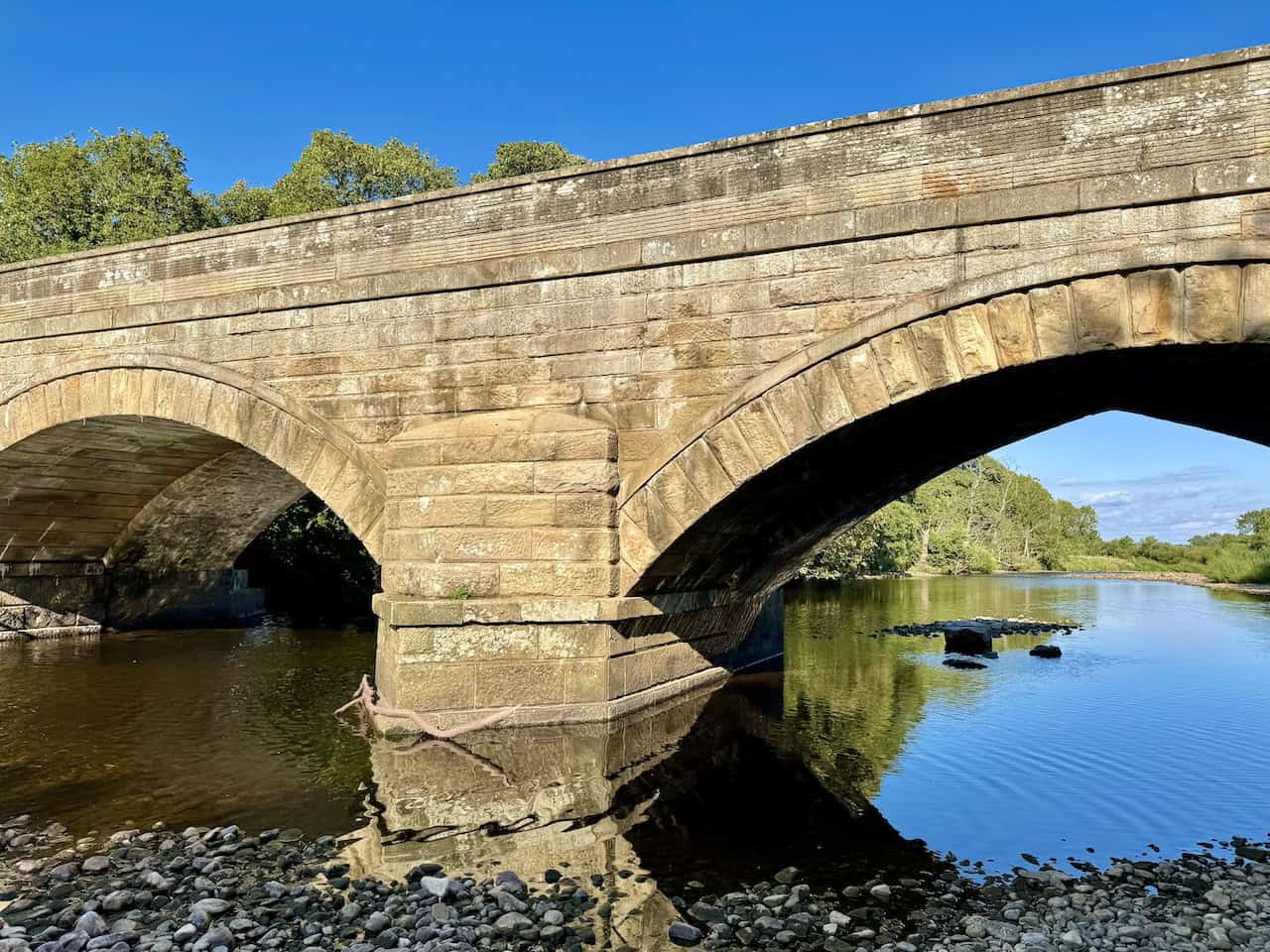
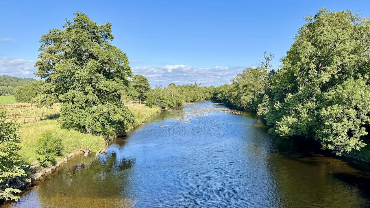
Shortly after reaching the River Ure, I arrive at Lords Bridge, a handsome stone structure that spans the water with quiet authority. Each end of the bridge is marked by a pair of square stone posts topped with rounded finials—two to the north and two to the south. Although my route doesn’t cross the river here, I stop for a moment on the bridge to enjoy the view northwards. The gravel track stretches ahead through open pastureland, leading directly to the grand façade of Bolton Hall, nestled among trees beneath the distant slopes.
Looking east from Lords Bridge, the River Ure winds gently through the Wensleydale landscape, its surface catching the light in ripples and sparkles. Flanked by thick woodland and open riverside meadows, the scene is peaceful and expansive, with trees leaning in from both banks and a scattering of pale rocks breaking the surface downstream. It’s a lovely spot to pause and take in the quiet rhythm of the valley.
The Coast to Coast Walk Map Booklet with OS Mapping
AD This handy map booklet covers the full 188-mile Coast to Coast route from St Bees to Robin Hood’s Bay. Featuring 1:25,000 OS maps, it is pocket-sized, practical, and designed for use in either direction across England’s landscapes.
From Lords Bridge, I begin the final stretch of my Tupgill Park walk, heading east along this peaceful riverside path. The narrow trail winds gently through lush undergrowth, with tall trees arching overhead and the River Ure flowing steadily alongside. Dappled sunlight flickers through the leaves, and the calm rustle of the woodland gives this section of the walk a quiet, secluded feel.
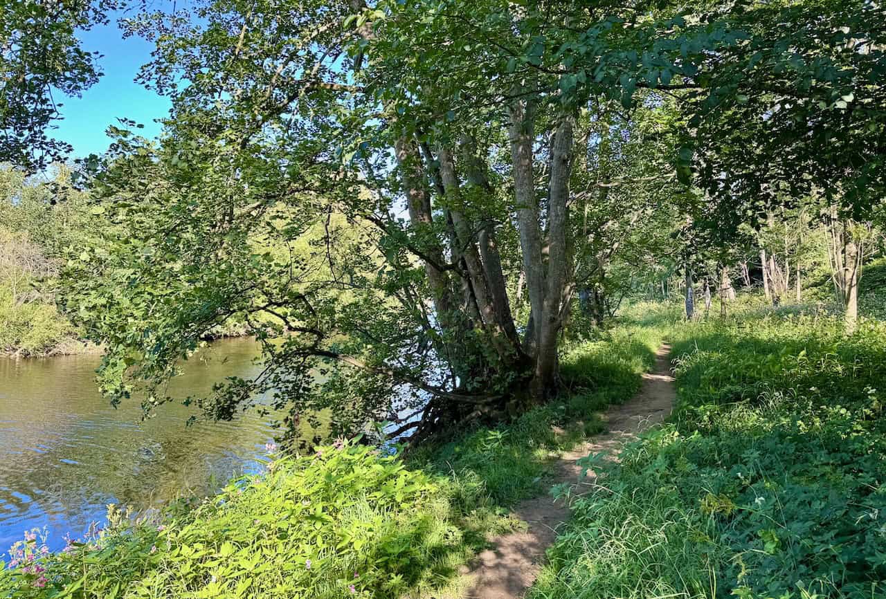
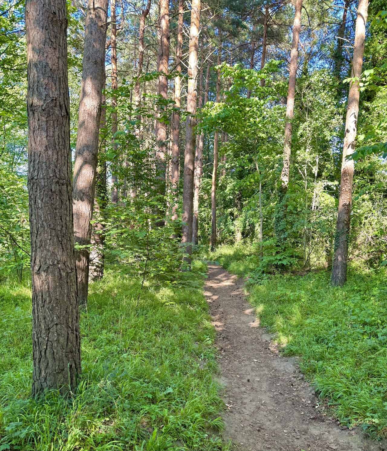
This stretch by the side of the River Ure is truly lovely. Just after leaving Lords Bridge, the path is slightly overgrown in places, with brambles and nettles brushing against my legs. But after a short while, the trail opens out and becomes much more pleasant, winding through tall pine trees and soft undergrowth. With the river still close by and dappled sunlight breaking through the canopy, it’s a peaceful and inviting part of the walk.
Walking the Wainwrights with Routes Covering Every Lake District Fell
AD This book includes 64 carefully designed routes that allow walkers to complete all 214 Wainwright fells. Intended to complement the original Pictorial Guides, it provides full-day circular walks that link multiple summits for a rewarding and practical challenge.
I arrive back at Wensley Bridge to conclude my Tupgill Park walk. The low afternoon sun casts a golden glow across the old stonework, lighting up the arches beautifully. Reflections shimmer in the River Ure below, and the peaceful riverside setting provides a perfect end to this varied and rewarding route through Wensleydale.