ADVERTISEMENT
A Rewarding Wensleydale Walk Featuring Redmire Force and Aysgarth Falls
Begin your Wensleydale walk in the picturesque village of West Witton, located in North Yorkshire along the A684, around four miles (6.4 kilometres) west of Leyburn. You’ll find a spacious roadside car park on the eastern edge of the village, just off the main road. From here, walk along the grassy verge back towards the centre of the village. As you approach, you’ll pass a large cream-coloured house on your left.
Continue walking into West Witton, passing a series of stone cottages and a bus stop, both on your left-hand side. Opposite Fold Cottage, turn right down a tarmac lane that slopes gently downhill. Ignore the public footpath branching off to your right and continue along the lane, which takes you past the entrance to West Witton Farm. Stay on this route, called Flats Lane, as it winds its way downhill for about half a mile (800 metres), eventually arriving at a farm at High Wanlass.
Once you reach the farmyard, turn left and follow a track through a gate, entering a field which is part of Wanlass Park. Head diagonally across the field, keeping a solitary oak tree on your right, until you reach a gap in the dry stone wall. Here, your Wensleydale walk joins a public footpath. Continue diagonally across the next field, descending towards the River Ure.
At the riverbank, turn left and follow the signposted public footpath towards Aysgarth. This stretch takes you alongside the river for approximately three quarters of a mile (1.2 kilometres), often with a dry stone wall and the River Ure running to your right. Eventually, you’ll enter Cornlands Wood and arrive at Redmire Force, a beautiful series of waterfalls hidden in a wooded glade.

ADVERTISEMENT
Wander through Cornlands Wood to explore the falls, then climb the steps out of the woodland and return to open countryside. Continue following the field edges, again with the dry stone wall and woodland to your right. After crossing several more fields, drop into a small wooded area where you’ll find the stepping stones across the River Ure. Pass the stones on your right and keep following the riverside path ahead.
You’ll soon pass through another patch of woodland at Adam Bottoms before reaching the A684. Turn right and cross Hestholme Bridge. On the other side, turn right again onto a public footpath that cuts across a field. Be careful not to follow the track leading to Hestholme Farm. Keep to the footpath as it crosses the field diagonally towards the River Ure, then pass a set of waterfalls on your right.
Carry on along the riverside trail and enjoy the views of Lower Force, part of the Aysgarth Falls series. You can choose either the lower or higher path here; the lower route offers better views of the falls, but make sure to rejoin the main footpath afterwards. Your Wensleydale walk now takes you through another wooded section, eventually emerging at St Andrew’s Church in Aysgarth.
In front of the church entrance, take the path to the left and follow it uphill to reach the A684 once more. Cross the road and join the footpath directly opposite, which is signposted to Eshington Bridge. Follow the trail across the fields, heading downhill. Stay on the main footpath, avoiding any turns, and continue across several fields until you reach the stone-built Eshington Bridge.
Cross the bridge, walk a short distance along the road, then take a right-hand turn following the public footpath signposted to West Burton. This route takes you across fields to a stream before turning left across more fields to arrive at the northern edge of West Burton. Cross the main road and climb the steps directly ahead into the village. Turn right to reach the village green, then left to walk downhill towards the bottom of the village. Here, turn right at the sign for the waterfall.

ADVERTISEMENT
At the waterfall, turn left and cross the stone packhorse footbridge over Walden Beck. Climb the steps that lead up the side of the valley and continue on the footpath signposted to Morpeth Scar via Barrick Wood. Once you reach the woodland edge, take the left-hand path marked for Morpeth Lane. Follow this along the woodland boundary until you arrive at a stone track. Turn right and continue until the track curves right. At this bend, take the left-hand footpath signposted to Temple Farm.
This section of your Wensleydale walk guides you along the edges of several fields for over a mile (1.6 kilometres), eventually bringing you to Temple Farm. When you exit the final field, you’ll see large barns in front of you. Turn right here and follow the track uphill into the woodland. This stone path rises diagonally through the trees. At the top, walk straight ahead, following the public footpath towards Nossill Lane via Langthwaite Lane, passing the ruins of the Knights Templars on your left.
Climb the grassy bank ahead until you reach a concrete lane. Turn right and follow it uphill. About halfway up, leave the concrete track by turning left at the signpost to West Witton via Nossill Lane. A short distance on, turn left again onto a public footpath that crosses open fields. This eventually leads you to Langthwaite Lane, an enclosed track bordered by dry stone walls.
Follow Langthwaite Lane for around three quarters of a mile (1.2 kilometres) until you meet a minor road called Chantry Bank. Turn left and head downhill to reach the western edge of West Witton. Finally, turn right and stroll through the village to return to the car park, bringing your Wensleydale walk to a rewarding close.
Wensleydale Walk: Maps and Tools
Visit either the OS Maps website or the Outdooractive website to view this walking route in greater detail. Both platforms offer a range of features, including the ability to print the route, download it to your device, and export the route as a GPX file. You can also watch a 3D fly-over and share the route on social media. Additionally, this page includes a printable version of the walk in PDF format. Plus there is a supporting video, available for you to watch on YouTube.
Wensleydale Walk: Distance, Duration, Statistics
Distance: 10½ miles
Distance: 16¾ kilometres
Duration: 5 hours
Ascent: 1108 feet
Ascent: 338 metres
Type: Circular walk

ADVERTISEMENT
Recommended Ordnance Survey Map
The best map to use on this walk is the Ordnance Survey map of the Yorkshire Dales Northern & Central Area, reference OS Explorer OL30, scale 1:25,000. It clearly displays footpaths, rights of way, open access land and vegetation on the ground, making it ideal for walking, running and hiking. The map can be purchased from Amazon in either a standard, paper version or a weatherproof, laminated version, as shown below.
Standard Version
Yorkshire Dales Walking Guidebooks
Walking in the Yorkshire Dales: North and East, by Dennis Kelsall, describes 43 circular day walks of 3 to 12 miles across the Howgills, Mallerstang, Swaledale, Wensleydale, Coverdale and Nidderdale, with Ordnance Survey mapping and notes on parking and refreshments.
15 Short Walks in the Yorkshire Dales, by Jonathan and Lesley Williams, covers the area around Sedbergh, Kirkby Lonsdale and Ingleton. Its 15 routes of 1 to 7 miles each take under three hours, ideal for families or a relaxed half day out. Both books can be purchased from Amazon, as shown below.
Walking the Yorkshire Dales
About Wensleydale
Nestled in the heart of North Yorkshire, Wensleydale is one of the most picturesque of the Yorkshire Dales. It takes its name from the village of Wensley, which once held the role of the valley’s market centre. The River Ure winds its way through the dale, and because of this, the area is sometimes referred to by its older name, Yoredale. While most of Wensleydale lies within the Yorkshire Dales National Park, its lower stretch beyond East Witton forms part of the Nidderdale Area of Outstanding Natural Beauty.
In the upper reaches of the dale, the distinctive rise of Addlebrough reaches 481 metres (1578 feet), while the lower end is marked by Penhill, standing at 526 metres (1726 feet). The surrounding geology, particularly the Yoredale Group of Carboniferous rocks, owes its name to the area. Wensleydale is perhaps most widely recognised for its famous cheese, made in Hawes—a charming town at the head of the valley.
Landscape and Layout of Wensleydale
Stretching around 25 miles (40 kilometres) from west to east, Wensleydale lies between two other notable dales—Wharfedale to the south and Swaledale to the north, with the scenic Buttertubs Pass offering a direct route between them. Smaller side valleys branch off in both directions: Cotterdale, Fossdale and Apedale lie to the north; to the south, you’ll find Widdale, Sleddale, Raydale, Bishopdale, Waldendale and Coverdale.
The River Ure flows steadily eastward, eventually transforming into the River Ouse and joining the Humber Estuary on its way to the North Sea. Along its course, the river is fed by several tributaries, including the Swale, Nidd, Wharfe, Aire, Derwent, and Trent. Taking a walk through Wensleydale brings spectacular views of the riverbanks and the rolling landscape around them.
A Glimpse into Wensleydale’s Past
Wensley appears in the Domesday Book of 1086, where it is described as having two berewicks—parcels of farmland—adding up to seven carucates. These lands belonged to Count Alan’s manor at East Witton and supported 11 villagers, 2 smallholders, and 18 ploughlands. By the close of the 12th century, the church in Wensley had been established, thanks to the patronage of Niel son of Alexander.
In 1202, Wensley was granted a Royal Charter, allowing it to hold a market and affirming its role as the valley’s main settlement. The influential Metcalfe family made Wensleydale their home after relocating from Dentdale in the 1300s. Sir James Metcalfe (1389–1472) fought alongside Henry V at the Battle of Agincourt, and his son, Sir Thomas Metcalfe, was responsible for building the fortified Nappa Hall near Askrigg.
During the 1500s and 1600s, the dale saw a rise in industry, particularly in lead and coal mining, as well as lime production. However, tragedy struck in 1563 when plague devastated the village of Wensley, prompting many survivors to settle in Leyburn. Over time, Leyburn replaced Wensley as the market town.
Wensleydale’s Changing Times
The arrival of the railway in 1846 marked a turning point for Wensleydale, linking it to wider trade routes. The line, initially connecting Northallerton to Bedale, later extended to include Leyburn, Hawes, and Garsdale. Wensley station opened in 1877 and became an important stop for communities throughout the valley.
Today, Hawes and Leyburn are Wensleydale’s principal towns, supported by a scattering of picturesque villages such as Aysgarth, Bainbridge, and Middleham. Bainbridge, in particular, is notable for being the point where the River Bain—the shortest river in England—flows from Semerwater to meet the Ure. Visitors can also explore the remains of a Roman fort and follow a walkable Roman road nearby.
Just outside of Hawes lies Hardraw Force, the tallest single-drop waterfall in England, tucked away behind the historic Green Dragon Inn. The area is rich with other natural wonders, including Aysgarth Falls—a stunning trio of waterfalls that famously featured in Robin Hood: Prince of Thieves and the 1992 adaptation of Wuthering Heights. Other scenic spots include Harmby Falls near Wensley, West Burton Falls, and the dramatic Whitfield Gill Force near Askrigg.
Wensleydale Walk: My Photos
I begin my Wensleydale walk in the village of West Witton. On the eastern edge of the village, a tarmac lane slopes gently downhill. This lane lies opposite Fold Cottage and the footpath that leads towards Capple Bank.

ADVERTISEMENT
The lane leaving West Witton is a delightful country track, enclosed on both sides by neat hedgerows. Known as Flats Lane, it runs northwards down to a spot called High Wanlass.

At High Wanlass Farm, I take a left off Flats Lane and walk across a broad grassy field, part of Wanlass Park. The footpath passes by a striking solitary oak tree, and I angle diagonally across the field, looking for a gap in the dry stone wall. A public footpath sign here points the way down to the River Ure, another beautiful section of my Wensleydale walk.

ADVERTISEMENT
At the gap in the dry stone wall, I find the signpost for the public footpath and head diagonally across another open field. Ahead in the distance, Bolton Castle rises proudly on the hillside, commanding the view.

Soon, I reach the River Ure—the first true highlight of this Wensleydale walk. The sunshine lights up the landscape, and it feels like a perfect beginning to the day.

ADVERTISEMENT
Although the path sits slightly above the river, I can’t resist dropping down to the water’s edge. It’s such an inviting spot. The scattered boulders along the bank make the perfect place to sit and enjoy a cup of coffee from my flask. It’s a wonderful scene, peaceful and picturesque by the River Ure.

ADVERTISEMENT
Back on the path, I’m treated to a stunning view looking down at a point where the river bends sharply to the right. The rocky deposits here are typical of a river’s lower course as it meanders gently through the countryside.

I follow the footpath around the river’s bend, taking in the calm surroundings. This section of the Wensleydale walk is a real joy—so scenic and serene.

ADVERTISEMENT
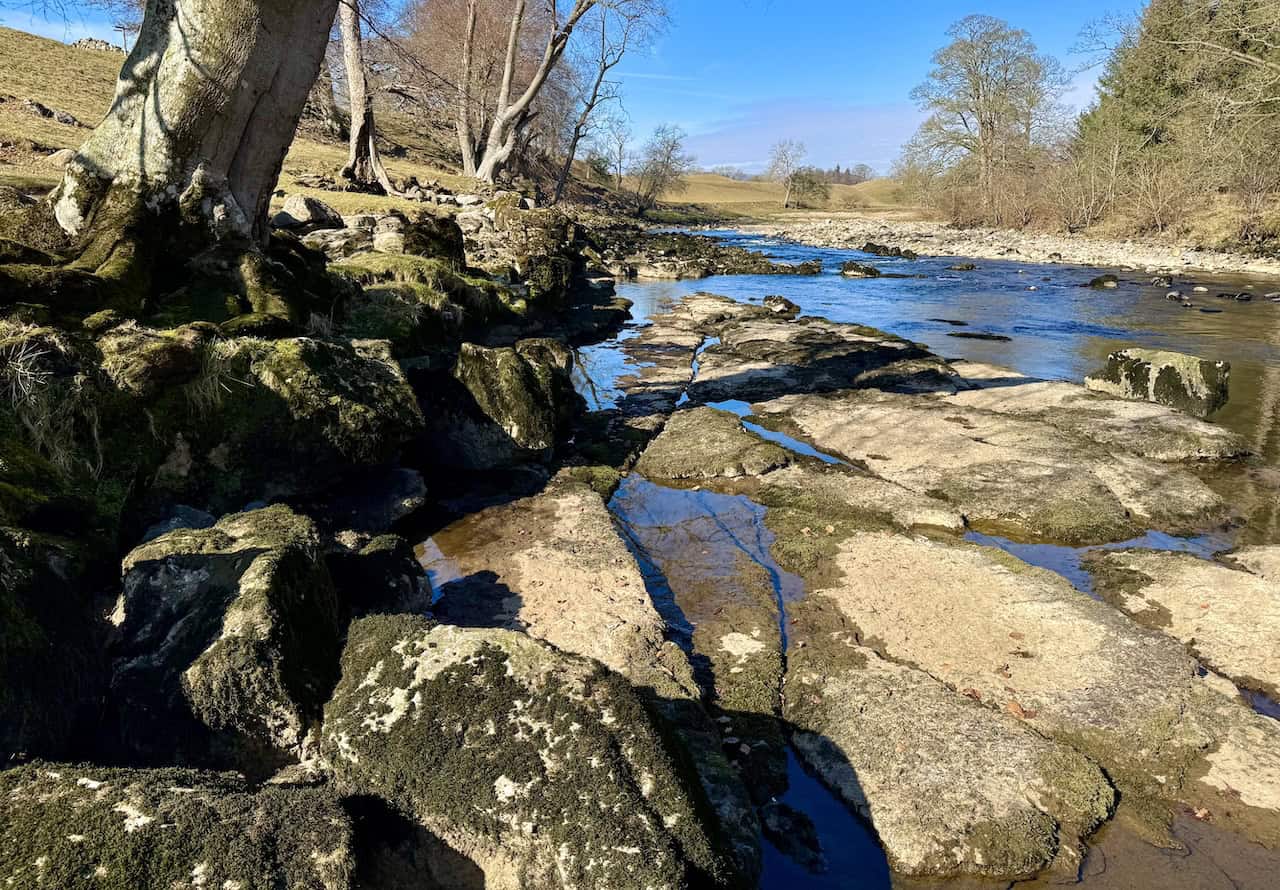
Eventually, the footpath brings me to Redmire Force, a series of small waterfalls on the River Ure. I’m standing on the southern side of the river, taking in the tranquil scene. The water flows gently over broad limestone steps, creating miniature cascades. I’ve visited Redmire Force before, but always from the village of Redmire on the northern bank. Seeing it from this side offers a fresh and rewarding perspective.

Leaving Redmire Force behind, I continue along the footpath. For quite some time, woodland and a dry stone wall line my right-hand side. The River Ure remains to the right as well, although it dips out of sight in the valley below.

After passing Middle Wood, the path opens up to spectacular views northwards. The River Ure winds its way below, and further on, Bolton Castle catches the light, standing proud on the hillside. To its right, I can see the rooftops of Castle Bolton village.

ADVERTISEMENT
Eventually, I reach the stepping stones across the River Ure. Although I’m not planning to cross today, the temptation proves too strong. I step out onto the stones and back again, revelling in the moment. I’ve been here before, and I know these stones can sometimes disappear completely when the river runs higher.


Standing on the stepping stones, I gaze upstream. The shallow, clear waters of the River Ure reflect the bright blue sky, creating an utterly peaceful scene.

ADVERTISEMENT
From Hestholme Bridge, I cross a field to reach another series of waterfalls on the River Ure. These are not to be confused with Lower Force (Aysgarth Falls), which I’ll reach shortly further upstream to the west. Here, the river widens, spilling over tiered limestone steps in graceful, rhythmic cascades. It’s a beautiful setting, perfect for sitting beside the water and enjoying the sound of the flowing river—and yes, it’s time for another coffee from my flask during this well-earned rest on my Wensleydale walk.


ADVERTISEMENT
Eventually, I arrive at Lower Force, part of the well-known Aysgarth Falls. The public footpath doesn’t go right down to the water, but there’s an excellent side path that allows for a brief detour—as long as I rejoin the main path a little further along. Aysgarth Falls actually comprises three separate waterfalls: High Force, Middle Force, and Lower Force, all on the River Ure. Of the three, Lower Force is the furthest downstream. I get very close to this one, where the water spills over in curtain-like sheets from one ledge to the next. The stepped nature of the waterfall is clearly visible, and although recent rainfall has been minimal, the water still moves with clarity and energy. At times, the river takes on a brownish-orange hue from the peat it carries down from the moors. As I continue upstream, I pass Middle Force, although the view is limited from the southern bank—perhaps that’s a route to explore another day.


ADVERTISEMENT

Continuing along the path, I approach the eastern side of St Andrew’s Church in Aysgarth. It’s an impressive sight. The warm, weathered stone and large Gothic-style windows, along with the crenellated parapets, make this a standout building. St Andrew’s is one of the largest churches in Wensleydale and is particularly known for its grand interior and the fittings that were salvaged from Jervaulx Abbey following the dissolution of the monasteries.

I follow the footpath in front of the church and, upon reaching the entrance, turn left and head up towards the A684.

From the main road, the path leads southwards across several grassy fields towards Eshington Bridge. Behind a beautiful old stone barn, the land stretches into a patchwork of green fields, with the hill known as Height of Hazely rising in the distance. At 553 metres (1814 feet), it dominates the background.

ADVERTISEMENT
I reach Eshington Bridge and cross over. This charming single-arched stone bridge dates back to 1888, as far as I can tell from the carved inscription. It spans Bishopdale Beck, another of the many delightful features on my Wensleydale walk.

After exploring the village of West Burton, I visit one of the highlights of this Wensleydale walk: the waterfall at West Burton. It’s just a short stroll from the village green. Before I even get to the waterfall, I’m greeted by a tranquil scene where an old packhorse stone bridge crosses Walden Beck. It’s a beautiful day, and people are gathered here, enjoying lunch in this peaceful corner of Wensleydale.


ADVERTISEMENT
I move in for a closer look at the waterfall, known both as West Burton Falls and Cauldron Falls. It’s a series of cascades on Walden Beck, a tributary of the River Ure. The name ‘Cauldron’ comes from the swirling plunge pool at the base of the falls. The beck flows beneath the stone packhorse bridge, where another cascade forms. The water travels over a shelving rock fault and plunges in two main stages. The first drop, known as Upper Cauldron Falls, descends 20 feet (6.1 metres) into a plunge pool, surrounded by a north-facing limestone amphitheatre. The lower section flows under a locally known stone bridge called Blue Bridge. The name ‘Cauldron Falls’ reflects the circular motion of the water in the plunge pool, shaped over time by glacial action rather than meltwater. J. M. W. Turner captured this very scene in a painting during his travels through Wensleydale in 1816.


After spending time by the falls, I cross the packhorse bridge and climb a stepped path that takes me up the far side of the valley, back into open countryside.

ADVERTISEMENT
The woodland footpath soon meets a track called Morpeth Gate. I leave the track behind and follow a flat, grassy path across open fields. The going is easy, and the views across Wensleydale are fantastic.

As I walk, I glance up to my right and spot the rocky outcrop known as Morpeth Scar.

After a long stretch across farmland, I reach the Penhill Preceptory, a key stop on this Wensleydale walk. This historic site, protected under the Ancient Monuments Acts, was established around 1200 by the Knights Templar. They used it as a base to manage their estates and support their activities in the region. When the Templars were suppressed in 1312, the site passed to the Knights Hospitaller, though it was considered unfit for use by 1328. Over the centuries, the buildings fell into ruin. The chapel’s remains were uncovered in 1840 and can still be explored today. The exposed foundations measure 17.5 metres (57 feet) by 6.8 metres (22 feet), and inside, three stone coffins and the base of the original altar are visible. While the living quarters have yet to be excavated, surrounding earthworks suggest their location. It’s a fascinating part of Wensleydale’s rich heritage.


ADVERTISEMENT
The return route to West Witton takes me along Langthwaite Lane, a lovely track bordered on both sides by traditional dry stone walls. It’s a charming way to end this part of the walk.

I rejoin the A684 on the western side of West Witton and turn right, heading back through the village.

As I walk through the village, I pass a delightful green with a small seating area. It’s the perfect place to pause and finish the last of my coffee.

Further along, I come to The Wensleydale Heifer. This 17th-century coaching inn has been transformed into a boutique hotel and seafood restaurant. For over two decades, Lewis and David Moss—father and son—have run this much-loved spot. With themed rooms such as ‘James Bond’, ‘Black Sheep’, and ‘All Creatures Great & Small’, it blends charm and luxury. The food and hospitality are consistently excellent, making it a favourite among both locals and walkers.

My Wensleydale walk concludes with a breathtaking view looking north across the valley floor. From here, I can see the village of Preston-under-Scar nestled into the landscape. It’s a perfect end to a thoroughly rewarding walk.

ADVERTISEMENT
ADVERTISEMENT