ADVERTISEMENT
Everything You Need to Know About the Ingleborough Walk from Clapham
Start your Ingleborough walk at the Yorkshire Dales National Park car park in the centre of Clapham village. This is a good pay-and-display car park with plenty of spaces, along with toilet facilities. If it is full, alternative parking is available elsewhere in the village centre.
Leave the car park and turn right onto the road, following the sign for the pedestrian route to Ingleborough Cave, the Ingleborough Estate Nature Trail, and The Old Sawmill Café. Immediately turn left and cross Clapham Beck via the old stone packhorse bridge. On the far side, turn right once more, keeping to the signposted pedestrian route to Ingleborough Cave. Walk north along the road, known as Riverside, passing a large Georgian-style house called Hall Garth and, shortly after, Yew Tree Cottages, both on your left-hand side.
Further along, you will pass a road bridge on your right-hand side. Do not cross it. Instead, continue straight ahead, signposted towards Ingleton and Dent. At the top of the road, you will reach the entrance to the Ingleborough Estate Nature Trail. Remain on the road as it bends left past The Old Sawmill Café. Walk a short distance, then turn right onto a stony track, waymarked as a public bridleway to Ingleborough Cave and a public footpath to Ingleborough and Gaping Gill.
Continue steadily along this straightforward track in a northerly direction for about a mile until you reach the farm at Clapdale. Walk through the farmyard, go through a gate, and turn right, following the footpath sign for Ingleborough Cave. Descend the grassy bank into the valley to meet the stone track known as Clapdale Drive. Turn left here and walk alongside Clapham Beck until you reach Ingleborough Cave.
Pass Ingleborough Cave on your left-hand side and cross another old stone packhorse bridge spanning Clapham Beck. Keep to the main track through the valley for about a third of a mile, after which it swings left towards Trow Gill. Climb uphill along the path through the steep-sided, narrow ravine of Trow Gill. The route you are following is part of A Pennine Journey.

ADVERTISEMENT
Follow the valley by the dry stone wall for over two-thirds of a mile. When the stony track ends, look for two small gates in the dry stone wall on your left-hand side. Pass through and follow the grassy path, still part of A Pennine Journey, passing a large pothole to your left.
Soon afterwards, the path forks. Take the right-hand fork for a short detour to visit Gaping Gill. After visiting Gaping Gill, find the narrow path that leads you back to the main track of A Pennine Journey.
Begin your three-quarters of a mile climb to the top of Little Ingleborough along a well-maintained path comprising gravel, stone steps, and large paving slabs. Although steep, the route is easy to follow. At Little Ingleborough, the path levels out for a while before you begin your final ascent of Ingleborough.
The path remains clear, heading towards the right-hand, or eastern, side of the mountain’s flat-topped plateau. Follow it until it veers right and starts to descend. Look to your left to spot two large stone cairns. Head towards them to pick up the path running along the northern edge of the mountain’s plateau.
Continue along this path to reach the seating area and the summit triangulation pillar of Ingleborough. From the seating area, retrace your steps towards the two cairns. Remember, you are veering slightly left, not walking directly across the middle of the plateau. To the left of the cairns, you will find the path leading off the north-east corner of the mountain.
Descend carefully down a series of large, stepped boulders, with a cluster of weathered grey rocks on your right-hand side. As you descend, the path becomes a flagged route of large stone slabs. It soon splits into two at a concrete post about three feet tall. Turn right here to start your descent via the Dales High Way. You are now roughly halfway through your Ingleborough walk.

ADVERTISEMENT
Follow the Dales High Way for just over 1½ miles. The terrain is mixed, with eroded rocky sections, stone steps, and large paving slabs, but the way remains clear. Eventually, you will pass a derelict stone shooting hut on your left-hand side. Shortly afterwards, reach a gate marked by a wooden signpost pointing towards Horton in Ribblesdale.
Almost immediately beyond the gate, the path forks again at Nick Pot. The fork is marked by a single wooden post with a yellow waymarker arrow. Do not turn left following the waymarker. Instead, turn right and join a comfortable grassy path heading south.
Continue through areas of limestone pavement for about a mile until you reach a T-junction with the Pennine Bridleway, marked by a single wooden post. Turn right and follow the bridleway towards a large, cone-shaped cairn visible on a distant hill.
After a few minutes, the grassy path splits. The split is marked by a wooden post bearing a bridleway waymarker and an acorn symbol. Take the left-hand path towards the large, cone-shaped cairn. Pass the cairn on your right-hand side and carry straight on, descending the hillside.
Follow the bridleway, waymarked with blue arrows, until a gate leads you onto a stone track known as Long Lane. Continue south along Long Lane for about 1½ miles until you reach a junction with Thwaite Lane.
Turn right, following the public bridleway signpost for Clapham. Descend gently for one-third of a mile, passing through the atmospheric Clapham tunnels. At the bottom, turn right, then immediately left to follow the road past the children’s playing fields on your right-hand side. Continue along the road until you reach the car park on the left-hand side, where your Ingleborough walk concludes.
Ingleborough Walk: Maps and Tools
Visit either the OS Maps website or the Outdooractive website to view this walking route in greater detail. Both platforms offer a range of features, including the ability to print the route, download it to your device, and export the route as a GPX file. You can also watch a 3D fly-over and share the route on social media. Additionally, this page includes a printable version of the walk in PDF format. Plus there is a supporting video, available for you to watch on YouTube.
Ingleborough Walk: Distance, Duration, Statistics
Distance: 10½ miles
Distance: 16½ kilometres
Duration: 5½ hours
Ascent: 2171 feet
Ascent: 662 metres
Type: Circular walk

ADVERTISEMENT
Recommended Ordnance Survey Map
The best map to use on this walk is the Ordnance Survey map of the Yorkshire Dales Southern & Western Area, reference OS Explorer OL2, scale 1:25,000. It clearly displays footpaths, rights of way, open access land and vegetation on the ground, making it ideal for walking, running and hiking. The map can be purchased from Amazon in either a standard, paper version or a weatherproof, laminated version, as shown below.
Standard Version
Yorkshire Dales Walking Guidebooks
Walking in the Yorkshire Dales: South and West, by Jan and Dennis Kelsall, describes 44 circular day walks of 3.5 to 13 miles across Wharfedale, Littondale, Malhamdale, Dentdale and Ribblesdale, plus the Yorkshire Three Peaks Challenge, with Ordnance Survey mapping and notes on parking and refreshments.
Short Walks Yorkshire Dales, by Rachel Crolla and Carl McKeating, covers the area around Grassington, Skipton, Malham and Ilkley. Its 15 routes of 2.5 to 6 miles each take under three hours, ideal for families or a relaxed half day out. Both books can be purchased from Amazon, as shown below.
Walking the Yorkshire Dales
About Ingleborough
Ingleborough, at 724 metres (2375 feet), is the second-highest mountain in the Yorkshire Dales National Park. It is one of the Yorkshire Three Peaks, along with Whernside and Pen-y-ghent, and is climbed as part of the popular Yorkshire Three Peaks Challenge. Much of Ingleborough is designated as a Site of Special Scientific Interest and a National Nature Reserve. It is also home to a project called Wild Ingleborough, which brings together several organisations to improve the landscape for wildlife and people.
Yorkshire Three Peaks: Watch the Flyover Videos on YouTube
Pen-y-ghent Flyover | Whernside Flyover | Ingleborough Flyover
The first part of the name ‘Ingleborough’ has been explained in different ways. Some believe it comes from a Scots word meaning ‘beacon’ or ‘fire’, an Old Danish term meaning ‘English’, or a word from Old English ing, meaning ‘peak’. The second part comes from the Old English word burh, meaning ‘a fortified place’, in this case referring to a hill fort. The summit plateau of Ingleborough is still surrounded by the remains of a massive stone rampart, containing the foundations of Iron Age huts.
Ingleborough’s striking appearance from all directions, and from many miles away, is due to the unusual geology of its rocks. The mountain’s base is made up of ancient Silurian and Ordovician rocks, which can be seen in the valleys to the north of Ingleton. Above this lies a thick layer of Carboniferous Limestone known as the ‘Great Scar Limestone’, about 180 metres (600 feet) deep. Because limestone is porous, streams flowing down the mountain disappear underground, falling into potholes when they reach the limestone. Above the limestone sits the Yoredale Series of sedimentary rocks, mostly shale and sandstone, usually hidden by peat but exposed in the cliffs about 520 metres (1700 feet) up. Layers of harder limestone are sandwiched between softer rocks. These harder layers have resisted erosion and helped protect the ones below, giving the mountain its ‘tiered’ appearance. However, the whole mountain is ultimately protected by a cap of Millstone Grit, about 30 metres (100 feet) thick. The rock that once lay above the grit has been worn away over time, which explains why the summit is relatively flat.
Ingleborough Walk: My Photos
After parking in the Yorkshire Dales National Park car park in Clapham, I cross Clapham Beck via a charming stone footbridge. The footbridge sits almost directly opposite the car park. The sun is out, and it looks as though the weather forecast for my Ingleborough walk is going to be perfect.

ADVERTISEMENT
The footbridge over Clapham Beck is a traditional single-arched stone packhorse bridge with low parapets. It looks as though it has stood here for centuries. The water is crystal clear, and it creates a picturesque scene right in the heart of the village.

I turn right after the packhorse bridge and make my way along the road called Riverside, passing the magnificent Hall Garth on my left-hand side. It is a striking Georgian-style house with pale stone walls and sash windows. It must be very grand inside, I think.

ADVERTISEMENT
Continuing further along Riverside, I pass Yew Tree Cottages on my left and another bridge across Clapham Beck on my right. This is a road bridge and leads to the church, but I do not cross it, instead continuing straight forward. I will visit the church on my return to the village at the end of my Ingleborough walk.
Just a little further along the road, I reach a viewpoint where I can see Clapham Falls. I have been here before, and I must admit I have seen the falls flowing far more forcefully through the archway. Today, it is just a gentle trickle from a hole at the bottom of the waterfall. At the viewpoint, an interpretation board explains a little about Clapham Falls. They were constructed in 1837 by Oliver and James William Farrer as part of the remodelling of the land around Ingleborough Hall, the newly enlarged home of the Farrer family. Consisting of three separate tiers, of which only one is visible from the village, the falls are fed from a lake easily reached via a short walk up the Ingleborough Estate Nature Trail. During the Second World War, Captain John Farrer’s school was evacuated from Kent to Ingleborough Hall. The school had a small rowing boat kept in the boathouse in the corner of the lake. Young Bill Farrer, a pupil, took this boat out one stormy day when the water was in spate and was swept over the falls. Hanging on for dear life, he was carried down all three tiers, ending up below the church with bruised pride and a broken arm.

ADVERTISEMENT
I continue walking along Riverside to reach the entrance to the Ingleborough Estate Nature Trail, where the road swings to the left, passing by The Old Sawmill Café. The Old Sawmill in Clapham has historical roots stretching back to the 12th century, when a corn mill and fulling mill were known to exist in the village. The first confirmed evidence of a building here appears on the 1851 Tithe Map and the first Ordnance Survey map of the same year, showing a structure that matches the oldest part of the current sawmill. By 1896, the building had been extended to match the footprint seen today. In more recent times, the ground floor was used to store tools and equipment for the rural estate, while the upper floor served as a joinery workshop. As a listed building, The Old Sawmill’s renovation was carried out with great care under the guidance of the Yorkshire Dales National Park Authority. Original features such as bench saws and a water turbine were preserved, and artefacts recovered during the renovation, including a pick carved with the initials of Reginald John Farrer, are now displayed for visitors.

Leaving the village behind, I make my way north along the bridleway towards Clapdale. This early stretch of my Ingleborough walk is full of charm. Peering over the dry-stone wall, there is a delightful scene of lambs playing amongst a large pile of stone tree trunks and logs scattered across a grassy hillside. It looks like a playground for the sheep.

ADVERTISEMENT
I continue along the bridleway, which rises and then follows the contours above Clapdale Wood and across the elevated western slopes above the Clapham Beck valley. I reach the farm at Clapdale, where the bridleway takes me through the farm and then it is a right turn to drop down into the valley.

I drop down into the valley and continue my Ingleborough walk by following the track, called Clapdale Drive, alongside Clapham Beck, in the direction of Ingleborough Cave.

ADVERTISEMENT
I reach Clapham Beck Bridge, often simply called the Little Bridge, near the entrance to Ingleborough Cave. It carries the track over Clapham Beck. The bridge is a classic example of traditional Yorkshire Dales stonework: a sturdy, single-arched structure built from rough limestone blocks, blending naturally with the rocky landscape around it.

Clapham Beck Bridge’s age is not precisely documented, but it is generally believed to date back to the 18th or early 19th century, originally built to serve the local estate and its farms. Its simple, rugged construction perfectly suits the surrounding landscape. Over time, moss and lichen have taken hold between the stones, giving it a wonderfully aged and timeless character.

Ingleborough Cave was discovered on 23rd September 1837, when James Farrer, with the help of a group of intrepid estate workers, broke down the limestone dam that lay within. With no certainty of what lay beyond, this was an extraordinarily daring and dangerous mission. The underground lake was drained, allowing exploration of what is today the show cave.

ADVERTISEMENT
James Farrer, aware of the significance of his discovery of Ingleborough Cave, made the cave accessible to the public by building paths and bridges so that even Victorian ladies could venture within. Since those early days, visitors have continued to explore this remarkable natural wonder, first using candles, then oil and Tilley lamps, and today, electric lighting.

Crossing over Clapham Beck Bridge, I look to my left over the bridge’s low parapet to see Clapham Beck emerging from its underground journey. Clapham Beck is part of an extensive underground water system. Its journey begins on the slopes of Ingleborough, where streams like Fell Beck gather and flow across the limestone landscape. Fell Beck is particularly notable for its dramatic descent into Gaping Gill, a vast pothole where the water plunges approximately 110 metres, forming the tallest unbroken waterfall in the UK. After disappearing into Gaping Gill, the water travels through a complex network of subterranean passages. This underground journey was confirmed in 1983 by cave divers and earlier through dye tracing experiments. Eventually, the water resurfaces here at Clapham Beck Head, adjacent to Ingleborough Cave.
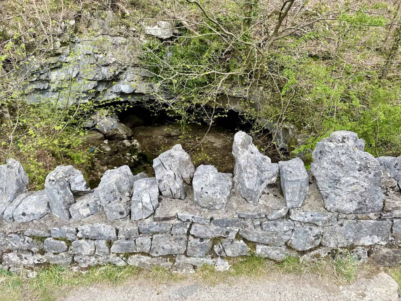
From Ingleborough Cave, I continue heading north through the limestone valley along a wonderfully atmospheric stretch of my Ingleborough walk. On either side, steep banks rise up, strewn with loose rocks and outcrops of bare limestone. Moss-covered dry-stone walls, some crumbling with age, line the way. A scattering of trees, their branches mostly bare or just beginning to leaf, cling stubbornly to the slopes, their twisted forms shaped by wind and weather.

ADVERTISEMENT
The track I am walking on forms part of a long-distance trail called A Pennine Journey. It bends around to the left and I get my first sight of the breathtaking Trow Gill. It is an absolute highlight of my Ingleborough walk.

This impressive Trow Gill gorge is thought to have been carved out by meltwater from the last ice age some 14,000 years ago, as the 400-metre-thick sheet of ice on Ingleborough gradually melted, forming this dramatic feature.

I climb the rocky path through the narrow limestone ravine, the sides towering vertically and spectacularly on either side. The cliffs are sheer and rugged, with jagged textures that show the powerful forces that shaped them long ago. Such a fascinating place.
ADVERTISEMENT
I continue following A Pennine Journey from Trow Gill. It is a rocky path but easy to follow, running beside a weathered and mossy dry-stone wall. The route becomes less steep as I begin to reach the top of the valley. I love the jagged limestone crags jutting out from the hillside, full of the timeless magic that makes walking in the Yorkshire Dales so special.

I reach the top of the valley and get my first sight of Little Ingleborough, which I need to climb in order to reach Ingleborough itself. The colours are stunning: the golden grasses, the grey limestone, and the beautiful sunlight catching the hillside of Little Ingleborough.

The area is strewn with potholes, typical of limestone countryside. I pass a particularly huge and dramatic example of a pothole caused by thousands of years of erosion. In the Yorkshire Dales, potholes like this are formed by a process called limestone dissolution. Rainwater absorbs carbon dioxide from the atmosphere and the soil, becoming slightly acidic. When this mildly acidic water seeps into cracks and joints in the limestone, it gradually dissolves the rock over thousands, even millions, of years. As the water continues to flow underground, it enlarges these cracks into tunnels, shafts, and caves. Where the roof of an underground passage becomes unstable or collapses, or where the water cuts down vertically along a joint, a pothole forms at the surface.

ADVERTISEMENT
Not much further along the track from the previous pothole, I reach Gaping Gill, one of the largest underground chambers in the United Kingdom. Here, Fell Beck, the stream flowing down from Ingleborough, suddenly disappears over the lip of the pothole and plunges almost 100 metres to the floor of the Main Chamber. The first recorded attempt to descend Gaping Gill took place in 1845, when John Birkbeck of Settle managed to reach a ledge about 55 metres down the shaft, now known as Birkbeck’s Ledge. However, it was not until 1895 that Gaping Gill was fully descended for the first time, when the French speleologist Édouard-Alfred Martel achieved the feat using a rope ladder and only a candle for illumination.

Exploration continued the following year, in 1896, when the Yorkshire Ramblers’ Club visited Gaping Gill. They lowered cavers into the Main Chamber via a pulley system and made significant discoveries, including Old East Passage and West Chamber. In 1908, the newly formed Yorkshire Speleological Association made further contributions, discovering South Passage and many other nearby passages, as well as identifying a new entrance into the system called Flood Exit Pot. Today, there are at least ten other known entrances into the Gaping Gill system. In 1983, after many years of exploration, teams from the Bradford Pothole Club and the Cave Diving Group successfully realised the long-held dream of connecting Gaping Gill to Ingleborough Cave. This challenging journey involved negotiating several miles of rough, tight passages and multiple underwater sumps within the limestone, requiring specialist equipment, skill, and expertise.

In 1995, to celebrate the centenary of Martel’s historic descent, members of the Bradford Pothole Club marked the occasion by descending Gaping Gill once again, dressed in period costume and using 100 metres of specially made rope ladder. More recently, a detailed 3D model of the Main Chamber has been produced using an industrial laser rangefinder, revealing that its volume is comparable in size to York Minster. Gaping Gill remains a truly awe-inspiring natural marvel, and its exploration stands as a testament to generations of determination, ingenuity, and adventure.

After the exhilarating experience at Gaping Gill, I start my climb up to Little Ingleborough. It is an easy path to follow and navigate, a well-maintained gravel path that transitions into rocky steps and sections with large stone paving slabs. However, it is steep and continues for about three-quarters of a mile, so I am soon puffing and panting.

ADVERTISEMENT
After reaching Little Ingleborough, the path levels out for a while and it is a welcome relief on my Ingleborough walk. However, I know there will be a further ascent to reach the summit of Ingleborough.

Ingleborough has a broad, flat plateau. The summit of the mountain can be accessed from several directions. My route comes from the south, from Little Ingleborough, and the path is well defined and easy to follow. It ascends towards the eastern edge of the expansive summit plateau.

As I follow the path along the eastern edge of Ingleborough’s broad, flat summit plateau, I can see to my right the route I will be taking later. It is the Dales High Way, which skirts the southern slopes of Simon Fell.

I continue along the eastern edge of Ingleborough, to the point where the path bends around to the right and starts to descend. Looking to my left, I spot the two large cairns that mark the course of the path leading to the summit. The path here is not immediately obvious. This part of the mountain top is walked over by tens of thousands of people each year taking part in the Yorkshire Three Peaks Challenge. My advice to those unfamiliar with this mountain is to spend a few moments getting to know the location of these two cairns, as they mark the approximate position of the descent path after visiting the summit trig point and seating area.

ADVERTISEMENT
From the two cairns, I now follow the path along the northern edge of the mountain’s broad, flat plateau, rather than walking directly across the middle of the mountain top. The reason is that I enjoy fantastic views of the valley that separates Ingleborough and Whernside. Whernside is visible on the other side of the valley, and it is this valley that participants of the Yorkshire Three Peaks Challenge cross to get from Whernside to Ingleborough. Also visible is the majestic Ribblehead Viaduct.

Also visible from the path along the northern edge of Ingleborough’s broad plateau is a stunning view of the area known as Humphrey Bottom. Walkers participating in the Yorkshire Three Peaks Challenge use the path across Humphrey Bottom before they start the very steep, renowned ascent of Ingleborough. There are also spectacular views of the steep slopes of Souther Scales Fell.

I reach the elaborate star-shaped seating area, located more towards the western side of Ingleborough’s flat plateau. Ingleborough is often very windy, and this seating area is a welcome refuge. Often, I have seen one or two sections of the seating area empty while the other sections are crowded with walkers, depending on the wind direction.

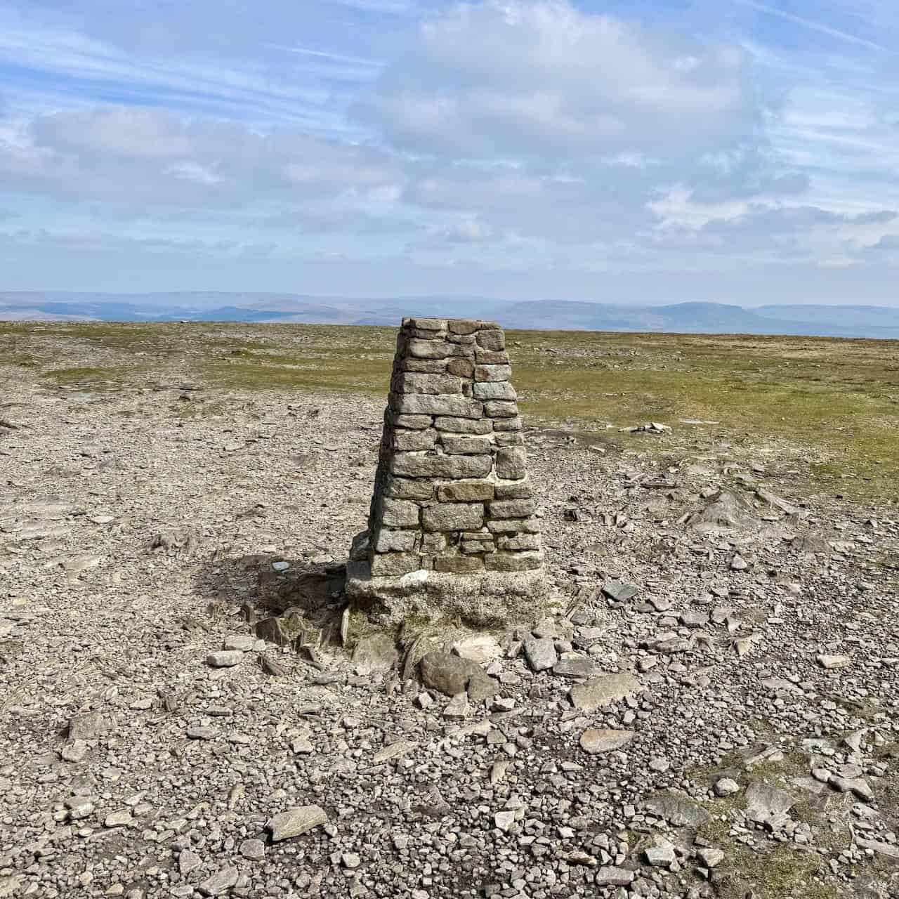
I visit the triangulation pillar marking Ingleborough’s summit at 724 metres (2375 feet). As I mentioned earlier, the mountain has a very broad, flat plateau. I have been up here on many occasions, and navigating off the mountain in foggy conditions can become quite tricky.
ADVERTISEMENT
Having visited the triangulation pillar and the mountain’s seating area, I return to the two large piles of stones, or cairns, where I was earlier. Returning to these cairns helps me find the path off the mountain more easily. Keeping to my left-hand side is always the best option. This is because the path leading down from the mountain is located in the north-eastern corner of the broad, flat plateau. I have seen, on past occasions, many people unable to find the exit path off the mountain. This is because, when they leave the seating area, they wander across the middle of the mountain instead of heading towards the left-hand side and following the path along the northern edge.

Near the two large cairns, I locate the exit path in the north-eastern corner of the broad, flat plateau. It consists of a series of large, stepped boulders. To the right of the path, a cluster of weathered grey rocks juts out over the slope, their rough surfaces layered and cracked by centuries of exposure to the elements. The largest slab, almost triangular in shape, balances at an angle atop a natural stack, giving the impression it might topple with the next strong gust of wind, though it has no doubt stood firm for many years.

Shortly afterwards, as I descend, the path becomes well-made, with a series of flat, large stone paving slabs set into the ground. The path splits into two here, marked by a concrete post roughly about three feet high. The path to the left leads walkers either steeply back down to Humphrey Bottom or along a permissive path that skirts the western sides of Simon Fell and Park Fell. I will be taking the path to the right, which forms part of the Dales High Way. This is also the path taken by participants of the Yorkshire Three Peaks Challenge when they are heading back down to the village of Horton in Ribblesdale.
I descend the mountain on the Dales High Way across an area known as Simon Fell Breast. Looking back, I get a magnificent view of the ridge I crossed earlier from Little Ingleborough to Ingleborough itself.

ADVERTISEMENT
The path across Simon Fell Breast levels out for a while but then starts to steepen again as it descends to Nick Pot. The path is well-worn by tens of thousands of walkers every year. It is uneven and rocky in places, a mixture of compacted and scattered stones with occasional large boulders. However, it remains clear and easy to follow. In the distance, I can see Pen-y-ghent dominating the horizon, with its smaller companion, Plover Hill, to its left.

As I descend towards Nick Pot, some parts of the path are very well maintained, with large, flat paving slabs to prevent erosion from the extremely high footfall in this area. It is breathtaking out here; the pathway winds its way through the expansive grassland, which has turned golden with the season.

Shortly before arriving at Nick Pot, I pass an old, abandoned shooting hut, very much in disrepair and falling apart. Then I arrive at the split in the path at Nick Pot. The left-hand path leads east back to Horton in Ribblesdale. But it is now time to leave the rest of the Three Peaks Challenge walkers because I am turning right, using the right-hand fork to head south. The split in the path is marked by a single wooden post, with no nameplates, just a yellow public footpath waymarker arrow attached to it.

My path between Nick Pot and Long Scar is extraordinary. In the foreground, an extensive stretch of limestone pavement stretches out across the landscape, its surface broken into a jigsaw of clints (blocks) and grikes (deep fissures). The grey limestone is weathered and worn smooth by centuries of rain and wind, creating an almost sculptural effect. Tufts of hardy grass and small plants grow in the cracks and crevices, clinging stubbornly to life in this harsh, exposed environment. Beyond the pavement, the distinctive twin peaks are visible in the distance. To the left is Little Ingleborough, and to the right stands the iconic flat-topped summit of Ingleborough itself, its bold outline dominating the skyline.

I get breathtaking views across the limestone pavement, this time with the distinctive outline of Pen-y-ghent rising in the distance. Limestone pavement is formed over thousands of years by a combination of natural processes. It begins with a thick layer of limestone rock, originally laid down under ancient seas. During the Ice Age, glaciers scraped away the soil covering the limestone, leaving the bare rock exposed. After the ice retreated, rainwater, which is slightly acidic, slowly seeped into the natural cracks in the limestone. Over time, the water widened these cracks to create deep fissures called grikes, while leaving the blocks of rock in between, known as clints.

ADVERTISEMENT
I reach the Pennine Bridleway at Long Scar. A huge, impressive, stone-built cairn marks a high point in this area at 393 metres. The cairn can be seen from quite some distance away and helps guide the way.

I follow the Pennine Bridleway along a track called Long Lane. The lane is on the eastern side of the Clapham Beck valley, where I was earlier in the day. Looking to my right, I get a marvellous view down to Ingleborough Cave.

Long Lane certainly lives up to its name. It is indeed long and seems to take ages to reach the end of it, especially on tired legs towards the end of my Ingleborough walk.

At the end of Long Lane, I take a right and follow another charming track called Thwaite Lane, now heading back towards Clapham. The path itself is wide and winds gently through the trees. On either side, traditional dry-stone walls line the way, their surfaces almost entirely cloaked in thick, golden-green moss, giving them a soft, velvety appearance.

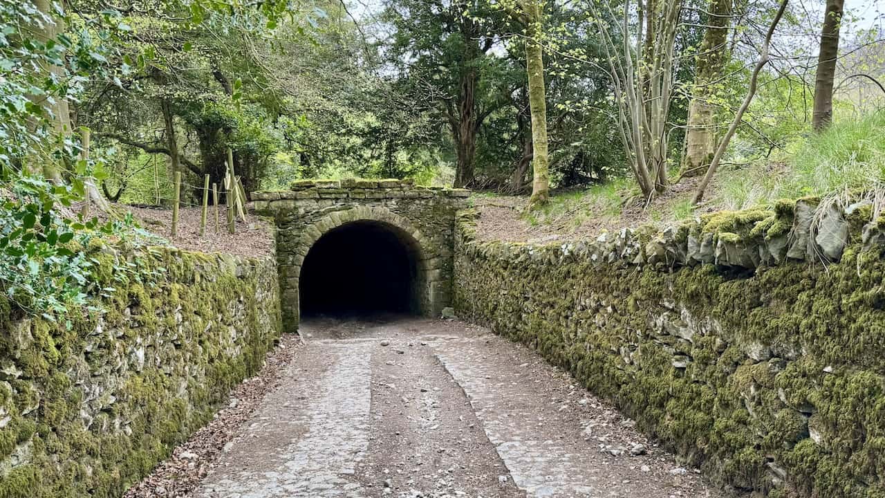
As I make my way along Thwaite Lane, I reach the Clapham tunnels, a fascinating feature of the Ingleborough Estate, reflecting the grandeur and privacy concerns of Victorian estate planning. In the early 19th century, the Farrer family, owners of Ingleborough Hall, undertook significant landscaping projects to enhance their estate. To ensure privacy from passers-by using Thwaite Lane, they constructed these two tunnels. These tunnels allowed the public path to pass beneath the estate’s landscaped grounds, enabling the Farrers and their guests to enjoy uninterrupted strolls through their ‘back garden’ without encountering the public.
ADVERTISEMENT
Now back in the village of Clapham, I pass St James’ Church. It is a beautiful, historic building with parts dating back to the late medieval period, although it was heavily restored in the 19th century under the direction of the Farrer family, who owned Ingleborough Hall. The church is built mainly of local limestone and stands close to Clapham Beck, near the centre of the village. St James’ is known for its peaceful setting, attractive churchyard, and fine Victorian stained glass. Inside, there are several interesting memorials, including ones connected to the Farrer family. My Ingleborough walk has been absolutely unforgettable.

ADVERTISEMENT