Follow This Step-by-Step Route for an Unforgettable Pen-y-ghent Walk
This Pen-y-ghent walk begins in the heart of Horton in Ribblesdale, a charming village in the Yorkshire Dales often used as a gateway to one of the area’s most iconic peaks. Start your day by parking in the Yorkshire Dales National Park car park, located in the centre of the village. Public toilets are available here. The car park is a decent size, though it does fill up quickly, especially at weekends. Horton in Ribblesdale is a popular starting point for the Yorkshire Three Peaks Challenge, so if the car park is full, look for additional roadside parking around the village.
From the car park, turn right and walk south along the B6479. You’ll pass a row of terraced houses on your right-hand side. Ignore the first bridleway on your left, which is signposted as the Pennine Way to Foxup and Pen-y-ghent. Continue along the road, passing the Golden Lion Hotel on your right and St Oswald’s Church on your left. The road curves gently to the left, following the B6479 towards Settle.
Cross Horton Bridge over the stream. Immediately after the bridge, turn left onto a narrow tarmac road. Follow this quiet lane past Broad Croft House Bed & Breakfast on your right, then continue past the former Horton in Ribblesdale Church of England Primary School, also on the right. The road begins to climb gradually and soon bends around to the right.
After around half a mile, you’ll reach the first farm buildings in the hamlet of Brackenbottom. Ignore the footpath on your left, which is part of the Yorkshire Three Peaks Challenge route leading directly to the Pen-y-ghent summit. Stay on the road as it winds through Brackenbottom, continuing straight ahead as the hamlet falls behind you.
Soon, you’ll arrive at a T-junction. Take the road to the left, which climbs gently uphill for about one-third of a mile. At the top, you’ll come to a cluster of farm buildings at Dub Cote. Turn left onto a wide stone track signposted to Pen-y-ghent. Walk past Dub Cote Farm on your left and continue uphill along the track. When you reach two gates, go through the one on the right.

Follow the grassy path as it rises up the hillside. It veers left, drawing close to a dry stone wall. Cross over a stile and continue as the neatly manicured path swings right, away from the wall. Keep climbing diagonally. Although it might feel like you’re heading away from Pen-y-ghent, the route is correct. Carry on uphill until you reach a broader, well-defined stone track. Turn left here.
Follow this track for over three-quarters of a mile. The path leads north-east towards Pen-y-ghent, offering sweeping views of the surrounding Dales. Eventually, you’ll reach a junction at Churn Milk Hole, a large hollow in the ground on your right-hand side. Turn left, following the sign for the Pennine Way to Pen-y-ghent.
Continue north along this well-marked trail. After around two-thirds of a mile, you’ll reach a point where another path joins from the left. This is the shorter route taken by some walkers from Horton in Ribblesdale. Walk straight ahead to begin your main ascent.
This is the halfway point of your Pen-y-ghent walk. The climb begins on large stone paving slabs and soon becomes a mixture of stone steps and boulders. There is a short section of light scrambling, but nothing too difficult. The final stretch returns to stone paving slabs. The path is clear and easy to follow. After about half a mile of ascent, you’ll reach the summit of Pen-y-ghent.

At the top, turn left through one of the gates in the dry stone wall, following the signpost for the Pennine Way and the Yorkshire Three Peaks Challenge route. Begin your descent along a wide stone track. It soon becomes a mix of large paving slabs and a compacted gravel path. The route is straightforward and well maintained.
After around half a mile, the path bends sharply to the left. Here, you’ll see a signpost for the Pennine Way, Horton in Ribblesdale, Yorkshire Three Peaks, and High Birkwith via Whitber. Keep following the same downhill path for another mile until you reach a clear crossroads.
At the crossroads, turn right along the public bridleway signposted to Foxup if you’d like to visit Hull Pot, a dramatic collapsed cavern. After exploring Hull Pot, retrace your steps to the crossroads.
Continue straight ahead from the crossroads, staying on the Pennine Way bridleway towards Horton in Ribblesdale. Follow this walled track as it stretches across Horton Scar for about 1½ miles. As you approach the edge of the village, the track forks into two. Take the right-hand fork and follow it downhill to reach the road.
Turn right along the road and walk a short distance back to the village centre. You’ll soon arrive at the car park, where your Pen-y-ghent walk comes to a satisfying close.
Pen-y-ghent Walk: Maps and Tools
Visit either the OS Maps website or the Outdooractive website to view this walking route in greater detail. Both platforms offer a range of features, including the ability to print the route, download it to your device, and export the route as a GPX file. You can also watch a 3D fly-over and share the route on social media. Additionally, this page includes a printable version of the walk in PDF format. Plus there is a supporting video, available for you to watch on YouTube.
Pen-y-ghent Walk: Distance, Duration, Statistics
Distance: 7½ miles
Distance: 12¼ kilometres
Duration: 4 hours
Ascent: 1658 feet
Ascent: 505 metres
Type: Circular walk


Walking in the Yorkshire Dales with 43 Circular Routes
AD This Cicerone guidebook includes 43 circular walks exploring valleys, hills, and moors between Kirkby Stephen and Pateley Bridge. With OS maps, local highlights, and routes ranging from 3–11 miles, it is a year-round companion for walkers of all abilities.
Recommended Ordnance Survey Map
The best map to use on this walk is the Ordnance Survey map of the Yorkshire Dales Southern & Western Area, reference OS Explorer OL2, scale 1:25,000. It clearly displays footpaths, rights of way, open access land and vegetation on the ground, making it ideal for walking, running and hiking. The map can be purchased from Amazon in either a standard, paper version or a weatherproof, laminated version, as shown below.
Standard Version
About Pen-y-ghent
Pen-y-ghent is a fell in the Yorkshire Dales. At 694 metres (2277 feet), it is the lowest of the Yorkshire Three Peaks, the other two being Ingleborough and Whernside. The summit lies approximately 1.9 miles (3 kilometres) east of Horton in Ribblesdale.
Yorkshire Three Peaks: Watch the Flyover Videos on YouTube
Pen-y-ghent Flyover | Whernside Flyover | Ingleborough Flyover
The fell features several notable geological formations, including Hunt Pot and, further down the slope, Hull Pot. Water flowing into these features has formed an extensive cave system, which eventually resurfaces at Brants Gill Head.
The name ‘Pen-y-ghent’ has its roots in the Cumbric language. As in modern Welsh, pen means ‘top’ or ‘head’, and y is the definite article, ‘the’. This is similar to other Welsh place names such as Pen-y-berth (‘end of the hedge or copse’) and Pen-y-ffordd (‘head of the road or way’).
The final element, ghent, is more obscure. It may derive from a word meaning ‘edge’ or ‘border’, suggesting that the name could mean ‘Hill on the border’ – perhaps similar in origin to ‘Kent’. Alternatively, ghent may come from gïnt, meaning ‘a heathen’ or ‘a gentile’ (from the Latin gentis; compare Welsh gynt), possibly referencing Scandinavian pagans.
Geologically, Pen-y-ghent consists of a millstone grit cap resting on a base of carboniferous limestone. Its summit forms a watershed: water flows eastward into the River Skirfare, continuing through to the Humber Estuary, while water flowing west drains into the River Ribble, eventually reaching the Irish Sea.
The fell’s distinctive rakes, particularly visible on its western flank, were exposed during a severe storm in July 1881. The storm’s powerful rainfall stripped away the topsoil, revealing the underlying rakes that had long been hidden.
Pen-y-ghent Walk: My Photos
After parking up in Horton in Ribblesdale, I begin my Pen-y-ghent walk by making my way south through the village and past St Oswald’s Church. It’s a Grade I listed parish church dedicated to Saint Oswald, the 7th-century King of Northumbria. The church may date back as far as the 10th century and is recorded in The Domesday Book, indicating its long-standing importance in the region. The present building was begun in the 12th century, and the nave from this period survives almost entirely intact. This makes it one of the most complete Norman churches in the Yorkshire Dales, built after the Norman Conquest and the devastating ‘Harrying of the North’. The south doorway and the tub-shaped font are also Norman in style, both richly decorated with zigzag carving. The square west tower, with its three stages, diagonal buttresses, and embattled parapet, was added in the 14th century and features Perpendicular windows and a finely detailed west entrance.


Grisport Unisex Adult Peaklander Hiking Boots
AD The Grisport Unisex Adult Peaklander Hiking Boots are crafted in Italy with a durable waxed leather upper, Spotex breathable lining, and a reliable Track-on rubber sole. Waterproof and weighing just 1120g, they offer comfort, resilience, and dependable performance on demanding trails.
Much of the remainder of the church dates from the 15th century, although it underwent significant restoration in the 19th century. The north aisle was rebuilt between 1823 and 1825, and further alterations were made between 1879 and 1880, when the aisle roofs were modified to match the slope of the nave roof. The Norman doorway was carefully restored in 1980. Built of stone with a lead roof, the church consists of a nave flanked by north and south aisles, a gabled south porch, a chancel with chapels on either side, and a prominent west tower. Access to the churchyard is through lych gates roofed with massive slabs of local Horton slate. Although the church is now dedicated to Saint Oswald, it was formerly dedicated to Saint Thomas Becket.

From the church, I follow a quiet country lane past Broad Croft House Bed & Breakfast—a welcoming, family-run B&B perfectly placed for walkers tackling the Yorkshire Three Peaks Challenge or exploring the Pennine Way. Guests can choose from three comfortable en-suite bedrooms in the main house or two well-equipped, dog-friendly micro-lodge pods set in a peaceful walled garden.

Grisport Unisex Adult Peaklander Hiking Boots
AD The Grisport Unisex Adult Peaklander Hiking Boots are crafted in Italy with a durable waxed leather upper, Spotex breathable lining, and a reliable Track-on rubber sole. Waterproof and weighing just 1120g, they offer comfort, resilience, and dependable performance on demanding trails.
A little further along the lane, I pass the former Horton in Ribblesdale Church of England Primary School, a single-storey building constructed in traditional local stone with a pitched slate roof. It served the local community for many years, educating generations of children in this rural area. Like many village schools in the Yorkshire Dales, it was closely tied to the local church, St Oswald’s. The school closed in 2017 due to declining pupil numbers—a common challenge for rural schools in sparsely populated areas.

I make my way through Brackenbottom and up to Dub Cote, joining the track which forms part of A Pennine Journey. At a modest elevation of about 300 metres, the views really start to open up. Looking to the west, I can easily make out Horton Quarry and, of course, the familiar profile of Ingleborough on the horizon.

Fifty Walks Across the Beautiful North York Moors National Park
AD Discover 50 routes across the North York Moors, from short easy strolls to challenging high-level hikes. With OS maps, route descriptions, and local highlights, it also includes the legendary 40-mile Lyke Wake Walk, described in four accessible stages.
I’m glad I chose this slightly longer route from Horton in Ribblesdale up to Pen-y-ghent. It’s peaceful and quiet, and the views of the surrounding countryside are spectacular. It’s a great start to my Pen-y-ghent walk. As well as Ingleborough on the horizon, I can also see Whernside. Walkers participating in the Yorkshire Three Peaks Challenge will summit both of these mountains, along with Pen-y-ghent.

I continue to gain height on my Pen-y-ghent walk, now at around 440 metres, following a northerly track across Dub Cote Scar Pasture. The southern aspect of Pen-y-ghent comes into view as I follow this easy-to-navigate track on a glorious day.

Fifty Walks Across the Beautiful North York Moors National Park
AD Discover 50 routes across the North York Moors, from short easy strolls to challenging high-level hikes. With OS maps, route descriptions, and local highlights, it also includes the legendary 40-mile Lyke Wake Walk, described in four accessible stages.
I walk past a classic example of a limestone shakehole, or swallow hole—a natural depression formed in the karst landscape of the Yorkshire Dales. These features develop when slightly acidic rainwater seeps through cracks in the limestone, gradually dissolving the rock and widening the fissures over thousands of years. Sometimes, the roof of an underground cavity collapses, causing the ground above to sink or give way, forming a visible surface hole like this one. Shakeholes are common in upland limestone areas, particularly around Pen-y-ghent and the surrounding fells, where the landscape is riddled with caves, potholes, and underground streams. The Dales are famous for this type of geology, which has created a dramatic and often hidden subterranean world beneath the grassy moorland.
There are also examples of limestone pavement—another distinctive geological feature commonly found in the Yorkshire Dales. These pavements were formed during the last Ice Age, around 12,000 years ago, when advancing glaciers scraped away the overlying soil and exposed the flat beds of limestone beneath. Once uncovered, the limestone began to weather through a process known as chemical weathering. Rainwater, made slightly acidic by absorbing carbon dioxide from the atmosphere, gradually dissolved the rock along natural joints and cracks. This created a pattern of deep grykes (the fissures) and flat-topped blocks called clints. Over time, the surface developed a ‘paving slab’ appearance, with the clints often becoming home to specialised plants that thrive in the sheltered microclimate of the grykes.


Osprey Hikelite Unisex Backpack for Comfortable and Lightweight Hiking
AD The Osprey Hikelite backpack combines lightweight design with practical features, including a breathable mesh back panel, soft webbing straps, and stretch mesh water bottle pockets. With zipped storage and an organiser compartment, it is ideal for day hikes and outdoor use.
I reach the junction with the Pennine Way. This is the location of Churn Milk Hole—a much larger version of the shakehole I saw earlier. It was formed over thousands of years as slightly acidic rainwater percolated through natural joints and bedding planes in the limestone, gradually enlarging them and causing the surface rock to collapse inward. The name Churn Milk Hole is thought to derive from its historical use as a cool storage spot for milk churns before the advent of refrigeration.

At this junction, it’s time for me to turn left and follow the Pennine Way in the direction of Pen-y-ghent. The mountain is looming ever closer, and I can already see the ant-like figures of people making their way up the steep part of the ascent.

Osprey Hikelite Unisex Backpack for Comfortable and Lightweight Hiking
AD The Osprey Hikelite backpack combines lightweight design with practical features, including a breathable mesh back panel, soft webbing straps, and stretch mesh water bottle pockets. With zipped storage and an organiser compartment, it is ideal for day hikes and outdoor use.
The track north towards the mountain from Churn Mill Hole rises gently. It’s easy to follow and navigate, with a compacted gravel surface that’s comfortable to walk along. But I know this pleasant gradient is about to change very soon.
I reach the point where I’m joined from the left by other walkers who’ve taken the more direct approach across Brackenbottom Scar from Horton in Ribblesdale. This route is popular with those doing the Yorkshire Three Peaks Challenge. The ascent now steepens significantly, and I remain on the Pennine Way. This path is used by tens of thousands of walkers each year. A well-laid stone staircase helps to manage erosion and guide people safely up the incline.


Peak Bagging Wainwrights with Routes to Complete All Fells
AD This comprehensive guide offers 45 circular routes linking all 214 Wainwright fells. With maps, GPX downloads, elevation profiles, and practical advice, it provides efficient yet inspiring ways to complete this classic Lake District challenge at your own pace.
The stone-pitched path climbs through a scatter of loose gritstone boulders and scree, giving way to a more rugged and uneven terrain. Ahead, the summit crags come clearly into view, their dark, weathered faces forming a jagged outline against the sky. The route briefly becomes a light scramble, requiring the use of my hands as I pick my way up the rock steps and ledges. It’s not technical, but it can feel slightly exposed in places, especially in poor weather. Cairns guide the way, though they’re hardly necessary—the route is obvious. On the whole, it really isn’t a problematic mountain to climb. I’m roughly at the halfway point of my Pen-y-ghent walk.

I reach the triangulation pillar at the summit of Pen-y-ghent, height 694 metres (2277 feet). I turn left here, heading through one of the gaps in the dry stone wall.
Peak Bagging Wainwrights with Routes to Complete All Fells
AD This comprehensive guide offers 45 circular routes linking all 214 Wainwright fells. With maps, GPX downloads, elevation profiles, and practical advice, it provides efficient yet inspiring ways to complete this classic Lake District challenge at your own pace.
Attached to the wall of one of the seating areas at the summit of Pen-y-ghent is a metal plaque reading:
In celebration of the 50th anniversary of the Yorkshire Dales National Park
12th October 2004

My route down from Pen-y-ghent is extremely clear and easy to follow. It begins with a set of large stone paving slabs, designed to prevent erosion that would otherwise be caused by the tens of thousands of people who walk this path every year. The two other peaks—Ingleborough and Whernside—continue to dominate the horizon in this area.


Berghaus Hillmaster II GTX Men's High Rise Hiking Boots
AD The Berghaus Hillmaster II GTX men’s hiking boots feature a waterproof, breathable GORE-TEX membrane, a memory foam tongue and collar for a personalised fit, and a Vibram sole delivering exceptional grip, stability, and shock protection for confident performance on any terrain.
As I descend, I can make out a small tarn in the middle of the moorland. Just beyond that lies Hull Pot, a deep hollow in the landscape and my next destination.

Visiting Hull Pot will be a slight detour, and although I’ve seen it before, it’s definitely a spectacle I want to visit again. It always adds something special to my Pen-y-ghent walk.

Berghaus Hillmaster II GTX Men's High Rise Hiking Boots
AD The Berghaus Hillmaster II GTX men’s hiking boots feature a waterproof, breathable GORE-TEX membrane, a memory foam tongue and collar for a personalised fit, and a Vibram sole delivering exceptional grip, stability, and shock protection for confident performance on any terrain.
The straightforward path descending Pen-y-ghent passes the millstone grit escarpment on the mountain’s western side. These cliffs show a textbook example of the mountain’s distinctive geological layering. The visible escarpment is made up of millstone grit, a coarse-grained sandstone that forms the uppermost cap of the hill. This hard, resistant rock sits on top of a much softer layer of Carboniferous limestone, which is more easily eroded by weather and water. Over time, the erosion of the lower limestone has caused the overlying gritstone to collapse and break away, forming the dramatic crags and scree slopes seen here. The area beneath the cliffs is strewn with large blocks that have tumbled down from above.

The majority of the path down is made up of compacted gravel and stone. Although it can be slightly jarring on the knees, I find it absolutely fine to walk down. Horton Quarry is easily visible. Located just west of Horton in Ribblesdale, the quarry is a prominent feature in the landscape. Established in 1889, it has a long history of producing high-quality limestone, primarily for construction and industrial purposes. Initially, stone was transported via the Settle to Carlisle Railway, but operations switched to road transport after the rail connection was lost in 1965. Over the years, Horton Quarry has changed ownership multiple times and is currently operated by Heidelberg Materials UK (formerly Hanson). The quarry has permission to extract up to 600,000 tonnes of limestone annually, with operations expected to continue until 2042. In addition to its industrial activities, the quarry has contributed to environmental initiatives, including the donation of 600 tonnes of stone in 2021 to re-line the path up to the summit of Ingleborough.


Kendal Mint Co Energy Gel with Citrus and Mint Flavour
AD Kendal Mint Co energy gels deliver 27g of fast-absorbing carbohydrates plus electrolytes and B vitamins for improved performance. Vegan, gluten free, and Informed Sport certified, these caffeine-free gels are refreshing, easy to digest, and ideal for running, cycling, and endurance.
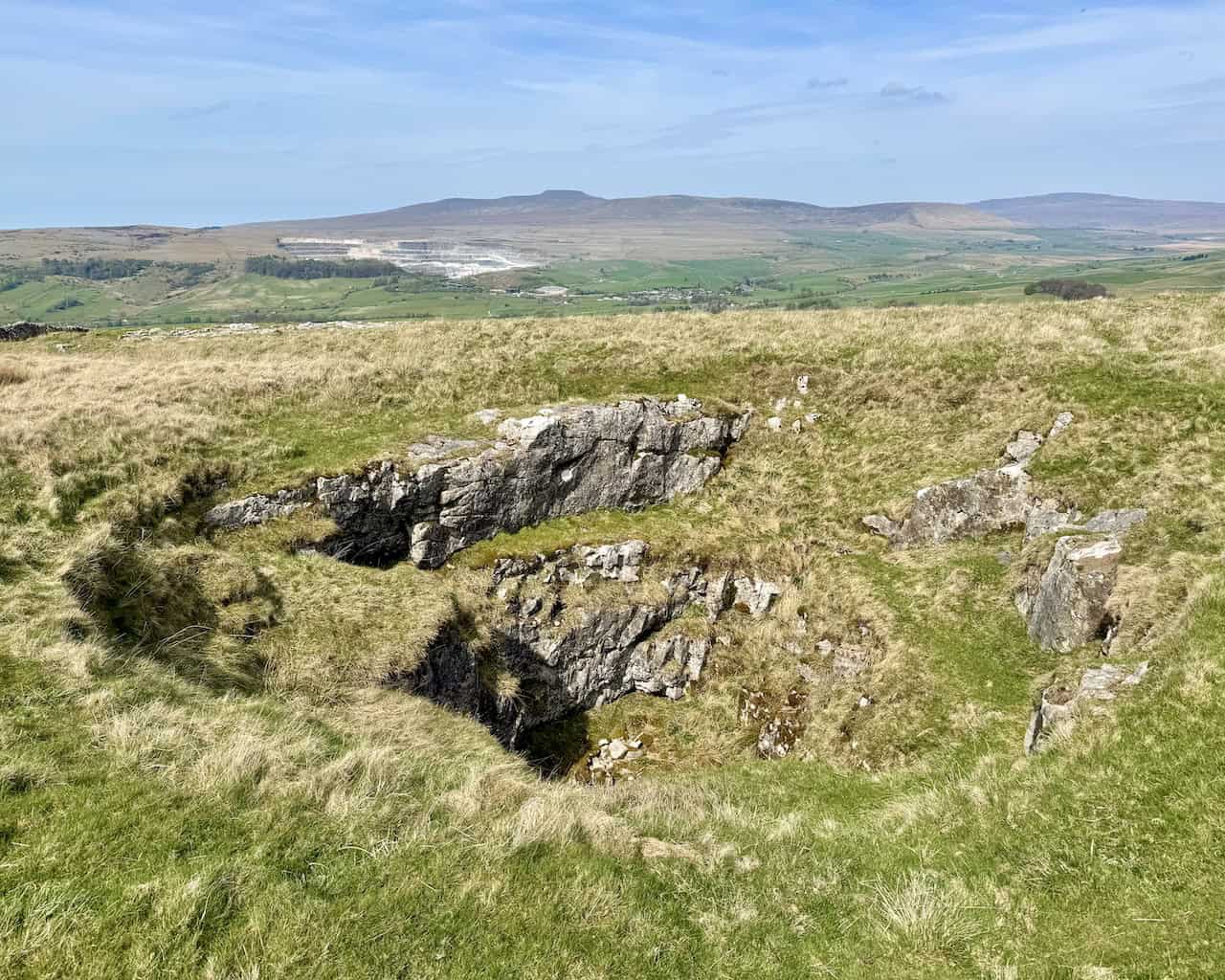
Hull Pot
With the main part of the descent from Pen-y-ghent over, I reach a crossroads and then make my detour to visit Hull Pot, a large natural depression located on Horton Moor. It is considered the largest natural hole in England, measuring approximately 91 metres (300 feet) in length, 18 metres (60 feet) in width, and 18 metres (60 feet) deep.

The formation of Hull Pot is the result of karstic processes acting on the local Carboniferous limestone, a type of sedimentary rock laid down around 350 million years ago. Over time, slightly acidic rainwater dissolved the limestone through its natural joints and fissures, gradually enlarging underground passages until the roof of a cavern collapsed. The result is the open-sided chasm we see today.

Kendal Mint Co Energy Gel with Citrus and Mint Flavour
AD Kendal Mint Co energy gels deliver 27g of fast-absorbing carbohydrates plus electrolytes and B vitamins for improved performance. Vegan, gluten free, and Informed Sport certified, these caffeine-free gels are refreshing, easy to digest, and ideal for running, cycling, and endurance.
A stream called Hull Pot Beck flows from the slopes of nearby Plover Hill and normally disappears underground before reaching the pot. In dry weather, it bypasses the chasm entirely via subterranean routes. However, after heavy rainfall, the stream can overflow directly into Hull Pot, forming a striking waterfall that plunges into the chamber. In extreme flood conditions, the entire pot can fill with water and overflow onto the surrounding moorland.

The surrounding geology and hydrology of Hull Pot are of interest to both geologists and speleologists. The pot forms part of a broader karst system typical of the Yorkshire Dales, characterised by shakeholes, underground streams, and extensive cave networks. It provides a surface expression of deeper subterranean activity, although no major cave system has yet been fully mapped beneath it.


Thermos Stainless King Flask for Travel and Daily Adventures
AD The Thermos Stainless King 470ml flask keeps drinks hot for 18 hours or cold for 24. With durable stainless steel, vacuum insulation, a serving cup, and a leakproof design, it is perfect for commutes, journeys, and outdoor adventures.
Hull Pot is accessible directly from Horton in Ribblesdale, via a lane that leads across Horton Scar. This is the route I’ll be using to return to the village. Hull Pot is an absolute highlight of my Pen-y-ghent walk.

After visiting Hull Pot, I make my way back to the crossroads and follow the Pennine Way public bridleway, signposted to Horton in Ribblesdale. I have about a mile and a half to go.

Thermos Stainless King Flask for Travel and Daily Adventures
AD The Thermos Stainless King 470ml flask keeps drinks hot for 18 hours or cold for 24. With durable stainless steel, vacuum insulation, a serving cup, and a leakproof design, it is perfect for commutes, journeys, and outdoor adventures.
My route back to the village follows A Pennine Journey across Horton Scar. From this vantage point, I’m treated to a sweeping view of Pen-y-ghent’s broad western flank, rising steeply above the surrounding moorland. The mountain’s distinctive stepped profile is clearly visible, with a dark band of millstone grit crowning the summit ridge. Below this, the gentler, paler slopes reflect the underlying Carboniferous limestone, which gradually descends to the grassy pastures of Horton Moor.

From the summit of Pen-y-ghent, the high ground continues northwards—off to the left—along a long ridge that leads to Plover Hill. This northern extension is part of the same geological structure and adds to the massif’s dramatic profile when seen from the west. The entire formation is a textbook example of the layer-cake geology found throughout the Yorkshire Dales, where erosion has shaped the softer limestone beneath the tougher gritstone cap.

Lake District High Level and Fell Walks with Thirty Routes
AD This pocket-sized guide presents 30 routes on the Lake District’s highest fells, including Scafell Pike, Helvellyn, and Blencathra. With OS maps, colour photographs, and practical notes, it offers circular walks from 4–15 miles graded by difficulty.
I follow the lane back into the village. It’s a lovely track, bordered by dry stone walls on either side. One of the walls is covered in thick green moss. It’s a quiet and peaceful way to end my Pen-y-ghent walk.
