ADVERTISEMENT
Reach the Highest Peak in the Yorkshire Dales on the Whernside Walk
You’ll begin your Whernside walk with roadside parking along the B6255 Blea Moor Road, close to the iconic Ribblehead Viaduct. Although there are usually plenty of spaces, bear in mind that this area is extremely popular with both walkers and sightseers, so it’s wise to arrive early if you want to secure a good spot.
From the parking area, head towards the road bridge at the junction of the B6255 and the B6479. From the bridge, follow the public footpath signposted ‘Yorkshire Three Peaks’ and ‘Bleamoor Sidings’, making your way towards the Ribblehead Viaduct. Near the viaduct, as the wide stone track bends to the left, take the narrower path on your right, signposted to Whernside. Follow this route with the viaduct on your left-hand side, and begin your ascent via the stepped stone path that climbs the embankment.
Keep the dry stone wall on your left as you continue, and ignore the first left turn, which leads through a railway tunnel. Stay on the main footpath until you reach Bleamoor Sidings. Here, avoid the bridleway on your left, which also leads through a tunnel towards Winterscales. Instead, continue straight ahead, following the bridleway signposted ‘Yorkshire Three Peaks’ and ‘Dent’. You’ll pass the Blea Moor Signal Box and an abandoned railway cottage before continuing along the track through Little Dale.
Cross Little Dale Beck using a wooden footbridge, and a short while later you’ll come to the Force Gill Aqueduct. Cross the Settle to Carlisle railway line and ignore the right-hand path signposted to Dent Head. Instead, climb the stone steps ahead, following the bridleway signposted to Dentdale. The route becomes steeper here as you follow the Dales High Way up Slack Hill.

ADVERTISEMENT
Keep climbing until the route splits in two. The left-hand fork, signposted ‘Yorkshire Three Peaks’ and ‘Whernside’, passes through a gate and is the path used by most walkers, including participants in the Yorkshire Three Peaks Challenge. If you prefer a shorter Whernside walk, this is the route to take, shaving around 2 miles (3.2 kilometres) off your journey and leading you directly to the summit.
For the longer and quieter option, continue straight ahead uphill along the bridleway signposted to Deepdale. The path begins to level out as you cross the grassy moorland of Craven Wold. After more than half a mile (0.8 kilometres), you’ll reach the ruins of an old stone building at Duncan Sike Foot. Bear left in front of the ruins and follow the grassy trail across Great Wold.
Look out for a distinctive area of exposed limestone boulders and rocks on your right-hand side. Shortly after, you’ll reach Boot of the Wold and the corner of a dry stone wall. If you find yourself among walled livestock enclosures, you’ve gone too far. There’s no signpost here, but turn left and follow the path running alongside the fence and wall. You’re now on the route of A Pennine Journey, heading uphill towards Whernside Tarns.
As the wall curves to the right, stay straight ahead on the grassy track. The route is firm and well-trodden—if you find yourself in boggy ground or long grass, you’ve likely veered off course. Continue uphill, and soon Whernside will come into view. You’ll pass the eastern side of one of the larger Whernside Tarns, followed by a smaller tarn on Knoutberry Hill. This marks the approximate halfway point of your Whernside walk.
Keep following the path gently uphill towards Whernside. After one final push, you’ll reach a fence with a stile. Cross over, turn right, and you’ll join the main trail used by most walkers and Three Peaks Challenge participants. From here, follow the track and large stone steps uphill for another half a mile (0.8 kilometres) to reach the summit of Whernside.

ADVERTISEMENT
At the top, pass the triangulation pillar on your right and continue ahead, gently descending alongside the dry stone wall. After about three-quarters of a mile (1.2 kilometres), the path begins to descend more steeply. When it veers left away from the wall, follow it. You’ll remain on A Pennine Journey as the descent steepens further, but the path stays clear and well maintained, with large paving stones and flattened rocks underfoot.
After more than three-quarters of a mile (1.2 kilometres) downhill, the path levels out. You’ll pass through a scatter of limestone boulders, and a stone barn with a slate roof will appear ahead. Just after the barn, turn left onto a public bridleway signposted to Winterscales.
Follow the path through grassy meadows and continue through the farm at Broadrake. Keep going along the well-defined track for about half a mile (0.8 kilometres) until you reach the farm at Ivescar. Walk straight through, following the bridleway signposted to Deepdale, and avoid the right-hand path to Winterscales Beck.
As the track becomes a tarmac lane, continue straight ahead. After passing a collection of limestone boulders in the field on your right, the road bends to the right and is signposted to the viaduct. Do not continue straight ahead towards Deepdale and Whernside. Instead, follow the lane downhill towards Gunnerfleet Farm.
Once past the barns and farmhouses, turn left and cross Winterscales Beck via the bridge. The Ribblehead Viaduct will soon come into view as you walk along the stony track past more farm buildings and the Three Peaks Pods. Continue under the viaduct and retrace your earlier steps back to the parking area, bringing your Whernside walk to a rewarding close.
Whernside Walk: Maps and Tools
Visit either the OS Maps website or the Outdooractive website to view this walking route in greater detail. Both platforms offer a range of features, including the ability to print the route, download it to your device, and export the route as a GPX file. You can also watch a 3D fly-over and share the route on social media. Additionally, this page includes a printable version of the walk in PDF format. Plus there is a supporting video, available for you to watch on YouTube.
Whernside Walk: Distance, Duration, Statistics
Distance: 10 miles
Distance: 16¼ kilometres
Duration: 5¼ hours
Ascent: 1757 feet
Ascent: 536 metres
Type: Circular walk

ADVERTISEMENT
Recommended Ordnance Survey Map
The best map to use on this walk is the Ordnance Survey map of the Yorkshire Dales Southern & Western Area, reference OS Explorer OL2, scale 1:25,000. It clearly displays footpaths, rights of way, open access land and vegetation on the ground, making it ideal for walking, running and hiking. The map can be purchased from Amazon in either a standard, paper version or a weatherproof, laminated version, as shown below.
Standard Version
Yorkshire Dales Walking Guidebooks
Walking in the Yorkshire Dales: South and West, by Jan and Dennis Kelsall, describes 44 circular day walks of 3.5 to 13 miles across Wharfedale, Littondale, Malhamdale, Dentdale and Ribblesdale, plus the Yorkshire Three Peaks Challenge, with Ordnance Survey mapping and notes on parking and refreshments.
Short Walks Yorkshire Dales, by Rachel Crolla and Carl McKeating, covers the area around Grassington, Skipton, Malham and Ilkley. Its 15 routes of 2.5 to 6 miles each take under three hours, ideal for families or a relaxed half day out. Both books can be purchased from Amazon, as shown below.
Walking the Yorkshire Dales
About Whernside
Whernside is a mountain in the Yorkshire Dales in the north of England and holds the title of the highest of the Yorkshire Three Peaks, the other two being Ingleborough and Pen-y-ghent. Standing at 736 metres (2414 feet), it is not only the highest point in the Yorkshire Dales National Park but also the tallest summit in the ceremonial county of North Yorkshire and the historic West Riding of Yorkshire. The summit itself lies on the county boundary with Cumbria. Whernside is ranked as the fifteenth most prominent hill in England.
Yorkshire Three Peaks: Watch the Flyover Videos on YouTube
Pen-y-ghent Flyover | Whernside Flyover | Ingleborough Flyover
In terms of shape, Whernside forms a long ridge running roughly from north-north-east to south-south-west. It lies about 6 miles (10 kilometres) north-west of Ingleton and the same distance north of Horton in Ribblesdale. While some may consider Whernside to be less visually striking than its more rugged neighbours, Ingleborough and Pen-y-ghent, the summit offers spectacular panoramic views. Features such as the Greensett Moss tarn and Force Gill on its eastern flanks add further interest to the landscape.
The name ‘Whernside’, first recorded in 1208 as Querneside, originates from Old English. It combines cweorn, meaning ‘quern’ or ‘millstone’, and sīde, meaning ‘hillside’—giving the name the meaning ‘hillside where millstones are found’. It shares this etymology with Great Whernside, located 17 miles (27 kilometres) to the east, with which it is sometimes confused.
Geologically, Whernside is typical of the Yorkshire Dales, with a structure that reveals its ancient origins. The summit is capped with millstone grit, a hard sedimentary rock formed during the Carboniferous period around 300 million years ago. Beneath this lies a layer of limestone, also from the Carboniferous, which forms much of the Dales’ characteristic terrain.
This combination of millstone grit over limestone creates a distinctive profile, contributing to the development of caves and potholes on the mountain’s slopes. Notable examples include Bruntscar Cave and Gatekirk Cave. The limestone belongs to the Yoredale Series, a geological formation made up of alternating bands of shale, mudstone, sandstone, and limestone. These sedimentary layers were originally deposited in a shallow tropical sea near the equator before tectonic forces shifted them to their present-day location. The millstone grit that caps Whernside represents the youngest and most erosion-resistant layer in this sequence.
Whernside’s parent peak is Cross Fell, and it appears on several hill listings including Marilyn, Hewitt, Hardy, County Top, and Nuttall. Despite its gentle ridge and relatively understated appearance, Whernside’s prominence, geological interest, and far-reaching views make it a highlight of any walk in the Yorkshire Dales.
Whernside Walk: My Photos
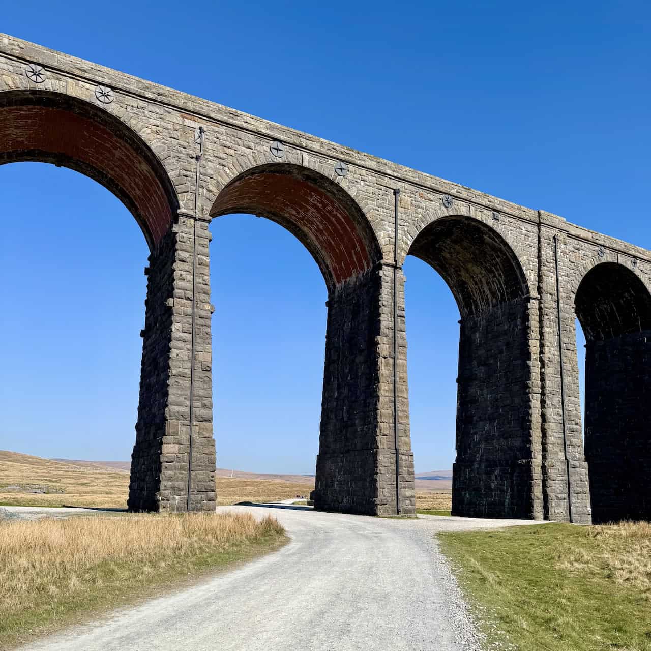
From the roadside car parking area on the B6255, I set off along the stony track that crosses Batty Green, heading towards the magnificent Ribblehead Viaduct. It’s an imposing structure, its 24 towering arches rising against the dramatic backdrop of Whernside. Built by the Victorians, the viaduct carries the Settle to Carlisle Railway high above the moorland.

ADVERTISEMENT
The Ribblehead Viaduct was constructed between 1870 and 1874 by the Midland Railway. Much of the work was carried out by navvies who lived in temporary camps scattered across the surrounding moorland. As I approach the viaduct, the broader track curves to the left, but I follow the narrower footpath on the right-hand side, which is clearly signposted to Whernside.

I continue along the footpath with the Ribblehead Viaduct on my left-hand side. The initially flat track soon begins to climb as it runs alongside the railway. This is a well-trodden route, and I pass plenty of other walkers — some likely on a short circular route, others perhaps tackling the Yorkshire Three Peaks Challenge.
ADVERTISEMENT
Staying on the main path, I ignore the left-hand turn that leads through the railway tunnel and carry straight on, walking alongside the Settle to Carlisle railway line.

The route is clearly defined and easy to follow. It’s a popular stretch, often busy with fellow walkers — many of whom are taking part in the Three Peaks Challenge, which adds energy to the trail.

ADVERTISEMENT
To my left, Whernside dominates the view. At 736 metres (2414 feet), it’s the highest mountain in the Yorkshire Dales National Park and a central highlight of the Whernside walk.

About a mile (1.6 kilometres) from the car park, I reach Bleamoor Sidings. I ignore the signposted left-hand turn through the railway tunnel towards Winterscales and instead continue straight ahead, following the bridleway signposted to the Yorkshire Three Peaks and Dent.

ADVERTISEMENT
I approach the Blea Moor Signal Box, then pass an old, abandoned railway cottage nearby. Built in 1878 as part of the Settle to Carlisle railway line, the signal box stands in a remote and windswept location.

The signal box has recently been refurbished and looks immaculate in the sunshine. Its crisp cream panelling and sharp maroon trim give it a freshly restored appearance. A metal plaque fixed to the side reads:
NATIONAL RAILWAY HERITAGE AWARDS
THE FIRST ENGINEERING AWARD
PRESENTED TO RAILTRACK NORTH WEST FOR
BLEA MOOR – RIBBLEHEAD
DRY STONE WALLING
BY HER ROYAL HIGHNESS
THE PRINCESS ROYAL
2002

ADVERTISEMENT
From Bleamoor Sidings, I continue heading north along the bridleway and cross Little Dale Beck via a wooden footbridge. There hasn’t been much rain recently, and the beck is looking unusually dry.

A short while later, I arrive at Force Gill Aqueduct — a remarkable piece of Victorian engineering. Built in the 1870s, the aqueduct is made entirely from stone and was designed to carry Force Gill over the railway line, protecting it from flooding.

Walking north from the aqueduct, I’m treated to a brilliant view of the railway line as it enters Bleamoor Tunnel — one of the most impressive feats on the Settle to Carlisle route. At approximately 1½ miles (2.4 kilometres) long, it’s the longest tunnel on the line. Constructed between 1872 and 1876, the tunnel was bored through Blea Moor by hand, aided by shafts sunk into the hillside to speed up excavation. The navvies endured incredibly harsh conditions here, made worse by the remoteness and exposure of the site.

ADVERTISEMENT
Beyond the viaduct, the path steepens. It forms part of the Dales High Way and is reinforced with stone flags to prevent erosion caused by the thousands of walkers who pass this way each year.
A little further along, I step away from the main trail to visit the waterfall formed by Force Gill. The water spills over a dark, moss-covered cliff of limestone and shale, falling into a plunge pool below. The diversion adds a scenic pause to the Whernside walk.

There hasn’t been much recent rainfall, so the waterfall is reduced to a trickle — but it remains a beautiful, peaceful spot. I’ve seen it in full force before, when the water crashes over the edge with impressive power.

ADVERTISEMENT
Roughly a quarter of a mile (0.4 kilometres) further on, the path splits. Most walkers aiming for the summit of Whernside — including those doing the Yorkshire Three Peaks — take the left-hand turn through the gates. Today, I choose to extend the walk by continuing straight ahead, climbing further uphill along the Dales High Way. The bridleway here is signposted to Deepdale.

The route climbs steadily across Craven Wold. In British geography, a ‘wold’ refers to high, open, rolling countryside, usually formed of chalk or limestone. The word comes from the Old English ‘wald’, meaning forest or wooded upland, though it later came to refer to open ground once the trees were cleared. After about a mile (1.6 kilometres), I reach the remains of an old stone building at Duncan Sike Foot. The path bends left here and continues across Great Wold. This part of the route also forms part of the Craven Way.

Walking across Great Wold is a real pleasure. Looking north-east, I enjoy expansive views of Wold Fell to the right and Great Knoutberry Hill to the left. Below Great Knoutberry Hill, I can just make out the arches of Arten Gill Viaduct.

ADVERTISEMENT
At Boot of the Wold, I turn left to follow A Pennine Journey. The path climbs steeply through rough grassland towards Whernside Tarns. I follow the trail around the eastern edge of one of the larger tarns and, looking west across the water, I spot Great Coum in the distance.

The path then leads past one of the smaller tarns — an absolutely beautiful place. Looking north-west, I can see the Howgill Fells rising far beyond the Dales. The view adds depth to the Whernside walk, making the effort more than worthwhile.

With the steepest climbing now behind me, I continue towards the summit of Whernside. The views are spectacular, stretching north-west across Deepdale and Dentdale — two of the finest valleys in the Yorkshire Dales.

ADVERTISEMENT
From the same vantage point, I look west and see Great Coum, which stands at 687 metres (2254 feet), a rounded summit set in a wild and windswept landscape.

As I approach the summit ridge, I take in another wonderful view towards Wold Fell and Great Knoutberry Hill. Down below, in the foreground, lies a small tarn on the area marked as Greensett Moss. The tarn doesn’t appear to have a name, but it’s a lovely surprise nonetheless.

Now roughly 6 miles (9.7 kilometres) into my walk, I reach the triangulation pillar at the summit of Whernside — standing 736 metres (2414 feet) above sea level.
I pass the pillar and begin my descent, with sweeping views to the south. Ingleborough rises imposingly ahead, another of the Yorkshire Three Peaks. Simon Fell and Park Fell appear to its left, rounding out a striking skyline.

ADVERTISEMENT
Looking south-east, I can see all the way across to Pen-y-ghent, the third of the Yorkshire Three Peaks. Down in the valley below, I catch sight of Ribblehead Viaduct and the railway line once more — a familiar landmark along the Whernside walk.

Roughly three-quarters of a mile (1.2 kilometres) from the summit, the descent steepens considerably as I follow A Pennine Journey down towards Bruntscar and Broadrake. Large rocks and boulders have been laid along this stretch to prevent erosion from the heavy footfall of Three Peaks walkers. According to the Yorkshire Dales National Park Authority and Friends of the Three Peaks, recent repairs to this descent cost around £46,000. The funding covered airlifting stone, resurfacing the path, drainage improvements, and stabilisation works to ensure the route remains safe and sustainable.

Alongside the boulders, some sections of the path feature large stone flagstones. Despite the steep gradient, the route is easy to follow, and the views towards Ribblehead Viaduct are truly spectacular.

Eventually, the path gives way to a compressed gravel track and levels out as it leads towards Bruntscar and Broadrake. Ingleborough still dominates the view, with Simon Fell and Park Fell forming a dramatic supporting cast.

ADVERTISEMENT
From this level section, I take one last opportunity to look across at the Ribblehead Viaduct. A train is crossing as I watch, adding a perfect final flourish to the Whernside walk.

After descending Whernside, I leave the Yorkshire Three Peaks route and turn left to follow a bridleway through a farm at Broadrake — a peaceful spot nestled below the steep slopes of the mountain.

The bridleway from Broadrake is flat and straightforward, a welcome change after the earlier climbs. Looking left, towards the north, I catch a final glimpse of Whernside, where I had stood earlier in the day.

I pass a holiday cottage at Nether Scar and make my way towards Ivescar, following the clear bridleway across an open area known simply as The Scar.

ADVERTISEMENT
The route from Ivescar leads through meadows dotted with limestone boulders. Winterscales Farm appears in the distance, but before reaching it, I turn right onto a track that heads down towards Gunnerfleet Farm.

After passing the farmhouses and large barns at Gunnerfleet Farm, I turn left and cross Winterscales Beck, beginning the final stretch back to Ribblehead Viaduct.

The route from Gunnerfleet Farm to the Ribblehead Viaduct is a very easy-going half-mile (0.8 kilometre) walk, with the amazing sight of the viaduct ahead — its 24 arches in clear view on this beautiful day. The Ribblehead Viaduct, a masterpiece of Victorian engineering, is one of the most iconic structures on the Settle to Carlisle Railway. Conceived during the Midland Railway’s ambitious expansion in the 1860s, it was part of a wider plan to capture lucrative rail traffic between England and Scotland. Despite an agreement to abandon the route in favour of using the London & North Western Railway’s line, Parliament rejected the abandonment bill in 1869 and forced the Midland to continue. Chief Engineer John Sydney Crossley, supported by General Manager James Joseph Allport, led the surveying and design of what would become one of Britain’s finest railway viaducts — a fitting conclusion to the Whernside walk.

Construction began in July 1870, initially managed by contractor John Ashwell. Financial difficulties led to Ashwell’s contract being cancelled in 1871, and the Midland Railway took over. Up to 2300 navvies, many with their families, worked in temporary camps. Conditions were harsh and dangerous — over one hundred workers died from accidents, illness, or violence. A memorial at Chapel-le-Dale commemorates those who lost their lives.

ADVERTISEMENT
The viaduct spans over 400 metres (1312 feet) in length and rises 32 metres (105 feet) above the valley floor at its highest point. Each of the 24 arches spans 13.7 metres (45 feet), constructed with over 1.5 million bricks and faced with locally quarried limestone. Unique engineering features include rubble-filled, tapered piers and thicker sixth piers for extra stability. The viaduct curves gently and sits on a gradient, reaching a total height of 50.3 metres (165 feet) from foundation to rail level.

Despite falling into disrepair in the late 20th century, the Ribblehead Viaduct was saved by dedicated campaigning and extensive restoration. Major repair works took place between 1981 and 1992, then again in the early 2000s and 2020s. Designated a Grade II listed structure in 1988, and with the nearby workers’ camps listed as scheduled monuments since 1976, the viaduct is now fully preserved. It continues to serve as part of the UK rail network, carrying both passenger and freight trains. Featured in films, television, and photography, it remains a cultural icon — a lasting reminder of the power, hardship, and achievement woven into every step of the Whernside walk.
ADVERTISEMENT